Bridge Statistics for Bridgeport, Michigan (MI)
Condition, Traffic, Stress, Structural Evaluation, Project Costs
- National Bridge Inventory (NBI) Statistics
- 22Number of bridges
- 279ft / 85.3mTotal length
- $480,000Total costs
- 453,906Total average daily traffic
- 45,200Total average daily truck traffic
- National Bridge Inventory (NBI) Registered Bridges for Bridgeport
- No street view available for this location
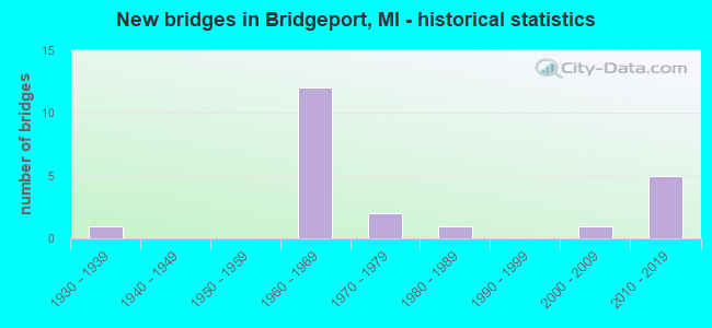
- New bridges - historical statistics
- 11930-1939
- 121960-1969
- 21970-1979
- 11980-1989
- 12000-2009
- 52010-2019
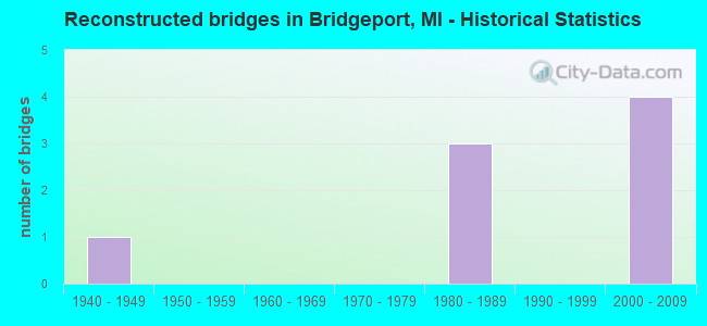
- Reconstructed bridges - Historical Statistics
- 11940-1949
- 01950-1959
- 01960-1969
- 01970-1979
- 31980-1989
- 01990-1999
- 42000-2009
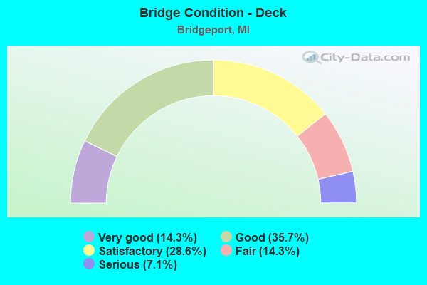
- Bridge Condition - Deck
- 14.3%Very good
- 35.7%Good
- 28.6%Satisfactory
- 14.3%Fair
- 7.1%Serious
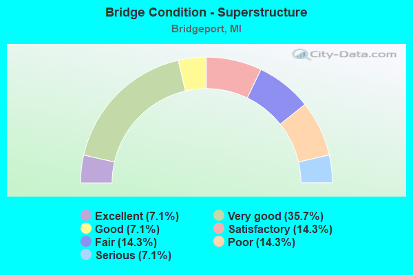
- Bridge Condition - Superstructure
- 7.1%Excellent
- 35.7%Very good
- 7.1%Good
- 14.3%Satisfactory
- 14.3%Fair
- 14.3%Poor
- 7.1%Serious
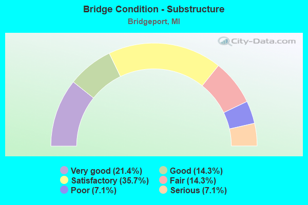
- Bridge Condition - Substructure
- 21.4%Very good
- 14.3%Good
- 35.7%Satisfactory
- 14.3%Fair
- 7.1%Poor
- 7.1%Serious
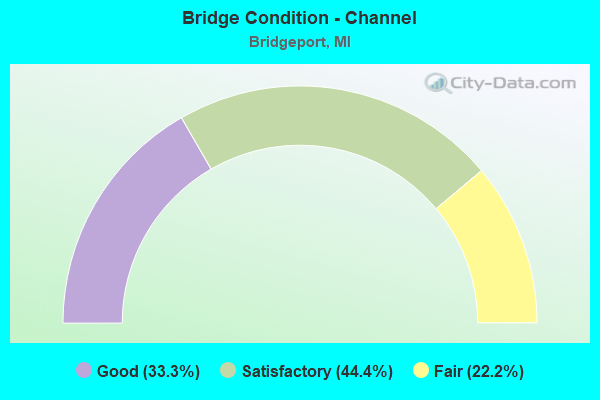
- Bridge Condition - Channel
- 33.3%Good
- 44.4%Satisfactory
- 22.2%Fair
Find on map >> Show street view
Structure Number: 9159, Location: 2.6 MI SE OF M-46 (Lat: 43.378047, Lng: -83.875703), Route carried "on" structure: County highway 2004, Year Built: 2015, Status: Open, Structure Length: 6.37m (20.90ft), Average Daily Traffic: 1,921 (year 1996), Truck Traffic: 3%, Average Future Daily Traffic: 1,200 (year 2035), Design Load: Greater than HL93, Features Intersected: I-75, Facility Carried by Structure: KING RD
Minimum Vertical Clearance: 30.48m (100.00ft), Kilometerpoint: 3.357, Lanes on structure: 2, Lanes under structure: 8, Owner: State Highway Agency, Approaching Roadway Width: 12.2m (40.0ft), Skew: 2 degrees, Material/Design: Prestressed concrete, Design/Construction: Stringer/Multi-beam, Number Of Spans In Main Unit: 2, Length of Maximum Span: 31.2m (102.4ft), Curb-To-Curb Width: 12.2m (40.0ft), Out-to-Out Width: 13.2m (43.3ft)
Condition: Deck: Very good, Superstructure: Excellent, Substructure: Very good, Operating Rating: 55.7 metric tons, Method Used To Determine Operating Rating: Load and Resistance Factor Rating (LRFR) rating reported by rating factor(RF) method using HL-93 loadings, Inventory Rating: 43.1 metric tons, Method Used To Determine Inventory Rating: Load and Resistance Factor Rating (LRFR) rating reported by rating factor(RF) method using HL-93 loadings, Structural Evaluation: Equal to present desirable criteria, Deck Geometry: Better than present minimum criteria, Underclear: Equal to present minimum criteria, Approach Roadway Alignment: Somewhat better than minimum adequacy, Designated Inspection Frequency: Every 24 months, Inspection Date: September 2021, Deck Structure Type: Concrete Cast-file-Place, Wearing Surface/Protective System: Wearing Surface: Monolithic Concrete, Deck Protection: Epoxy Coated Reinforcing
Find on map >> Show street view
Structure Number: 9185, Location: 10.0 MI NW OF GENESEE CO (Lat: 43.340900, Lng: -83.863581), Route carried "on" structure: Interstate 75, Year Built: 1961, Year Reconstructed: 2008, Status: Open, Structure Length: 8.53m (27.99ft), Average Daily Traffic: 25,771 (year 2007), Truck Traffic: 13%, Average Future Daily Traffic: 40,600 (year 2027), Design Load: HS 25 or greater, Features Intersected: CASS RIVER
Minimum Vertical Clearance: 30.48m (100.00ft), Kilometerpoint: 15.828, Lanes on structure: 4, Base Highway Network: Yes (Inventory Route: 46, Subroute: 3), Owner: State Highway Agency, Approaching Roadway Width: 21.5m (70.5ft), Skew: 10 degrees, Material/Design: Steel continuous, Design/Construction: Stringer/Multi-beam, Number Of Spans In Main Unit: 4, Length of Maximum Span: 21.3m (69.9ft), Curb-To-Curb Width: 21.1m (69.2ft), Out-to-Out Width: 22.1m (72.5ft)
Condition: Deck: Good, Superstructure: Very good, Substructure: Satisfactory, Channel: Fair, Operating Rating: 76.8 metric tons, Method Used To Determine Operating Rating: Load Factor (LF) rating reported by rating factor (RF) method using MS18 loading, Inventory Rating: 46.0 metric tons, Method Used To Determine Inventory Rating: Load Factor (LF) rating reported by rating factor (RF) method using MS18 loading, Structural Evaluation: Equal to present minimum criteria, Deck Geometry: Better than present minimum criteria, Waterway Adequacy: Equal to present desirable criteria, Approach Roadway Alignment: Equal to present desirable criteria, Designated Inspection Frequency: Every 24 months, Underwater Inspection Frequency: Every 60 months, Inspection Date: April 2020, Underwater Inspection Date: August 2020, Deck Structure Type: Concrete Cast-file-Place, Wearing Surface/Protective System: Wearing Surface: Monolithic Concrete, Deck Protection: Epoxy Coated Reinforcing
Find on map >> Show street view
Structure Number: 9186, Location: 10.0 MI NW OF GENESEE CO (Lat: 43.340903, Lng: -83.863892), Route carried "on" structure: Interstate 75, Year Built: 1961, Year Reconstructed: 2007, Status: Open, Structure Length: 8.53m (27.99ft), Average Daily Traffic: 25,771 (year 2007), Truck Traffic: 13%, Average Future Daily Traffic: 40,600 (year 2027), Design Load: HS 25 or greater, Features Intersected: CASS RIVER
Minimum Vertical Clearance: 30.48m (100.00ft), Kilometerpoint: 15.766, Lanes on structure: 3, Base Highway Network: Yes (Inventory Route: 46, Subroute: 2), Owner: State Highway Agency, Approaching Roadway Width: 13.4m (44.0ft), Skew: 10 degrees, Material/Design: Steel continuous, Design/Construction: Stringer/Multi-beam, Number Of Spans In Main Unit: 4, Length of Maximum Span: 21.3m (69.9ft), Curb-To-Curb Width: 21.1m (69.2ft), Out-to-Out Width: 22.1m (72.5ft)
Condition: Deck: Good, Superstructure: Good, Substructure: Satisfactory, Channel: Satisfactory, Operating Rating: 76.8 metric tons, Method Used To Determine Operating Rating: Load Factor (LF) rating reported by rating factor (RF) method using MS18 loading, Inventory Rating: 46.0 metric tons, Method Used To Determine Inventory Rating: Load Factor (LF) rating reported by rating factor (RF) method using MS18 loading, Structural Evaluation: Equal to present minimum criteria, Deck Geometry: Superior to present desirable criteria, Waterway Adequacy: Better than present minimum criteria, Approach Roadway Alignment: Equal to present desirable criteria, Designated Inspection Frequency: Every 24 months, Underwater Inspection Frequency: Every 60 months, Inspection Date: April 2020, Underwater Inspection Date: August 2020, Deck Structure Type: Concrete Cast-file-Place, Wearing Surface/Protective System: Wearing Surface: Monolithic Concrete, Deck Protection: Epoxy Coated Reinforcing
Find on map >> Show street view
Structure Number: 9195, Location: 7.0 MI NW OF GENESEE COL (Lat: 43.307381, Lng: -83.835553), Route carried "on" structure: County highway , Year Built: 1961, Year Reconstructed: 1991, Status: Open, Structure Length: 8.10m (26.57ft), Average Daily Traffic: 701 (year 1994), Truck Traffic: 3%, Average Future Daily Traffic: 110 (year 1977), Design Load: H 15, Features Intersected: I-75, Facility Carried by Structure: E TOWNLINE RD
Minimum Vertical Clearance: 30.48m (100.00ft), Kilometerpoint: 6.365, Lanes on structure: 2, Lanes under structure: 6, Owner: State Highway Agency, Approaching Roadway Width: 11.2m (36.7ft), Skew: 3 degrees, Material/Design: Steel, Design/Construction: Stringer/Multi-beam, Number Of Spans In Main Unit: 4, Length of Maximum Span: 27.4m (89.9ft), Curb-To-Curb Width: 9.0m (29.5ft), Out-to-Out Width: 10.0m (32.8ft)
Condition: Deck: Satisfactory, Superstructure: Fair, Substructure: Satisfactory, Operating Rating: 51.5 metric tons, Method Used To Determine Operating Rating: Load Factor (LF) rating reported by rating factor (RF) method using MS18 loading, Inventory Rating: 30.8 metric tons, Method Used To Determine Inventory Rating: Load Factor (LF) rating reported by rating factor (RF) method using MS18 loading, Structural Evaluation: Somewhat better than minimum adequacy, Deck Geometry: Somewhat better than minimum adequacy, Underclear: High priority of corrective action, Approach Roadway Alignment: Equal to present minimum criteria, Designated Inspection Frequency: Every 24 months, Other Special Inspection Frequency: Every 12 months, Inspection Date: August 2020, Other Special Inspection Date: August 2021, Deck Structure Type: Concrete Cast-file-Place, Wearing Surface/Protective System: Wearing Surface: Latex Concrete, Deck Protection: Epoxy Coated Reinforcing
Find on map >> Show street view
Structure Number: 9196, Location: 8.3 MI NW OF GENESEE COL (Lat: 43.321669, Lng: -83.848986), Route carried "on" structure: County highway , Year Built: 1961, Year Reconstructed: 1991, Status: Open, Structure Length: 7.79m (25.56ft), Average Daily Traffic: 1,706 (year 1996), Truck Traffic: 3%, Average Future Daily Traffic: 110 (year 1977), Design Load: H 15, Features Intersected: I-75, Facility Carried by Structure: E CURTIS RD
Minimum Vertical Clearance: 30.48m (100.00ft), Kilometerpoint: 6.871, Lanes on structure: 2, Lanes under structure: 6, Owner: State Highway Agency, Approaching Roadway Width: 12.8m (42.0ft), Skew: 3 degrees, Material/Design: Steel, Design/Construction: Stringer/Multi-beam, Number Of Spans In Main Unit: 4, Length of Maximum Span: 26.5m (86.9ft), Curb-To-Curb Width: 8.4m (27.6ft), Out-to-Out Width: 9.4m (30.8ft)
Condition: Deck: Satisfactory, Superstructure: Poor, Substructure: Satisfactory, Operating Rating: 63.5 metric tons, Method Used To Determine Operating Rating: Load Factor (LF) rating reported by rating factor (RF) method using MS18 loading, Inventory Rating: 33.7 metric tons, Method Used To Determine Inventory Rating: Load Factor (LF) rating reported by rating factor (RF) method using MS18 loading, Structural Evaluation: Meets minimum limits, Deck Geometry: Meets minimum limits, Underclear: High priority of corrective action, Approach Roadway Alignment: Equal to present minimum criteria, Designated Inspection Frequency: Every 24 months, Other Special Inspection Frequency: Every 12 months, Inspection Date: August 2021, Other Special Inspection Date: August 2021, Deck Structure Type: Concrete Cast-file-Place, Wearing Surface/Protective System: Wearing Surface: Latex Concrete
Find on map >> Show street view
Structure Number: 9197, Location: 9.7 MI NW OF GENESEE COL (Lat: 43.339658, Lng: -83.863467), Route carried "on" structure: County highway , Year Built: 1961, Year Reconstructed: 1985, Status: Open, Structure Length: 6.70m (21.98ft), Average Daily Traffic: 289 (year 1996), Truck Traffic: 3%, Average Future Daily Traffic: 1,010 (year 1977), Design Load: H 15, Features Intersected: I-75, Facility Carried by Structure: RIVERVIEW DRIVE
Minimum Vertical Clearance: 30.48m (100.00ft), Kilometerpoint: 3.373, Lanes on structure: 2, Lanes under structure: 6, Owner: State Highway Agency, Approaching Roadway Width: 12.2m (40.0ft), Skew: 1 degrees, Material/Design: Steel, Design/Construction: Stringer/Multi-beam, Number Of Spans In Main Unit: 4, Length of Maximum Span: 22.6m (74.1ft), Curb-To-Curb Width: 9.0m (29.5ft), Out-to-Out Width: 10.0m (32.8ft)
Condition: Deck: Fair, Superstructure: Fair, Substructure: Fair, Operating Rating: 52.5 metric tons, Method Used To Determine Operating Rating: Load Factor (LF) rating reported by rating factor (RF) method using MS18 loading, Inventory Rating: 27.9 metric tons, Method Used To Determine Inventory Rating: Load Factor (LF) rating reported by rating factor (RF) method using MS18 loading, Structural Evaluation: Somewhat better than minimum adequacy, Deck Geometry: Equal to present minimum criteria, Underclear: Meets minimum limits, Approach Roadway Alignment: Somewhat better than minimum adequacy, Designated Inspection Frequency: Every 24 months, Inspection Date: August 2021, Deck Structure Type: Concrete Cast-file-Place, Wearing Surface/Protective System: Wearing Surface: Epoxy Overlay
Find on map >> Show street view
Structure Number: 9198, Location: 10.5 MI NW OF GENESEE CO (Lat: 43.350556, Lng: -83.864303), Route carried "on" structure: Interstate 75, Year Built: 1961, Year Reconstructed: 2008, Status: Open, Structure Length: 6.19m (20.31ft), Average Daily Traffic: 38,300 (year 2007), Truck Traffic: 12%, Average Future Daily Traffic: 38,300 (year 2027), Design Load: HS 25 or greater, Features Intersected: GENESEE AVE
Minimum Vertical Clearance: 30.48m (100.00ft), Kilometerpoint: 17.444, Lanes on structure: 5, Lanes under structure: 5, Base Highway Network: Yes (Inventory Route: 46, Subroute: 5), Owner: State Highway Agency, Approaching Roadway Width: 24.9m (81.7ft), Skew: 14 degrees, Material/Design: Steel, Design/Construction: Stringer/Multi-beam, Number Of Spans In Main Unit: 3, Length of Maximum Span: 31.7m (104.0ft), Curb-To-Curb Width: 23.6m (77.4ft), Out-to-Out Width: 24.6m (80.7ft)
Condition: Deck: Good, Superstructure: Very good, Substructure: Good, Operating Rating: 70.8 metric tons, Method Used To Determine Operating Rating: Load Factor (LF), Inventory Rating: 42.4 metric tons, Method Used To Determine Inventory Rating: Load Factor (LF), Structural Evaluation: Better than present minimum criteria, Deck Geometry: Equal to present minimum criteria, Underclear: High priority of corrective action, Approach Roadway Alignment: Equal to present desirable criteria, Designated Inspection Frequency: Every 24 months, Inspection Date: April 2020, Deck Structure Type: Concrete Cast-file-Place, Wearing Surface/Protective System: Deck Protection: Epoxy Coated Reinforcing
Find on map >> Show street view
Structure Number: 9199, Location: 10.5 MI NW OF GENESEE CO (Lat: 43.350750, Lng: -83.864689), Route carried "on" structure: Interstate 75, Year Built: 1961, Year Reconstructed: 2007, Status: Open, Structure Length: 6.19m (20.31ft), Average Daily Traffic: 36,850 (year 2007), Truck Traffic: 12%, Average Future Daily Traffic: 36,850 (year 2027), Design Load: HS 25 or greater, Features Intersected: GENESEE AVE
Minimum Vertical Clearance: 30.48m (100.00ft), Kilometerpoint: 17.483, Lanes on structure: 4, Lanes under structure: 5, Base Highway Network: Yes (Inventory Route: 46, Subroute: 5), Owner: State Highway Agency, Approaching Roadway Width: 21.2m (69.6ft), Skew: 14 degrees, Material/Design: Steel, Design/Construction: Stringer/Multi-beam, Number Of Spans In Main Unit: 3, Length of Maximum Span: 31.7m (104.0ft), Curb-To-Curb Width: 21.1m (69.2ft), Out-to-Out Width: 22.1m (72.5ft)
Condition: Deck: Satisfactory, Superstructure: Very good, Substructure: Good, Operating Rating: 79.9 metric tons, Method Used To Determine Operating Rating: Load Factor (LF), Inventory Rating: 47.8 metric tons, Method Used To Determine Inventory Rating: Load Factor (LF), Structural Evaluation: Better than present minimum criteria, Deck Geometry: Better than present minimum criteria, Underclear: High priority of corrective action, Approach Roadway Alignment: Equal to present desirable criteria, Designated Inspection Frequency: Every 24 months, Inspection Date: April 2020, Deck Structure Type: Concrete Cast-file-Place, Wearing Surface/Protective System: Deck Protection: Epoxy Coated Reinforcing
Find on map >> Show street view
Structure Number: 9258, Location: 1.0 MI N OF BUSCH ROAD (Lat: 43.317031, Lng: -83.933525), Route carried "on" structure: County highway 7365, Year Built: 1986, Status: Open, Structure Length: 0.73m (2.40ft), Average Daily Traffic: 1,694 (year 2018), Truck Traffic: 5%, Average Future Daily Traffic: 1,779 (year 2028), Design Load: HS 20+Mod, Features Intersected: BIRCH RUN OVERFLOW, Facility Carried by Structure: SHERIDAN ROAD
Minimum Vertical Clearance: 30.48m (100.00ft), Kilometerpoint: 20.480, Lanes on structure: 2, Owner: County Highway Agency, Approaching Roadway Width: 9.0m (29.5ft), Material/Design: Concrete, Design/Construction: Culvert, Number Of Spans In Main Unit: 1, Length of Maximum Span: 6.7m (22.0ft), Curb-To-Curb Width: 12.1m (39.7ft), Out-to-Out Width: 13.4m (44.0ft)
Condition: Channel: Good, Culverts: Poor, Operating Rating: 79.4 metric tons, Method Used To Determine Operating Rating: Load Factor (LF) rating reported by rating factor (RF) method using MS18 loading, Inventory Rating: 47.3 metric tons, Method Used To Determine Inventory Rating: Load Factor (LF) rating reported by rating factor (RF) method using MS18 loading, Structural Evaluation: Meets minimum limits, Deck Geometry: Equal to present minimum criteria, Waterway Adequacy: Equal to present minimum criteria, Approach Roadway Alignment: Equal to present desirable criteria, Designated Inspection Frequency: Every 12 months, Inspection Date: May 2021, Deck Structure Type: Concrete Precast Panels, Wearing Surface/Protective System: Wearing Surface: Bituminous, Membrane: Preformed Fabric, Deck Protection: Epoxy Coated Reinforcing
Find on map >> Show street view
Structure Number: 926, Location: 0.8 MI N OF YOUNG ROAD (Lat: 43.362242, Lng: -83.934939), Route carried "on" structure: County highway 7365, Year Built: 2002, Status: Open, Structure Length: 6.09m (19.98ft), Average Daily Traffic: 1,931 (year 2018), Truck Traffic: 5%, Average Future Daily Traffic: 2,028 (year 2028), Design Load: HS 20, Features Intersected: CASS RIVER, Facility Carried by Structure: SHERIDAN ROAD
Minimum Vertical Clearance: 30.48m (100.00ft), Kilometerpoint: 25.556, Lanes on structure: 2, Owner: County Highway Agency, Approaching Roadway Width: 9.1m (29.9ft), Skew: 2 degrees, Material/Design: Prestressed concrete, Design/Construction: Box Beam or Girders - Single/Spread, Number Of Spans In Main Unit: 3, Length of Maximum Span: 23.2m (76.1ft), Curb-To-Curb Width: 9.1m (29.9ft), Out-to-Out Width: 9.9m (32.5ft)
Condition: Deck: Good, Superstructure: Satisfactory, Substructure: Satisfactory, Channel: Good, Operating Rating: 64.2 metric tons, Method Used To Determine Operating Rating: Load and Resistance Factor Rating (LRFR) rating reported by rating factor(RF) method using HL-93 loadings, Inventory Rating: 44.7 metric tons, Method Used To Determine Inventory Rating: Load and Resistance Factor Rating (LRFR) rating reported by rating factor(RF) method using HL-93 loadings, Structural Evaluation: Equal to present minimum criteria, Deck Geometry: Somewhat better than minimum adequacy, Waterway Adequacy: Equal to present minimum criteria, Approach Roadway Alignment: Equal to present desirable criteria, Designated Inspection Frequency: Every 24 months, Inspection Date: May 2021, Deck Structure Type: Concrete Cast-file-Place, Wearing Surface/Protective System: Wearing Surface: Monolithic Concrete
Find on map >> Show street view
Structure Number: 9264, Location: 0.7 MI N OF BUSCH ROAD (Lat: 43.303164, Lng: -83.894308), Route carried "on" structure: County highway 7375, Year Built: 1936, Year Reconstructed: 1948, Status: Open, Structure Length: 1.34m (4.40ft), Average Daily Traffic: 751 (year 2011), Truck Traffic: 5%, Average Future Daily Traffic: 786 (year 2021), Design Load: H 15, Features Intersected: BIRCH RUN CREEK, Facility Carried by Structure: BELL ROAD
Minimum Vertical Clearance: 30.48m (100.00ft), Kilometerpoint: 2.409, Lanes on structure: 2, Owner: County Highway Agency, Approaching Roadway Width: 8.5m (27.9ft), Material/Design: Steel, Design/Construction: Stringer/Multi-beam, Number Of Spans In Main Unit: 1, Length of Maximum Span: 12.2m (40.0ft), Curb-To-Curb Width: 8.2m (26.9ft), Out-to-Out Width: 9.0m (29.5ft)
Condition: Deck: Serious, Superstructure: Serious, Substructure: Poor, Channel: Satisfactory, Operating Rating: 73.9 metric tons, Method Used To Determine Operating Rating: Load Factor (LF) rating reported by rating factor (RF) method using MS18 loading, Inventory Rating: 44.4 metric tons, Method Used To Determine Inventory Rating: Load Factor (LF) rating reported by rating factor (RF) method using MS18 loading, Structural Evaluation: High priority of corrective action, Deck Geometry: Somewhat better than minimum adequacy, Waterway Adequacy: Somewhat better than minimum adequacy, Approach Roadway Alignment: Equal to present minimum criteria, Length Of Structure Improvement: 1.52m (4.99ft), Designated Inspection Frequency: Every 12 months, Inspection Date: May 2021, Bridge Improvement Cost: $400,000, Roadway Improvement Cost: $80,000, Total Project Cost: $480,000, Deck Structure Type: Concrete Cast-file-Place, Wearing Surface/Protective System: Wearing Surface: Bituminous
Find on map >> Show street view
Structure Number: 9265, Location: 0.3 MI N OF GABEL ROAD (Lat: 43.348872, Lng: -83.883672), Route carried "on" structure: County highway 7375, Year Built: 2010, Status: Open, Structure Length: 7.89m (25.89ft), Average Daily Traffic: 4,801 (year 2017), Truck Traffic: 5%, Average Future Daily Traffic: 5,041 (year 2027), Features Intersected: CASS RIVER, Facility Carried by Structure: FORT ROAD
Minimum Vertical Clearance: 30.48m (100.00ft), Kilometerpoint: 1.096, Lanes on structure: 2, Owner: County Highway Agency, Approaching Roadway Width: 9.1m (29.9ft), Skew: 2 degrees, Material/Design: Prestressed concrete, Design/Construction: Stringer/Multi-beam, Number Of Spans In Main Unit: 3, Length of Maximum Span: 26.3m (86.3ft), Curb or Sidewalk Widths: Left: 2.4m (7.9ft), Right: 0.0m, Curb-To-Curb Width: 9.1m (29.9ft), Out-to-Out Width: 12.7m (41.7ft)
Condition: Deck: Very good, Superstructure: Very good, Substructure: Very good, Channel: Good, Operating Rating: 56.7 metric tons, Method Used To Determine Operating Rating: Load and Resistance Factor Rating (LRFR) rating reported by rating factor(RF) method using HL-93 loadings, Inventory Rating: 43.7 metric tons, Method Used To Determine Inventory Rating: Load and Resistance Factor Rating (LRFR) rating reported by rating factor(RF) method using HL-93 loadings, Structural Evaluation: Equal to present desirable criteria, Deck Geometry: Meets minimum limits, Waterway Adequacy: Equal to present minimum criteria, Approach Roadway Alignment: Equal to present minimum criteria, Designated Inspection Frequency: Every 24 months, Inspection Date: November 2020, Deck Structure Type: Concrete Cast-file-Place, Wearing Surface/Protective System: Wearing Surface: Monolithic Concrete, Deck Protection: Epoxy Coated Reinforcing
Find on map >> Show street view
Structure Number: 9269, Location: 0.1 MI N OF NOTT ROAD (Lat: 43.330086, Lng: -83.829775), Route carried "on" structure: County highway 7391, Year Built: 2011, Status: Open, Structure Length: 8.08m (26.51ft), Average Daily Traffic: 6,823 (year 2011), Truck Traffic: 7%, Average Future Daily Traffic: 12,323 (year 2031), Design Load: HL 93, Features Intersected: CASS RIVER, Facility Carried by Structure: DIXIE HIGHWAY
Minimum Vertical Clearance: 30.48m (100.00ft), Kilometerpoint: 13.847, Lanes on structure: 4, Owner: County Highway Agency, Approaching Roadway Width: 18.3m (60.0ft), Material/Design: Prestressed concrete, Design/Construction: Stringer/Multi-beam, Number Of Spans In Main Unit: 3, Length of Maximum Span: 26.5m (86.9ft), Curb-To-Curb Width: 19.5m (64.0ft), Out-to-Out Width: 20.2m (66.3ft)
Condition: Deck: Good, Superstructure: Very good, Substructure: Very good, Channel: Fair, Operating Rating: 77.4 metric tons, Method Used To Determine Operating Rating: Load and Resistance Factor Rating (LRFR) rating reported by rating factor(RF) method using HL-93 loadings, Inventory Rating: 37.9 metric tons, Method Used To Determine Inventory Rating: Load and Resistance Factor Rating (LRFR) rating reported by rating factor(RF) method using HL-93 loadings, Structural Evaluation: Equal to present desirable criteria, Deck Geometry: Better than present minimum criteria, Waterway Adequacy: Better than present minimum criteria, Approach Roadway Alignment: Equal to present desirable criteria, Designated Inspection Frequency: Every 24 months, Inspection Date: April 2021, Deck Structure Type: Concrete Cast-file-Place, Wearing Surface/Protective System: Wearing Surface: Monolithic Concrete, Deck Protection: Epoxy Coated Reinforcing
Find on map >> Show street view
Structure Number: 942, Location: 0.5 MI N OF BUSCH ROAD (Lat: 43.305589, Lng: -83.914053), Route carried "on" structure: ServiceCounty highway , Year Built: 1973, Status: Posted for load, Structure Length: 1.22m (4.00ft), Average Daily Traffic: 467 (year 2017), Truck Traffic: 5%, Average Future Daily Traffic: 490 (year 2027), Design Load: H 20, Features Intersected: BIRCH RUN CREEK, Facility Carried by Structure: DORWOOD ROAD
Minimum Vertical Clearance: 30.48m (100.00ft), Kilometerpoint: 0.801, Lanes on structure: 2, Owner: County Highway Agency, Approaching Roadway Width: 9.8m (32.2ft), Material/Design: Prestressed concrete, Design/Construction: Tee Beam, Number Of Spans In Main Unit: 1, Length of Maximum Span: 11.2m (36.7ft), Curb-To-Curb Width: 7.9m (25.9ft), Out-to-Out Width: 8.5m (27.9ft)
Condition: Deck: Fair, Superstructure: Poor, Substructure: Fair, Channel: Satisfactory, Operating Rating: 35.9 metric tons, Method Used To Determine Operating Rating: Field evaluation and documented engineering judgment, Inventory Rating: 21.6 metric tons, Method Used To Determine Inventory Rating: Field evaluation and documented engineering judgment, Structural Evaluation: Meets minimum limits, Deck Geometry: Somewhat better than minimum adequacy, Waterway Adequacy: Meets minimum limits, Approach Roadway Alignment: Better than present minimum criteria, Bridge Posting: Required (Relationship of Operating Rating to Maximum Legal Load: 20.0 - 29.9% below), Designated Inspection Frequency: Every 12 months, Inspection Date: May 2021, Deck Structure Type: Concrete Precast Panels, Wearing Surface/Protective System: Wearing Surface: Bituminous
Find on map >> Show street view
Structure Number: 13837, Location: DAVIS PARK (Lat: 43.355000, Lng: -83.880994), Route carried "on" structure: Other road , Year Built: 1979, Status: Posted for load, Structure Length: 1.52m (4.99ft), Average Daily Traffic: 6 (year 2014), Average Future Daily Traffic: 9 (year 2034), Features Intersected: CASS RIVER OVERFLOW, Facility Carried by Structure: DAVIS PARK
Minimum Vertical Clearance: 30.48m (100.00ft), Kilometerpoint: 1.025, Lanes on structure: 1, Owner: Town or Township Highway Agency, Approaching Roadway Width: 3.8m (12.5ft), Material/Design: Wood or Timber, Design/Construction: Slab, Number Of Spans In Main Unit: 3, Length of Maximum Span: 7.9m (25.9ft), Curb or Sidewalk Widths: Left: 0.2m (0.7ft), Right: 0.2m (0.7ft), Curb-To-Curb Width: 3.8m (12.5ft), Out-to-Out Width: 4.2m (13.8ft)
Condition: Deck: Satisfactory, Superstructure: Satisfactory, Substructure: Serious, Channel: Satisfactory, Operating Rating: 37.3 metric tons, Method Used To Determine Operating Rating: Allowable Stress (AS) rating reported by rating factor (RF) method using MS18 loading, Inventory Rating: 26.2 metric tons, Method Used To Determine Inventory Rating: Allowable Stress (AS) rating reported by rating factor (RF) method using MS18 loading, Structural Evaluation: High priority of corrective action, Deck Geometry: Meets minimum limits, Waterway Adequacy: Equal to present desirable criteria, Approach Roadway Alignment: Meets minimum limits, Bridge Posting: Required (Relationship of Operating Rating to Maximum Legal Load: > 39.9% below), Designated Inspection Frequency: Every 12 months, Inspection Date: January 2022, Deck Structure Type: Wood or Timber, Wearing Surface/Protective System: Wearing Surface: Wood or Timber
Find on map >> Show street view
Structure Number: 9158, Location: 3.6 MI SE OF M-46 (Lat: 43.365203, Lng: -83.867514), Route carried "under" structure: Interstate 75, Year Built: 2015, Structure Length: 0. m, Average Daily Traffic: 59,200 (year 2013), Truck Traffic: 7%, Features Intersected: I-75, Facility Carried by Structure: BAKER RD
Minimum Vertical Clearance: 5.64m (18.50ft), Kilometerpoint: 18.502, Lanes on structure: 2, Lanes under structure: 8, Material/Design: Prestressed concrete, Design/Construction: Stringer/Multi-beam, Length of Maximum Span: 29.7m (97.4ft)
Find on map >> Show street view
Structure Number: 9159, Location: 2.6 MI SE OF M-46 (Lat: 43.378047, Lng: -83.875703), Route carried "under" structure: Interstate 75, Year Built: 2015, Structure Length: 0. m, Average Daily Traffic: 59,200 (year 2013), Truck Traffic: 7%, Features Intersected: I-75, Facility Carried by Structure: KING RD
Minimum Vertical Clearance: 5.39m (17.68ft), Kilometerpoint: 20.082, Lanes on structure: 2, Lanes under structure: 8, Material/Design: Prestressed concrete, Design/Construction: Stringer/Multi-beam, Length of Maximum Span: 31.2m (102.4ft)
Find on map >> Show street view
Structure Number: 9195, Location: 7.0 MI NW OF GENESEE COL (Lat: 43.307381, Lng: -83.835553), Route carried "under" structure: Interstate 75, Year Built: 1961, Structure Length: 0. m, Average Daily Traffic: 51,542 (year 2007), Truck Traffic: 13%, Features Intersected: I-75, Facility Carried by Structure: E TOWNLINE RD
Minimum Vertical Clearance: 5.16m (16.93ft), Kilometerpoint: 11.358, Lanes on structure: 2, Lanes under structure: 6, Material/Design: Steel, Design/Construction: Stringer/Multi-beam, Length of Maximum Span: 27.4m (89.9ft)
Find on map >> Show street view
Structure Number: 9196, Location: 8.3 MI NW OF GENESEE COL (Lat: 43.321669, Lng: -83.848986), Route carried "under" structure: Interstate 75, Year Built: 1961, Structure Length: 0. m, Average Daily Traffic: 51,542 (year 2007), Truck Traffic: 13%, Features Intersected: I-75, Facility Carried by Structure: E CURTIS RD
Minimum Vertical Clearance: 5.11m (16.77ft), Kilometerpoint: 13.284, Lanes on structure: 2, Lanes under structure: 6, Material/Design: Steel, Design/Construction: Stringer/Multi-beam, Length of Maximum Span: 26.5m (86.9ft)
Find on map >> Show street view
Structure Number: 9197, Location: 9.7 MI NW OF GENESEE COL (Lat: 43.339658, Lng: -83.863467), Route carried "under" structure: Interstate 75, Year Built: 1961, Structure Length: 0. m, Average Daily Traffic: 51,542 (year 2007), Truck Traffic: 13%, Features Intersected: I-75, Facility Carried by Structure: RIVERVIEW DRIVE
Minimum Vertical Clearance: 5.44m (17.85ft), Kilometerpoint: 15.627, Lanes on structure: 2, Lanes under structure: 6, Material/Design: Steel, Design/Construction: Stringer/Multi-beam, Length of Maximum Span: 22.6m (74.1ft)
Find on map >> Show street view
Structure Number: 9198, Location: 10.5 MI NW OF GENESEE CO (Lat: 43.350556, Lng: -83.864303), Route carried "under" structure: County highway 2004, Year Built: 1961, Structure Length: 0. m, Average Daily Traffic: 16,549 (year 1995), Features Intersected: GENESEE AVE, Facility Carried by Structure: I-75 NB
Minimum Vertical Clearance: 4.39m (14.40ft), Kilometerpoint: 16.847, Lanes on structure: 5, Lanes under structure: 5, Material/Design: Steel, Design/Construction: Stringer/Multi-beam, Length of Maximum Span: 31.7m (104.0ft)
Find on map >> Show street view
Structure Number: 9199, Location: 10.5 MI NW OF GENESEE CO (Lat: 43.350750, Lng: -83.864689), Route carried "under" structure: City street 2004, Year Built: 1961, Structure Length: 0. m, Average Daily Traffic: 16,549 (year 1995), Features Intersected: GENESEE AVE, Facility Carried by Structure: I-75 SB
Minimum Vertical Clearance: 4.47m (14.67ft), Kilometerpoint: 16.870, Lanes on structure: 4, Lanes under structure: 5, Material/Design: Steel, Design/Construction: Stringer/Multi-beam, Length of Maximum Span: 31.7m (104.0ft)