Bridge Statistics for Bridgeport, Nebraska (NE)
Condition, Traffic, Stress, Structural Evaluation, Project Costs
- National Bridge Inventory (NBI) Statistics
- 16Number of bridges
- 154ft / 47.1mTotal length
- 31,670Total average daily traffic
- 4,309Total average daily truck traffic
- National Bridge Inventory (NBI) Registered Bridges for Bridgeport
- No street view available for this location
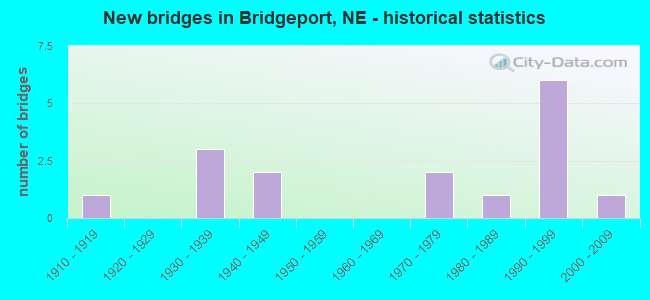
- New bridges - historical statistics
- 11910-1919
- 31930-1939
- 21940-1949
- 21970-1979
- 11980-1989
- 61990-1999
- 12000-2009

- Reconstructed bridges - Historical Statistics
- 11970-1979
- 41980-1989


- Bridge Condition - Deck
- 37.5%Very good
- 25.0%Good
- 25.0%Satisfactory
- 12.5%Fair

- Bridge Condition - Superstructure
- 12.5%Excellent
- 37.5%Very good
- 37.5%Good
- 12.5%Satisfactory

- Bridge Condition - Substructure
- 12.5%Excellent
- 25.0%Very good
- 25.0%Good
- 12.5%Satisfactory
- 25.0%Fair

- Bridge Condition - Channel
- 9.1%Excellent
- 63.6%Very good
- 9.1%Good
- 9.1%Satisfactory
- 9.1%Fair

- Bridge Condition - Culverts
- 20.0%Excellent
- 40.0%Very good
- 20.0%Good
- 20.0%Satisfactory
Find on map >> Show street view
Structure Number: C00621421, Location: 3N 1.5W BRIDGEPORT (Lat: 41.713300, Lng: -103.126700), Route carried "on" structure: County highway 142, Year Built: 1975, Status: Open, Structure Length: 0.73m (2.40ft), Average Daily Traffic: 25 (year 2003), Average Future Daily Traffic: 31 (year 2033), Features Intersected: INDIAN CREEK, Facility Carried by Structure: COUNTY HIGHWAY
Minimum Vertical Clearance: 30+ m (98+ ft), Kilometerpoint: 0.000, Lanes on structure: 2, Owner: County Highway Agency, Approaching Roadway Width: 9.8m (32.2ft), Material/Design: Aluminum, Iron, Design/Construction: Culvert, Number Of Spans In Main Unit: 3, Length of Maximum Span: 2.4m (7.9ft)
Condition: Channel: Satisfactory, Culverts: Satisfactory, Operating Rating: 33.0 metric tons, Method Used To Determine Operating Rating: Field evaluation and documented engineering judgment, Inventory Rating: 26.0 metric tons, Method Used To Determine Inventory Rating: Field evaluation and documented engineering judgment, Structural Evaluation: Equal to present minimum criteria, Waterway Adequacy: Better than present minimum criteria, Approach Roadway Alignment: Equal to present desirable criteria, Designated Inspection Frequency: Every 24 months, Inspection Date: January 2021
Find on map >> Show street view
Structure Number: C006214605P, Location: .5NW BRIDGEPORT (Lat: 41.685000, Lng: -103.101700), Route carried "on" structure: County highway P146, Year Built: 1990, Status: Open, Structure Length: 0.98m (3.22ft), Average Daily Traffic: 100 (year 2003), Truck Traffic: 10%, Average Future Daily Traffic: 125 (year 2033), Features Intersected: UPPER DUGOUT CREEK, Facility Carried by Structure: COUNTY HIGHWAY
Minimum Vertical Clearance: 30+ m (98+ ft), Kilometerpoint: 0.000, Lanes on structure: 2, Owner: County Highway Agency, Approaching Roadway Width: 8.5m (27.9ft), Material/Design: Concrete, Design/Construction: Channel Beam, Number Of Spans In Main Unit: 1, Length of Maximum Span: 9.1m (29.9ft), Curb-To-Curb Width: 9.2m (30.2ft), Out-to-Out Width: 9.2m (30.2ft)
Condition: Deck: Fair, Superstructure: Excellent, Substructure: Excellent, Channel: Very good, Operating Rating: 80.0 metric tons, Method Used To Determine Operating Rating: Load Factor (LF), Inventory Rating: 48.0 metric tons, Method Used To Determine Inventory Rating: Load Factor (LF), Structural Evaluation: Superior to present desirable criteria, Deck Geometry: Better than present minimum criteria, Waterway Adequacy: Equal to present desirable criteria, Approach Roadway Alignment: Equal to present desirable criteria, Designated Inspection Frequency: Every 24 months, Inspection Date: December 2021, Deck Structure Type: Concrete Precast Panels, Wearing Surface/Protective System: Wearing Surface: Monolithic Concrete
Find on map >> Show street view
Structure Number: S026 05868, Location: 2W BRIDGEPORT (Lat: 41.670400, Lng: -103.151500), Route carried "on" structure: US 26, Year Built: 1947, Year Reconstructed: 1981, Status: Open, Structure Length: 1.07m (3.51ft), Average Daily Traffic: 2,940 (year 2018), Truck Traffic: 15%, Average Future Daily Traffic: 3,822 (year 2038), Features Intersected: BELMONT CANAL
Minimum Vertical Clearance: 30+ m (98+ ft), Kilometerpoint: 9.444, Lanes on structure: 2, Base Highway Network: Yes, Owner: State Highway Agency, Approaching Roadway Width: 12.2m (40.0ft), Skew: 4 degrees, Material/Design: Concrete, Design/Construction: Culvert, Number Of Spans In Main Unit: 2, Length of Maximum Span: 3.7m (12.1ft)
Condition: Channel: Very good, Culverts: Very good, Operating Rating: 33.0 metric tons, Method Used To Determine Operating Rating: Field evaluation and documented engineering judgment, Inventory Rating: 22.0 metric tons, Method Used To Determine Inventory Rating: Field evaluation and documented engineering judgment, Structural Evaluation: Somewhat better than minimum adequacy, Waterway Adequacy: Equal to present desirable criteria, Approach Roadway Alignment: Equal to present desirable criteria, Designated Inspection Frequency: Every 24 months, Inspection Date: June 2020
Find on map >> Show street view
Structure Number: S026 0619, Location: NCL BRIDGEPORT (Lat: 41.677600, Lng: -103.096700), Route carried "on" structure: US 26, Year Built: 1977, Status: Open, Structure Length: 18.47m (60.60ft), Average Daily Traffic: 5,000 (year 2018), Truck Traffic: 10%, Average Future Daily Traffic: 6,750 (year 2038), Features Intersected: NORTH PLATE RIVER
Minimum Vertical Clearance: 30+ m (98+ ft), Kilometerpoint: 9.962, Lanes on structure: 2, Base Highway Network: Yes, Owner: State Highway Agency, Approaching Roadway Width: 12.2m (40.0ft), Skew: 2 degrees, Material/Design: Prestressed concrete, Design/Construction: Stringer/Multi-beam, Number Of Spans In Main Unit: 9, Number Of Approach Spans: 2, Length of Maximum Span: 20.4m (66.9ft), Curb-To-Curb Width: 12.2m (40.0ft), Out-to-Out Width: 13.0m (42.7ft)
Condition: Deck: Satisfactory, Superstructure: Good, Substructure: Satisfactory, Channel: Fair, Operating Rating: 75.0 metric tons, Method Used To Determine Operating Rating: Load Factor (LF), Inventory Rating: 39.0 metric tons, Method Used To Determine Inventory Rating: Load Factor (LF), Structural Evaluation: Equal to present minimum criteria, Deck Geometry: Equal to present minimum criteria, Waterway Adequacy: Superior to present desirable criteria, Approach Roadway Alignment: Equal to present desirable criteria, Designated Inspection Frequency: Every 24 months, Inspection Date: June 2020, Deck Structure Type: Concrete Cast-file-Place, Wearing Surface/Protective System: Wearing Surface: Latex Concrete
Find on map >> Show street view
Structure Number: S026 06211, Location: 1N BRIDGEPORT (Lat: 41.680600, Lng: -103.094800), Route carried "on" structure: US 26, Year Built: 1994, Status: Open, Structure Length: 0.70m (2.30ft), Average Daily Traffic: 5,000 (year 2018), Truck Traffic: 10%, Average Future Daily Traffic: 6,750 (year 2038), Features Intersected: BROWNS CANAL
Minimum Vertical Clearance: 30+ m (98+ ft), Kilometerpoint: 9.996, Lanes on structure: 2, Base Highway Network: Yes, Owner: State Highway Agency, Approaching Roadway Width: 12.2m (40.0ft), Material/Design: Concrete, Design/Construction: Culvert, Number Of Spans In Main Unit: 2, Length of Maximum Span: 3.4m (11.2ft)
Condition: Channel: Excellent, Culverts: Excellent, Operating Rating: 43.0 metric tons, Method Used To Determine Operating Rating: Field evaluation and documented engineering judgment, Inventory Rating: 33.0 metric tons, Method Used To Determine Inventory Rating: Field evaluation and documented engineering judgment, Structural Evaluation: Superior to present desirable criteria, Waterway Adequacy: Superior to present desirable criteria, Approach Roadway Alignment: Equal to present desirable criteria, Designated Inspection Frequency: Every 48 months, Inspection Date: June 2020
Find on map >> Show street view
Structure Number: S026 06222, Location: 1N BRIDGEPORT (Lat: 41.681900, Lng: -103.093500), Route carried "on" structure: US 26, Year Built: 1994, Status: Open, Structure Length: 7.99m (26.21ft), Average Daily Traffic: 5,000 (year 2018), Truck Traffic: 10%, Average Future Daily Traffic: 6,750 (year 2038), Features Intersected: UPRR/FRNTGE RD
Minimum Vertical Clearance: 30+ m (98+ ft), Kilometerpoint: 10.013, Lanes on structure: 2, Lanes under structure: 2, Base Highway Network: Yes, Owner: State Highway Agency, Approaching Roadway Width: 12.2m (40.0ft), Skew: 1 degrees, Material/Design: Steel continuous, Design/Construction: Stringer/Multi-beam, Number Of Spans In Main Unit: 3, Length of Maximum Span: 33.8m (110.9ft), Curb-To-Curb Width: 13.4m (44.0ft), Out-to-Out Width: 14.1m (46.3ft)
Condition: Deck: Very good, Superstructure: Very good, Substructure: Very good, Operating Rating: 78.0 metric tons, Method Used To Determine Operating Rating: Load Factor (LF), Inventory Rating: 46.0 metric tons, Method Used To Determine Inventory Rating: Load Factor (LF), Structural Evaluation: Equal to present desirable criteria, Deck Geometry: Better than present minimum criteria, Underclear: Meets minimum limits, Approach Roadway Alignment: Equal to present desirable criteria, Designated Inspection Frequency: Every 24 months, Inspection Date: June 2020, Deck Structure Type: Concrete Cast-file-Place, Wearing Surface/Protective System: Wearing Surface: Monolithic Concrete, Deck Protection: Epoxy Coated Reinforcing
Find on map >> Show street view
Structure Number: S026 06723, Location: 5E NORTHPORT (Lat: 41.646200, Lng: -103.012200), Route carried "on" structure: US 26, Year Built: 1940, Year Reconstructed: 1989, Status: Open, Structure Length: 0.98m (3.22ft), Average Daily Traffic: 2,040 (year 2018), Truck Traffic: 19%, Average Future Daily Traffic: 2,754 (year 2038), Features Intersected: STREAM
Minimum Vertical Clearance: 30+ m (98+ ft), Kilometerpoint: 10.820, Lanes on structure: 2, Base Highway Network: Yes, Owner: State Highway Agency, Approaching Roadway Width: 12.2m (40.0ft), Skew: 3 degrees, Material/Design: Steel, Design/Construction: Stringer/Multi-beam, Number Of Spans In Main Unit: 1, Length of Maximum Span: 9.1m (29.9ft), Curb-To-Curb Width: 13.5m (44.3ft), Out-to-Out Width: 14.1m (46.3ft)
Condition: Deck: Good, Superstructure: Good, Substructure: Fair, Channel: Good, Operating Rating: 41.0 metric tons, Method Used To Determine Operating Rating: Load Factor (LF), Inventory Rating: 24.0 metric tons, Method Used To Determine Inventory Rating: Load Factor (LF), Structural Evaluation: Somewhat better than minimum adequacy, Deck Geometry: Superior to present desirable criteria, Waterway Adequacy: Equal to present desirable criteria, Approach Roadway Alignment: Equal to present desirable criteria, Length Of Structure Improvement: 0.98m (3.22ft), Designated Inspection Frequency: Every 24 months, Inspection Date: June 2020, Deck Structure Type: Concrete Cast-file-Place, Wearing Surface/Protective System: Wearing Surface: Low Slump Concrete, Deck Protection: Epoxy Coated Reinforcing
Find on map >> Show street view
Structure Number: S088 05357, Location: 6S BRIDGEPORT (Lat: 41.587200, Lng: -103.099900), Route carried "on" structure: State highway 88, Year Built: 1990, Status: Open, Structure Length: 2.50m (8.20ft), Average Daily Traffic: 610 (year 2018), Truck Traffic: 10%, Average Future Daily Traffic: 763 (year 2038), Features Intersected: PUMPKIN CREEK
Minimum Vertical Clearance: 30+ m (98+ ft), Kilometerpoint: 8.621, Lanes on structure: 2, Owner: State Highway Agency, Approaching Roadway Width: 7.3m (24.0ft), Material/Design: Prestressed concrete, Design/Construction: Tee Beam, Number Of Spans In Main Unit: 2, Length of Maximum Span: 12.2m (40.0ft), Curb-To-Curb Width: 11.0m (36.1ft), Out-to-Out Width: 11.7m (38.4ft)
Condition: Deck: Very good, Superstructure: Good, Substructure: Very good, Channel: Very good, Operating Rating: 96.0 metric tons, Method Used To Determine Operating Rating: Load Factor (LF), Inventory Rating: 57.0 metric tons, Method Used To Determine Inventory Rating: Load Factor (LF), Structural Evaluation: Better than present minimum criteria, Deck Geometry: Better than present minimum criteria, Waterway Adequacy: Equal to present desirable criteria, Approach Roadway Alignment: Equal to present desirable criteria, Designated Inspection Frequency: Every 24 months, Inspection Date: June 2020, Deck Structure Type: Concrete Cast-file-Place, Wearing Surface/Protective System: Wearing Surface: Monolithic Concrete, Deck Protection: Epoxy Coated Reinforcing
Find on map >> Show street view
Structure Number: S088 05695, Location: 2S BRIDGEPORT (Lat: 41.636500, Lng: -103.099300), Route carried "on" structure: State highway 88, Year Built: 1990, Status: Open, Structure Length: 0.88m (2.89ft), Average Daily Traffic: 610 (year 2018), Truck Traffic: 10%, Average Future Daily Traffic: 763 (year 2038), Features Intersected: BELMONT CANAL
Minimum Vertical Clearance: 30+ m (98+ ft), Kilometerpoint: 9.165, Lanes on structure: 2, Owner: State Highway Agency, Approaching Roadway Width: 7.3m (24.0ft), Skew: 4 degrees, Material/Design: Concrete, Design/Construction: Culvert, Number Of Spans In Main Unit: 2, Length of Maximum Span: 3.0m (9.8ft)
Condition: Channel: Very good, Culverts: Good, Operating Rating: 33.0 metric tons, Method Used To Determine Operating Rating: Field evaluation and documented engineering judgment, Inventory Rating: 22.0 metric tons, Method Used To Determine Inventory Rating: Field evaluation and documented engineering judgment, Structural Evaluation: Somewhat better than minimum adequacy, Waterway Adequacy: Equal to present desirable criteria, Approach Roadway Alignment: Equal to present desirable criteria, Designated Inspection Frequency: Every 24 months, Inspection Date: June 2020
Find on map >> Show street view
Structure Number: S385 06909, Location: SJCT US385/N92 3.1NW (Lat: 41.626600, Lng: -103.036600), Route carried "on" structure: US 385, Year Built: 1982, Status: Open, Structure Length: 2.44m (8.01ft), Average Daily Traffic: 2,805 (year 2018), Truck Traffic: 18%, Average Future Daily Traffic: 4,208 (year 2038), Features Intersected: PUMPKIN CREEK
Minimum Vertical Clearance: 30+ m (98+ ft), Kilometerpoint: 11.119, Lanes on structure: 2, Base Highway Network: Yes, Owner: State Highway Agency, Approaching Roadway Width: 12.2m (40.0ft), Skew: 3 degrees, Material/Design: Concrete continuous, Design/Construction: Slab, Number Of Spans In Main Unit: 3, Length of Maximum Span: 9.8m (32.2ft), Curb-To-Curb Width: 12.2m (40.0ft), Out-to-Out Width: 12.9m (42.3ft)
Condition: Deck: Satisfactory, Superstructure: Satisfactory, Substructure: Good, Channel: Very good, Operating Rating: 58.0 metric tons, Method Used To Determine Operating Rating: Load Factor (LF), Inventory Rating: 34.0 metric tons, Method Used To Determine Inventory Rating: Load Factor (LF), Structural Evaluation: Equal to present minimum criteria, Deck Geometry: Equal to present minimum criteria, Waterway Adequacy: Equal to present desirable criteria, Approach Roadway Alignment: Equal to present desirable criteria, Designated Inspection Frequency: Every 24 months, Inspection Date: June 2020, Deck Structure Type: Concrete Cast-file-Place, Wearing Surface/Protective System: Wearing Surface: Monolithic Concrete, Deck Protection: Epoxy Coated Reinforcing
Find on map >> Show street view
Structure Number: S385 07539, Location: 2NW BRIDGEPORT (Lat: 41.690000, Lng: -103.099700), Route carried "on" structure: US 385, Year Built: 1935, Year Reconstructed: 1986, Status: Open, Structure Length: 4.88m (16.01ft), Average Daily Traffic: 2,490 (year 2018), Truck Traffic: 18%, Average Future Daily Traffic: 3,362 (year 2038), Features Intersected: UPPER DUGOUT CREEK
Minimum Vertical Clearance: 30+ m (98+ ft), Kilometerpoint: 12.133, Lanes on structure: 2, Base Highway Network: Yes, Owner: State Highway Agency, Approaching Roadway Width: 12.2m (40.0ft), Material/Design: Concrete continuous, Design/Construction: Slab, Number Of Spans In Main Unit: 7, Length of Maximum Span: 9.8m (32.2ft), Curb or Sidewalk Widths: Left: 0.2m (0.7ft), Right: 0.2m (0.7ft), Curb-To-Curb Width: 12.2m (40.0ft), Out-to-Out Width: 13.0m (42.7ft)
Condition: Deck: Very good, Superstructure: Very good, Substructure: Fair, Channel: Very good, Operating Rating: 37.0 metric tons, Method Used To Determine Operating Rating: Load Factor (LF), Inventory Rating: 22.0 metric tons, Method Used To Determine Inventory Rating: Load Factor (LF), Structural Evaluation: Somewhat better than minimum adequacy, Deck Geometry: Equal to present minimum criteria, Waterway Adequacy: Equal to present desirable criteria, Approach Roadway Alignment: Equal to present desirable criteria, Designated Inspection Frequency: Every 24 months, Inspection Date: June 2020, Deck Structure Type: Concrete Cast-file-Place, Wearing Surface/Protective System: Wearing Surface: Bituminous, Membrane: Preformed Fabric, Deck Protection: Epoxy Coated Reinforcing
Find on map >> Show street view
Structure Number: S385 07652, Location: 3NW BRIDGEPORT (Lat: 41.702000, Lng: -103.114600), Route carried "on" structure: US 385, Year Built: 1935, Year Reconstructed: 1986, Status: Open, Structure Length: 4.33m (14.21ft), Average Daily Traffic: 2,490 (year 2018), Truck Traffic: 18%, Average Future Daily Traffic: 3,362 (year 2038), Design Load: H 15, Features Intersected: BNSF RR 089-083-P
Minimum Vertical Clearance: 30+ m (98+ ft), Kilometerpoint: 12.315, Lanes on structure: 2, Base Highway Network: Yes, Owner: State Highway Agency, Approaching Roadway Width: 12.2m (40.0ft), Skew: 4 degrees, Material/Design: Steel continuous, Design/Construction: Stringer/Multi-beam, Number Of Spans In Main Unit: 3, Length of Maximum Span: 14.3m (46.9ft), Curb or Sidewalk Widths: Left: 0.2m (0.7ft), Right: 0.2m (0.7ft), Curb-To-Curb Width: 12.2m (40.0ft), Out-to-Out Width: 13.0m (42.7ft)
Condition: Deck: Good, Superstructure: Very good, Substructure: Good, Operating Rating: 34.0 metric tons, Method Used To Determine Operating Rating: Load Factor (LF), Inventory Rating: 20.0 metric tons, Method Used To Determine Inventory Rating: Load Factor (LF), Structural Evaluation: Somewhat better than minimum adequacy, Deck Geometry: Equal to present minimum criteria, Underclear: Somewhat better than minimum adequacy, Approach Roadway Alignment: Equal to present desirable criteria, Bridge Posting: Required (Relationship of Operating Rating to Maximum Legal Load: 0.1 - 9.9% below), Designated Inspection Frequency: Every 24 months, Inspection Date: June 2020, Deck Structure Type: Concrete Cast-file-Place, Wearing Surface/Protective System: Wearing Surface: Low Slump Concrete, Deck Protection: Epoxy Coated Reinforcing
Find on map >> Show street view
Structure Number: S385 07764, Location: 4NW BRIDGEPORT (Lat: 41.717500, Lng: -103.118600), Route carried "on" structure: US 385, Year Built: 1936, Year Reconstructed: 1986, Status: Open, Structure Length: 1.19m (3.90ft), Average Daily Traffic: 2,490 (year 2018), Truck Traffic: 18%, Average Future Daily Traffic: 3,362 (year 2038), Features Intersected: INDIAN CREEK
Minimum Vertical Clearance: 30+ m (98+ ft), Kilometerpoint: 12.495, Lanes on structure: 2, Base Highway Network: Yes, Owner: State Highway Agency, Approaching Roadway Width: 12.2m (40.0ft), Material/Design: Concrete, Design/Construction: Culvert, Number Of Spans In Main Unit: 3, Length of Maximum Span: 3.7m (12.1ft)
Condition: Channel: Very good, Culverts: Very good, Operating Rating: 33.0 metric tons, Method Used To Determine Operating Rating: Field evaluation and documented engineering judgment, Inventory Rating: 22.0 metric tons, Method Used To Determine Inventory Rating: Field evaluation and documented engineering judgment, Structural Evaluation: Somewhat better than minimum adequacy, Waterway Adequacy: Equal to present desirable criteria, Approach Roadway Alignment: Equal to present desirable criteria, Designated Inspection Frequency: Every 24 months, Inspection Date: June 2020
Find on map >> Show street view
Structure Number: C006214215, Location: 2.7N BRIDGEPORT (Lat: 41.713300, Lng: -103.106700), Route carried "under" structure: County highway 142, Year Built: 1916, Structure Length: 0. m, Average Daily Traffic: 25 (year 2003), Features Intersected: BNSF RR 089-084-W, Facility Carried by Structure: BNSF RR
Minimum Vertical Clearance: 3.81m (12.50ft), Kilometerpoint: 0.000, Lanes under structure: 2, Material/Design: Concrete, Design/Construction: Slab, Length of Maximum Span: 5.5m (18.0ft)
Find on map >> Show street view
Structure Number: C006214216, Location: 2.7N BRIDGEPORT (Lat: 41.713600, Lng: -103.106700), Route carried "under" structure: County highway 142, Year Built: 2006, Structure Length: 0. m, Average Daily Traffic: 25 (year 2003), Features Intersected: BNSF RR, Facility Carried by Structure: BNSF RR
Minimum Vertical Clearance: 4.67m (15.32ft), Kilometerpoint: 0.000, Lanes under structure: 1, Material/Design: Prestressed concrete, Design/Construction: Stringer/Multi-beam, Length of Maximum Span: 14.3m (46.9ft)
Find on map >> Show street view
Structure Number: S026 06222, Location: 1N BRIDGEPORT (Lat: 41.681900, Lng: -103.093500), Route carried "under" structure: County highway P529, Year Built: 1994, Structure Length: 0. m, Average Daily Traffic: 20 (year 1997), Truck Traffic: 5%, Features Intersected: UPRR/FRNTGE RD, Facility Carried by Structure: US26/US385
Minimum Vertical Clearance: 7.87m (25.82ft), Kilometerpoint: 0.000, Lanes on structure: 2, Lanes under structure: 2, Material/Design: Steel continuous, Design/Construction: Stringer/Multi-beam, Length of Maximum Span: 33.8m (110.9ft)