Bridge Statistics for Bridgeport, Texas (TX)
Condition, Traffic, Stress, Structural Evaluation, Project Costs
- National Bridge Inventory (NBI) Statistics
- 25Number of bridges
- 413ft / 126mTotal length
- $180,000Total costs
- 84,656Total average daily traffic
- 7,374Total average daily truck traffic
- 118,494Total future (year 2033) average daily traffic
- National Bridge Inventory (NBI) Registered Bridges for Bridgeport
- No street view available for this location
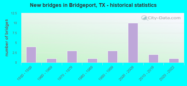
- New bridges - historical statistics
- 41950-1959
- 11960-1969
- 31970-1979
- 11980-1989
- 31990-1999
- 102000-2009
- 22010-2019
- 12020-2022
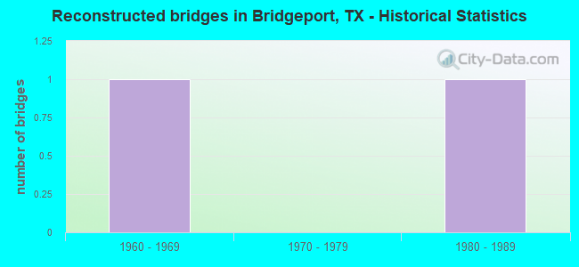
- Reconstructed bridges - Historical Statistics
- 11960-1969
- 01970-1979
- 11980-1989
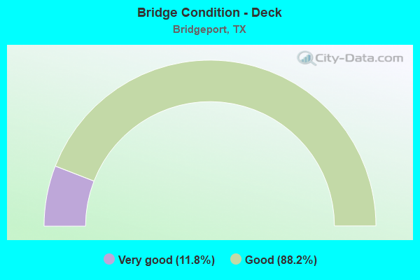
- Bridge Condition - Deck
- 11.8%Very good
- 88.2%Good
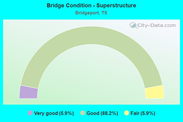
- Bridge Condition - Superstructure
- 5.9%Very good
- 88.2%Good
- 5.9%Fair
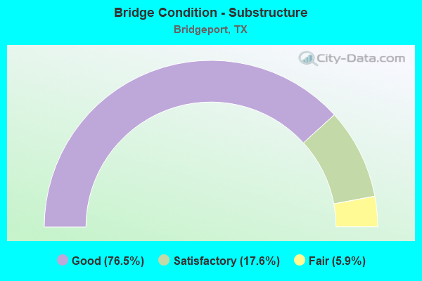
- Bridge Condition - Substructure
- 76.5%Good
- 17.6%Satisfactory
- 5.9%Fair
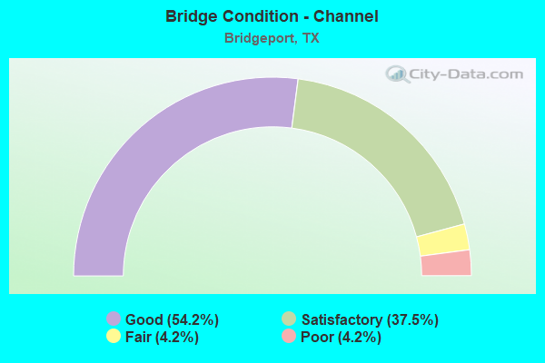
- Bridge Condition - Channel
- 54.2%Good
- 37.5%Satisfactory
- 4.2%Fair
- 4.2%Poor
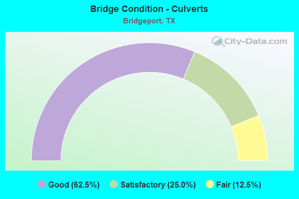
- Bridge Condition - Culverts
- 62.5%Good
- 25.0%Satisfactory
- 12.5%Fair
Find on map >> Show street view
Structure Number: 22490013407097, Location: 0.6 MI E OF FM 1655 (Lat: 33.232264, Lng: -97.692128), Route carried "on" structure: US 380, Year Built: 1999, Status: Open, Structure Length: 28.16m (92.39ft), Average Daily Traffic: 8,281 (year 2020), Truck Traffic: 10%, Average Future Daily Traffic: 9,990 (year 2035), Design Load: HS 20, Features Intersected: BIG SANDY CREEK
Minimum Vertical Clearance: 30+ m (98+ ft), Kilometerpoint: 7.099, Lanes on structure: 2, Base Highway Network: Yes, Owner: State Highway Agency, Approaching Roadway Width: 11.6m (38.1ft), Material/Design: Prestressed concrete, Design/Construction: Stringer/Multi-beam, Number Of Spans In Main Unit: 7, Number Of Approach Spans: 1, Length of Maximum Span: 37.2m (122.0ft), Curb-To-Curb Width: 13.2m (43.3ft), Out-to-Out Width: 13.8m (45.3ft)
Condition: Deck: Good, Superstructure: Good, Substructure: Good, Channel: Good, Operating Rating: 54.4 metric tons, Method Used To Determine Operating Rating: Assigned rating based on Load Factor Design (LFD) reported in metric tons, Inventory Rating: 32.7 metric tons, Method Used To Determine Inventory Rating: Assigned rating based on Load Factor Design (LFD) reported in metric tons, Structural Evaluation: Better than present minimum criteria, Deck Geometry: Superior to present desirable criteria, Waterway Adequacy: Superior to present desirable criteria, Approach Roadway Alignment: Equal to present desirable criteria, Designated Inspection Frequency: Every 24 months, Inspection Date: March 2021, Deck Structure Type: Concrete Precast Panels, Wearing Surface/Protective System: Membrane: Other, Deck Protection: Epoxy Coated Reinforcing
Find on map >> Show street view
Structure Number: 22490013407104, Location: .6 MI E OF FM 1655 (Lat: 33.231744, Lng: -97.694042), Route carried "on" structure: US 380, Year Built: 2007, Status: Open, Structure Length: 28.16m (92.39ft), Average Daily Traffic: 7,659 (year 2020), Truck Traffic: 10%, Average Future Daily Traffic: 9,990 (year 2035), Design Load: HS 20, Features Intersected: BIG SANDY CREEK
Minimum Vertical Clearance: 30+ m (98+ ft), Kilometerpoint: 7.208, Lanes on structure: 2, Base Highway Network: Yes, Owner: State Highway Agency, Approaching Roadway Width: 11.6m (38.1ft), Material/Design: Prestressed concrete, Design/Construction: Stringer/Multi-beam, Number Of Spans In Main Unit: 7, Number Of Approach Spans: 1, Length of Maximum Span: 36.9m (121.1ft), Curb-To-Curb Width: 11.4m (37.4ft), Out-to-Out Width: 12.0m (39.4ft)
Condition: Deck: Good, Superstructure: Good, Substructure: Good, Channel: Good, Operating Rating: 54.4 metric tons, Method Used To Determine Operating Rating: Assigned rating based on Load Factor Design (LFD) reported in metric tons, Inventory Rating: 32.7 metric tons, Method Used To Determine Inventory Rating: Assigned rating based on Load Factor Design (LFD) reported in metric tons, Structural Evaluation: Better than present minimum criteria, Deck Geometry: Equal to present minimum criteria, Waterway Adequacy: Superior to present desirable criteria, Approach Roadway Alignment: Equal to present desirable criteria, Designated Inspection Frequency: Every 24 months, Inspection Date: March 2021, Deck Structure Type: Concrete Cast-file-Place, Wearing Surface/Protective System: Membrane: Other, Deck Protection: Epoxy Coated Reinforcing
Find on map >> Show street view
Structure Number: 22490013407105, Location: .3 MI E OF BU 280 (Lat: 33.222356, Lng: -97.742403), Route carried "on" structure: US 380, Year Built: 2007, Status: Open, Structure Length: 2.99m (9.81ft), Average Daily Traffic: 7,469 (year 2020), Truck Traffic: 10%, Average Future Daily Traffic: 13,330 (year 2035), Design Load: HS 20, Features Intersected: DRY CREEK
Minimum Vertical Clearance: 30+ m (98+ ft), Kilometerpoint: 2.472, Lanes on structure: 3, Base Highway Network: Yes, Owner: State Highway Agency, Approaching Roadway Width: 13.4m (44.0ft), Skew: 2 degrees, Material/Design: Prestressed concrete, Design/Construction: Stringer/Multi-beam, Number Of Spans In Main Unit: 1, Length of Maximum Span: 29.9m (98.1ft), Curb-To-Curb Width: 24.0m (78.7ft), Out-to-Out Width: 24.3m (79.7ft)
Condition: Deck: Good, Superstructure: Good, Substructure: Good, Channel: Good, Operating Rating: 54.4 metric tons, Method Used To Determine Operating Rating: Assigned rating based on Load Factor Design (LFD) reported in metric tons, Inventory Rating: 32.7 metric tons, Method Used To Determine Inventory Rating: Assigned rating based on Load Factor Design (LFD) reported in metric tons, Structural Evaluation: Better than present minimum criteria, Deck Geometry: Superior to present desirable criteria, Waterway Adequacy: Superior to present desirable criteria, Approach Roadway Alignment: Equal to present desirable criteria, Designated Inspection Frequency: Every 24 months, Inspection Date: March 2021, Deck Structure Type: Concrete Cast-file-Place, Wearing Surface/Protective System: Membrane: Other, Deck Protection: Epoxy Coated Reinforcing
Find on map >> Show street view
Structure Number: 22490013407106, Location: 0.3 MI E OF BUS. 380 (Lat: 33.222497, Lng: -97.742322), Route carried "on" structure: US 380, Year Built: 2007, Status: Open, Structure Length: 2.99m (9.81ft), Average Daily Traffic: 9,419 (year 2019), Truck Traffic: 10%, Average Future Daily Traffic: 13,330 (year 2035), Design Load: HS 20, Features Intersected: DRY CREEK
Minimum Vertical Clearance: 30+ m (98+ ft), Kilometerpoint: 2.490, Lanes on structure: 3, Base Highway Network: Yes, Owner: State Highway Agency, Approaching Roadway Width: 13.4m (44.0ft), Skew: 2 degrees, Material/Design: Prestressed concrete, Design/Construction: Stringer/Multi-beam, Number Of Spans In Main Unit: 1, Length of Maximum Span: 29.9m (98.1ft), Curb-To-Curb Width: 21.6m (70.9ft), Out-to-Out Width: 21.9m (71.9ft)
Condition: Deck: Good, Superstructure: Good, Substructure: Good, Channel: Good, Operating Rating: 54.4 metric tons, Method Used To Determine Operating Rating: Assigned rating based on Load Factor Design (LFD) reported in metric tons, Inventory Rating: 32.7 metric tons, Method Used To Determine Inventory Rating: Assigned rating based on Load Factor Design (LFD) reported in metric tons, Structural Evaluation: Better than present minimum criteria, Deck Geometry: Superior to present desirable criteria, Waterway Adequacy: Superior to present desirable criteria, Approach Roadway Alignment: Equal to present desirable criteria, Designated Inspection Frequency: Every 24 months, Inspection Date: March 2021, Deck Structure Type: Concrete Cast-file-Place, Wearing Surface/Protective System: Membrane: Other, Deck Protection: Epoxy Coated Reinforcing
Find on map >> Show street view
Structure Number: 2249001341107, Location: 0.2 MILES EAST OF FM 1658 (Lat: 33.193186, Lng: -97.815858), Route carried "on" structure: US 380, Year Built: 1959, Status: Open, Structure Length: 1.40m (4.59ft), Average Daily Traffic: 5,116 (year 2020), Truck Traffic: 5%, Average Future Daily Traffic: 7,140 (year 2035), Design Load: HS 20, Features Intersected: TRIB TO W FRK TRIN RIVER
Minimum Vertical Clearance: 30+ m (98+ ft), Kilometerpoint: 10.694, Lanes on structure: 2, Base Highway Network: Yes, Owner: State Highway Agency, Approaching Roadway Width: 13.4m (44.0ft), Skew: 4 degrees, Material/Design: Concrete, Design/Construction: Culvert, Number Of Spans In Main Unit: 3, Length of Maximum Span: 3.0m (9.8ft), Curb-To-Curb Width: 13.4m (44.0ft), Out-to-Out Width: 18.5m (60.7ft)
Condition: Channel: Satisfactory, Culverts: Fair, Operating Rating: 39.9 metric tons, Method Used To Determine Operating Rating: Load Factor (LF), Inventory Rating: 23.6 metric tons, Method Used To Determine Inventory Rating: Load Factor (LF), Structural Evaluation: Somewhat better than minimum adequacy, Deck Geometry: Equal to present minimum criteria, Waterway Adequacy: Better than present minimum criteria, Approach Roadway Alignment: Equal to present desirable criteria, Designated Inspection Frequency: Every 24 months, Inspection Date: March 2021
Find on map >> Show street view
Structure Number: 22490013411072, Location: 0.8 MILES WEST OF FM 1658 (Lat: 33.210603, Lng: -97.790914), Route carried "on" structure: US 380, Year Built: 1959, Status: Open, Structure Length: 6.10m (20.01ft), Average Daily Traffic: 5,116 (year 2020), Truck Traffic: 5%, Average Future Daily Traffic: 7,140 (year 2035), Design Load: HS 20, Features Intersected: VILLAGE CREEK
Minimum Vertical Clearance: 30+ m (98+ ft), Kilometerpoint: 13.675, Lanes on structure: 2, Base Highway Network: Yes, Owner: State Highway Agency, Approaching Roadway Width: 13.4m (44.0ft), Material/Design: Concrete, Design/Construction: Stringer/Multi-beam, Number Of Spans In Main Unit: 5, Length of Maximum Span: 12.2m (40.0ft), Curb-To-Curb Width: 9.1m (29.9ft), Out-to-Out Width: 10.1m (33.1ft)
Condition: Deck: Good, Superstructure: Fair, Substructure: Fair, Channel: Good, Operating Rating: 55.3 metric tons, Method Used To Determine Operating Rating: Load Factor (LF), Inventory Rating: 33.6 metric tons, Method Used To Determine Inventory Rating: Load Factor (LF), Structural Evaluation: Somewhat better than minimum adequacy, Deck Geometry: Meets minimum limits, Waterway Adequacy: Better than present minimum criteria, Approach Roadway Alignment: Equal to present desirable criteria, Length Of Structure Improvement: 6.10m (20.01ft), Designated Inspection Frequency: Every 24 months, Inspection Date: March 2021, Bridge Improvement Cost: $120,000, Roadway Improvement Cost: $30,000, Total Project Cost: $150,000, Deck Structure Type: Concrete Cast-file-Place, Wearing Surface/Protective System: Wearing Surface: Bituminous, Membrane: Other, Deck Protection: Other
Find on map >> Show street view
Structure Number: 22490013411096, Location: 1.1 MILES EAST OF FM 1658 (Lat: 33.201983, Lng: -97.803186), Route carried "on" structure: US 380, Year Built: 1995, Status: Open, Structure Length: 5.49m (18.01ft), Average Daily Traffic: 5,116 (year 2020), Truck Traffic: 5%, Average Future Daily Traffic: 7,140 (year 2035), Design Load: HS 20, Features Intersected: W FORK TRINITY RIV
Minimum Vertical Clearance: 30+ m (98+ ft), Kilometerpoint: 12.229, Lanes on structure: 2, Base Highway Network: Yes, Owner: State Highway Agency, Approaching Roadway Width: 13.4m (44.0ft), Material/Design: Prestressed concrete, Design/Construction: Stringer/Multi-beam, Number Of Spans In Main Unit: 1, Number Of Approach Spans: 2, Length of Maximum Span: 24.4m (80.1ft), Curb-To-Curb Width: 16.6m (54.5ft), Out-to-Out Width: 17.2m (56.4ft)
Condition: Deck: Good, Superstructure: Good, Substructure: Good, Channel: Satisfactory, Operating Rating: 54.4 metric tons, Method Used To Determine Operating Rating: Assigned rating based on Load Factor Design (LFD) reported in metric tons, Inventory Rating: 32.7 metric tons, Method Used To Determine Inventory Rating: Assigned rating based on Load Factor Design (LFD) reported in metric tons, Structural Evaluation: Better than present minimum criteria, Deck Geometry: Superior to present desirable criteria, Waterway Adequacy: Superior to present desirable criteria, Approach Roadway Alignment: Equal to present desirable criteria, Designated Inspection Frequency: Every 24 months, Inspection Date: March 2021, Deck Structure Type: Concrete Cast-file-Place, Wearing Surface/Protective System: Membrane: Other, Deck Protection: Epoxy Coated Reinforcing
Find on map >> Show street view
Structure Number: 2249003520102, Location: 1.2 MI S OF FM 2123 (Lat: 33.188258, Lng: -97.735661), Route carried "on" structure: State highway 114, Year Built: 1953, Year Reconstructed: 1971, Status: Open, Structure Length: 1.31m (4.30ft), Average Daily Traffic: 5,471 (year 2020), Truck Traffic: 12%, Average Future Daily Traffic: 7,380 (year 2035), Design Load: H 20, Features Intersected: TRINITY RIVER REL.
Minimum Vertical Clearance: 30+ m (98+ ft), Kilometerpoint: 30.846, Lanes on structure: 2, Base Highway Network: Yes, Owner: State Highway Agency, Approaching Roadway Width: 13.4m (44.0ft), Material/Design: Concrete, Design/Construction: Culvert, Number Of Spans In Main Unit: 4, Length of Maximum Span: 3.0m (9.8ft), Curb-To-Curb Width: 14.5m (47.6ft), Out-to-Out Width: 15.2m (49.9ft)
Condition: Channel: Good, Culverts: Good, Operating Rating: 39.9 metric tons, Method Used To Determine Operating Rating: Load Factor (LF), Inventory Rating: 23.6 metric tons, Method Used To Determine Inventory Rating: Load Factor (LF), Structural Evaluation: Somewhat better than minimum adequacy, Deck Geometry: Superior to present desirable criteria, Waterway Adequacy: Better than present minimum criteria, Approach Roadway Alignment: Equal to present desirable criteria, Designated Inspection Frequency: Every 24 months, Inspection Date: March 2021, Deck Structure Type: Concrete Cast-file-Place, Wearing Surface/Protective System: Wearing Surface: Bituminous, Membrane: Other, Deck Protection: Other
Find on map >> Show street view
Structure Number: 22490035201028, Location: CRNR 10TH ST & SH 114 (Lat: 33.207375, Lng: -97.758597), Route carried "on" structure: State highway 114, Year Built: 1962, Status: Open, Structure Length: 1.13m (3.71ft), Average Daily Traffic: 6,032 (year 2020), Truck Traffic: 11%, Average Future Daily Traffic: 8,170 (year 2035), Design Load: HS 20, Features Intersected: TRIB W FORK TRINITY RIV
Minimum Vertical Clearance: 30+ m (98+ ft), Kilometerpoint: 27.375, Lanes on structure: 4, Base Highway Network: Yes, Owner: State Highway Agency, Approaching Roadway Width: 20.7m (67.9ft), Skew: 3 degrees, Material/Design: Concrete, Design/Construction: Culvert, Number Of Spans In Main Unit: 3, Length of Maximum Span: 3.0m (9.8ft), Curb-To-Curb Width: 20.4m (66.9ft), Out-to-Out Width: 23.2m (76.1ft)
Condition: Channel: Satisfactory, Culverts: Satisfactory, Operating Rating: 39.9 metric tons, Method Used To Determine Operating Rating: Load Factor (LF), Inventory Rating: 23.6 metric tons, Method Used To Determine Inventory Rating: Load Factor (LF), Structural Evaluation: Somewhat better than minimum adequacy, Deck Geometry: Superior to present desirable criteria, Waterway Adequacy: Better than present minimum criteria, Approach Roadway Alignment: Equal to present desirable criteria, Designated Inspection Frequency: Every 24 months, Inspection Date: March 2021, Deck Structure Type: Concrete Cast-file-Place, Wearing Surface/Protective System: Wearing Surface: Bituminous, Membrane: Other, Deck Protection: Other
Find on map >> Show street view
Structure Number: 2249003520103, Location: 0.7 MI S OF FM 2123 (Lat: 33.191856, Lng: -97.743472), Route carried "on" structure: State highway 114, Year Built: 1971, Status: Open, Structure Length: 8.05m (26.41ft), Average Daily Traffic: 5,471 (year 2020), Truck Traffic: 12%, Average Future Daily Traffic: 7,380 (year 2035), Design Load: HS 20, Features Intersected: W FK TRINITY RIVER
Minimum Vertical Clearance: 30+ m (98+ ft), Kilometerpoint: 30.011, Lanes on structure: 4, Base Highway Network: Yes, Owner: State Highway Agency, Approaching Roadway Width: 20.7m (67.9ft), Skew: 1 degrees, Material/Design: Prestressed concrete, Design/Construction: Stringer/Multi-beam, Number Of Spans In Main Unit: 4, Length of Maximum Span: 22.6m (74.1ft), Curb-To-Curb Width: 21.4m (70.2ft), Out-to-Out Width: 22.3m (73.2ft)
Condition: Deck: Good, Superstructure: Good, Substructure: Good, Channel: Good, Operating Rating: 68.0 metric tons, Method Used To Determine Operating Rating: Load Factor (LF), Inventory Rating: 28.1 metric tons, Method Used To Determine Inventory Rating: Load Factor (LF), Structural Evaluation: Better than present minimum criteria, Deck Geometry: Superior to present desirable criteria, Waterway Adequacy: Better than present minimum criteria, Approach Roadway Alignment: Equal to present desirable criteria, Designated Inspection Frequency: Every 24 months, Inspection Date: March 2021, Deck Structure Type: Concrete Cast-file-Place, Wearing Surface/Protective System: Wearing Surface: Bituminous, Membrane: Other, Deck Protection: Other
Find on map >> Show street view
Structure Number: 22490035201031, Location: 0.3 MI N OF FM 2123 (Lat: 33.200494, Lng: -97.754794), Route carried "on" structure: State highway 114, Year Built: 1971, Status: Open, Structure Length: 8.66m (28.41ft), Average Daily Traffic: 7,925 (year 2020), Truck Traffic: 11%, Average Future Daily Traffic: 9,760 (year 2035), Design Load: HS 20, Features Intersected: OK & T RR
Minimum Vertical Clearance: 30+ m (98+ ft), Kilometerpoint: 28.458, Lanes on structure: 4, Base Highway Network: Yes, Owner: State Highway Agency, Approaching Roadway Width: 21.9m (71.9ft), Skew: 6 degrees, Material/Design: Prestressed concrete, Design/Construction: Stringer/Multi-beam, Number Of Spans In Main Unit: 1, Number Of Approach Spans: 4, Length of Maximum Span: 22.6m (74.1ft), Curb-To-Curb Width: 21.4m (70.2ft), Out-to-Out Width: 22.3m (73.2ft)
Condition: Deck: Good, Superstructure: Good, Substructure: Good, Operating Rating: 68.0 metric tons, Method Used To Determine Operating Rating: Load Factor (LF), Inventory Rating: 28.1 metric tons, Method Used To Determine Inventory Rating: Load Factor (LF), Structural Evaluation: Better than present minimum criteria, Deck Geometry: Superior to present desirable criteria, Underclear: Somewhat better than minimum adequacy, Approach Roadway Alignment: Equal to present desirable criteria, Designated Inspection Frequency: Every 24 months, Inspection Date: March 2021, Deck Structure Type: Concrete Cast-file-Place, Wearing Surface/Protective System: Wearing Surface: Bituminous, Membrane: Other, Deck Protection: Other
Find on map >> Show street view
Structure Number: 22490117901007, Location: 1.9 MILES S OF BUS 380 (Lat: 33.193456, Lng: -97.784222), Route carried "on" structure: State highway 920, Year Built: 1971, Status: Open, Structure Length: 7.32m (24.02ft), Average Daily Traffic: 2,092 (year 2019), Truck Traffic: 10%, Average Future Daily Traffic: 3,730 (year 2033), Design Load: HS 20, Features Intersected: W FORK TRINITY RIVER
Minimum Vertical Clearance: 30+ m (98+ ft), Kilometerpoint: 3.140, Lanes on structure: 2, Base Highway Network: Yes, Owner: State Highway Agency, Approaching Roadway Width: 10.4m (34.1ft), Material/Design: Prestressed concrete, Design/Construction: Stringer/Multi-beam, Number Of Spans In Main Unit: 2, Number Of Approach Spans: 2, Length of Maximum Span: 24.4m (80.1ft), Curb-To-Curb Width: 10.6m (34.8ft), Out-to-Out Width: 11.0m (36.1ft)
Condition: Deck: Good, Superstructure: Good, Substructure: Good, Channel: Satisfactory, Operating Rating: 52.6 metric tons, Method Used To Determine Operating Rating: Load Factor (LF), Inventory Rating: 30.8 metric tons, Method Used To Determine Inventory Rating: Load Factor (LF), Structural Evaluation: Better than present minimum criteria, Deck Geometry: Somewhat better than minimum adequacy, Waterway Adequacy: Equal to present desirable criteria, Approach Roadway Alignment: Somewhat better than minimum adequacy, Designated Inspection Frequency: Every 24 months, Inspection Date: Febuary 2021, Deck Structure Type: Concrete Cast-file-Place, Wearing Surface/Protective System: Wearing Surface: Bituminous, Membrane: Other, Deck Protection: Other
Find on map >> Show street view
Structure Number: 22490160601001, Location: 1.7 MILES NW OF US 380 (Lat: 33.225736, Lng: -97.809103), Route carried "on" structure: State highway 1658, Year Built: 1953, Year Reconstructed: 1994, Status: Open, Structure Length: 1.01m (3.31ft), Average Daily Traffic: 2,625 (year 2020), Truck Traffic: 5%, Average Future Daily Traffic: 4,590 (year 2035), Design Load: HS 20, Features Intersected: VILLAGE CRK
Minimum Vertical Clearance: 30+ m (98+ ft), Kilometerpoint: 7.454, Lanes on structure: 2, Base Highway Network: Yes, Owner: State Highway Agency, Approaching Roadway Width: 12.2m (40.0ft), Material/Design: Concrete, Design/Construction: Culvert, Number Of Spans In Main Unit: 3, Length of Maximum Span: 3.0m (9.8ft), Curb-To-Curb Width: 12.2m (40.0ft), Out-to-Out Width: 16.2m (53.1ft)
Condition: Channel: Satisfactory, Culverts: Good, Operating Rating: 39.9 metric tons, Method Used To Determine Operating Rating: Load Factor (LF), Inventory Rating: 23.6 metric tons, Method Used To Determine Inventory Rating: Load Factor (LF), Structural Evaluation: Equal to present minimum criteria, Deck Geometry: Equal to present minimum criteria, Waterway Adequacy: Better than present minimum criteria, Approach Roadway Alignment: Equal to present desirable criteria, Length Of Structure Improvement: 0.98m (3.22ft), Designated Inspection Frequency: Every 24 months, Inspection Date: March 2021, Bridge Improvement Cost: $23,000, Roadway Improvement Cost: $4,000, Total Project Cost: $28,000, Deck Structure Type: Concrete Cast-file-Place, Wearing Surface/Protective System: Wearing Surface: Bituminous, Membrane: Other, Deck Protection: Other
Find on map >> Show street view
Structure Number: 22490160601008, Location: 0.1 MILES N OF US 380 (Lat: 33.192561, Lng: -97.818819), Route carried "on" structure: State highway 1658, Year Built: 1982, Status: Open, Structure Length: 1.46m (4.79ft), Average Daily Traffic: 701 (year 2020), Truck Traffic: 7%, Average Future Daily Traffic: 1,580 (year 2035), Design Load: HS 20, Features Intersected: TRIB W FK TRINITY RIVER
Minimum Vertical Clearance: 30+ m (98+ ft), Kilometerpoint: 0.166, Lanes on structure: 2, Base Highway Network: Yes, Owner: State Highway Agency, Approaching Roadway Width: 7.3m (24.0ft), Skew: 4 degrees, Material/Design: Concrete, Design/Construction: Culvert, Number Of Spans In Main Unit: 4, Length of Maximum Span: 2.4m (7.9ft), Curb-To-Curb Width: 7.3m (24.0ft), Out-to-Out Width: 10.8m (35.4ft)
Condition: Channel: Fair, Culverts: Good, Operating Rating: 39.9 metric tons, Method Used To Determine Operating Rating: Load Factor (LF), Inventory Rating: 23.6 metric tons, Method Used To Determine Inventory Rating: Load Factor (LF), Structural Evaluation: Equal to present minimum criteria, Deck Geometry: Meets minimum limits, Waterway Adequacy: Somewhat better than minimum adequacy, Approach Roadway Alignment: Equal to present desirable criteria, Designated Inspection Frequency: Every 24 months, Inspection Date: March 2021, Deck Structure Type: Concrete Cast-file-Place, Wearing Surface/Protective System: Wearing Surface: Bituminous, Membrane: Other, Deck Protection: Other
Find on map >> Show street view
Structure Number: 2249016060201, Location: .1 MI W OF SH 114 (Lat: 33.196442, Lng: -97.756178), Route carried "on" structure: State highway 2123, Year Built: 2004, Status: Open, Structure Length: 5.49m (18.01ft), Average Daily Traffic: 2,338 (year 2020), Truck Traffic: 4%, Average Future Daily Traffic: 3,580 (year 2033), Design Load: HS 20, Features Intersected: W FORK TRINITY RIVER
Minimum Vertical Clearance: 30+ m (98+ ft), Kilometerpoint: 0.204, Lanes on structure: 2, Base Highway Network: Yes, Owner: State Highway Agency, Approaching Roadway Width: 7.9m (25.9ft), Material/Design: Prestressed concrete, Design/Construction: Stringer/Multi-beam, Number Of Spans In Main Unit: 1, Number Of Approach Spans: 2, Length of Maximum Span: 24.4m (80.1ft), Curb-To-Curb Width: 12.1m (39.7ft), Out-to-Out Width: 12.8m (42.0ft)
Condition: Deck: Good, Superstructure: Good, Substructure: Good, Channel: Good, Operating Rating: 54.4 metric tons, Method Used To Determine Operating Rating: Assigned rating based on Load Factor Design (LFD) reported in metric tons, Inventory Rating: 32.7 metric tons, Method Used To Determine Inventory Rating: Assigned rating based on Load Factor Design (LFD) reported in metric tons, Structural Evaluation: Better than present minimum criteria, Deck Geometry: Somewhat better than minimum adequacy, Waterway Adequacy: Equal to present desirable criteria, Approach Roadway Alignment: Equal to present desirable criteria, Designated Inspection Frequency: Every 24 months, Inspection Date: Febuary 2021, Deck Structure Type: Concrete Cast-file-Place, Wearing Surface/Protective System: Membrane: Other, Deck Protection: Other
Find on map >> Show street view
Structure Number: 22490AA0421002, Location: 0.1 MI. E. OF FM 2123 (Lat: 33.172614, Lng: -97.755703), Route carried "on" structure: County highway 3336, Year Built: 2006, Status: Open, Structure Length: 0.70m (2.30ft), Average Daily Traffic: 567 (year 2019), Average Future Daily Traffic: 610 (year 2035), Features Intersected: TRIB W. FK TRINITY
Minimum Vertical Clearance: 30+ m (98+ ft), Kilometerpoint: 4.667, Lanes on structure: 2, Owner: County Highway Agency, Approaching Roadway Width: 6.4m (21.0ft), Skew: 2 degrees, Material/Design: Steel, Design/Construction: Culvert, Number Of Spans In Main Unit: 2, Length of Maximum Span: 3.0m (9.8ft), Curb-To-Curb Width: 6.4m (21.0ft), Out-to-Out Width: 6.4m (21.0ft)
Condition: Channel: Good, Culverts: Good, Operating Rating: 32.7 metric tons, Method Used To Determine Operating Rating: Field evaluation and documented engineering judgment, Inventory Rating: 24.5 metric tons, Method Used To Determine Inventory Rating: Field evaluation and documented engineering judgment, Structural Evaluation: Equal to present minimum criteria, Deck Geometry: High priority of corrective action, Waterway Adequacy: Better than present minimum criteria, Approach Roadway Alignment: Equal to present desirable criteria, Length Of Structure Improvement: 0.70m (2.30ft), Designated Inspection Frequency: Every 24 months, Inspection Date: January 2020, Bridge Improvement Cost: $1,000, Total Project Cost: $1,000, Deck Structure Type: Concrete Cast-file-Place, Wearing Surface/Protective System: Wearing Surface: Monolithic Concrete
Find on map >> Show street view
Structure Number: 22490AA0425001, Location: 1.4 MI N OF SH114 (Lat: 33.193750, Lng: -97.712692), Route carried "on" structure: County highway 3225, Year Built: 1994, Status: Open, Structure Length: 4.27m (14.01ft), Average Daily Traffic: 456 (year 2019), Average Future Daily Traffic: 300 (year 2035), Design Load: HS 20, Features Intersected: W.FORK TRINITY RI
Minimum Vertical Clearance: 30+ m (98+ ft), Kilometerpoint: 1.706, Lanes on structure: 2, Owner: County Highway Agency, Approaching Roadway Width: 6.1m (20.0ft), Skew: 1 degrees, Material/Design: Prestressed concrete, Design/Construction: Stringer/Multi-beam, Number Of Spans In Main Unit: 2, Length of Maximum Span: 21.3m (69.9ft), Curb-To-Curb Width: 8.6m (28.2ft), Out-to-Out Width: 9.1m (29.9ft)
Condition: Deck: Very good, Superstructure: Very good, Substructure: Good, Channel: Poor, Operating Rating: 54.4 metric tons, Method Used To Determine Operating Rating: Assigned rating based on Load Factor Design (LFD) reported in metric tons, Inventory Rating: 32.7 metric tons, Method Used To Determine Inventory Rating: Assigned rating based on Load Factor Design (LFD) reported in metric tons, Structural Evaluation: Better than present minimum criteria, Deck Geometry: Somewhat better than minimum adequacy, Waterway Adequacy: Equal to present desirable criteria, Approach Roadway Alignment: Better than present minimum criteria, Designated Inspection Frequency: Every 24 months, Inspection Date: January 2020, Deck Structure Type: Corrugated Steel, Wearing Surface/Protective System: Wearing Surface: Monolithic Concrete
Find on map >> Show street view
Structure Number: 22490AA0426002, Location: 1.85 Mi. E. of SH-114 (Lat: 33.203539, Lng: -97.724406), Route carried "on" structure: County highway 3214, Year Built: 2012, Status: Open, Structure Length: 1.55m (5.09ft), Average Daily Traffic: 60 (year 2013), Average Future Daily Traffic: 160 (year 2033), Features Intersected: Dry Creek
Minimum Vertical Clearance: 30+ m (98+ ft), Kilometerpoint: 0.998, Lanes on structure: 2, Owner: County Highway Agency, Approaching Roadway Width: 6.1m (20.0ft), Material/Design: Steel, Design/Construction: Stringer/Multi-beam, Number Of Spans In Main Unit: 1, Length of Maximum Span: 15.5m (50.9ft), Curb-To-Curb Width: 7.3m (24.0ft), Out-to-Out Width: 7.4m (24.3ft)
Condition: Deck: Good, Superstructure: Good, Substructure: Good, Channel: Good, Operating Rating: 32.7 metric tons, Method Used To Determine Operating Rating: Field evaluation and documented engineering judgment, Inventory Rating: 24.5 metric tons, Method Used To Determine Inventory Rating: Field evaluation and documented engineering judgment, Structural Evaluation: Equal to present minimum criteria, Deck Geometry: Equal to present minimum criteria, Waterway Adequacy: Equal to present desirable criteria, Approach Roadway Alignment: Equal to present desirable criteria, Designated Inspection Frequency: Every 24 months, Inspection Date: January 2020, Deck Structure Type: Corrugated Steel, Wearing Surface/Protective System: Wearing Surface: Monolithic Concrete
Find on map >> Show street view
Structure Number: 22490AA0427001, Location: 1.7 MI. E. OF SH 114 (Lat: 33.209131, Lng: -97.724019), Route carried "on" structure: County highway , Year Built: 2004, Status: Open, Structure Length: 1.89m (6.20ft), Average Daily Traffic: 865 (year 2019), Average Future Daily Traffic: 990 (year 2035), Features Intersected: DRY CREEK, Facility Carried by Structure: CUBA RD - PCT 4
Minimum Vertical Clearance: 30+ m (98+ ft), Kilometerpoint: 2.092, Lanes on structure: 2, Owner: County Highway Agency, Approaching Roadway Width: 6.7m (22.0ft), Material/Design: Steel, Design/Construction: Stringer/Multi-beam, Number Of Spans In Main Unit: 1, Length of Maximum Span: 18.6m (61.0ft), Curb-To-Curb Width: 7.3m (24.0ft), Out-to-Out Width: 7.4m (24.3ft)
Condition: Deck: Good, Superstructure: Good, Substructure: Satisfactory, Channel: Satisfactory, Operating Rating: 32.7 metric tons, Method Used To Determine Operating Rating: Field evaluation and documented engineering judgment, Inventory Rating: 24.5 metric tons, Method Used To Determine Inventory Rating: Field evaluation and documented engineering judgment, Structural Evaluation: Equal to present minimum criteria, Deck Geometry: Meets minimum limits, Waterway Adequacy: Equal to present desirable criteria, Approach Roadway Alignment: Equal to present desirable criteria, Designated Inspection Frequency: Every 24 months, Inspection Date: January 2020, Deck Structure Type: Corrugated Steel, Wearing Surface/Protective System: Wearing Surface: Monolithic Concrete
Find on map >> Show street view
Structure Number: 22490AA0440001, Location: 0.1 MI S OF FM 920 (Lat: 33.189658, Lng: -97.784939), Route carried "on" structure: County highway 3424, Year Built: 2006, Status: Open, Structure Length: 1.52m (4.99ft), Average Daily Traffic: 120 (year 2015), Average Future Daily Traffic: 170 (year 2035), Features Intersected: TRIB W FK TRINITY
Minimum Vertical Clearance: 30+ m (98+ ft), Kilometerpoint: 0.322, Lanes on structure: 2, Owner: County Highway Agency, Approaching Roadway Width: 5.8m (19.0ft), Material/Design: Steel, Design/Construction: Stringer/Multi-beam, Number Of Spans In Main Unit: 1, Length of Maximum Span: 15.2m (49.9ft), Curb-To-Curb Width: 7.3m (24.0ft), Out-to-Out Width: 7.3m (24.0ft)
Condition: Deck: Good, Superstructure: Good, Substructure: Good, Channel: Satisfactory, Operating Rating: 32.7 metric tons, Method Used To Determine Operating Rating: Field evaluation and documented engineering judgment, Inventory Rating: 24.5 metric tons, Method Used To Determine Inventory Rating: Field evaluation and documented engineering judgment, Structural Evaluation: Equal to present minimum criteria, Deck Geometry: Somewhat better than minimum adequacy, Waterway Adequacy: Better than present minimum criteria, Approach Roadway Alignment: Better than present minimum criteria, Designated Inspection Frequency: Every 24 months, Inspection Date: January 2020, Deck Structure Type: Concrete Cast-file-Place
Find on map >> Show street view
Structure Number: 22490AA0457001, Location: 2 MI W OF SH 114 (Lat: 33.160208, Lng: -97.733422), Route carried "on" structure: County highway 3343, Year Built: 2003, Status: Open, Structure Length: 0.79m (2.59ft), Average Daily Traffic: 100 (year 2019), Average Future Daily Traffic: 150 (year 2035), Features Intersected: TRIB OF W FORK TRINITY
Minimum Vertical Clearance: 30+ m (98+ ft), Kilometerpoint: 0.483, Lanes on structure: 2, Owner: County Highway Agency, Approaching Roadway Width: 6.1m (20.0ft), Skew: 1 degrees, Material/Design: Steel, Design/Construction: Culvert, Number Of Spans In Main Unit: 4, Length of Maximum Span: 1.8m (5.9ft), Curb-To-Curb Width: 6.1m (20.0ft), Out-to-Out Width: 6.1m (20.0ft)
Condition: Channel: Satisfactory, Culverts: Satisfactory, Operating Rating: 32.7 metric tons, Method Used To Determine Operating Rating: Field evaluation and documented engineering judgment, Inventory Rating: 24.5 metric tons, Method Used To Determine Inventory Rating: Field evaluation and documented engineering judgment, Structural Evaluation: Equal to present minimum criteria, Deck Geometry: Somewhat better than minimum adequacy, Waterway Adequacy: Equal to present desirable criteria, Approach Roadway Alignment: Equal to present desirable criteria, Length Of Structure Improvement: 0.91m (2.99ft), Designated Inspection Frequency: Every 24 months, Inspection Date: January 2020, Bridge Improvement Cost: $1,000, Total Project Cost: $1,000, Deck Structure Type: Other, Wearing Surface/Protective System: Wearing Surface: Bituminous
Find on map >> Show street view
Structure Number: 22490AA0473001, Location: 1.0 MI. N. OF US 380 (Lat: 33.238239, Lng: -97.750264), Route carried "on" structure: County highway 1308, Year Built: 2011, Status: Open, Structure Length: 1.52m (4.99ft), Average Daily Traffic: 190 (year 2015), Average Future Daily Traffic: 240 (year 2035), Features Intersected: DRY CREEK
Minimum Vertical Clearance: 30+ m (98+ ft), Kilometerpoint: 1.609, Lanes on structure: 2, Owner: County Highway Agency, Approaching Roadway Width: 6.1m (20.0ft), Material/Design: Steel, Design/Construction: Stringer/Multi-beam, Number Of Spans In Main Unit: 1, Length of Maximum Span: 15.2m (49.9ft), Curb-To-Curb Width: 7.3m (24.0ft), Out-to-Out Width: 7.3m (24.0ft)
Condition: Deck: Good, Superstructure: Good, Substructure: Satisfactory, Channel: Good, Operating Rating: 43.5 metric tons, Method Used To Determine Operating Rating: Allowable Stress (AS), Inventory Rating: 28.1 metric tons, Method Used To Determine Inventory Rating: Allowable Stress (AS), Structural Evaluation: Equal to present minimum criteria, Deck Geometry: Somewhat better than minimum adequacy, Waterway Adequacy: Better than present minimum criteria, Approach Roadway Alignment: Equal to present desirable criteria, Designated Inspection Frequency: Every 24 months, Inspection Date: January 2020, Deck Structure Type: Concrete Cast-file-Place
Find on map >> Show street view
Structure Number: 22490AA0474001, Location: 2.4 MI W OF FM 1655 (Lat: 33.253914, Lng: -97.746797), Route carried "on" structure: County highway 1326, Year Built: 2007, Status: Open, Structure Length: 1.25m (4.10ft), Average Daily Traffic: 60 (year 2015), Average Future Daily Traffic: 110 (year 2035), Features Intersected: TRIB OF DRY CREEK
Minimum Vertical Clearance: 30+ m (98+ ft), Kilometerpoint: 1.175, Lanes on structure: 2, Owner: County Highway Agency, Approaching Roadway Width: 5.2m (17.1ft), Material/Design: Steel, Design/Construction: Stringer/Multi-beam, Number Of Spans In Main Unit: 1, Length of Maximum Span: 12.5m (41.0ft), Curb-To-Curb Width: 7.3m (24.0ft), Out-to-Out Width: 7.3m (24.0ft)
Condition: Deck: Good, Superstructure: Good, Substructure: Satisfactory, Channel: Good, Operating Rating: 40.8 metric tons, Method Used To Determine Operating Rating: Allowable Stress (AS), Inventory Rating: 27.2 metric tons, Method Used To Determine Inventory Rating: Allowable Stress (AS), Structural Evaluation: Equal to present minimum criteria, Deck Geometry: Equal to present minimum criteria, Waterway Adequacy: Better than present minimum criteria, Approach Roadway Alignment: Equal to present desirable criteria, Designated Inspection Frequency: Every 24 months, Inspection Date: January 2020, Deck Structure Type: Concrete Cast-file-Place
Find on map >> Show street view
Structure Number: 22490AA5094001, Location: 1.4 MI SOUTH OF US 380 (Lat: 33.212400, Lng: -97.676400), Route carried "on" structure: County highway , Year Built: 2020, Status: Open, Structure Length: 1.80m (5.91ft), Average Daily Traffic: 139 (year 2019), Truck Traffic: 1%, Average Future Daily Traffic: 139 (year 2039), Features Intersected: Waggoner Branch, Facility Carried by Structure: Indian Trails
Minimum Vertical Clearance: 30+ m (98+ ft), Kilometerpoint: 6.759, Lanes on structure: 2, Owner: County Highway Agency, Approaching Roadway Width: 7.3m (24.0ft), Skew: 1 degrees, Material/Design: Steel, Design/Construction: Stringer/Multi-beam, Number Of Spans In Main Unit: 1, Length of Maximum Span: 17.8m (58.4ft), Curb-To-Curb Width: 7.3m (24.0ft), Out-to-Out Width: 7.3m (24.0ft)
Condition: Deck: Very good, Superstructure: Good, Substructure: Good, Channel: Good, Operating Rating: 68.0 metric tons, Method Used To Determine Operating Rating: Load Factor (LF), Inventory Rating: 40.8 metric tons, Method Used To Determine Inventory Rating: Load Factor (LF), Structural Evaluation: Better than present minimum criteria, Deck Geometry: Somewhat better than minimum adequacy, Waterway Adequacy: Better than present minimum criteria, Approach Roadway Alignment: Equal to present desirable criteria, Designated Inspection Frequency: Every 24 months, Inspection Date: Febuary 2021, Deck Structure Type: Concrete Cast-file-Place
Find on map >> Show street view
Structure Number: 22490B00130001, Location: 0.2 MI E OF SH 114 (Lat: 33.209378, Lng: -97.759561), Route carried "on" structure: City street , Year Built: 2001, Status: Open, Structure Length: 0.73m (2.40ft), Average Daily Traffic: 1,268 (year 2014), Average Future Daily Traffic: 1,395 (year 2034), Design Load: HS 20, Features Intersected: TURKEY CREEK, Facility Carried by Structure: CATES STREET
Minimum Vertical Clearance: 30+ m (98+ ft), Kilometerpoint: 0.161, Lanes on structure: 2, Owner: City or Municipal Highway Agency, Approaching Roadway Width: 9.1m (29.9ft), Skew: 3 degrees, Material/Design: Concrete, Design/Construction: Culvert, Number Of Spans In Main Unit: 2, Length of Maximum Span: 3.0m (9.8ft), Curb-To-Curb Width: 9.1m (29.9ft), Out-to-Out Width: 13.4m (44.0ft)
Condition: Channel: Satisfactory, Culverts: Good, Operating Rating: 54.4 metric tons, Method Used To Determine Operating Rating: Assigned rating based on Load Factor Design (LFD) reported in metric tons, Inventory Rating: 32.7 metric tons, Method Used To Determine Inventory Rating: Assigned rating based on Load Factor Design (LFD) reported in metric tons, Structural Evaluation: Better than present minimum criteria, Deck Geometry: Somewhat better than minimum adequacy, Waterway Adequacy: Better than present minimum criteria, Approach Roadway Alignment: Equal to present desirable criteria, Designated Inspection Frequency: Every 24 months, Inspection Date: January 2020, Wearing Surface/Protective System: Wearing Surface: Monolithic Concrete