Bridge Statistics for Bridgeview, Illinois (IL)
Condition, Traffic, Stress, Structural Evaluation, Project Costs
- National Bridge Inventory (NBI) Statistics
- 17Number of bridges
- 180ft / 55.1mTotal length
- $3,402,000Total costs
- 499,775Total average daily traffic
- 70,712Total average daily truck traffic
- National Bridge Inventory (NBI) Registered Bridges for Bridgeview
- No street view available for this location
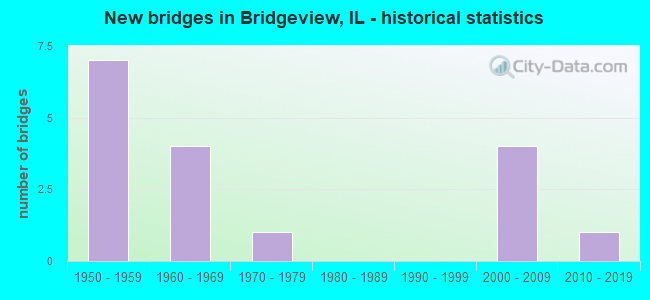
- New bridges - historical statistics
- 71950-1959
- 41960-1969
- 11970-1979
- 42000-2009
- 12010-2019

- Reconstructed bridges - Historical Statistics
- 21970-1979
- 01980-1989
- 01990-1999
- 12000-2009


- Bridge Condition - Deck
- 50.0%Good
- 12.5%Satisfactory
- 25.0%Fair
- 12.5%Poor

- Bridge Condition - Superstructure
- 12.5%Very good
- 12.5%Good
- 25.0%Satisfactory
- 37.5%Fair
- 12.5%Serious

- Bridge Condition - Substructure
- 75.0%Good
- 12.5%Satisfactory
- 12.5%Fair
Find on map >> Show street view
Structure Number: 16032, Location: 0.6 M N I-294 (Lat: 41.719419, Lng: -87.798647), Route carried "on" structure: State highway 43, Year Built: 1961, Year Reconstructed: 1983, Status: Open, Structure Length: 6.00m (19.69ft), Average Daily Traffic: 45,200 (year 2021), Truck Traffic: 11%, Average Future Daily Traffic: 31,724 (year 2032), Design Load: HS 20, Features Intersected: US 12,20 (95TH ST)
Minimum Vertical Clearance: 30+ m (98+ ft), Kilometerpoint: 23.818, Lanes on structure: 6, Lanes under structure: 6, Base Highway Network: Yes, Owner: State Highway Agency, Approaching Roadway Width: 26.3m (86.3ft), Skew: 30 degrees, Material/Design: Steel continuous, Design/Construction: Stringer/Multi-beam, Number Of Spans In Main Unit: 4, Length of Maximum Span: 18.1m (59.4ft), Curb-To-Curb Width: 26.3m (86.3ft), Out-to-Out Width: 32.3m (106.0ft)
Condition: Deck: Poor, Superstructure: Serious, Substructure: Fair, Operating Rating: 52.5 metric tons, Method Used To Determine Operating Rating: Load Factor (LF) rating reported by rating factor (RF) method using MS18 loading, Inventory Rating: 31.4 metric tons, Method Used To Determine Inventory Rating: Load Factor (LF) rating reported by rating factor (RF) method using MS18 loading, Structural Evaluation: High priority of corrective action, Deck Geometry: Equal to present minimum criteria, Underclear: High priority of corrective action, Approach Roadway Alignment: Equal to present desirable criteria, Designated Inspection Frequency: Every 12 months, Inspection Date: October 2021, Deck Structure Type: Concrete Cast-file-Place, Wearing Surface/Protective System: Wearing Surface: Latex Concrete
Find on map >> Show street view
Structure Number: 160519, Location: 0.6 M W IL 43 (Lat: 41.747869, Lng: -87.810025), Route carried "on" structure: Other road , Year Built: 1956, Year Reconstructed: 2011, Status: Open, Structure Length: 7.82m (25.66ft), Average Daily Traffic: 22,300 (year 2021), Truck Traffic: 14%, Average Future Daily Traffic: 42,900 (year 2037), Design Load: HS 20, Features Intersected: RR - CSXT, Facility Carried by Structure: 79TH ST
Minimum Vertical Clearance: 30+ m (98+ ft), Kilometerpoint: 2.688, Lanes on structure: 4, Lanes under structure: 4, Base Highway Network: Yes, Owner: State Highway Agency, Approaching Roadway Width: 16.2m (53.1ft), Skew: 30 degrees, Material/Design: Steel continuous, Design/Construction: Stringer/Multi-beam, Number Of Spans In Main Unit: 5, Length of Maximum Span: 18.9m (62.0ft), Curb or Sidewalk Widths: Left: 1.5m (4.9ft), Right: 1.5m (4.9ft), Curb-To-Curb Width: 16.7m (54.8ft), Out-to-Out Width: 21.2m (69.6ft)
Condition: Deck: Satisfactory, Superstructure: Satisfactory, Substructure: Good, Operating Rating: 86.8 metric tons, Method Used To Determine Operating Rating: Load Factor (LF) rating reported by rating factor (RF) method using MS18 loading, Inventory Rating: 51.8 metric tons, Method Used To Determine Inventory Rating: Load Factor (LF) rating reported by rating factor (RF) method using MS18 loading, Structural Evaluation: Equal to present minimum criteria, Deck Geometry: Somewhat better than minimum adequacy, Approach Roadway Alignment: Equal to present desirable criteria, Designated Inspection Frequency: Every 24 months, Inspection Date: May 2021, Deck Structure Type: Concrete Cast-file-Place, Wearing Surface/Protective System: Deck Protection: Epoxy Coated Reinforcing
Find on map >> Show street view
Structure Number: 16101, Location: 0.1 M NW IL 43 (Lat: 41.717161, Lng: -87.799431), Route carried "on" structure: Other road , Year Built: 1961, Year Reconstructed: 1984, Status: Open, Structure Length: 8.69m (28.51ft), Average Daily Traffic: 2,500 (year 2012), Average Future Daily Traffic: 15,862 (year 2032), Design Load: HS 20, Features Intersected: RR - CSXT & RICHARD, Facility Carried by Structure: US 12,20 EB RMP IL
Minimum Vertical Clearance: 30+ m (98+ ft), Kilometerpoint: 0.435, Lanes on structure: 1, Base Highway Network: Yes (Inventory Route: 20348043, Subroute: 10), Owner: State Highway Agency, Approaching Roadway Width: 10.4m (34.1ft), Skew: 5 degrees, Material/Design: Steel, Design/Construction: Stringer/Multi-beam, Number Of Spans In Main Unit: 4, Length of Maximum Span: 23.9m (78.4ft), Curb-To-Curb Width: 8.1m (26.6ft), Out-to-Out Width: 9.1m (29.9ft)
Condition: Deck: Fair, Superstructure: Fair, Substructure: Satisfactory, Operating Rating: 84.9 metric tons, Method Used To Determine Operating Rating: Load Factor (LF) rating reported by rating factor (RF) method using MS18 loading, Inventory Rating: 45.0 metric tons, Method Used To Determine Inventory Rating: Load Factor (LF) rating reported by rating factor (RF) method using MS18 loading, Structural Evaluation: Somewhat better than minimum adequacy, Deck Geometry: High priority of corrective action, Underclear: High priority of corrective action, Approach Roadway Alignment: Somewhat better than minimum adequacy, Designated Inspection Frequency: Every 24 months, Inspection Date: March 2021, Deck Structure Type: Concrete Cast-file-Place, Wearing Surface/Protective System: Deck Protection: Epoxy Coated Reinforcing
Find on map >> Show street view
Structure Number: 163243, Location: 0.6M.W.OF IL-43 (Lat: 41.733422, Lng: -87.808789), Route carried "on" structure: Other road , Year Built: 1971, Status: Open, Structure Length: 6.27m (20.57ft), Average Daily Traffic: 24,100 (year 2018), Truck Traffic: 6%, Average Future Daily Traffic: 23,278 (year 2032), Design Load: HS 20, Features Intersected: B&O,IHB RR, Facility Carried by Structure: 87TH ST.
Minimum Vertical Clearance: 30+ m (98+ ft), Kilometerpoint: 3.669, Lanes on structure: 4, Base Highway Network: Yes, Owner: County Highway Agency, Approaching Roadway Width: 15.8m (51.8ft), Skew: 30 degrees, Material/Design: Steel continuous, Design/Construction: Stringer/Multi-beam, Number Of Spans In Main Unit: 3, Length of Maximum Span: 22.9m (75.1ft), Curb or Sidewalk Widths: Left: 1.5m (4.9ft), Right: 1.5m (4.9ft), Curb-To-Curb Width: 15.8m (51.8ft), Out-to-Out Width: 20.7m (67.9ft)
Condition: Deck: Fair, Superstructure: Satisfactory, Substructure: Good, Operating Rating: 52.2 metric tons, Method Used To Determine Operating Rating: Load Factor (LF) rating reported by rating factor (RF) method using MS18 loading, Inventory Rating: 31.1 metric tons, Method Used To Determine Inventory Rating: Load Factor (LF) rating reported by rating factor (RF) method using MS18 loading, Structural Evaluation: Equal to present minimum criteria, Deck Geometry: Meets minimum limits, Underclear: Equal to present desirable criteria, Approach Roadway Alignment: Equal to present desirable criteria, Designated Inspection Frequency: Every 24 months, Inspection Date: January 2022, Deck Structure Type: Concrete Cast-file-Place, Wearing Surface/Protective System: Wearing Surface: Latex Concrete, Deck Protection: Cathodic Protection
Find on map >> Show street view
Structure Number: 16983, Location: 0.7 M NW ILL 7 P19 (Lat: 41.711522, Lng: -87.799058), Route carried "on" structure: Interstate 294, Year Built: 1958, Status: Open, Structure Length: 8.99m (29.49ft), Average Daily Traffic: 62,200 (year 2020), Truck Traffic: 19%, Average Future Daily Traffic: 50,625 (year 2032), Features Intersected: ILL 43 (HARLEM AVE)
Minimum Vertical Clearance: 30+ m (98+ ft), Kilometerpoint: 57.951, Lanes on structure: 3, Lanes under structure: 4, Base Highway Network: Yes, Toll: On toll road, Owner: State Toll Authority, Approaching Roadway Width: 15.8m (51.8ft), Skew: 4 degrees, Material/Design: Prestressed concrete, Design/Construction: Stringer/Multi-beam, Number Of Spans In Main Unit: 5, Length of Maximum Span: 18.0m (59.1ft), Curb-To-Curb Width: 14.3m (46.9ft), Out-to-Out Width: 18.6m (61.0ft)
Condition: Deck: Good, Superstructure: Fair, Substructure: Good, Operating Rating: 58.3 metric tons, Method Used To Determine Operating Rating: Load Factor (LF) rating reported by rating factor (RF) method using MS18 loading, Inventory Rating: 35.0 metric tons, Method Used To Determine Inventory Rating: Load Factor (LF) rating reported by rating factor (RF) method using MS18 loading, Structural Evaluation: Somewhat better than minimum adequacy, Deck Geometry: Meets minimum limits, Underclear: High priority of corrective action, Approach Roadway Alignment: Equal to present desirable criteria, Length Of Structure Improvement: 8.99m (29.49ft), Designated Inspection Frequency: Every 24 months, Inspection Date: June 2019, Bridge Improvement Cost: $1,134,000, Roadway Improvement Cost: $113,000, Total Project Cost: $1,701,000, Deck Structure Type: Concrete Cast-file-Place, Wearing Surface/Protective System: Wearing Surface: Bituminous, Membrane: Built-up
Find on map >> Show street view
Structure Number: 169831, Location: 0.7 M NW ILL 7 P19 (Lat: 41.711433, Lng: -87.798947), Route carried "on" structure: Interstate 294, Year Built: 1958, Status: Open, Structure Length: 8.99m (29.49ft), Average Daily Traffic: 62,200 (year 2020), Truck Traffic: 19%, Average Future Daily Traffic: 50,625 (year 2032), Features Intersected: ILL 43 (HARLEM AVE)
Minimum Vertical Clearance: 30+ m (98+ ft), Kilometerpoint: 57.967, Lanes on structure: 3, Lanes under structure: 4, Base Highway Network: Yes, Toll: On toll road, Owner: State Toll Authority, Approaching Roadway Width: 15.8m (51.8ft), Skew: 4 degrees, Material/Design: Prestressed concrete, Design/Construction: Stringer/Multi-beam, Number Of Spans In Main Unit: 5, Length of Maximum Span: 18.0m (59.1ft), Curb-To-Curb Width: 14.3m (46.9ft), Out-to-Out Width: 18.6m (61.0ft)
Condition: Deck: Good, Superstructure: Fair, Substructure: Good, Operating Rating: 58.3 metric tons, Method Used To Determine Operating Rating: Load Factor (LF) rating reported by rating factor (RF) method using MS18 loading, Inventory Rating: 35.0 metric tons, Method Used To Determine Inventory Rating: Load Factor (LF) rating reported by rating factor (RF) method using MS18 loading, Structural Evaluation: Somewhat better than minimum adequacy, Deck Geometry: Meets minimum limits, Underclear: High priority of corrective action, Approach Roadway Alignment: Equal to present desirable criteria, Length Of Structure Improvement: 8.99m (29.49ft), Designated Inspection Frequency: Every 24 months, Inspection Date: June 2019, Bridge Improvement Cost: $1,134,000, Roadway Improvement Cost: $113,000, Total Project Cost: $1,701,000, Deck Structure Type: Concrete Cast-file-Place, Wearing Surface/Protective System: Wearing Surface: Bituminous, Membrane: Built-up
Find on map >> Show street view
Structure Number: 16988, Location: .5MI N OF IL 34 (Lat: 41.717097, Lng: -87.805686), Route carried "on" structure: Interstate 294, Year Built: 2009, Status: Open, Structure Length: 4.17m (13.68ft), Average Daily Traffic: 62,200 (year 2020), Truck Traffic: 19%, Average Future Daily Traffic: 270,600 (year 2035), Design Load: HS 20, Features Intersected: US12-20 (95TH ST)
Minimum Vertical Clearance: 30+ m (98+ ft), Kilometerpoint: 56.969, Lanes on structure: 5, Lanes under structure: 4, Base Highway Network: Yes, Toll: On toll road, Owner: State Toll Authority, Approaching Roadway Width: 32.2m (105.6ft), Skew: 1 degrees, Material/Design: Prestressed concrete, Design/Construction: Stringer/Multi-beam, Number Of Spans In Main Unit: 2, Length of Maximum Span: 20.4m (66.9ft), Curb-To-Curb Width: 32.2m (105.6ft), Out-to-Out Width: 33.2m (108.9ft)
Condition: Deck: Good, Superstructure: Good, Substructure: Good, Operating Rating: 70.6 metric tons, Method Used To Determine Operating Rating: Load Factor (LF) rating reported by rating factor (RF) method using MS18 loading, Inventory Rating: 42.4 metric tons, Method Used To Determine Inventory Rating: Load Factor (LF) rating reported by rating factor (RF) method using MS18 loading, Structural Evaluation: Better than present minimum criteria, Deck Geometry: Superior to present desirable criteria, Underclear: High priority of corrective action, Approach Roadway Alignment: Equal to present desirable criteria, Designated Inspection Frequency: Every 24 months, Inspection Date: June 2019, Deck Structure Type: Concrete Cast-file-Place, Wearing Surface/Protective System: Wearing Surface: Bituminous, Membrane: Built-up
Find on map >> Show street view
Structure Number: 169881, Location: .5MI N OF IL34 (Lat: 41.716994, Lng: -87.805600), Route carried "on" structure: Interstate 294, Year Built: 2009, Status: Open, Structure Length: 4.17m (13.68ft), Average Daily Traffic: 62,200 (year 2020), Truck Traffic: 19%, Average Future Daily Traffic: 270,600 (year 2035), Design Load: HS 20, Features Intersected: US 12-20 (95TH ST)
Minimum Vertical Clearance: 30+ m (98+ ft), Kilometerpoint: 56.985, Lanes on structure: 4, Lanes under structure: 4, Base Highway Network: Yes, Toll: On toll road, Owner: State Toll Authority, Approaching Roadway Width: 26.5m (86.9ft), Skew: 1 degrees, Material/Design: Prestressed concrete, Design/Construction: Stringer/Multi-beam, Number Of Spans In Main Unit: 2, Length of Maximum Span: 20.4m (66.9ft), Curb-To-Curb Width: 26.5m (86.9ft), Out-to-Out Width: 27.5m (90.2ft)
Condition: Deck: Good, Superstructure: Very good, Substructure: Good, Operating Rating: 97.2 metric tons, Method Used To Determine Operating Rating: Load Factor (LF) rating reported by rating factor (RF) method using MS18 loading, Inventory Rating: 59.3 metric tons, Method Used To Determine Inventory Rating: Load Factor (LF) rating reported by rating factor (RF) method using MS18 loading, Structural Evaluation: Better than present minimum criteria, Deck Geometry: Superior to present desirable criteria, Underclear: High priority of corrective action, Approach Roadway Alignment: Equal to present desirable criteria, Designated Inspection Frequency: Every 24 months, Inspection Date: June 2019, Deck Structure Type: Concrete Cast-file-Place, Wearing Surface/Protective System: Wearing Surface: Bituminous, Membrane: Built-up
Find on map >> Show street view
Structure Number: 16032, Location: 0.6 M N I-294 (Lat: 41.719186, Lng: -87.798639), Route carried "under" structure: US 12, Year Built: 1961, Structure Length: 0. m, Average Daily Traffic: 16,600 (year 2021), Truck Traffic: 11%, Features Intersected: US 12,20 (95TH ST), Facility Carried by Structure: IL 43 (HARLEM AVE
Minimum Vertical Clearance: 4.42m (14.50ft), Kilometerpoint: 111.283, Lanes on structure: 6, Lanes under structure: 6, Material/Design: Steel continuous, Design/Construction: Stringer/Multi-beam, Length of Maximum Span: 18.1m (59.4ft)
Find on map >> Show street view
Structure Number: 160436, Location: 0.2 M W IL 43 (Lat: 41.718867, Lng: -87.801461), Route carried "under" structure: US 12, Year Built: 1961, Structure Length: 0. m, Average Daily Traffic: 16,600 (year 2021), Truck Traffic: 11%, Features Intersected: US 12,20 (95TH ST), Facility Carried by Structure: RR - IHB
Minimum Vertical Clearance: 4.42m (14.50ft), Kilometerpoint: 110.993, Lanes under structure: 5, Material/Design: Steel, Design/Construction: Girder and Floorbeam System, Length of Maximum Span: 24.6m (80.7ft)
Find on map >> Show street view
Structure Number: 160519, Location: 0.6 M W IL 43 (Lat: 41.747889, Lng: -87.809239), Route carried "under" structure: Other road , Year Built: 1956, Structure Length: 0. m, Average Daily Traffic: 475 (year 2018), Truck Traffic: 25%, Features Intersected: RR - CSXT, Facility Carried by Structure: 79TH ST
Minimum Vertical Clearance: 6.99m (22.93ft), Kilometerpoint: 0.435, Lanes on structure: 4, Lanes under structure: 2, Material/Design: Steel continuous, Design/Construction: Stringer/Multi-beam, Length of Maximum Span: 18.9m (62.0ft)
Find on map >> Show street view
Structure Number: 160519, Location: 0.6 M W IL 43 (Lat: 41.747881, Lng: -87.809639), Route carried "under" structure: Other road , Year Built: 1956, Structure Length: 0. m, Average Daily Traffic: 400 (year 2018), Truck Traffic: 38%, Features Intersected: RR - CSXT, Facility Carried by Structure: 79TH ST
Minimum Vertical Clearance: 6.99m (22.93ft), Kilometerpoint: 0.418, Lanes on structure: 4, Lanes under structure: 2, Material/Design: Steel continuous, Design/Construction: Stringer/Multi-beam, Length of Maximum Span: 18.9m (62.0ft)
Find on map >> Show street view
Structure Number: 167721, Location: .5M W of IL43 (Lat: 41.762489, Lng: -87.809981), Route carried "under" structure: Other road , Year Built: 2013, Structure Length: 0. m, Average Daily Traffic: 9,900 (year 2018), Truck Traffic: 20%, Features Intersected: 71st. St., Facility Carried by Structure: CSX RR
Minimum Vertical Clearance: 4.50m (14.76ft), Kilometerpoint: 0.805, Lanes under structure: 2, Material/Design: Prestressed concrete, Design/Construction: Box Beam or Girders - Single/Spread, Length of Maximum Span: 0.0m
Find on map >> Show street view
Structure Number: 16983, Location: 0.7 M NW ILL 7 P19 (Lat: 41.711281, Lng: -87.798356), Route carried "under" structure: State highway 43, Year Built: 1958, Structure Length: 0. m, Average Daily Traffic: 38,600 (year 2021), Truck Traffic: 7%, Features Intersected: ILL 43 (HARLEM AVE), Facility Carried by Structure: I-294 NB
Minimum Vertical Clearance: 7.67m (25.16ft), Kilometerpoint: 22.884, Lanes on structure: 3, Lanes under structure: 4, Toll: On toll road, Material/Design: Prestressed concrete, Design/Construction: Stringer/Multi-beam, Length of Maximum Span: 18.0m (59.1ft)
Find on map >> Show street view
Structure Number: 169831, Location: 0.7 M NW ILL 7 P19 (Lat: 41.710953, Lng: -87.798344), Route carried "under" structure: State highway 43, Year Built: 1958, Structure Length: 0. m, Average Daily Traffic: 41,100 (year 2021), Truck Traffic: 4%, Features Intersected: ILL 43 (HARLEM AVE), Facility Carried by Structure: I-294 SB
Minimum Vertical Clearance: 7.67m (25.16ft), Kilometerpoint: 22.852, Lanes on structure: 3, Lanes under structure: 4, Toll: On toll road, Material/Design: Prestressed concrete, Design/Construction: Stringer/Multi-beam, Length of Maximum Span: 18.0m (59.1ft)
Find on map >> Show street view
Structure Number: 16988, Location: .5MI N OF IL 34 (Lat: 41.718694, Lng: -87.807006), Route carried "under" structure: US 12, Year Built: 2009, Structure Length: 0. m, Average Daily Traffic: 16,600 (year 2021), Truck Traffic: 11%, Features Intersected: US12-20 (95TH ST), Facility Carried by Structure: I-294EB
Minimum Vertical Clearance: 4.62m (15.16ft), Kilometerpoint: 110.607, Lanes on structure: 5, Lanes under structure: 4, Toll: On toll road, Material/Design: Prestressed concrete, Design/Construction: Stringer/Multi-beam, Length of Maximum Span: 20.4m (66.9ft)
Find on map >> Show street view
Structure Number: 169881, Location: .5MI N OF IL34 (Lat: 41.718700, Lng: -87.806728), Route carried "under" structure: US 12, Year Built: 2009, Structure Length: 0. m, Average Daily Traffic: 16,600 (year 2021), Truck Traffic: 11%, Features Intersected: US 12-20 (95TH ST), Facility Carried by Structure: I-294WB
Minimum Vertical Clearance: 4.62m (15.16ft), Kilometerpoint: 110.639, Lanes on structure: 4, Lanes under structure: 4, Toll: On toll road, Material/Design: Prestressed concrete, Design/Construction: Stringer/Multi-beam, Length of Maximum Span: 20.4m (66.9ft)