Bridge Statistics for Bridgman, Michigan (MI)
Condition, Traffic, Stress, Structural Evaluation, Project Costs
- National Bridge Inventory (NBI) Statistics
- 11Number of bridges
- 105ft / 31.8mTotal length
- 176,746Total average daily traffic
- 51,433Total average daily truck traffic
- National Bridge Inventory (NBI) Registered Bridges for Bridgman
- No street view available for this location
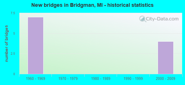
- New bridges - historical statistics
- 71960-1969
- 42000-2009


- Bridge Condition - Deck
- 50.0%Good
- 50.0%Satisfactory

- Bridge Condition - Superstructure
- 25.0%Good
- 75.0%Satisfactory

- Bridge Condition - Substructure
- 50.0%Good
- 50.0%Satisfactory
Find on map >> Show street view
Structure Number: 796, Location: 7.7 MI NE OF BRIDGEMAN (Lat: 41.977950, Lng: -86.544408), Route carried "on" structure: Other road 10, Year Built: 1969, Status: Open, Structure Length: 11.95m (39.21ft), Average Daily Traffic: 70 (year 1988), Average Future Daily Traffic: 80 (year 2008), Design Load: HS 20, Features Intersected: I-94, Facility Carried by Structure: MI & IN ELEC ROAD
Minimum Vertical Clearance: 30.48m (100.00ft), Kilometerpoint: 0.068, Lanes on structure: 2, Lanes under structure: 6, Owner: State Highway Agency, Approaching Roadway Width: 8.7m (28.5ft), Material/Design: Steel, Design/Construction: Girder and Floorbeam System, Number Of Spans In Main Unit: 5, Length of Maximum Span: 28.9m (94.8ft), Curb or Sidewalk Widths: Left: 0.2m (0.7ft), Right: 0.2m (0.7ft), Curb-To-Curb Width: 8.7m (28.5ft), Out-to-Out Width: 9.8m (32.2ft)
Condition: Deck: Satisfactory, Superstructure: Satisfactory, Substructure: Satisfactory, Operating Rating: 56.7 metric tons, Method Used To Determine Operating Rating: Load Factor (LF) rating reported by rating factor (RF) method using MS18 loading, Inventory Rating: 34.0 metric tons, Method Used To Determine Inventory Rating: Load Factor (LF) rating reported by rating factor (RF) method using MS18 loading, Structural Evaluation: Equal to present minimum criteria, Deck Geometry: Better than present minimum criteria, Underclear: Better than present minimum criteria, Approach Roadway Alignment: Better than present minimum criteria, Designated Inspection Frequency: Every 24 months, Critical Feature Inspection Frequency: Every 15 months, Inspection Date: August 2020, Critical Feature Inspection Date: September 2021, Deck Structure Type: Concrete Cast-file-Place, Wearing Surface/Protective System: Wearing Surface: Monolithic Concrete
Find on map >> Show street view
Structure Number: 81, Location: S LTS OF BRIDGEMAN (Lat: 41.930197, Lng: -86.571439), Route carried "on" structure: Interstate 94, Year Built: 2004, Status: Open, Structure Length: 7.32m (24.02ft), Average Daily Traffic: 18,964 (year 2007), Truck Traffic: 31%, Average Future Daily Traffic: 22,772 (year 2018), Design Load: HS 25 or greater, Features Intersected: OLD US-12(RED ARROW HWY)
Minimum Vertical Clearance: 30.48m (100.00ft), Kilometerpoint: 25.044, Lanes on structure: 4, Lanes under structure: 6, Base Highway Network: Yes (Inventory Route: 136, Subroute: 4), Owner: State Highway Agency, Approaching Roadway Width: 16.2m (53.1ft), Skew: 5 degrees, Material/Design: Prestressed concrete, Design/Construction: Box Beam or Girders - Multiple, Number Of Spans In Main Unit: 2, Length of Maximum Span: 35.2m (115.5ft), Curb-To-Curb Width: 22.9m (75.1ft), Out-to-Out Width: 23.9m (78.4ft)
Condition: Deck: Good, Superstructure: Satisfactory, Substructure: Good, Inventory Rating: 52.8 metric tons, Method Used To Determine Inventory Rating: Load Factor (LF), Structural Evaluation: Equal to present minimum criteria, Deck Geometry: Superior to present desirable criteria, Underclear: Equal to present minimum criteria, Approach Roadway Alignment: Equal to present minimum criteria, Designated Inspection Frequency: Every 24 months, Inspection Date: July 2020, Deck Structure Type: Concrete Cast-file-Place, Wearing Surface/Protective System: Wearing Surface: Monolithic Concrete, Deck Protection: Epoxy Coated Reinforcing
Find on map >> Show street view
Structure Number: 811, Location: S LTS OF BRIDGEMAN (Lat: 41.929836, Lng: -86.571658), Route carried "on" structure: Interstate 94, Year Built: 2004, Status: Open, Structure Length: 7.32m (24.02ft), Average Daily Traffic: 18,964 (year 2007), Truck Traffic: 31%, Average Future Daily Traffic: 22,772 (year 2018), Design Load: HS 25 or greater, Features Intersected: OLD US-12(RED ARROW HWY)
Minimum Vertical Clearance: 30.48m (100.00ft), Kilometerpoint: 25.000, Lanes on structure: 4, Lanes under structure: 6, Base Highway Network: Yes (Inventory Route: 136, Subroute: 2), Owner: State Highway Agency, Approaching Roadway Width: 16.2m (53.1ft), Skew: 5 degrees, Material/Design: Prestressed concrete, Design/Construction: Box Beam or Girders - Multiple, Number Of Spans In Main Unit: 2, Length of Maximum Span: 35.2m (115.5ft), Curb-To-Curb Width: 22.9m (75.1ft), Out-to-Out Width: 23.9m (78.4ft)
Condition: Deck: Satisfactory, Superstructure: Satisfactory, Substructure: Good, Inventory Rating: 52.8 metric tons, Method Used To Determine Inventory Rating: Load Factor (LF), Structural Evaluation: Equal to present minimum criteria, Deck Geometry: Superior to present desirable criteria, Underclear: Equal to present minimum criteria, Approach Roadway Alignment: Equal to present minimum criteria, Designated Inspection Frequency: Every 24 months, Inspection Date: July 2020, Deck Structure Type: Concrete Cast-file-Place, Wearing Surface/Protective System: Wearing Surface: Monolithic Concrete, Deck Protection: Epoxy Coated Reinforcing
Find on map >> Show street view
Structure Number: 813, Location: 0.5 MI E OF RED ARROW HWY (Lat: 41.943089, Lng: -86.567172), Route carried "on" structure: Interstate 94, Year Built: 1961, Year Reconstructed: 1998, Status: Open, Structure Length: 5.21m (17.09ft), Average Daily Traffic: 18,964 (year 2007), Truck Traffic: 31%, Average Future Daily Traffic: 22,772 (year 2018), Design Load: HS 20+Mod, Features Intersected: LAKE STREET
Minimum Vertical Clearance: 30.48m (100.00ft), Kilometerpoint: 26.573, Lanes on structure: 3, Lanes under structure: 2, Base Highway Network: Yes (Inventory Route: 136, Subroute: 2), Owner: State Highway Agency, Approaching Roadway Width: 15.5m (50.9ft), Skew: 1 degrees, Material/Design: Prestressed concrete, Design/Construction: Stringer/Multi-beam, Number Of Spans In Main Unit: 3, Length of Maximum Span: 17.3m (56.8ft), Curb-To-Curb Width: 17.7m (58.1ft), Out-to-Out Width: 18.6m (61.0ft)
Condition: Deck: Good, Superstructure: Good, Substructure: Satisfactory, Operating Rating: 63.5 metric tons, Method Used To Determine Operating Rating: Load Factor (LF) rating reported by rating factor (RF) method using MS18 loading, Inventory Rating: 31.8 metric tons, Method Used To Determine Inventory Rating: Load Factor (LF) rating reported by rating factor (RF) method using MS18 loading, Structural Evaluation: Equal to present minimum criteria, Deck Geometry: Better than present minimum criteria, Underclear: Better than present minimum criteria, Approach Roadway Alignment: Equal to present desirable criteria, Designated Inspection Frequency: Every 24 months, Inspection Date: May 2020, Deck Structure Type: Concrete Cast-file-Place, Wearing Surface/Protective System: Wearing Surface: Monolithic Concrete, Deck Protection: Epoxy Coated Reinforcing
Find on map >> Show street view
Structure Number: 796, Location: 7.7 MI NE OF BRIDGEMAN (Lat: 41.977950, Lng: -86.544408), Route carried "under" structure: Interstate 94, Year Built: 1969, Structure Length: 0. m, Average Daily Traffic: 37,928 (year 2007), Truck Traffic: 27%, Features Intersected: I-94, Facility Carried by Structure: MI & IN ELEC ROAD
Minimum Vertical Clearance: 7.57m (24.84ft), Kilometerpoint: 30.872, Lanes on structure: 2, Lanes under structure: 6, Material/Design: Steel, Design/Construction: Girder and Floorbeam System, Length of Maximum Span: 28.9m (94.8ft)
Find on map >> Show street view
Structure Number: 81, Location: S LTS OF BRIDGEMAN (Lat: 41.930197, Lng: -86.571439), Route carried "under" structure: City street 1105, Year Built: 2004, Structure Length: 0. m, Average Daily Traffic: 1,500 (year 0000), Features Intersected: OLD US-12(RED ARROW HWY), Facility Carried by Structure: I-94 EB
Minimum Vertical Clearance: 4.55m (14.93ft), Kilometerpoint: 27.553, Lanes on structure: 4, Lanes under structure: 6, Material/Design: Prestressed concrete, Design/Construction: Box Beam or Girders - Multiple, Length of Maximum Span: 35.2m (115.5ft)
Find on map >> Show street view
Structure Number: 811, Location: S LTS OF BRIDGEMAN (Lat: 41.929836, Lng: -86.571658), Route carried "under" structure: City street 1105, Year Built: 2004, Structure Length: 0. m, Average Daily Traffic: 1,500 (year 0000), Features Intersected: OLD US-12(RED ARROW HWY), Facility Carried by Structure: I-94 WB
Minimum Vertical Clearance: 4.65m (15.26ft), Kilometerpoint: 27.508, Lanes on structure: 4, Lanes under structure: 6, Material/Design: Prestressed concrete, Design/Construction: Box Beam or Girders - Multiple, Length of Maximum Span: 35.2m (115.5ft)
Find on map >> Show street view
Structure Number: 812, Location: 0.5 MI E OF RED ARROW HWY (Lat: 41.943067, Lng: -86.566825), Route carried "under" structure: City street , Year Built: 1961, Structure Length: 0. m, Average Daily Traffic: 1,500 (year 0000), Features Intersected: LAKE STREET, Facility Carried by Structure: I-94 EB
Minimum Vertical Clearance: 7.54m (24.74ft), Kilometerpoint: 0.283, Lanes on structure: 3, Lanes under structure: 2, Material/Design: Prestressed concrete, Design/Construction: Stringer/Multi-beam, Length of Maximum Span: 17.3m (56.8ft)
Find on map >> Show street view
Structure Number: 813, Location: 0.5 MI E OF RED ARROW HWY (Lat: 41.943089, Lng: -86.567172), Route carried "under" structure: City street , Year Built: 1961, Structure Length: 0. m, Average Daily Traffic: 1,500 (year 0000), Truck Traffic: 3%, Features Intersected: LAKE STREET, Facility Carried by Structure: I-94 WB
Minimum Vertical Clearance: 7.54m (24.74ft), Kilometerpoint: 0.312, Lanes on structure: 3, Lanes under structure: 2, Material/Design: Prestressed concrete, Design/Construction: Stringer/Multi-beam, Length of Maximum Span: 17.3m (56.8ft)
Find on map >> Show street view
Structure Number: 814, Location: 1.0 MI N OF BRIDGEMAN (Lat: 41.968342, Lng: -86.550597), Route carried "under" structure: Interstate 94, Year Built: 1961, Structure Length: 0. m, Average Daily Traffic: 37,928 (year 2007), Truck Traffic: 31%, Features Intersected: I-94, Facility Carried by Structure: LIVINGSTON ROAD
Minimum Vertical Clearance: 5.36m (17.59ft), Kilometerpoint: 29.689, Lanes on structure: 2, Lanes under structure: 6, Material/Design: Steel, Design/Construction: Stringer/Multi-beam, Length of Maximum Span: 24.0m (78.7ft)
Find on map >> Show street view
Structure Number: 826, Location: 7.7 MI NE OF BRIDGEMAN (Lat: 41.977889, Lng: -86.544450), Route carried "under" structure: Interstate 94, Year Built: 1969, Structure Length: 0. m, Average Daily Traffic: 37,928 (year 2007), Truck Traffic: 31%, Features Intersected: I-94, Facility Carried by Structure: MI & IN ELEC CO RR
Minimum Vertical Clearance: 7.54m (24.74ft), Kilometerpoint: 30.863, Lanes under structure: 8, Material/Design: Steel, Design/Construction: Girder and Floorbeam System, Length of Maximum Span: 28.9m (94.8ft)