Bridge Statistics for Bright, Indiana (IN)
Condition, Traffic, Stress, Structural Evaluation, Project Costs
- National Bridge Inventory (NBI) Statistics
- 41Number of bridges
- 581ft / 177mTotal length
- $2,581,000Total costs
- 171,244Total average daily traffic
- 19,401Total average daily truck traffic
- National Bridge Inventory (NBI) Registered Bridges for Bright
- No street view available for this location
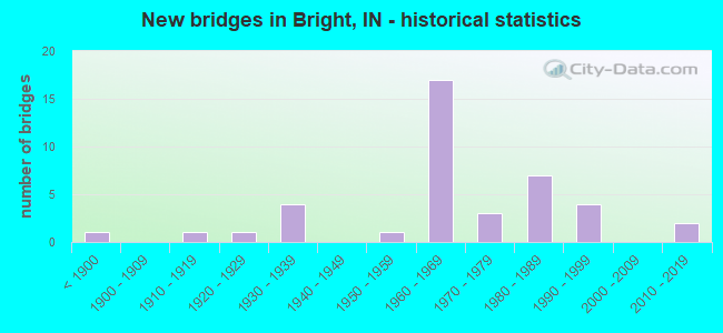
- New bridges - historical statistics
- 1Before 1900
- 11910-1919
- 11920-1929
- 41930-1939
- 11950-1959
- 171960-1969
- 31970-1979
- 71980-1989
- 41990-1999
- 22010-2019

- Reconstructed bridges - Historical Statistics
- 11960-1969
- 11970-1979
- 31980-1989
- 91990-1999
- 32000-2009
- 32010-2019


- Bridge Condition - Deck
- 3.6%Excellent
- 3.6%Very good
- 25.0%Good
- 50.0%Satisfactory
- 10.7%Fair
- 7.1%Poor

- Bridge Condition - Superstructure
- 3.6%Excellent
- 3.6%Very good
- 28.6%Good
- 35.7%Satisfactory
- 17.9%Fair
- 10.7%Poor

- Bridge Condition - Substructure
- 3.6%Excellent
- 25.0%Good
- 50.0%Satisfactory
- 7.1%Fair
- 14.3%Poor

- Bridge Condition - Channel
- 3.6%Excellent
- 3.6%Very good
- 21.4%Good
- 32.1%Satisfactory
- 35.7%Fair
- 3.6%Poor

- Bridge Condition - Culverts
- 20.0%Very good
- 20.0%Good
- 20.0%Satisfactory
- 20.0%Fair
- 20.0%Serious
Find on map >> Show street view
Structure Number: 3, Location: 07.16 S I-74 (Lat: 39.194869, Lng: -84.908133), Route carried "on" structure: State highway 1, Year Built: 1932, Year Reconstructed: 1984, Status: Open, Structure Length: 1.59m (5.22ft), Average Daily Traffic: 4,241 (year 2014), Truck Traffic: 10%, Average Future Daily Traffic: 4,183 (year 2031), Design Load: H 20, Features Intersected: BRUSHY FORK
Minimum Vertical Clearance: 30+ m (98+ ft), Kilometerpoint: 11.861, Lanes on structure: 2, Owner: State Highway Agency, Approaching Roadway Width: 14.0m (45.9ft), Material/Design: Concrete, Design/Construction: Arch - Deck, Number Of Spans In Main Unit: 1, Length of Maximum Span: 15.2m (49.9ft), Curb or Sidewalk Widths: Left: 0.1m (0.3ft), Right: 0.1m (0.3ft), Curb-To-Curb Width: 13.4m (44.0ft), Out-to-Out Width: 14.4m (47.2ft)
Condition: Deck: Satisfactory, Superstructure: Satisfactory, Substructure: Good, Channel: Good, Operating Rating: 92.7 metric tons, Method Used To Determine Operating Rating: Field evaluation and documented engineering judgment, Inventory Rating: 55.5 metric tons, Method Used To Determine Inventory Rating: Field evaluation and documented engineering judgment, Structural Evaluation: Equal to present minimum criteria, Deck Geometry: Better than present minimum criteria, Waterway Adequacy: Equal to present desirable criteria, Approach Roadway Alignment: Equal to present desirable criteria, Designated Inspection Frequency: Every 24 months, Inspection Date: July 2021, Deck Structure Type: Concrete Cast-file-Place, Wearing Surface/Protective System: Wearing Surface: Bituminous
Find on map >> Show street view
Structure Number: 4, Location: 05.70 S I-74 (Lat: 39.204511, Lng: -84.927064), Route carried "on" structure: State highway 1, Year Built: 1932, Year Reconstructed: 1973, Status: Open, Structure Length: 1.19m (3.90ft), Average Daily Traffic: 4,241 (year 2014), Truck Traffic: 10%, Average Future Daily Traffic: 4,195 (year 2033), Design Load: H 20, Features Intersected: SLAB CAMP CREEK
Minimum Vertical Clearance: 30+ m (98+ ft), Kilometerpoint: 14.211, Lanes on structure: 2, Owner: State Highway Agency, Approaching Roadway Width: 8.5m (27.9ft), Skew: 2 degrees, Material/Design: Concrete, Design/Construction: Culvert, Number Of Spans In Main Unit: 1, Length of Maximum Span: 11.0m (36.1ft), Curb-To-Curb Width: 13.4m (44.0ft), Out-to-Out Width: 13.4m (44.0ft)
Condition: Channel: Fair, Culverts: Satisfactory, Inventory Rating: 88.2 metric tons, Method Used To Determine Inventory Rating: Field evaluation and documented engineering judgment, Structural Evaluation: Equal to present minimum criteria, Deck Geometry: Better than present minimum criteria, Waterway Adequacy: Better than present minimum criteria, Approach Roadway Alignment: Equal to present desirable criteria, Designated Inspection Frequency: Every 24 months, Inspection Date: July 2021
Find on map >> Show street view
Structure Number: 1753, Location: 00.95 W US 52 (Lat: 39.277339, Lng: -84.882881), Route carried "on" structure: State highway 46, Year Built: 1937, Year Reconstructed: 1985, Status: Open, Structure Length: 7.47m (24.51ft), Average Daily Traffic: 1,641 (year 2004), Truck Traffic: 10%, Average Future Daily Traffic: 2,756 (year 2033), Design Load: H 20, Features Intersected: LOGAN CREEK
Minimum Vertical Clearance: 30+ m (98+ ft), Kilometerpoint: 16.834, Lanes on structure: 2, Owner: State Highway Agency, Approaching Roadway Width: 12.2m (40.0ft), Skew: 3 degrees, Material/Design: Steel continuous, Design/Construction: Stringer/Multi-beam, Number Of Spans In Main Unit: 4, Length of Maximum Span: 20.1m (65.9ft), Curb-To-Curb Width: 9.8m (32.2ft), Out-to-Out Width: 10.5m (34.4ft)
Condition: Deck: Fair, Superstructure: Good, Substructure: Satisfactory, Channel: Fair, Operating Rating: 58.4 metric tons, Method Used To Determine Operating Rating: Load Factor (LF), Inventory Rating: 35.0 metric tons, Method Used To Determine Inventory Rating: Load Factor (LF), Structural Evaluation: Equal to present minimum criteria, Deck Geometry: Somewhat better than minimum adequacy, Waterway Adequacy: Better than present minimum criteria, Approach Roadway Alignment: Equal to present desirable criteria, Designated Inspection Frequency: Every 24 months, Inspection Date: January 2021, Deck Structure Type: Concrete Cast-file-Place, Wearing Surface/Protective System: Wearing Surface: Monolithic Concrete, Deck Protection: Epoxy Coated Reinforcing
Find on map >> Show street view
Structure Number: 1754, Location: 00.44 W US 52 (Lat: 39.280039, Lng: -84.874031), Route carried "on" structure: State highway 46, Year Built: 1937, Year Reconstructed: 1985, Status: Open, Structure Length: 27.01m (88.62ft), Average Daily Traffic: 2,681 (year 2004), Truck Traffic: 10%, Average Future Daily Traffic: 4,505 (year 2033), Design Load: HS 20, Features Intersected: WHITEWATER RIVER
Minimum Vertical Clearance: 4.52m (14.83ft), Kilometerpoint: 17.655, Lanes on structure: 2, Owner: State Highway Agency, Approaching Roadway Width: 8.5m (27.9ft), Material/Design: Steel, Design/Construction: Truss - Thru, Number Of Spans In Main Unit: 5, Length of Maximum Span: 53.3m (174.9ft), Curb or Sidewalk Widths: Left: 0.2m (0.7ft), Right: 0.2m (0.7ft), Curb-To-Curb Width: 7.3m (24.0ft), Out-to-Out Width: 7.6m (24.9ft)
Condition: Deck: Fair, Superstructure: Poor, Substructure: Satisfactory, Channel: Good, Operating Rating: 37.4 metric tons, Method Used To Determine Operating Rating: Load Factor (LF), Inventory Rating: 22.4 metric tons, Method Used To Determine Inventory Rating: Load Factor (LF), Structural Evaluation: Meets minimum limits, Deck Geometry: High priority of replacement, Waterway Adequacy: Equal to present minimum criteria, Approach Roadway Alignment: Equal to present minimum criteria, Designated Inspection Frequency: Every 12 months, Critical Feature Inspection Frequency: Every 24 months, Underwater Inspection Frequency: Every 60 months, Other Special Inspection Frequency: Every 12 months, Inspection Date: September 2021, Critical Feature Inspection Date: September 2020, Underwater Inspection Date: July 2018, Other Special Inspection Date: September 2021, Deck Structure Type: Concrete Cast-file-Place, Wearing Surface/Protective System: Wearing Surface: Latex Concrete
Find on map >> Show street view
Structure Number: 1755, Location: 00.05 W US 52 (Lat: 39.282011, Lng: -84.867561), Route carried "on" structure: State highway 46, Year Built: 1986, Status: Open, Structure Length: 0.76m (2.49ft), Average Daily Traffic: 2,681 (year 2004), Truck Traffic: 10%, Average Future Daily Traffic: 4,483 (year 2031), Features Intersected: INDIANA & OHIO RR
Minimum Vertical Clearance: 30+ m (98+ ft), Kilometerpoint: 18.282, Lanes on structure: 2, Owner: State Highway Agency, Approaching Roadway Width: 14.0m (45.9ft), Skew: 1 degrees, Material/Design: Steel, Design/Construction: Culvert, Number Of Spans In Main Unit: 1, Length of Maximum Span: 7.6m (24.9ft), Curb-To-Curb Width: 14.1m (46.3ft), Out-to-Out Width: 14.1m (46.3ft)
Condition: Culverts: Good, Operating Rating: 97.2 metric tons, Method Used To Determine Operating Rating: Load and Resistance Factor Rating (LRFR) rating reported by rating factor(RF) method using HL-93 loadings, Inventory Rating: 97.2 metric tons, Method Used To Determine Inventory Rating: Load and Resistance Factor Rating (LRFR) rating reported by rating factor(RF) method using HL-93 loadings, Structural Evaluation: Better than present minimum criteria, Deck Geometry: Superior to present desirable criteria, Underclear: Meets minimum limits, Approach Roadway Alignment: Equal to present desirable criteria, Designated Inspection Frequency: Every 24 months, Inspection Date: January 2021
Find on map >> Show street view
Structure Number: 4532, Location: 01.23 W US 52 (Lat: 39.275711, Lng: -84.882958), Route carried "on" structure: Interstate 74, Year Built: 1962, Year Reconstructed: 1995, Status: Open, Structure Length: 4.15m (13.62ft), Average Daily Traffic: 14,715 (year 2004), Truck Traffic: 10%, Average Future Daily Traffic: 28,007 (year 2031), Design Load: HS 20+Mod, Features Intersected: WHITE'S HILL ROAD
Minimum Vertical Clearance: 30+ m (98+ ft), Kilometerpoint: 269.823, Lanes on structure: 2, Lanes under structure: 2, Base Highway Network: Yes (, Subroute: 1), Owner: State Highway Agency, Approaching Roadway Width: 12.2m (40.0ft), Material/Design: Steel continuous, Design/Construction: Stringer/Multi-beam, Number Of Spans In Main Unit: 3, Length of Maximum Span: 16.2m (53.1ft), Curb-To-Curb Width: 12.2m (40.0ft), Out-to-Out Width: 13.1m (43.0ft)
Condition: Deck: Good, Superstructure: Satisfactory, Substructure: Good, Operating Rating: 54.1 metric tons, Method Used To Determine Operating Rating: Load and Resistance Factor Rating (LRFR) rating reported by rating factor(RF) method using HL-93 loadings, Inventory Rating: 41.8 metric tons, Method Used To Determine Inventory Rating: Load and Resistance Factor Rating (LRFR) rating reported by rating factor(RF) method using HL-93 loadings, Structural Evaluation: Equal to present minimum criteria, Deck Geometry: Better than present minimum criteria, Underclear: Meets minimum limits, Approach Roadway Alignment: Equal to present desirable criteria, Designated Inspection Frequency: Every 24 months, Inspection Date: June 2020, Deck Structure Type: Concrete Cast-file-Place, Wearing Surface/Protective System: Wearing Surface: Epoxy Overlay, Deck Protection: Epoxy Coated Reinforcing
Find on map >> Show street view
Structure Number: 4533, Location: 01.23 W US 52 (Lat: 39.276039, Lng: -84.883011), Route carried "on" structure: Interstate 74, Year Built: 1962, Year Reconstructed: 1995, Status: Open, Structure Length: 3.63m (11.91ft), Average Daily Traffic: 14,715 (year 2004), Truck Traffic: 10%, Average Future Daily Traffic: 28,007 (year 2031), Design Load: HS 20+Mod, Features Intersected: WHITE'S HILL ROAD
Minimum Vertical Clearance: 30+ m (98+ ft), Kilometerpoint: 269.823, Lanes on structure: 2, Lanes under structure: 2, Base Highway Network: Yes (, Subroute: 1), Owner: State Highway Agency, Approaching Roadway Width: 12.2m (40.0ft), Skew: 1 degrees, Material/Design: Steel continuous, Design/Construction: Stringer/Multi-beam, Number Of Spans In Main Unit: 3, Length of Maximum Span: 13.9m (45.6ft), Curb-To-Curb Width: 12.2m (40.0ft), Out-to-Out Width: 13.1m (43.0ft)
Condition: Deck: Good, Superstructure: Good, Substructure: Good, Operating Rating: 58.3 metric tons, Method Used To Determine Operating Rating: Load and Resistance Factor Rating (LRFR) rating reported by rating factor(RF) method using HL-93 loadings, Inventory Rating: 45.0 metric tons, Method Used To Determine Inventory Rating: Load and Resistance Factor Rating (LRFR) rating reported by rating factor(RF) method using HL-93 loadings, Structural Evaluation: Better than present minimum criteria, Deck Geometry: Better than present minimum criteria, Underclear: Somewhat better than minimum adequacy, Approach Roadway Alignment: Equal to present desirable criteria, Designated Inspection Frequency: Every 24 months, Inspection Date: June 2020, Deck Structure Type: Concrete Cast-file-Place, Wearing Surface/Protective System: Wearing Surface: Epoxy Overlay, Deck Protection: Epoxy Coated Reinforcing
Find on map >> Show street view
Structure Number: 4534, Location: 00.71 W US 52 (Lat: 39.275381, Lng: -84.873411), Route carried "on" structure: Interstate 74, Year Built: 1962, Year Reconstructed: 1995, Status: Open, Structure Length: 28.77m (94.39ft), Average Daily Traffic: 14,727 (year 2004), Truck Traffic: 10%, Average Future Daily Traffic: 28,593 (year 2033), Design Load: HS 20, Features Intersected: WHITEWATER RIV, CR & RD
Minimum Vertical Clearance: 30+ m (98+ ft), Kilometerpoint: 270.659, Lanes on structure: 2, Lanes under structure: 2, Base Highway Network: Yes (, Subroute: 1), Owner: State Highway Agency, Approaching Roadway Width: 10.1m (33.1ft), Material/Design: Steel continuous, Design/Construction: Girder and Floorbeam System, Number Of Spans In Main Unit: 5, Number Of Approach Spans: 2, Length of Maximum Span: 67.1m (220.1ft), Curb-To-Curb Width: 10.2m (33.5ft), Out-to-Out Width: 11.1m (36.4ft)
Condition: Deck: Satisfactory, Superstructure: Fair, Substructure: Satisfactory, Channel: Satisfactory, Operating Rating: 26.6 metric tons, Method Used To Determine Operating Rating: Load and Resistance Factor Rating (LRFR) rating reported by rating factor(RF) method using HL-93 loadings, Inventory Rating: 20.4 metric tons, Method Used To Determine Inventory Rating: Load and Resistance Factor Rating (LRFR) rating reported by rating factor(RF) method using HL-93 loadings, Structural Evaluation: Somewhat better than minimum adequacy, Deck Geometry: Meets minimum limits, Underclear: Meets minimum limits, Waterway Adequacy: Better than present minimum criteria, Approach Roadway Alignment: Equal to present desirable criteria, Designated Inspection Frequency: Every 24 months, Critical Feature Inspection Frequency: Every 24 months, Underwater Inspection Frequency: Every 36 months, Other Special Inspection Frequency: Every 12 months, Inspection Date: May 2021, Critical Feature Inspection Date: May 2021, Underwater Inspection Date: October 2021, Other Special Inspection Date: May 2021, Deck Structure Type: Concrete Cast-file-Place, Wearing Surface/Protective System: Wearing Surface: Monolithic Concrete, Deck Protection: Epoxy Coated Reinforcing
Find on map >> Show street view
Structure Number: 4535, Location: 00.71 W US 52 (Lat: 39.275611, Lng: -84.873469), Route carried "on" structure: Interstate 74, Year Built: 1962, Year Reconstructed: 1995, Status: Open, Structure Length: 29.50m (96.78ft), Average Daily Traffic: 14,715 (year 2004), Truck Traffic: 10%, Average Future Daily Traffic: 29,701 (year 2033), Design Load: HS 20, Features Intersected: WHITEWATER RIV, CR & RD
Minimum Vertical Clearance: 30+ m (98+ ft), Kilometerpoint: 270.659, Lanes on structure: 2, Lanes under structure: 2, Base Highway Network: Yes (, Subroute: 1), Owner: State Highway Agency, Approaching Roadway Width: 9.4m (30.8ft), Material/Design: Steel continuous, Design/Construction: Girder and Floorbeam System, Number Of Spans In Main Unit: 5, Number Of Approach Spans: 3, Length of Maximum Span: 67.1m (220.1ft), Curb-To-Curb Width: 10.2m (33.5ft), Out-to-Out Width: 11.1m (36.4ft)
Condition: Deck: Satisfactory, Superstructure: Fair, Substructure: Satisfactory, Channel: Satisfactory, Operating Rating: 26.6 metric tons, Method Used To Determine Operating Rating: Load and Resistance Factor Rating (LRFR) rating reported by rating factor(RF) method using HL-93 loadings, Inventory Rating: 20.4 metric tons, Method Used To Determine Inventory Rating: Load and Resistance Factor Rating (LRFR) rating reported by rating factor(RF) method using HL-93 loadings, Structural Evaluation: Somewhat better than minimum adequacy, Deck Geometry: Meets minimum limits, Underclear: Meets minimum limits, Waterway Adequacy: Better than present minimum criteria, Approach Roadway Alignment: Equal to present desirable criteria, Designated Inspection Frequency: Every 24 months, Critical Feature Inspection Frequency: Every 24 months, Underwater Inspection Frequency: Every 36 months, Other Special Inspection Frequency: Every 12 months, Inspection Date: May 2021, Critical Feature Inspection Date: May 2021, Underwater Inspection Date: October 2021, Other Special Inspection Date: May 2021, Deck Structure Type: Concrete Cast-file-Place, Wearing Surface/Protective System: Wearing Surface: Monolithic Concrete, Deck Protection: Epoxy Coated Reinforcing
Find on map >> Show street view
Structure Number: 4536, Location: 05.44 E SR 1 (Lat: 39.279050, Lng: -84.861481), Route carried "on" structure: Interstate 74, Year Built: 1961, Year Reconstructed: 1995, Status: Open, Structure Length: 7.74m (25.39ft), Average Daily Traffic: 14,715 (year 2004), Truck Traffic: 10%, Average Future Daily Traffic: 27,253 (year 2031), Design Load: HS 20+Mod, Features Intersected: US 52, IN & OH RR
Minimum Vertical Clearance: 30+ m (98+ ft), Kilometerpoint: 271.802, Lanes on structure: 3, Lanes under structure: 2, Base Highway Network: Yes (, Subroute: 1), Owner: State Highway Agency, Approaching Roadway Width: 16.5m (54.1ft), Skew: 9 degrees, Material/Design: Steel continuous, Design/Construction: Stringer/Multi-beam, Number Of Spans In Main Unit: 4, Length of Maximum Span: 21.1m (69.2ft), Curb-To-Curb Width: 15.6m (51.2ft), Out-to-Out Width: 16.6m (54.5ft)
Condition: Deck: Satisfactory, Superstructure: Satisfactory, Substructure: Good, Operating Rating: 46.0 metric tons, Method Used To Determine Operating Rating: Load and Resistance Factor Rating (LRFR) rating reported by rating factor(RF) method using HL-93 loadings, Inventory Rating: 35.3 metric tons, Method Used To Determine Inventory Rating: Load and Resistance Factor Rating (LRFR) rating reported by rating factor(RF) method using HL-93 loadings, Structural Evaluation: Equal to present minimum criteria, Deck Geometry: Somewhat better than minimum adequacy, Underclear: Somewhat better than minimum adequacy, Approach Roadway Alignment: Equal to present desirable criteria, Designated Inspection Frequency: Every 24 months, Inspection Date: June 2020, Deck Structure Type: Concrete Cast-file-Place, Wearing Surface/Protective System: Wearing Surface: Epoxy Overlay, Deck Protection: Epoxy Coated Reinforcing
Find on map >> Show street view
Structure Number: 4537, Location: 05.44 E SR 1 (Lat: 39.279169, Lng: -84.861861), Route carried "on" structure: Interstate 74, Year Built: 1961, Year Reconstructed: 1995, Status: Open, Structure Length: 7.59m (24.90ft), Average Daily Traffic: 14,715 (year 2004), Truck Traffic: 10%, Average Future Daily Traffic: 27,253 (year 2031), Design Load: HS 20+Mod, Features Intersected: US 52, IN & OHIO RR
Minimum Vertical Clearance: 30+ m (98+ ft), Kilometerpoint: 271.802, Lanes on structure: 3, Lanes under structure: 2, Base Highway Network: Yes (, Subroute: 1), Owner: State Highway Agency, Approaching Roadway Width: 16.5m (54.1ft), Skew: 9 degrees, Material/Design: Steel continuous, Design/Construction: Stringer/Multi-beam, Number Of Spans In Main Unit: 4, Length of Maximum Span: 20.8m (68.2ft), Curb-To-Curb Width: 15.6m (51.2ft), Out-to-Out Width: 16.6m (54.5ft)
Condition: Deck: Good, Superstructure: Good, Substructure: Satisfactory, Operating Rating: 48.9 metric tons, Method Used To Determine Operating Rating: Load and Resistance Factor Rating (LRFR) rating reported by rating factor(RF) method using HL-93 loadings, Inventory Rating: 37.6 metric tons, Method Used To Determine Inventory Rating: Load and Resistance Factor Rating (LRFR) rating reported by rating factor(RF) method using HL-93 loadings, Structural Evaluation: Equal to present minimum criteria, Deck Geometry: Somewhat better than minimum adequacy, Underclear: Equal to present minimum criteria, Approach Roadway Alignment: Equal to present desirable criteria, Designated Inspection Frequency: Every 24 months, Inspection Date: June 2020, Deck Structure Type: Concrete Cast-file-Place, Wearing Surface/Protective System: Wearing Surface: Epoxy Overlay, Deck Protection: Epoxy Coated Reinforcing
Find on map >> Show street view
Structure Number: 4539, Location: 01.23 E US 52 (Lat: 39.279511, Lng: -84.838792), Route carried "on" structure: Interstate 74, Year Built: 1960, Year Reconstructed: 1995, Status: Open, Structure Length: 6.92m (22.70ft), Average Daily Traffic: 11,698 (year 2004), Truck Traffic: 10%, Average Future Daily Traffic: 22,264 (year 2031), Design Load: HS 20+Mod, Features Intersected: JOHNSON FK/JOHNSON FK RD
Minimum Vertical Clearance: 30+ m (98+ ft), Kilometerpoint: 273.782, Lanes on structure: 2, Lanes under structure: 2, Base Highway Network: Yes (, Subroute: 1), Owner: State Highway Agency, Approaching Roadway Width: 12.8m (42.0ft), Skew: 2 degrees, Material/Design: Steel continuous, Design/Construction: Stringer/Multi-beam, Number Of Spans In Main Unit: 4, Length of Maximum Span: 21.2m (69.6ft), Curb-To-Curb Width: 12.0m (39.4ft), Out-to-Out Width: 12.9m (42.3ft)
Condition: Deck: Good, Superstructure: Good, Substructure: Good, Channel: Good, Operating Rating: 47.0 metric tons, Method Used To Determine Operating Rating: Load and Resistance Factor Rating (LRFR) rating reported by rating factor(RF) method using HL-93 loadings, Inventory Rating: 36.3 metric tons, Method Used To Determine Inventory Rating: Load and Resistance Factor Rating (LRFR) rating reported by rating factor(RF) method using HL-93 loadings, Structural Evaluation: Better than present minimum criteria, Deck Geometry: Equal to present minimum criteria, Underclear: Somewhat better than minimum adequacy, Waterway Adequacy: Better than present minimum criteria, Approach Roadway Alignment: Equal to present desirable criteria, Designated Inspection Frequency: Every 24 months, Inspection Date: June 2020, Deck Structure Type: Concrete Cast-file-Place, Wearing Surface/Protective System: Wearing Surface: Epoxy Overlay, Deck Protection: Epoxy Coated Reinforcing
Find on map >> Show street view
Structure Number: 454, Location: 01.23 E US 52 (Lat: 39.279761, Lng: -84.838861), Route carried "on" structure: Interstate 74, Year Built: 1960, Year Reconstructed: 2015, Status: Open, Structure Length: 6.92m (22.70ft), Average Daily Traffic: 15,485 (year 2014), Truck Traffic: 29%, Average Future Daily Traffic: 22,264 (year 2031), Design Load: HS 20+Mod, Features Intersected: JOHNSON FK/JOHNSON FK RD
Minimum Vertical Clearance: 30+ m (98+ ft), Kilometerpoint: 273.782, Lanes on structure: 2, Lanes under structure: 2, Base Highway Network: Yes (, Subroute: 1), Owner: State Highway Agency, Approaching Roadway Width: 12.2m (40.0ft), Skew: 2 degrees, Material/Design: Steel continuous, Design/Construction: Stringer/Multi-beam, Number Of Spans In Main Unit: 4, Length of Maximum Span: 21.2m (69.6ft), Curb-To-Curb Width: 12.0m (39.4ft), Out-to-Out Width: 12.9m (42.3ft)
Condition: Deck: Good, Superstructure: Good, Substructure: Satisfactory, Channel: Good, Operating Rating: 47.0 metric tons, Method Used To Determine Operating Rating: Load and Resistance Factor Rating (LRFR) rating reported by rating factor(RF) method using HL-93 loadings, Inventory Rating: 36.3 metric tons, Method Used To Determine Inventory Rating: Load and Resistance Factor Rating (LRFR) rating reported by rating factor(RF) method using HL-93 loadings, Structural Evaluation: Equal to present minimum criteria, Deck Geometry: Equal to present minimum criteria, Underclear: Equal to present minimum criteria, Waterway Adequacy: Better than present minimum criteria, Approach Roadway Alignment: Equal to present desirable criteria, Designated Inspection Frequency: Every 24 months, Inspection Date: June 2020, Deck Structure Type: Concrete Cast-file-Place, Wearing Surface/Protective System: Wearing Surface: Epoxy Overlay, Deck Protection: Epoxy Coated Reinforcing
Find on map >> Show street view
Structure Number: 1500047, Location: 00.10 W OF FOX RD (Lat: 39.173639, Lng: -84.937139), Route carried "on" structure: County highway , Year Built: 1988, Status: Open, Structure Length: 1.34m (4.40ft), Average Daily Traffic: 160 (year 2017), Truck Traffic: 10%, Average Future Daily Traffic: 240 (year 2037), Design Load: HS 20, Features Intersected: FOX RUN, Facility Carried by Structure: BONNELL RD
Minimum Vertical Clearance: 30+ m (98+ ft), Kilometerpoint: 0.000, Lanes on structure: 2, Owner: County Highway Agency, Approaching Roadway Width: 6.4m (21.0ft), Skew: 4 degrees, Material/Design: Concrete, Design/Construction: Stringer/Multi-beam, Number Of Spans In Main Unit: 1, Length of Maximum Span: 12.5m (41.0ft), Curb-To-Curb Width: 7.5m (24.6ft), Out-to-Out Width: 8.1m (26.6ft)
Condition: Deck: Satisfactory, Superstructure: Satisfactory, Substructure: Satisfactory, Channel: Satisfactory, Operating Rating: 40.8 metric tons, Method Used To Determine Operating Rating: Field evaluation and documented engineering judgment, Inventory Rating: 32.7 metric tons, Method Used To Determine Inventory Rating: Field evaluation and documented engineering judgment, Structural Evaluation: Equal to present minimum criteria, Deck Geometry: Somewhat better than minimum adequacy, Waterway Adequacy: Equal to present minimum criteria, Approach Roadway Alignment: Equal to present minimum criteria, Designated Inspection Frequency: Every 24 months, Inspection Date: April 2021, Deck Structure Type: Concrete Cast-file-Place, Wearing Surface/Protective System: Wearing Surface: Bituminous
Find on map >> Show street view
Structure Number: 1500049, Location: 00.30 SW OF FOX RD (Lat: 39.168469, Lng: -84.931150), Route carried "on" structure: County highway , Year Built: 1910, Status: Posted for load, Structure Length: 1.49m (4.89ft), Average Daily Traffic: 330 (year 2017), Truck Traffic: 10%, Average Future Daily Traffic: 490 (year 2037), Features Intersected: BRANCH W FORK TANNERS CR, Facility Carried by Structure: COLLIER RIDGE RD
Minimum Vertical Clearance: 30+ m (98+ ft), Kilometerpoint: 0.000, Lanes on structure: 1, Owner: County Highway Agency, Approaching Roadway Width: 5.2m (17.1ft), Skew: 3 degrees, Material/Design: Concrete, Design/Construction: Arch - Deck, Number Of Spans In Main Unit: 1, Length of Maximum Span: 12.9m (42.3ft), Curb-To-Curb Width: 5.5m (18.0ft), Out-to-Out Width: 6.2m (20.3ft)
Condition: Deck: Fair, Superstructure: Fair, Substructure: Poor, Channel: Fair, Operating Rating: 24.5 metric tons, Method Used To Determine Operating Rating: Field evaluation and documented engineering judgment, Inventory Rating: 24.5 metric tons, Method Used To Determine Inventory Rating: Field evaluation and documented engineering judgment, Structural Evaluation: Meets minimum limits, Deck Geometry: High priority of corrective action, Waterway Adequacy: Equal to present minimum criteria, Approach Roadway Alignment: High priority of corrective action, Bridge Posting: Required (Relationship of Operating Rating to Maximum Legal Load: 20.0 - 29.9% below), Designated Inspection Frequency: Every 12 months, Inspection Date: April 2021, Deck Structure Type: Concrete Cast-file-Place, Wearing Surface/Protective System: Wearing Surface: Bituminous
Find on map >> Show street view
Structure Number: 1500054, Location: 00.10 S OF JACKSON RIDGE (Lat: 39.179789, Lng: -84.870569), Route carried "on" structure: County highway , Year Built: 1978, Year Reconstructed: 2017, Status: Open, Structure Length: 1.13m (3.71ft), Average Daily Traffic: 2,050 (year 2017), Truck Traffic: 5%, Average Future Daily Traffic: 3,040 (year 2037), Design Load: HL 93, Features Intersected: CAMP GROUND BRANCH, Facility Carried by Structure: SALT FORK RD
Minimum Vertical Clearance: 30+ m (98+ ft), Kilometerpoint: 0.000, Lanes on structure: 2, Owner: County Highway Agency, Approaching Roadway Width: 6.7m (22.0ft), Skew: 2 degrees, Material/Design: Concrete, Design/Construction: Slab, Number Of Spans In Main Unit: 1, Length of Maximum Span: 10.5m (34.4ft), Curb-To-Curb Width: 7.8m (25.6ft), Out-to-Out Width: 7.9m (25.9ft)
Condition: Deck: Very good, Superstructure: Very good, Substructure: Satisfactory, Channel: Satisfactory, Operating Rating: 36.0 metric tons, Method Used To Determine Operating Rating: Load and Resistance Factor Rating (LRFR) rating reported by rating factor(RF) method using HL-93 loadings, Inventory Rating: 27.9 metric tons, Method Used To Determine Inventory Rating: Load and Resistance Factor Rating (LRFR) rating reported by rating factor(RF) method using HL-93 loadings, Structural Evaluation: Equal to present minimum criteria, Deck Geometry: High priority of replacement, Waterway Adequacy: Somewhat better than minimum adequacy, Approach Roadway Alignment: Equal to present desirable criteria, Designated Inspection Frequency: Every 24 months, Inspection Date: April 2021, Deck Structure Type: Concrete Cast-file-Place, Wearing Surface/Protective System: Wearing Surface: Monolithic Concrete, Deck Protection: Epoxy Coated Reinforcing
Find on map >> Show street view
Structure Number: 1500055, Location: 01.80 N SR 1 (Lat: 39.183531, Lng: -84.875381), Route carried "on" structure: County highway , Year Built: 1987, Status: Posted for load, Structure Length: 1.01m (3.31ft), Average Daily Traffic: 100 (year 2017), Truck Traffic: 10%, Average Future Daily Traffic: 150 (year 2037), Design Load: HS 20, Features Intersected: SOAPSTONE CREEK, Facility Carried by Structure: SALT FORK RD
Minimum Vertical Clearance: 30+ m (98+ ft), Kilometerpoint: 0.000, Lanes on structure: 2, Owner: County Highway Agency, Approaching Roadway Width: 6.4m (21.0ft), Skew: 4 degrees, Material/Design: Concrete, Design/Construction: Stringer/Multi-beam, Number Of Spans In Main Unit: 1, Length of Maximum Span: 9.1m (29.9ft), Curb-To-Curb Width: 6.4m (21.0ft), Out-to-Out Width: 6.8m (22.3ft)
Condition: Deck: Satisfactory, Superstructure: Fair, Substructure: Poor, Channel: Fair, Operating Rating: 32.7 metric tons, Method Used To Determine Operating Rating: Field evaluation and documented engineering judgment, Inventory Rating: 24.5 metric tons, Method Used To Determine Inventory Rating: Field evaluation and documented engineering judgment, Structural Evaluation: Meets minimum limits, Deck Geometry: Somewhat better than minimum adequacy, Waterway Adequacy: Equal to present minimum criteria, Approach Roadway Alignment: Equal to present minimum criteria, Designated Inspection Frequency: Every 12 months, Inspection Date: April 2021, Deck Structure Type: Concrete Cast-file-Place, Wearing Surface/Protective System: Wearing Surface: Bituminous
Find on map >> Show street view
Structure Number: 1500058, Location: 00.20 E OF MT PLEASANT (Lat: 39.217331, Lng: -84.887331), Route carried "on" structure: County highway , Year Built: 1990, Status: Open, Structure Length: 0.94m (3.08ft), Average Daily Traffic: 550 (year 2017), Truck Traffic: 10%, Average Future Daily Traffic: 820 (year 2037), Features Intersected: SALT FORK TANNERS CREEK, Facility Carried by Structure: SNEAKVILLE RD
Minimum Vertical Clearance: 30+ m (98+ ft), Kilometerpoint: 0.000, Lanes on structure: 2, Owner: County Highway Agency, Approaching Roadway Width: 6.7m (22.0ft), Skew: 3 degrees, Material/Design: Concrete, Design/Construction: Stringer/Multi-beam, Number Of Spans In Main Unit: 1, Length of Maximum Span: 8.2m (26.9ft), Curb-To-Curb Width: 8.2m (26.9ft), Out-to-Out Width: 8.7m (28.5ft)
Condition: Deck: Satisfactory, Superstructure: Satisfactory, Substructure: Satisfactory, Channel: Fair, Operating Rating: 40.8 metric tons, Method Used To Determine Operating Rating: Field evaluation and documented engineering judgment, Inventory Rating: 32.7 metric tons, Method Used To Determine Inventory Rating: Field evaluation and documented engineering judgment, Structural Evaluation: Equal to present minimum criteria, Deck Geometry: Somewhat better than minimum adequacy, Waterway Adequacy: Equal to present minimum criteria, Approach Roadway Alignment: High priority of corrective action, Designated Inspection Frequency: Every 24 months, Inspection Date: April 2021, Deck Structure Type: Concrete Cast-file-Place, Wearing Surface/Protective System: Wearing Surface: Bituminous
Find on map >> Show street view
Structure Number: 1500059, Location: 00.50 E OF MT PLEASANT (Lat: 39.218850, Lng: -84.886539), Route carried "on" structure: County highway , Year Built: 1950, Status: Open, Structure Length: 0.73m (2.40ft), Average Daily Traffic: 550 (year 2017), Truck Traffic: 10%, Average Future Daily Traffic: 820 (year 2037), Features Intersected: SALT FORK TANNERS CREEK, Facility Carried by Structure: SNEAKVILLE Rd
Minimum Vertical Clearance: 30+ m (98+ ft), Kilometerpoint: 0.000, Lanes on structure: 2, Owner: County Highway Agency, Approaching Roadway Width: 5.5m (18.0ft), Material/Design: Steel, Design/Construction: Stringer/Multi-beam, Number Of Spans In Main Unit: 1, Length of Maximum Span: 6.1m (20.0ft), Curb-To-Curb Width: 6.1m (20.0ft), Out-to-Out Width: 6.4m (21.0ft)
Condition: Deck: Poor, Superstructure: Poor, Substructure: Poor, Channel: Fair, Operating Rating: 69.5 metric tons, Method Used To Determine Operating Rating: Load Factor (LF), Inventory Rating: 41.6 metric tons, Method Used To Determine Inventory Rating: Load Factor (LF), Structural Evaluation: Meets minimum limits, Deck Geometry: High priority of corrective action, Waterway Adequacy: Equal to present minimum criteria, Approach Roadway Alignment: High priority of corrective action, Length Of Structure Improvement: 1.37m (4.49ft), Designated Inspection Frequency: Every 12 months, Inspection Date: April 2021, Bridge Improvement Cost: $195,000, Roadway Improvement Cost: $169,000, Total Project Cost: $460,000 ( Estimate for 2017), Deck Structure Type: Concrete Cast-file-Place, Wearing Surface/Protective System: Wearing Surface: Bituminous
Find on map >> Show street view
Structure Number: 1500062, Location: 00.20 W OF SR 1 (Lat: 39.203100, Lng: -84.926739), Route carried "on" structure: County highway , Year Built: 1996, Status: Open, Structure Length: 1.10m (3.61ft), Average Daily Traffic: 30 (year 2017), Truck Traffic: 5%, Average Future Daily Traffic: 40 (year 2037), Design Load: HS 20, Features Intersected: SLAB CAMP CREEK, Facility Carried by Structure: COOK RD
Minimum Vertical Clearance: 30+ m (98+ ft), Kilometerpoint: 0.000, Lanes on structure: 2, Owner: County Highway Agency, Approaching Roadway Width: 4.6m (15.1ft), Material/Design: Concrete, Design/Construction: Stringer/Multi-beam, Number Of Spans In Main Unit: 1, Length of Maximum Span: 9.8m (32.2ft), Curb-To-Curb Width: 6.4m (21.0ft), Out-to-Out Width: 6.8m (22.3ft)
Condition: Deck: Good, Superstructure: Satisfactory, Substructure: Satisfactory, Channel: Satisfactory, Operating Rating: 40.8 metric tons, Method Used To Determine Operating Rating: Field evaluation and documented engineering judgment, Inventory Rating: 32.7 metric tons, Method Used To Determine Inventory Rating: Field evaluation and documented engineering judgment, Structural Evaluation: Equal to present minimum criteria, Deck Geometry: Somewhat better than minimum adequacy, Waterway Adequacy: Equal to present minimum criteria, Approach Roadway Alignment: Equal to present minimum criteria, Designated Inspection Frequency: Every 24 months, Inspection Date: April 2021, Deck Structure Type: Concrete Cast-file-Place, Wearing Surface/Protective System: Wearing Surface: Bituminous
Find on map >> Show street view
Structure Number: 1500063, Location: 00.10 W OF SR 1 (Lat: 39.169300, Lng: -84.910131), Route carried "on" structure: County highway , Year Built: 1970, Year Reconstructed: 2005, Status: Open, Structure Length: 5.97m (19.59ft), Average Daily Traffic: 220 (year 2017), Truck Traffic: 10%, Average Future Daily Traffic: 330 (year 2037), Design Load: HS 20, Features Intersected: EAST FORK TANNERS CREEK, Facility Carried by Structure: YORKRIDGE RD
Minimum Vertical Clearance: 30+ m (98+ ft), Kilometerpoint: 0.000, Lanes on structure: 2, Owner: County Highway Agency, Approaching Roadway Width: 6.4m (21.0ft), Material/Design: Steel continuous, Design/Construction: Stringer/Multi-beam, Number Of Spans In Main Unit: 3, Length of Maximum Span: 22.1m (72.5ft), Curb or Sidewalk Widths: Left: 0.5m (1.6ft), Right: 0.5m (1.6ft), Curb-To-Curb Width: 7.3m (24.0ft), Out-to-Out Width: 9.1m (29.9ft)
Condition: Deck: Satisfactory, Superstructure: Good, Substructure: Good, Channel: Good, Operating Rating: 59.4 metric tons, Method Used To Determine Operating Rating: Load Factor (LF), Inventory Rating: 35.6 metric tons, Method Used To Determine Inventory Rating: Load Factor (LF), Structural Evaluation: Better than present minimum criteria, Deck Geometry: Somewhat better than minimum adequacy, Waterway Adequacy: Equal to present desirable criteria, Approach Roadway Alignment: Equal to present minimum criteria, Designated Inspection Frequency: Every 24 months, Inspection Date: April 2021, Deck Structure Type: Concrete Cast-file-Place, Wearing Surface/Protective System: Wearing Surface: Monolithic Concrete
Find on map >> Show street view
Structure Number: 1500075, Location: 00.60 E OF WHITES HILL (Lat: 39.269869, Lng: -84.871561), Route carried "on" structure: County highway , Year Built: 1986, Status: Open, Structure Length: 1.13m (3.71ft), Average Daily Traffic: 380 (year 2017), Truck Traffic: 10%, Average Future Daily Traffic: 560 (year 2037), Design Load: HS 20, Features Intersected: BRANCH OF WHITEWATER RVR, Facility Carried by Structure: PINHOOK RD
Minimum Vertical Clearance: 30+ m (98+ ft), Kilometerpoint: 0.000, Lanes on structure: 2, Owner: County Highway Agency, Approaching Roadway Width: 6.1m (20.0ft), Skew: 3 degrees, Material/Design: Concrete, Design/Construction: Stringer/Multi-beam, Number Of Spans In Main Unit: 1, Length of Maximum Span: 10.2m (33.5ft), Curb-To-Curb Width: 9.2m (30.2ft), Out-to-Out Width: 9.8m (32.2ft)
Condition: Deck: Satisfactory, Superstructure: Satisfactory, Substructure: Satisfactory, Channel: Fair, Operating Rating: 40.8 metric tons, Method Used To Determine Operating Rating: Field evaluation and documented engineering judgment, Inventory Rating: 32.7 metric tons, Method Used To Determine Inventory Rating: Field evaluation and documented engineering judgment, Structural Evaluation: Equal to present minimum criteria, Deck Geometry: Equal to present minimum criteria, Waterway Adequacy: Equal to present minimum criteria, Approach Roadway Alignment: Equal to present minimum criteria, Designated Inspection Frequency: Every 24 months, Inspection Date: April 2021, Deck Structure Type: Concrete Cast-file-Place, Wearing Surface/Protective System: Wearing Surface: Bituminous
Find on map >> Show street view
Structure Number: 1500077, Location: 00.70 N I-74 (Lat: 39.287769, Lng: -84.840311), Route carried "on" structure: County highway , Year Built: 1970, Year Reconstructed: 2010, Status: Open, Structure Length: 6.52m (21.39ft), Average Daily Traffic: 2,260 (year 2017), Truck Traffic: 10%, Average Future Daily Traffic: 3,350 (year 2037), Design Load: HS 20, Features Intersected: JOHNSON FORK CREEK, Facility Carried by Structure: JOHNSON FORK RD
Minimum Vertical Clearance: 30+ m (98+ ft), Kilometerpoint: 0.000, Lanes on structure: 2, Owner: County Highway Agency, Approaching Roadway Width: 6.4m (21.0ft), Skew: 4 degrees, Material/Design: Steel continuous, Design/Construction: Stringer/Multi-beam, Number Of Spans In Main Unit: 3, Length of Maximum Span: 24.4m (80.1ft), Curb-To-Curb Width: 9.1m (29.9ft), Out-to-Out Width: 9.9m (32.5ft)
Condition: Deck: Satisfactory, Superstructure: Satisfactory, Substructure: Fair, Channel: Fair, Operating Rating: 45.0 metric tons, Method Used To Determine Operating Rating: Load Factor (LF), Inventory Rating: 26.9 metric tons, Method Used To Determine Inventory Rating: Load Factor (LF), Structural Evaluation: Somewhat better than minimum adequacy, Deck Geometry: Meets minimum limits, Waterway Adequacy: Equal to present desirable criteria, Approach Roadway Alignment: Equal to present minimum criteria, Designated Inspection Frequency: Every 24 months, Inspection Date: April 2021, Deck Structure Type: Concrete Cast-file-Place, Wearing Surface/Protective System: Wearing Surface: Integral Concrete
Find on map >> Show street view
Structure Number: 1500078, Location: 01.40 N I-74 (Lat: 39.298189, Lng: -84.844281), Route carried "on" structure: County highway , Year Built: 1967, Year Reconstructed: 2014, Status: Open, Structure Length: 3.72m (12.20ft), Average Daily Traffic: 2,260 (year 2017), Truck Traffic: 10%, Average Future Daily Traffic: 3,350 (year 2037), Design Load: HS 20, Features Intersected: JOHNSON FORT CREEK, Facility Carried by Structure: JOHNSON FORK RD
Minimum Vertical Clearance: 30+ m (98+ ft), Kilometerpoint: 0.000, Lanes on structure: 2, Owner: County Highway Agency, Approaching Roadway Width: 6.4m (21.0ft), Material/Design: Steel continuous, Design/Construction: Stringer/Multi-beam, Number Of Spans In Main Unit: 3, Length of Maximum Span: 12.2m (40.0ft), Curb or Sidewalk Widths: Left: 0.3m (1.0ft), Right: 0.3m (1.0ft), Curb-To-Curb Width: 6.4m (21.0ft), Out-to-Out Width: 7.0m (23.0ft)
Condition: Deck: Satisfactory, Superstructure: Good, Substructure: Good, Channel: Satisfactory, Operating Rating: 52.8 metric tons, Method Used To Determine Operating Rating: Allowable Stress (AS), Inventory Rating: 31.6 metric tons, Method Used To Determine Inventory Rating: Allowable Stress (AS), Structural Evaluation: Better than present minimum criteria, Deck Geometry: High priority of replacement, Waterway Adequacy: Better than present minimum criteria, Approach Roadway Alignment: Equal to present desirable criteria, Designated Inspection Frequency: Every 24 months, Inspection Date: April 2021, Deck Structure Type: Concrete Cast-file-Place, Wearing Surface/Protective System: Wearing Surface: Monolithic Concrete
Find on map >> Show street view
Structure Number: 1500096, Location: 00.00 INT OF JOHNSON FORK (Lat: 39.276400, Lng: -84.837669), Route carried "on" structure: County highway 52, Year Built: 1925, Year Reconstructed: 1988, Status: Open, Structure Length: 2.29m (7.51ft), Average Daily Traffic: 9,690 (year 2017), Truck Traffic: 5%, Average Future Daily Traffic: 14,370 (year 2037), Design Load: HS 20, Features Intersected: JOHNSON FORK CREEK, Facility Carried by Structure: HARRISN BRKVILL RD
Minimum Vertical Clearance: 30+ m (98+ ft), Kilometerpoint: 0.000, Lanes on structure: 2, Owner: County Highway Agency, Approaching Roadway Width: 7.0m (23.0ft), Material/Design: Prestressed concrete, Design/Construction: Box Beam or Girders - Multiple, Number Of Spans In Main Unit: 1, Length of Maximum Span: 21.9m (71.9ft), Curb-To-Curb Width: 7.3m (24.0ft), Out-to-Out Width: 7.3m (24.0ft)
Condition: Deck: Satisfactory, Superstructure: Satisfactory, Substructure: Poor, Channel: Satisfactory, Operating Rating: 65.5 metric tons, Method Used To Determine Operating Rating: Load Factor (LF), Inventory Rating: 39.2 metric tons, Method Used To Determine Inventory Rating: Load Factor (LF), Structural Evaluation: Meets minimum limits, Deck Geometry: High priority of replacement, Waterway Adequacy: Equal to present minimum criteria, Approach Roadway Alignment: Equal to present desirable criteria, Length Of Structure Improvement: 3.11m (10.20ft), Designated Inspection Frequency: Every 12 months, Inspection Date: April 2021, Bridge Improvement Cost: $441,000, Roadway Improvement Cost: $169,000, Total Project Cost: $770,000 ( Estimate for 2017), Deck Structure Type: Concrete Precast Panels, Wearing Surface/Protective System: Wearing Surface: Bituminous
Find on map >> Show street view
Structure Number: 1500105, Location: 00.50 SW OF PINHOOK RD (Lat: 39.261761, Lng: -84.877350), Route carried "on" structure: County highway 333, Year Built: 1985, Status: Posted for load, Structure Length: 0.69m (2.26ft), Average Daily Traffic: 90 (year 2017), Truck Traffic: 2%, Average Future Daily Traffic: 130 (year 2037), Features Intersected: BRANCH OF WHITEWATER RVR, Facility Carried by Structure: CRANES RUN RD
Minimum Vertical Clearance: 30+ m (98+ ft), Kilometerpoint: 0.000, Lanes on structure: 1, Owner: County Highway Agency, Approaching Roadway Width: 3.0m (9.8ft), Skew: 2 degrees, Material/Design: Steel, Design/Construction: Culvert, Number Of Spans In Main Unit: 2, Length of Maximum Span: 3.3m (10.8ft), Curb-To-Curb Width: 3.0m (9.8ft), Out-to-Out Width: 3.0m (9.8ft)
Condition: Channel: Poor, Culverts: Serious, Operating Rating: 13.1 metric tons, Method Used To Determine Operating Rating: Field evaluation and documented engineering judgment, Inventory Rating: 9.8 metric tons, Method Used To Determine Inventory Rating: Field evaluation and documented engineering judgment, Structural Evaluation: High priority of replacement, Deck Geometry: High priority of replacement, Waterway Adequacy: Meets minimum limits, Approach Roadway Alignment: Equal to present minimum criteria, Bridge Posting: Required (Relationship of Operating Rating to Maximum Legal Load: > 39.9% below), Length Of Structure Improvement: 1.34m (4.40ft), Designated Inspection Frequency: Every 12 months, Inspection Date: April 2021, Bridge Improvement Cost: $166,000, Roadway Improvement Cost: $169,000, Total Project Cost: $423,000 ( Estimate for 2017)
Find on map >> Show street view
Structure Number: 1500108, Location: 01.50 N OF SAWDON RIDGE (Lat: 39.213639, Lng: -84.909089), Route carried "on" structure: County highway , Year Built: 1999, Year Reconstructed: 2005, Status: Posted for load, Structure Length: 1.04m (3.41ft), Average Daily Traffic: 100 (year 2017), Truck Traffic: 2%, Average Future Daily Traffic: 150 (year 2037), Features Intersected: BRUSH FORK TANNERS CREEK, Facility Carried by Structure: BRUSH FORK RD
Minimum Vertical Clearance: 30+ m (98+ ft), Kilometerpoint: 0.000, Lanes on structure: 2, Owner: County Highway Agency, Approaching Roadway Width: 3.7m (12.1ft), Skew: 3 degrees, Material/Design: Concrete continuous, Design/Construction: Slab, Number Of Spans In Main Unit: 3, Length of Maximum Span: 3.5m (11.5ft), Curb or Sidewalk Widths: Left: 0.2m (0.7ft), Right: 0.2m (0.7ft), Curb-To-Curb Width: 5.0m (16.4ft), Out-to-Out Width: 5.4m (17.7ft)
Condition: Deck: Satisfactory, Superstructure: Satisfactory, Substructure: Fair, Channel: Fair, Operating Rating: 8.2 metric tons, Method Used To Determine Operating Rating: Field evaluation and documented engineering judgment, Inventory Rating: 6.2 metric tons, Method Used To Determine Inventory Rating: Field evaluation and documented engineering judgment, Structural Evaluation: High priority of replacement, Deck Geometry: High priority of corrective action, Waterway Adequacy: Meets minimum limits, Approach Roadway Alignment: Equal to present minimum criteria, Bridge Posting: Required (Relationship of Operating Rating to Maximum Legal Load: > 39.9% below), Length Of Structure Improvement: 1.71m (5.61ft), Designated Inspection Frequency: Every 24 months, Inspection Date: April 2021, Bridge Improvement Cost: $213,000, Roadway Improvement Cost: $169,000, Total Project Cost: $483,000 ( Estimate for 2017), Deck Structure Type: Concrete Cast-file-Place, Wearing Surface/Protective System: Wearing Surface: Monolithic Concrete
Find on map >> Show street view
Structure Number: 1500114, Location: 00.01 E OF JAMISON RD (Lat: 39.234269, Lng: -84.825800), Route carried "on" structure: County highway , Year Built: 1985, Year Reconstructed: 1995, Status: Posted for load, Structure Length: 0.81m (2.66ft), Average Daily Traffic: 90 (year 2017), Truck Traffic: 2%, Average Future Daily Traffic: 130 (year 2037), Features Intersected: LITTLE JAMISON CREEK, Facility Carried by Structure: DAVIDSON RD
Minimum Vertical Clearance: 30+ m (98+ ft), Kilometerpoint: 0.000, Lanes on structure: 2, Owner: County Highway Agency, Approaching Roadway Width: 5.8m (19.0ft), Material/Design: Concrete, Design/Construction: Stringer/Multi-beam, Number Of Spans In Main Unit: 1, Number Of Approach Spans: 1, Length of Maximum Span: 4.9m (16.1ft), Curb or Sidewalk Widths: Left: 0.2m (0.7ft), Right: 0.2m (0.7ft), Curb-To-Curb Width: 6.7m (22.0ft), Out-to-Out Width: 7.1m (23.3ft)
Condition: Deck: Poor, Superstructure: Poor, Substructure: Satisfactory, Channel: Satisfactory, Operating Rating: 27.8 metric tons, Method Used To Determine Operating Rating: Field evaluation and documented engineering judgment, Inventory Rating: 20.9 metric tons, Method Used To Determine Inventory Rating: Field evaluation and documented engineering judgment, Structural Evaluation: Meets minimum limits, Deck Geometry: Somewhat better than minimum adequacy, Waterway Adequacy: Equal to present minimum criteria, Approach Roadway Alignment: Equal to present minimum criteria, Bridge Posting: Required (Relationship of Operating Rating to Maximum Legal Load: 10.0 - 19.9% below), Length Of Structure Improvement: 1.46m (4.79ft), Designated Inspection Frequency: Every 12 months, Inspection Date: April 2021, Bridge Improvement Cost: $183,000, Roadway Improvement Cost: $169,000, Total Project Cost: $445,000 ( Estimate for 2017), Deck Structure Type: Concrete Cast-file-Place, Wearing Surface/Protective System: Wearing Surface: Bituminous
Find on map >> Show street view
Structure Number: 1500116, Location: 00.03 SW OF SR 1 (Lat: 39.170311, Lng: -84.908539), Route carried "on" structure: Other road , Year Built: 1879, Year Reconstructed: 1997, Status: Posted for load, Structure Length: 3.57m (11.71ft), Average Daily Traffic: 30 (year 2017), Truck Traffic: 5%, Average Future Daily Traffic: 40 (year 2037), Features Intersected: BRANCH OF TANNERS CREEK, Facility Carried by Structure: CO PARK ENTRANCE
Minimum Vertical Clearance: 3.89m (12.76ft), Kilometerpoint: 0.000, Lanes on structure: 2, Owner: County Highway Agency, Approaching Roadway Width: 3.7m (12.1ft), Material/Design: Wood or Timber, Design/Construction: Truss - Thru, Number Of Spans In Main Unit: 1, Length of Maximum Span: 30.9m (101.4ft), Curb or Sidewalk Widths: Left: 0.2m (0.7ft), Right: 0.2m (0.7ft), Curb-To-Curb Width: 5.2m (17.1ft), Out-to-Out Width: 5.5m (18.0ft)
Condition: Deck: Satisfactory, Superstructure: Fair, Substructure: Satisfactory, Channel: Good, Operating Rating: 7.2 metric tons, Method Used To Determine Operating Rating: Field evaluation and documented engineering judgment, Inventory Rating: 4.6 metric tons, Method Used To Determine Inventory Rating: Field evaluation and documented engineering judgment, Structural Evaluation: High priority of corrective action, Deck Geometry: High priority of corrective action, Waterway Adequacy: Better than present minimum criteria, Approach Roadway Alignment: High priority of corrective action, Bridge Posting: Required (Relationship of Operating Rating to Maximum Legal Load: > 39.9% below), Designated Inspection Frequency: Every 24 months, Inspection Date: April 2021, Deck Structure Type: Wood or Timber, Wearing Surface/Protective System: Wearing Surface: Wood or Timber
Find on map >> Show street view
Structure Number: 1500117, Location: 00.20 S OF FOX RD (Lat: 39.169619, Lng: -84.929919), Route carried "on" structure: County highway , Year Built: 2014, Status: Open, Structure Length: 5.49m (18.01ft), Average Daily Traffic: 330 (year 2017), Truck Traffic: 10%, Average Future Daily Traffic: 490 (year 2037), Design Load: HL 93, Features Intersected: WEST FORK OF TANNERS CR, Facility Carried by Structure: COLLIER RIDGE RD
Minimum Vertical Clearance: 30+ m (98+ ft), Kilometerpoint: 0.000, Lanes on structure: 2, Owner: County Highway Agency, Approaching Roadway Width: 7.3m (24.0ft), Material/Design: Prestressed concrete, Design/Construction: Stringer/Multi-beam, Number Of Spans In Main Unit: 3, Length of Maximum Span: 19.2m (63.0ft), Curb-To-Curb Width: 8.4m (27.6ft), Out-to-Out Width: 9.3m (30.5ft)
Condition: Deck: Excellent, Superstructure: Excellent, Substructure: Excellent, Channel: Excellent, Operating Rating: 27.9 metric tons, Method Used To Determine Operating Rating: Load and Resistance Factor Rating (LRFR) rating reported by rating factor(RF) method using HL-93 loadings, Inventory Rating: 21.7 metric tons, Method Used To Determine Inventory Rating: Load and Resistance Factor Rating (LRFR) rating reported by rating factor(RF) method using HL-93 loadings, Structural Evaluation: Equal to present minimum criteria, Deck Geometry: High priority of corrective action, Waterway Adequacy: Equal to present minimum criteria, Approach Roadway Alignment: High priority of corrective action, Designated Inspection Frequency: Every 24 months, Inspection Date: April 2021, Deck Structure Type: Concrete Cast-file-Place, Wearing Surface/Protective System: Wearing Surface: Monolithic Concrete, Deck Protection: Epoxy Coated Reinforcing
Find on map >> Show street view
Structure Number: 1500204, Location: 01.00 SW OF PINHOOK RD (Lat: 39.266981, Lng: -84.874200), Route carried "on" structure: County highway 333, Year Built: 1990, Status: Open, Structure Length: 0.77m (2.53ft), Average Daily Traffic: 90 (year 2017), Truck Traffic: 2%, Average Future Daily Traffic: 130 (year 2037), Features Intersected: BRANCH OF WHITEWATER RVR, Facility Carried by Structure: CRANES RUN RD
Minimum Vertical Clearance: 30+ m (98+ ft), Kilometerpoint: 0.000, Lanes on structure: 2, Owner: County Highway Agency, Approaching Roadway Width: 3.7m (12.1ft), Skew: 3 degrees, Material/Design: Steel, Design/Construction: Culvert, Number Of Spans In Main Unit: 1, Length of Maximum Span: 7.7m (25.3ft), Curb-To-Curb Width: 8.8m (28.9ft), Out-to-Out Width: 9.4m (30.8ft)
Condition: Channel: Fair, Culverts: Fair, Operating Rating: 82.0 metric tons, Method Used To Determine Operating Rating: Load Factor (LF), Inventory Rating: 49.2 metric tons, Method Used To Determine Inventory Rating: Load Factor (LF), Structural Evaluation: Somewhat better than minimum adequacy, Deck Geometry: Better than present minimum criteria, Waterway Adequacy: Equal to present minimum criteria, Approach Roadway Alignment: Equal to present minimum criteria, Designated Inspection Frequency: Every 24 months, Inspection Date: April 2021, Deck Structure Type: Corrugated Steel, Wearing Surface/Protective System: Wearing Surface: Gravel
Find on map >> Show street view
Structure Number: 150021, Location: 01.50 NE STATE-LINE (Lat: 39.228861, Lng: -84.834211), Route carried "on" structure: County highway , Year Built: 2019, Status: Open, Structure Length: 0.85m (2.79ft), Average Daily Traffic: 5,720 (year 2016), Truck Traffic: 10%, Average Future Daily Traffic: 8,480 (year 2037), Design Load: HL 93, Features Intersected: LITTLE JAMISON CREEK, Facility Carried by Structure: JAMISON RD
Minimum Vertical Clearance: 30+ m (98+ ft), Kilometerpoint: 0.000, Lanes on structure: 2, Owner: County Highway Agency, Approaching Roadway Width: 8.5m (27.9ft), Skew: 3 degrees, Material/Design: Concrete, Design/Construction: Culvert, Number Of Spans In Main Unit: 1, Length of Maximum Span: 7.9m (25.9ft), Curb-To-Curb Width: 7.9m (25.9ft), Out-to-Out Width: 8.5m (27.9ft)
Condition: Channel: Very good, Culverts: Very good, Operating Rating: 41.9 metric tons, Method Used To Determine Operating Rating: Load Factor (LF), Inventory Rating: 41.9 metric tons, Method Used To Determine Inventory Rating: Load Factor (LF), Structural Evaluation: Equal to present desirable criteria, Deck Geometry: High priority of replacement, Waterway Adequacy: Superior to present desirable criteria, Approach Roadway Alignment: Equal to present minimum criteria, Designated Inspection Frequency: Every 24 months, Inspection Date: April 2021, Wearing Surface/Protective System: Wearing Surface: Bituminous
Find on map >> Show street view
Structure Number: 2400075, Location: 00.60 S of NEW TRENTON RD (Lat: 39.307889, Lng: -84.845219), Route carried "on" structure: Alternate County highway , Year Built: 1980, Status: Open, Structure Length: 3.06m (10.04ft), Average Daily Traffic: 700 (year 2020), Truck Traffic: 10%, Average Future Daily Traffic: 900 (year 2040), Design Load: HS 20, Features Intersected: JOHNSON FORK WHITEWATER, Facility Carried by Structure: JOHNSON FORK RD
Minimum Vertical Clearance: 30+ m (98+ ft), Kilometerpoint: 0.000, Lanes on structure: 2, Owner: County Highway Agency, Approaching Roadway Width: 5.8m (19.0ft), Material/Design: Prestressed concrete continuous, Design/Construction: Box Beam or Girders - Multiple, Number Of Spans In Main Unit: 2, Length of Maximum Span: 15.2m (49.9ft), Curb-To-Curb Width: 7.3m (24.0ft), Out-to-Out Width: 8.1m (26.6ft)
Condition: Deck: Good, Superstructure: Good, Substructure: Satisfactory, Channel: Satisfactory, Operating Rating: 86.7 metric tons, Method Used To Determine Operating Rating: Load Factor (LF), Inventory Rating: 51.9 metric tons, Method Used To Determine Inventory Rating: Load Factor (LF), Structural Evaluation: Equal to present minimum criteria, Deck Geometry: Meets minimum limits, Waterway Adequacy: Equal to present desirable criteria, Approach Roadway Alignment: Equal to present desirable criteria, Designated Inspection Frequency: Every 24 months, Inspection Date: October 2020, Deck Structure Type: Concrete Cast-file-Place, Wearing Surface/Protective System: Wearing Surface: Bituminous
Find on map >> Show street view
Structure Number: 4532, Location: 01.23 W US 52 (Lat: 39.275711, Lng: -84.882958), Route carried "under" structure: County highway , Year Built: 1962, Structure Length: 0. m, Average Daily Traffic: 132 (year 2004), Truck Traffic: 5%, Features Intersected: WHITE'S HILL ROAD, Facility Carried by Structure: I-74 EB
Minimum Vertical Clearance: 7.24m (23.75ft), Kilometerpoint: 0.000, Lanes on structure: 2, Lanes under structure: 2, Material/Design: Steel continuous, Design/Construction: Stringer/Multi-beam, Length of Maximum Span: 16.2m (53.1ft)
Find on map >> Show street view
Structure Number: 4533, Location: 01.23 W US 52 (Lat: 39.276039, Lng: -84.883011), Route carried "under" structure: County highway , Year Built: 1962, Structure Length: 0. m, Average Daily Traffic: 132 (year 2004), Truck Traffic: 5%, Features Intersected: WHITE'S HILL ROAD, Facility Carried by Structure: I-74 WB
Minimum Vertical Clearance: 4.65m (15.26ft), Kilometerpoint: 0.000, Lanes on structure: 2, Lanes under structure: 2, Material/Design: Steel continuous, Design/Construction: Stringer/Multi-beam, Length of Maximum Span: 13.9m (45.6ft)
Find on map >> Show street view
Structure Number: 4534, Location: 00.71 W US 52 (Lat: 39.275381, Lng: -84.873414), Route carried "under" structure: County highway , Year Built: 1962, Structure Length: 0. m, Average Daily Traffic: 132 (year 2004), Truck Traffic: 10%, Features Intersected: LONGNECKER ROAD, Facility Carried by Structure: I-74 EB
Minimum Vertical Clearance: 4.65m (15.26ft), Kilometerpoint: 0.000, Lanes on structure: 2, Lanes under structure: 2, Material/Design: Steel continuous, Design/Construction: Girder and Floorbeam System, Length of Maximum Span: 67.1m (220.1ft)
Find on map >> Show street view
Structure Number: 4535, Location: 00.71 W US-52 (Lat: 39.275611, Lng: -84.873475), Route carried "under" structure: County highway , Year Built: 1962, Structure Length: 0. m, Average Daily Traffic: 132 (year 2004), Truck Traffic: 10%, Features Intersected: LONGNECKER ROAD, Facility Carried by Structure: I-74 WB
Minimum Vertical Clearance: 4.57m (14.99ft), Kilometerpoint: 0.000, Lanes on structure: 2, Lanes under structure: 2, Material/Design: Steel continuous, Design/Construction: Girder and Floorbeam System, Length of Maximum Span: 67.1m (220.1ft)
Find on map >> Show street view
Structure Number: 4536, Location: 05.44 E SR 1 (Lat: 39.279050, Lng: -84.861481), Route carried "under" structure: US 52, Year Built: 1961, Structure Length: 0. m, Average Daily Traffic: 6,876 (year 2004), Truck Traffic: 10%, Features Intersected: I-74 EB
Minimum Vertical Clearance: 5.46m (17.91ft), Kilometerpoint: 4.442, Lanes on structure: 3, Lanes under structure: 2, Material/Design: Steel continuous, Design/Construction: Stringer/Multi-beam, Length of Maximum Span: 21.1m (69.2ft)
Find on map >> Show street view
Structure Number: 4537, Location: 05.44 E SR 1 (Lat: 39.279169, Lng: -84.861861), Route carried "under" structure: US 52, Year Built: 1961, Structure Length: 0. m, Average Daily Traffic: 6,876 (year 2004), Truck Traffic: 10%, Features Intersected: US 52, Facility Carried by Structure: I-74 WB
Minimum Vertical Clearance: 5.21m (17.09ft), Kilometerpoint: 4.458, Lanes on structure: 3, Lanes under structure: 2, Material/Design: Steel continuous, Design/Construction: Stringer/Multi-beam, Length of Maximum Span: 20.8m (68.2ft)
Find on map >> Show street view
Structure Number: 4539, Location: 01.23 E US-52 (Lat: 39.279511, Lng: -84.838792), Route carried "under" structure: County highway , Year Built: 1960, Structure Length: 0. m, Average Daily Traffic: 132 (year 2004), Truck Traffic: 3%, Features Intersected: JOHNSON FK RD, Facility Carried by Structure: I-74 EB
Minimum Vertical Clearance: 5.23m (17.16ft), Kilometerpoint: 0.000, Lanes on structure: 2, Lanes under structure: 2, Material/Design: Steel continuous, Design/Construction: Stringer/Multi-beam, Length of Maximum Span: 21.2m (69.6ft)
Find on map >> Show street view
Structure Number: 454, Location: 01.23 E US 52 (Lat: 39.279761, Lng: -84.838861), Route carried "under" structure: County highway , Year Built: 1960, Structure Length: 0. m, Average Daily Traffic: 132 (year 2004), Truck Traffic: 3%, Features Intersected: JOHNSON FK RD, Facility Carried by Structure: I-74 WB
Minimum Vertical Clearance: 4.90m (16.08ft), Kilometerpoint: 0.000, Lanes on structure: 2, Lanes under structure: 2, Material/Design: Steel continuous, Design/Construction: Stringer/Multi-beam, Length of Maximum Span: 21.2m (69.6ft)