Bridge Statistics for Brilliant, Alabama (AL)
Condition, Traffic, Stress, Structural Evaluation, Project Costs
- National Bridge Inventory (NBI) Statistics
- 24Number of bridges
- 276ft / 83.7mTotal length
- $38,844,000Total costs
- 105,257Total average daily traffic
- 31,019Total average daily truck traffic
- National Bridge Inventory (NBI) Registered Bridges for Brilliant
- No street view available for this location
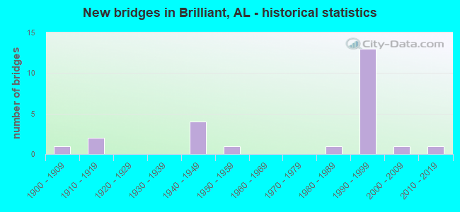
- New bridges - historical statistics
- 11900-1909
- 21910-1919
- 41940-1949
- 11950-1959
- 11980-1989
- 131990-1999
- 12000-2009
- 12010-2019

- Reconstructed bridges - Historical Statistics
- 21950-1959
- 11960-1969


- Bridge Condition - Deck
- 20.0%Very good
- 60.0%Good
- 20.0%Satisfactory

- Bridge Condition - Superstructure
- 40.0%Very good
- 50.0%Good
- 10.0%Satisfactory

- Bridge Condition - Substructure
- 50.0%Very good
- 40.0%Good
- 10.0%Satisfactory

- Bridge Condition - Channel
- 15.4%Very good
- 30.8%Good
- 38.5%Satisfactory
- 15.4%Fair

- Bridge Condition - Culverts
- 44.4%Good
- 44.4%Satisfactory
- 11.1%Fair
Find on map >> Show street view
Structure Number: 2535, Location: 1 MI W JCT AL 241 (Lat: 34.131222, Lng: -87.762639), Route carried "on" structure: US 278, Year Built: 1941, Status: Open, Structure Length: 0.67m (2.20ft), Average Daily Traffic: 1,588 (year 2020), Truck Traffic: 13%, Average Future Daily Traffic: 1,972 (year 2041), Design Load: H 15, Features Intersected: Branch, Facility Carried by Structure: AL-74
Minimum Vertical Clearance: 30+ m (98+ ft), Kilometerpoint: 29.354, Lanes on structure: 2, Base Highway Network: Yes, Owner: State Highway Agency, Approaching Roadway Width: 8.4m (27.6ft), Material/Design: Concrete, Design/Construction: Culvert, Number Of Spans In Main Unit: 2, Length of Maximum Span: 3.0m (9.8ft)
Condition: Channel: Satisfactory, Culverts: Good, Operating Rating: 88.9 metric tons, Method Used To Determine Operating Rating: Load Factor (LF), Inventory Rating: 88.9 metric tons, Method Used To Determine Inventory Rating: Load Factor (LF), Structural Evaluation: Better than present minimum criteria, Waterway Adequacy: Better than present minimum criteria, Approach Roadway Alignment: Equal to present minimum criteria, Length Of Structure Improvement: 1.30m (4.27ft), Designated Inspection Frequency: Every 24 months, Inspection Date: January 2022, Bridge Improvement Cost: $450,000, Roadway Improvement Cost: $45,000, Total Project Cost: $495,000 ( Estimate for 2022)
Find on map >> Show street view
Structure Number: 3131, Location: 0.6 MI N JCT US 278 (Lat: 34.132250, Lng: -87.732472), Route carried "on" structure: State highway 129, Year Built: 1947, Status: Open, Structure Length: 0.67m (2.20ft), Average Daily Traffic: 1,634 (year 2020), Truck Traffic: 15%, Average Future Daily Traffic: 2,223 (year 2040), Design Load: H 15, Features Intersected: Branch
Minimum Vertical Clearance: 30+ m (98+ ft), Kilometerpoint: 51.755, Lanes on structure: 2, Owner: State Highway Agency, Approaching Roadway Width: 7.6m (24.9ft), Material/Design: Concrete, Design/Construction: Culvert, Number Of Spans In Main Unit: 2, Length of Maximum Span: 3.0m (9.8ft)
Condition: Channel: Satisfactory, Culverts: Good, Operating Rating: 51.7 metric tons, Method Used To Determine Operating Rating: Load Factor (LF), Inventory Rating: 30.8 metric tons, Method Used To Determine Inventory Rating: Load Factor (LF), Structural Evaluation: Better than present minimum criteria, Waterway Adequacy: Equal to present minimum criteria, Approach Roadway Alignment: Equal to present desirable criteria, Length Of Structure Improvement: 1.30m (4.27ft), Designated Inspection Frequency: Every 24 months, Inspection Date: May 2021, Bridge Improvement Cost: $248,000, Roadway Improvement Cost: $25,000, Total Project Cost: $273,000 ( Estimate for 2022)
Find on map >> Show street view
Structure Number: 3339, Location: 1.5 MI N JCT SR 44 (Lat: 34.030917, Lng: -87.751806), Route carried "on" structure: State highway 129, Year Built: 1948, Status: Open, Structure Length: 6.22m (20.41ft), Average Daily Traffic: 2,140 (year 2020), Truck Traffic: 7%, Average Future Daily Traffic: 2,782 (year 2040), Design Load: H 15, Features Intersected: Little New River
Minimum Vertical Clearance: 30+ m (98+ ft), Kilometerpoint: 39.329, Lanes on structure: 2, Owner: State Highway Agency, Approaching Roadway Width: 7.4m (24.3ft), Material/Design: Concrete, Design/Construction: Tee Beam, Number Of Spans In Main Unit: 6, Length of Maximum Span: 10.4m (34.1ft), Curb or Sidewalk Widths: Left: 0.5m (1.6ft), Right: 0.5m (1.6ft), Curb-To-Curb Width: 7.3m (24.0ft), Out-to-Out Width: 8.9m (29.2ft)
Condition: Deck: Satisfactory, Superstructure: Good, Substructure: Good, Channel: Satisfactory, Operating Rating: 40.9 metric tons, Method Used To Determine Operating Rating: Load Factor (LF), Inventory Rating: 24.6 metric tons, Method Used To Determine Inventory Rating: Load Factor (LF), Structural Evaluation: Equal to present minimum criteria, Deck Geometry: High priority of replacement, Waterway Adequacy: Better than present minimum criteria, Approach Roadway Alignment: Better than present minimum criteria, Length Of Structure Improvement: 7.26m (23.82ft), Designated Inspection Frequency: Every 24 months, Inspection Date: May 2021, Bridge Improvement Cost: $1,444,000, Roadway Improvement Cost: $144,000, Total Project Cost: $1,588,000 ( Estimate for 2022), Deck Structure Type: Concrete Cast-file-Place
Find on map >> Show street view
Structure Number: 334, Location: 0.6 MI S JCT US 278 (Lat: 34.112500, Lng: -87.731472), Route carried "on" structure: Spur State highway 129, Year Built: 1948, Status: Open, Structure Length: 5.55m (18.21ft), Average Daily Traffic: 1,343 (year 2020), Truck Traffic: 7%, Average Future Daily Traffic: 1,757 (year 2040), Design Load: H 15, Features Intersected: Buttahatchee River
Minimum Vertical Clearance: 30+ m (98+ ft), Kilometerpoint: 49.222, Lanes on structure: 2, Owner: State Highway Agency, Approaching Roadway Width: 7.4m (24.3ft), Material/Design: Concrete, Design/Construction: Tee Beam, Number Of Spans In Main Unit: 5, Length of Maximum Span: 10.4m (34.1ft), Curb or Sidewalk Widths: Left: 0.5m (1.6ft), Right: 0.5m (1.6ft), Curb-To-Curb Width: 7.3m (24.0ft), Out-to-Out Width: 8.9m (29.2ft)
Condition: Deck: Satisfactory, Superstructure: Satisfactory, Substructure: Satisfactory, Channel: Satisfactory, Operating Rating: 38.9 metric tons, Method Used To Determine Operating Rating: Load Factor (LF), Inventory Rating: 23.3 metric tons, Method Used To Determine Inventory Rating: Load Factor (LF), Structural Evaluation: Equal to present minimum criteria, Deck Geometry: Meets minimum limits, Waterway Adequacy: Equal to present desirable criteria, Approach Roadway Alignment: Better than present minimum criteria, Length Of Structure Improvement: 6.58m (21.59ft), Designated Inspection Frequency: Every 24 months, Inspection Date: May 2021, Bridge Improvement Cost: $1,309,000, Roadway Improvement Cost: $131,000, Total Project Cost: $1,440,000 ( Estimate for 2022), Deck Structure Type: Concrete Cast-file-Place
Find on map >> Show street view
Structure Number: 5381, Location: 3000 SE OF ST RD 129 (Lat: 34.028083, Lng: -87.739917), Route carried "on" structure: County highway 24, Year Built: 1919, Year Reconstructed: 1956, Status: Open, Structure Length: 1.01m (3.31ft), Average Daily Traffic: 285 (year 2001), Truck Traffic: 25%, Average Future Daily Traffic: 650 (year 2036), Design Load: H 15, Features Intersected: LITTLE NEW RIVER
Minimum Vertical Clearance: 30+ m (98+ ft), Kilometerpoint: 0.010, Lanes on structure: 2, Owner: County Highway Agency, Approaching Roadway Width: 7.3m (24.0ft), Material/Design: Concrete, Design/Construction: Culvert, Number Of Spans In Main Unit: 3, Length of Maximum Span: 3.0m (9.8ft), Curb-To-Curb Width: 7.9m (25.9ft), Out-to-Out Width: 8.5m (27.9ft)
Condition: Channel: Fair, Culverts: Satisfactory, Operating Rating: 48.6 metric tons, Method Used To Determine Operating Rating: Load Factor (LF), Inventory Rating: 29.1 metric tons, Method Used To Determine Inventory Rating: Load Factor (LF), Structural Evaluation: Equal to present minimum criteria, Deck Geometry: Somewhat better than minimum adequacy, Waterway Adequacy: Better than present minimum criteria, Approach Roadway Alignment: Better than present minimum criteria, Length Of Structure Improvement: 1.68m (5.51ft), Designated Inspection Frequency: Every 24 months, Inspection Date: Febuary 2022, Bridge Improvement Cost: $272,000, Roadway Improvement Cost: $27,000, Total Project Cost: $299,000 ( Estimate for 2022), Deck Structure Type: Concrete Cast-file-Place, Wearing Surface/Protective System: Wearing Surface: Bituminous
Find on map >> Show street view
Structure Number: 579, Location: 2 MI W JCT AL 233 (Lat: 34.110389, Lng: -87.714556), Route carried "on" structure: US 278, Year Built: 1957, Status: Open, Structure Length: 1.74m (5.71ft), Average Daily Traffic: 1,080 (year 2013), Truck Traffic: 19%, Average Future Daily Traffic: 1,374 (year 2041), Design Load: HS 20, Features Intersected: Buttahatchee Creek, Facility Carried by Structure: AL-74
Minimum Vertical Clearance: 30+ m (98+ ft), Kilometerpoint: 33.716, Lanes on structure: 2, Base Highway Network: Yes, Owner: State Highway Agency, Approaching Roadway Width: 9.6m (31.5ft), Skew: 3 degrees, Material/Design: Concrete, Design/Construction: Culvert, Number Of Spans In Main Unit: 3, Length of Maximum Span: 4.6m (15.1ft)
Condition: Channel: Good, Culverts: Good, Operating Rating: 88.9 metric tons, Method Used To Determine Operating Rating: Load Factor (LF), Inventory Rating: 71.4 metric tons, Method Used To Determine Inventory Rating: Load Factor (LF), Structural Evaluation: Better than present minimum criteria, Waterway Adequacy: Equal to present desirable criteria, Approach Roadway Alignment: Equal to present desirable criteria, Length Of Structure Improvement: 2.44m (8.01ft), Designated Inspection Frequency: Every 24 months, Inspection Date: January 2022, Bridge Improvement Cost: $1,565,000, Roadway Improvement Cost: $157,000, Total Project Cost: $1,722,000 ( Estimate for 2022)
Find on map >> Show street view
Structure Number: 6076, Location: 3 MILES NORTH OF WINFIELD (Lat: 33.972333, Lng: -87.803222), Route carried "on" structure: County highway 47, Year Built: 1900, Year Reconstructed: 1958, Status: Open, Structure Length: 1.31m (4.30ft), Average Daily Traffic: 390 (year 2001), Truck Traffic: 30%, Average Future Daily Traffic: 784 (year 2035), Design Load: H 15, Features Intersected: East Branch Luxapallila
Minimum Vertical Clearance: 30+ m (98+ ft), Kilometerpoint: 0.010, Lanes on structure: 2, Owner: County Highway Agency, Approaching Roadway Width: 7.3m (24.0ft), Material/Design: Concrete, Design/Construction: Culvert, Number Of Spans In Main Unit: 4, Length of Maximum Span: 3.0m (9.8ft)
Condition: Channel: Satisfactory, Culverts: Fair, Operating Rating: 46.9 metric tons, Method Used To Determine Operating Rating: Load Factor (LF), Inventory Rating: 28.1 metric tons, Method Used To Determine Inventory Rating: Load Factor (LF), Structural Evaluation: Somewhat better than minimum adequacy, Waterway Adequacy: Better than present minimum criteria, Approach Roadway Alignment: Better than present minimum criteria, Length Of Structure Improvement: 1.98m (6.50ft), Designated Inspection Frequency: Every 24 months, Inspection Date: Febuary 2021, Bridge Improvement Cost: $332,000, Roadway Improvement Cost: $33,000, Total Project Cost: $365,000 ( Estimate for 2022)
Find on map >> Show street view
Structure Number: 8941, Location: 4 MILES NE WINFIELD (Lat: 33.986556, Lng: -87.810833), Route carried "on" structure: County highway 68, Year Built: 1919, Year Reconstructed: 1966, Status: Open, Structure Length: 0.67m (2.20ft), Average Daily Traffic: 240 (year 2001), Truck Traffic: 15%, Average Future Daily Traffic: 490 (year 2035), Design Load: H 20, Features Intersected: Dickenson Creek
Minimum Vertical Clearance: 30+ m (98+ ft), Kilometerpoint: 0.010, Lanes on structure: 2, Owner: County Highway Agency, Approaching Roadway Width: 7.9m (25.9ft), Material/Design: Concrete, Design/Construction: Culvert, Number Of Spans In Main Unit: 2, Length of Maximum Span: 3.0m (9.8ft)
Condition: Channel: Good, Culverts: Satisfactory, Operating Rating: 45.3 metric tons, Method Used To Determine Operating Rating: Load Factor (LF), Inventory Rating: 27.1 metric tons, Method Used To Determine Inventory Rating: Load Factor (LF), Structural Evaluation: Equal to present minimum criteria, Waterway Adequacy: Better than present minimum criteria, Approach Roadway Alignment: Better than present minimum criteria, Length Of Structure Improvement: 1.30m (4.27ft), Designated Inspection Frequency: Every 24 months, Inspection Date: Febuary 2021, Bridge Improvement Cost: $225,000, Roadway Improvement Cost: $23,000, Total Project Cost: $248,000 ( Estimate for 2022)
Find on map >> Show street view
Structure Number: 14782, Location: 1.6 MI N OF COTTONDALE (Lat: 33.172381, Lng: -87.447553), Route carried "on" structure: County highway 85, Year Built: 1989, Status: Open, Structure Length: 10.36m (33.99ft), Average Daily Traffic: 5,000 (year 2009), Truck Traffic: 50%, Average Future Daily Traffic: 4,480 (year 2029), Design Load: HS 20, Features Intersected: I-59, I-20
Minimum Vertical Clearance: 30+ m (98+ ft), Kilometerpoint: 0.000, Lanes on structure: 3, Lanes under structure: 4, Owner: State Highway Agency, Approaching Roadway Width: 16.8m (55.1ft), Material/Design: Prestressed concrete continuous, Design/Construction: Stringer/Multi-beam, Number Of Spans In Main Unit: 4, Length of Maximum Span: 26.2m (86.0ft), Curb-To-Curb Width: 16.6m (54.5ft), Out-to-Out Width: 17.3m (56.8ft)
Condition: Deck: Good, Superstructure: Very good, Substructure: Very good, Operating Rating: 42.1 metric tons, Method Used To Determine Operating Rating: Load Factor (LF), Inventory Rating: 25.2 metric tons, Method Used To Determine Inventory Rating: Load Factor (LF), Structural Evaluation: Equal to present minimum criteria, Deck Geometry: Equal to present desirable criteria, Underclear: Better than present minimum criteria, Approach Roadway Alignment: Equal to present desirable criteria, Length Of Structure Improvement: 11.28m (37.01ft), Designated Inspection Frequency: Every 24 months, Inspection Date: August 2021, Bridge Improvement Cost: $4,331,000, Roadway Improvement Cost: $433,000, Total Project Cost: $4,764,000 ( Estimate for 2022), Deck Structure Type: Concrete Cast-file-Place
Find on map >> Show street view
Structure Number: 16067, Location: 0.1 MI E JCT SR 4 (Lat: 34.012967, Lng: -87.832561), Route carried "on" structure: State highway 44, Year Built: 1994, Status: Open, Structure Length: 0.67m (2.20ft), Average Daily Traffic: 1,440 (year 2017), Truck Traffic: 12%, Average Future Daily Traffic: 1,974 (year 2041), Design Load: H 15, Features Intersected: Branch
Minimum Vertical Clearance: 30+ m (98+ ft), Kilometerpoint: 9.716, Lanes on structure: 2, Owner: State Highway Agency, Approaching Roadway Width: 15.3m (50.2ft), Material/Design: Concrete, Design/Construction: Culvert, Number Of Spans In Main Unit: 2, Length of Maximum Span: 3.0m (9.8ft)
Condition: Channel: Good, Culverts: Satisfactory, Operating Rating: 88.9 metric tons, Method Used To Determine Operating Rating: Load Factor (LF), Inventory Rating: 88.9 metric tons, Method Used To Determine Inventory Rating: Load Factor (LF), Structural Evaluation: Equal to present minimum criteria, Waterway Adequacy: Better than present minimum criteria, Approach Roadway Alignment: Equal to present desirable criteria, Length Of Structure Improvement: 1.30m (4.27ft), Designated Inspection Frequency: Every 24 months, Inspection Date: January 2021, Bridge Improvement Cost: $2,297,000, Roadway Improvement Cost: $230,000, Total Project Cost: $2,527,000 ( Estimate for 2022)
Find on map >> Show street view
Structure Number: 17205, Location: 2.8 KM W OF AL-29 JCT. (Lat: 33.998028, Lng: -87.805722), Route carried "on" structure: County highway 4, Year Built: 1997, Status: Open, Structure Length: 10.06m (33.01ft), Average Daily Traffic: 70 (year 2018), Average Future Daily Traffic: 260 (year 2041), Design Load: HS 20, Features Intersected: I-22, Facility Carried by Structure: CR-68
Minimum Vertical Clearance: 30+ m (98+ ft), Kilometerpoint: 0.068, Lanes on structure: 2, Lanes under structure: 4, Owner: State Highway Agency, Approaching Roadway Width: 6.2m (20.3ft), Material/Design: Prestressed concrete, Design/Construction: Stringer/Multi-beam, Number Of Spans In Main Unit: 4, Length of Maximum Span: 28.9m (94.8ft), Curb-To-Curb Width: 12.2m (40.0ft), Out-to-Out Width: 12.6m (41.3ft)
Condition: Deck: Good, Superstructure: Good, Substructure: Very good, Operating Rating: 60.7 metric tons, Method Used To Determine Operating Rating: Load Factor (LF), Inventory Rating: 37.1 metric tons, Method Used To Determine Inventory Rating: Load Factor (LF), Structural Evaluation: Better than present minimum criteria, Deck Geometry: Superior to present desirable criteria, Underclear: Superior to present desirable criteria, Approach Roadway Alignment: Equal to present desirable criteria, Length Of Structure Improvement: 10.99m (36.06ft), Designated Inspection Frequency: Every 24 months, Inspection Date: July 2021, Bridge Improvement Cost: $3,089,000, Roadway Improvement Cost: $309,000, Total Project Cost: $3,398,000 ( Estimate for 2022), Deck Structure Type: Concrete Cast-file-Place
Find on map >> Show street view
Structure Number: 18069, Location: AL-74 b/t AL-241*129 (Lat: 34.127167, Lng: -87.737833), Route carried "on" structure: US 278, Year Built: 2010, Status: Open, Structure Length: 6.40m (21.00ft), Average Daily Traffic: 1,057 (year 2020), Truck Traffic: 17%, Average Future Daily Traffic: 1,500 (year 2040), Design Load: HS 20, Features Intersected: Buttahatchee River, Facility Carried by Structure: AL-74
Minimum Vertical Clearance: 7.56m (24.80ft), Kilometerpoint: 31.720, Lanes on structure: 2, Base Highway Network: Yes, Owner: State Highway Agency, Approaching Roadway Width: 13.8m (45.3ft), Material/Design: Prestressed concrete, Design/Construction: Stringer/Multi-beam, Number Of Spans In Main Unit: 3, Length of Maximum Span: 21.3m (69.9ft), Curb-To-Curb Width: 13.4m (44.0ft), Out-to-Out Width: 14.3m (46.9ft)
Condition: Deck: Very good, Superstructure: Very good, Substructure: Very good, Channel: Very good, Operating Rating: 72.5 metric tons, Method Used To Determine Operating Rating: Load Factor (LF), Inventory Rating: 45.4 metric tons, Method Used To Determine Inventory Rating: Load Factor (LF), Structural Evaluation: Equal to present desirable criteria, Deck Geometry: Equal to present desirable criteria, Waterway Adequacy: Equal to present desirable criteria, Approach Roadway Alignment: Equal to present desirable criteria, Length Of Structure Improvement: 7.44m (24.41ft), Designated Inspection Frequency: Every 24 months, Inspection Date: January 2022, Bridge Improvement Cost: $2,347,000, Roadway Improvement Cost: $235,000, Total Project Cost: $2,582,000 ( Estimate for 2022), Deck Structure Type: Concrete Cast-file-Place
Find on map >> Show street view
Structure Number: 18191, Location: 0.2 MI. N. US-278 (Lat: 34.128250, Lng: -87.737944), Route carried "on" structure: Ramp State highway 129, Year Built: 2008, Status: Open, Structure Length: 6.40m (21.00ft), Average Daily Traffic: 1,634 (year 2020), Truck Traffic: 15%, Average Future Daily Traffic: 4,000 (year 2041), Design Load: HS 20, Features Intersected: Buttahatchee River
Minimum Vertical Clearance: 30+ m (98+ ft), Kilometerpoint: 50.580, Lanes on structure: 2, Owner: State Highway Agency, Approaching Roadway Width: 13.7m (44.9ft), Skew: 1 degrees, Material/Design: Prestressed concrete, Design/Construction: Stringer/Multi-beam, Number Of Spans In Main Unit: 3, Length of Maximum Span: 21.3m (69.9ft), Curb-To-Curb Width: 13.5m (44.3ft), Out-to-Out Width: 14.4m (47.2ft)
Condition: Deck: Very good, Superstructure: Very good, Substructure: Very good, Channel: Very good, Operating Rating: 81.8 metric tons, Method Used To Determine Operating Rating: Load Factor (LF), Inventory Rating: 51.8 metric tons, Method Used To Determine Inventory Rating: Load Factor (LF), Structural Evaluation: Equal to present desirable criteria, Deck Geometry: Superior to present desirable criteria, Waterway Adequacy: Equal to present desirable criteria, Approach Roadway Alignment: Equal to present desirable criteria, Length Of Structure Improvement: 7.44m (24.41ft), Designated Inspection Frequency: Every 24 months, Inspection Date: May 2021, Bridge Improvement Cost: $2,398,000, Roadway Improvement Cost: $240,000, Total Project Cost: $2,638,000 ( Estimate for 2022), Deck Structure Type: Concrete Cast-file-Place
Find on map >> Show street view
Structure Number: 18412, Location: 10.6 MI E of US-43 (Lat: 34.002639, Lng: -87.815778), Route carried "on" structure: Interstate 22, Year Built: 1997, Status: Open, Structure Length: 9.14m (29.99ft), Average Daily Traffic: 12,325 (year 2020), Truck Traffic: 32%, Average Future Daily Traffic: 15,000 (year 2040), Design Load: HS 20, Features Intersected: CR-61
Minimum Vertical Clearance: 30+ m (98+ ft), Kilometerpoint: 44.337, Lanes on structure: 2, Lanes under structure: 2, Base Highway Network: Yes, Owner: State Highway Agency, Approaching Roadway Width: 11.8m (38.7ft), Material/Design: Prestressed concrete, Design/Construction: Stringer/Multi-beam, Number Of Spans In Main Unit: 3, Length of Maximum Span: 30.5m (100.1ft), Curb-To-Curb Width: 12.2m (40.0ft), Out-to-Out Width: 13.0m (42.7ft)
Condition: Deck: Good, Superstructure: Good, Substructure: Very good, Operating Rating: 64.6 metric tons, Method Used To Determine Operating Rating: Load Factor (LF), Inventory Rating: 43.1 metric tons, Method Used To Determine Inventory Rating: Load Factor (LF), Structural Evaluation: Better than present minimum criteria, Deck Geometry: Better than present minimum criteria, Approach Roadway Alignment: Equal to present desirable criteria, Length Of Structure Improvement: 10.11m (33.17ft), Designated Inspection Frequency: Every 24 months, Inspection Date: August 2020, Bridge Improvement Cost: $2,911,000, Roadway Improvement Cost: $291,000, Total Project Cost: $3,202,000 ( Estimate for 2022), Deck Structure Type: Concrete Cast-file-Place
Find on map >> Show street view
Structure Number: 18414, Location: 10.6 MI East of US-43 (Lat: 34.002222, Lng: -87.815806), Route carried "on" structure: Interstate 22, Year Built: 1997, Status: Open, Structure Length: 9.14m (29.99ft), Average Daily Traffic: 12,325 (year 2020), Truck Traffic: 32%, Average Future Daily Traffic: 15,000 (year 2040), Design Load: HS 20, Features Intersected: CR-61
Minimum Vertical Clearance: 30+ m (98+ ft), Kilometerpoint: 44.337, Lanes on structure: 2, Lanes under structure: 2, Base Highway Network: Yes, Owner: State Highway Agency, Approaching Roadway Width: 11.8m (38.7ft), Material/Design: Prestressed concrete, Design/Construction: Stringer/Multi-beam, Number Of Spans In Main Unit: 3, Length of Maximum Span: 30.5m (100.1ft), Curb-To-Curb Width: 12.2m (40.0ft), Out-to-Out Width: 13.0m (42.7ft)
Condition: Deck: Good, Superstructure: Good, Substructure: Good, Operating Rating: 64.6 metric tons, Method Used To Determine Operating Rating: Load Factor (LF), Inventory Rating: 43.1 metric tons, Method Used To Determine Inventory Rating: Load Factor (LF), Structural Evaluation: Better than present minimum criteria, Deck Geometry: Better than present minimum criteria, Approach Roadway Alignment: Equal to present desirable criteria, Length Of Structure Improvement: 10.11m (33.17ft), Designated Inspection Frequency: Every 24 months, Inspection Date: August 2020, Bridge Improvement Cost: $2,911,000, Roadway Improvement Cost: $291,000, Total Project Cost: $3,202,000 ( Estimate for 2022), Deck Structure Type: Concrete Cast-file-Place
Find on map >> Show street view
Structure Number: 18416, Location: 11 MI E of US-43 (Lat: 33.997389, Lng: -87.802667), Route carried "on" structure: Interstate 22, Year Built: 1997, Status: Open, Structure Length: 0.86m (2.82ft), Average Daily Traffic: 12,834 (year 2020), Truck Traffic: 30%, Average Future Daily Traffic: 14,863 (year 2040), Design Load: HS 20, Features Intersected: Branch
Minimum Vertical Clearance: 30+ m (98+ ft), Kilometerpoint: 45.593, Lanes on structure: 4, Base Highway Network: Yes, Owner: State Highway Agency, Approaching Roadway Width: 22.0m (72.2ft), Skew: 21 degrees, Material/Design: Concrete, Design/Construction: Culvert, Number Of Spans In Main Unit: 3, Length of Maximum Span: 2.4m (7.9ft)
Condition: Channel: Fair, Culverts: Satisfactory, Operating Rating: 88.9 metric tons, Method Used To Determine Operating Rating: Load Factor (LF), Inventory Rating: 88.9 metric tons, Method Used To Determine Inventory Rating: Load Factor (LF), Structural Evaluation: Equal to present minimum criteria, Waterway Adequacy: Better than present minimum criteria, Approach Roadway Alignment: Equal to present desirable criteria, Length Of Structure Improvement: 1.52m (4.99ft), Designated Inspection Frequency: Every 24 months, Inspection Date: May 2020, Bridge Improvement Cost: $4,364,000, Roadway Improvement Cost: $436,000, Total Project Cost: $4,800,000 ( Estimate for 2022)
Find on map >> Show street view
Structure Number: 18417, Location: 12MI E of US-43 (Lat: 33.992611, Lng: -87.787167), Route carried "on" structure: Interstate 22, Year Built: 1997, Status: Open, Structure Length: 5.97m (19.59ft), Average Daily Traffic: 12,834 (year 2020), Truck Traffic: 30%, Average Future Daily Traffic: 15,000 (year 2040), Design Load: HS 20, Features Intersected: CR-47
Minimum Vertical Clearance: 30+ m (98+ ft), Kilometerpoint: 47.220, Lanes on structure: 2, Lanes under structure: 2, Base Highway Network: Yes, Owner: State Highway Agency, Approaching Roadway Width: 11.7m (38.4ft), Material/Design: Prestressed concrete, Design/Construction: Stringer/Multi-beam, Number Of Spans In Main Unit: 3, Length of Maximum Span: 24.4m (80.1ft), Curb-To-Curb Width: 11.9m (39.0ft), Out-to-Out Width: 12.9m (42.3ft)
Condition: Deck: Good, Superstructure: Very good, Substructure: Good, Operating Rating: 59.8 metric tons, Method Used To Determine Operating Rating: Load Factor (LF), Inventory Rating: 38.9 metric tons, Method Used To Determine Inventory Rating: Load Factor (LF), Structural Evaluation: Better than present minimum criteria, Deck Geometry: Somewhat better than minimum adequacy, Underclear: Superior to present desirable criteria, Approach Roadway Alignment: Equal to present desirable criteria, Length Of Structure Improvement: 7.01m (23.00ft), Designated Inspection Frequency: Every 24 months, Inspection Date: August 2020, Bridge Improvement Cost: $2,020,000, Roadway Improvement Cost: $202,000, Total Project Cost: $2,222,000 ( Estimate for 2022), Deck Structure Type: Concrete Cast-file-Place
Find on map >> Show street view
Structure Number: 1842, Location: on CR-47 (Lat: 33.992944, Lng: -87.787028), Route carried "on" structure: Interstate 22, Year Built: 1993, Status: Open, Structure Length: 0.87m (2.85ft), Average Daily Traffic: 12,834 (year 2020), Truck Traffic: 30%, Average Future Daily Traffic: 14,863 (year 2040), Design Load: HS 20, Features Intersected: AL-4
Minimum Vertical Clearance: 30+ m (98+ ft), Kilometerpoint: 47.220, Lanes on structure: 2, Base Highway Network: Yes, Owner: State Highway Agency, Approaching Roadway Width: 12.1m (39.7ft), Skew: 4 degrees, Material/Design: Concrete, Design/Construction: Culvert, Number Of Spans In Main Unit: 3, Length of Maximum Span: 1.8m (5.9ft)
Condition: Channel: Good, Culverts: Good, Operating Rating: 88.9 metric tons, Method Used To Determine Operating Rating: Load Factor (LF), Inventory Rating: 74.6 metric tons, Method Used To Determine Inventory Rating: Load Factor (LF), Structural Evaluation: Better than present minimum criteria, Waterway Adequacy: Better than present minimum criteria, Approach Roadway Alignment: Equal to present desirable criteria, Length Of Structure Improvement: 1.53m (5.02ft), Designated Inspection Frequency: Every 24 months, Inspection Date: May 2020, Bridge Improvement Cost: $779,000, Roadway Improvement Cost: $78,000, Total Project Cost: $857,000 ( Estimate for 2022)
Find on map >> Show street view
Structure Number: 18449, Location: 12 MI E of US-43 (Lat: 33.992000, Lng: -87.787194), Route carried "on" structure: Interstate 22, Year Built: 1997, Status: Open, Structure Length: 5.97m (19.59ft), Average Daily Traffic: 12,834 (year 2020), Truck Traffic: 30%, Average Future Daily Traffic: 15,000 (year 2040), Design Load: HS 20, Features Intersected: CR-47
Minimum Vertical Clearance: 30+ m (98+ ft), Kilometerpoint: 47.220, Lanes on structure: 2, Lanes under structure: 2, Base Highway Network: Yes, Owner: State Highway Agency, Approaching Roadway Width: 11.7m (38.4ft), Material/Design: Prestressed concrete, Design/Construction: Stringer/Multi-beam, Number Of Spans In Main Unit: 3, Length of Maximum Span: 24.4m (80.1ft), Curb-To-Curb Width: 11.9m (39.0ft), Out-to-Out Width: 13.0m (42.7ft)
Condition: Deck: Good, Superstructure: Good, Substructure: Good, Operating Rating: 59.8 metric tons, Method Used To Determine Operating Rating: Load Factor (LF), Inventory Rating: 38.9 metric tons, Method Used To Determine Inventory Rating: Load Factor (LF), Structural Evaluation: Better than present minimum criteria, Deck Geometry: Equal to present minimum criteria, Underclear: Superior to present desirable criteria, Approach Roadway Alignment: Equal to present desirable criteria, Length Of Structure Improvement: 7.01m (23.00ft), Designated Inspection Frequency: Every 24 months, Inspection Date: August 2020, Bridge Improvement Cost: $2,020,000, Roadway Improvement Cost: $202,000, Total Project Cost: $2,222,000 ( Estimate for 2022), Deck Structure Type: Concrete Cast-file-Place
Find on map >> Show street view
Structure Number: 17205, Location: 2.8 KM W OF AL-29 JCT. (Lat: 33.998028, Lng: -87.805722), Route carried "under" structure: Interstate 22, Year Built: 1997, Structure Length: 0. m, Average Daily Traffic: 10,970 (year 2018), Truck Traffic: 32%, Features Intersected: I-22, Facility Carried by Structure: CR-68
Minimum Vertical Clearance: 5.88m (19.29ft), Kilometerpoint: 45.316, Lanes on structure: 2, Lanes under structure: 4, Material/Design: Prestressed concrete, Design/Construction: Stringer/Multi-beam, Length of Maximum Span: 28.9m (94.8ft)
Find on map >> Show street view
Structure Number: 18412, Location: 10.6 MI E of US-43 (Lat: 34.002639, Lng: -87.815778), Route carried "under" structure: County highway 61, Year Built: 1997, Structure Length: 0. m, Average Daily Traffic: 75 (year 2018), Features Intersected: CR-61, Facility Carried by Structure: I-22
Minimum Vertical Clearance: 9.45m (31.00ft), Kilometerpoint: 5.795, Lanes on structure: 2, Lanes under structure: 2, Material/Design: Prestressed concrete, Design/Construction: Stringer/Multi-beam, Length of Maximum Span: 30.5m (100.1ft)
Find on map >> Show street view
Structure Number: 18414, Location: 10.6 MI East of US-43 (Lat: 34.002222, Lng: -87.815806), Route carried "under" structure: County highway 61, Year Built: 1997, Structure Length: 0. m, Average Daily Traffic: 75 (year 2018), Features Intersected: CR-61, Facility Carried by Structure: I-22
Minimum Vertical Clearance: 9.45m (31.00ft), Kilometerpoint: 5.794, Lanes on structure: 2, Lanes under structure: 2, Material/Design: Prestressed concrete, Design/Construction: Stringer/Multi-beam, Length of Maximum Span: 30.5m (100.1ft)
Find on map >> Show street view
Structure Number: 18417, Location: 12MI E of US-43 (Lat: 33.992611, Lng: -87.787167), Route carried "under" structure: County highway 47, Year Built: 1997, Structure Length: 0. m, Average Daily Traffic: 50 (year 2018), Features Intersected: CR-47, Facility Carried by Structure: I-22
Minimum Vertical Clearance: 5.94m (19.49ft), Kilometerpoint: 7.966, Lanes on structure: 2, Lanes under structure: 2, Material/Design: Prestressed concrete, Design/Construction: Stringer/Multi-beam, Length of Maximum Span: 24.4m (80.1ft)
Find on map >> Show street view
Structure Number: 18449, Location: 12 MI E of US-43 (Lat: 33.992000, Lng: -87.787194), Route carried "under" structure: County highway 47, Year Built: 1997, Structure Length: 0. m, Average Daily Traffic: 200 (year 2018), Truck Traffic: 1%, Features Intersected: CR-47, Facility Carried by Structure: I-22
Minimum Vertical Clearance: 5.79m (19.00ft), Kilometerpoint: 7.968, Lanes on structure: 2, Lanes under structure: 2, Material/Design: Prestressed concrete, Design/Construction: Stringer/Multi-beam, Length of Maximum Span: 24.4m (80.1ft)