Bridge Statistics for Bristol, Indiana (IN)
Condition, Traffic, Stress, Structural Evaluation, Project Costs
- National Bridge Inventory (NBI) Statistics
- 46Number of bridges
- 400ft / 122mTotal length
- $132,000Total costs
- 393,985Total average daily traffic
- 132,015Total average daily truck traffic
- National Bridge Inventory (NBI) Registered Bridges for Bristol
- No street view available for this location
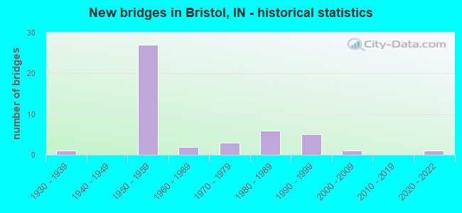
- New bridges - historical statistics
- 11930-1939
- 271950-1959
- 21960-1969
- 31970-1979
- 61980-1989
- 51990-1999
- 12000-2009
- 12020-2022

- Reconstructed bridges - Historical Statistics
- 11970-1979
- 01980-1989
- 41990-1999
- 82000-2009


- Bridge Condition - Deck
- 12.5%Excellent
- 8.3%Very good
- 70.8%Good
- 4.2%Satisfactory
- 4.2%Fair

- Bridge Condition - Superstructure
- 4.2%Excellent
- 4.2%Very good
- 79.2%Good
- 8.3%Satisfactory
- 4.2%Fair

- Bridge Condition - Substructure
- 4.2%Excellent
- 4.2%Very good
- 70.8%Good
- 20.8%Satisfactory

- Bridge Condition - Channel
- 7.1%Excellent
- 21.4%Very good
- 35.7%Good
- 35.7%Satisfactory

- Bridge Condition - Culverts
- 50.0%Good
- 50.0%Satisfactory
Find on map >> Show street view
Structure Number: 418, Location: 01.10 N SR 120 (Lat: 41.734661, Lng: -85.800186), Route carried "on" structure: State highway 15, Year Built: 1956, Year Reconstructed: 2003, Status: Open, Structure Length: 8.47m (27.79ft), Average Daily Traffic: 6,977 (year 2015), Truck Traffic: 26%, Average Future Daily Traffic: 14,819 (year 2031), Design Load: HS 20, Features Intersected: I-90 EB/WB
Minimum Vertical Clearance: 30+ m (98+ ft), Kilometerpoint: 34.842, Lanes on structure: 2, Lanes under structure: 4, Base Highway Network: Yes (, Subroute: 1), Owner: State Toll Authority, Approaching Roadway Width: 12.8m (42.0ft), Skew: 4 degrees, Material/Design: Steel continuous, Design/Construction: Girder and Floorbeam System, Number Of Spans In Main Unit: 4, Length of Maximum Span: 26.6m (87.3ft), Curb or Sidewalk Widths: Left: 0.6m (2.0ft), Right: 0.6m (2.0ft), Curb-To-Curb Width: 9.1m (29.9ft), Out-to-Out Width: 11.0m (36.1ft)
Condition: Deck: Good, Superstructure: Satisfactory, Substructure: Good, Operating Rating: 53.1 metric tons, Method Used To Determine Operating Rating: Load and Resistance Factor Rating (LRFR) rating reported by rating factor(RF) method using HL-93 loadings, Inventory Rating: 40.8 metric tons, Method Used To Determine Inventory Rating: Load and Resistance Factor Rating (LRFR) rating reported by rating factor(RF) method using HL-93 loadings, Structural Evaluation: Equal to present minimum criteria, Deck Geometry: Meets minimum limits, Underclear: Somewhat better than minimum adequacy, Approach Roadway Alignment: Equal to present minimum criteria, Designated Inspection Frequency: Every 24 months, Other Special Inspection Frequency: Every 24 months, Inspection Date: August 2021, Other Special Inspection Date: August 2021, Deck Structure Type: Concrete Cast-file-Place, Wearing Surface/Protective System: Wearing Surface: Latex Concrete
Find on map >> Show street view
Structure Number: 4811, Location: 03.60 E SR 13 (Lat: 40.569031, Lng: -85.756869), Route carried "on" structure: State highway 18, Year Built: 2021, Status: Open, Structure Length: 3.86m (12.66ft), Average Daily Traffic: 7,180 (year 2020), Truck Traffic: 9%, Average Future Daily Traffic: 8,760 (year 2040), Design Load: HL 93, Features Intersected: PIPE CREEK
Minimum Vertical Clearance: 30+ m (98+ ft), Kilometerpoint: 9.737, Lanes on structure: 2, Owner: State Highway Agency, Approaching Roadway Width: 13.4m (44.0ft), Skew: 3 degrees, Material/Design: Concrete continuous, Design/Construction: Slab, Number Of Spans In Main Unit: 3, Length of Maximum Span: 15.2m (49.9ft), Curb-To-Curb Width: 13.4m (44.0ft), Out-to-Out Width: 14.3m (46.9ft)
Condition: Deck: Excellent, Superstructure: Excellent, Substructure: Excellent, Channel: Excellent, Operating Rating: 63.2 metric tons, Method Used To Determine Operating Rating: Load and Resistance Factor Rating (LRFR) rating reported by rating factor(RF) method using HL-93 loadings, Inventory Rating: 48.9 metric tons, Method Used To Determine Inventory Rating: Load and Resistance Factor Rating (LRFR) rating reported by rating factor(RF) method using HL-93 loadings, Structural Evaluation: Superior to present desirable criteria, Deck Geometry: Equal to present minimum criteria, Waterway Adequacy: Superior to present desirable criteria, Approach Roadway Alignment: Equal to present desirable criteria, Designated Inspection Frequency: Every 24 months, Inspection Date: November 2021, Deck Structure Type: Concrete Cast-file-Place, Wearing Surface/Protective System: Wearing Surface: Monolithic Concrete, Deck Protection: Epoxy Coated Reinforcing
Find on map >> Show street view
Structure Number: 2589, Location: 01.04 E SR 15 (Lat: 41.725000, Lng: -85.793781), Route carried "on" structure: State highway 120, Year Built: 2003, Status: Open, Structure Length: 3.35m (10.99ft), Average Daily Traffic: 6,860 (year 2021), Truck Traffic: 24%, Average Future Daily Traffic: 7,470 (year 2041), Design Load: HS 20+Mod, Features Intersected: LITTLE ELKHART RIVER
Minimum Vertical Clearance: 30+ m (98+ ft), Kilometerpoint: 10.960, Lanes on structure: 2, Owner: State Highway Agency, Approaching Roadway Width: 13.4m (44.0ft), Skew: 2 degrees, Material/Design: Concrete continuous, Design/Construction: Slab, Number Of Spans In Main Unit: 3, Length of Maximum Span: 13.2m (43.3ft), Curb-To-Curb Width: 13.4m (44.0ft), Out-to-Out Width: 14.3m (46.9ft)
Condition: Deck: Good, Superstructure: Good, Substructure: Very good, Channel: Very good, Operating Rating: 60.9 metric tons, Method Used To Determine Operating Rating: Load Factor (LF), Inventory Rating: 36.5 metric tons, Method Used To Determine Inventory Rating: Load Factor (LF), Structural Evaluation: Better than present minimum criteria, Deck Geometry: Equal to present minimum criteria, Waterway Adequacy: Equal to present desirable criteria, Approach Roadway Alignment: Equal to present desirable criteria, Designated Inspection Frequency: Every 24 months, Inspection Date: April 2020, Deck Structure Type: Concrete Cast-file-Place, Wearing Surface/Protective System: Wearing Surface: Epoxy Overlay, Deck Protection: Epoxy Coated Reinforcing
Find on map >> Show street view
Structure Number: 48073, Location: 04.39 E SR 19 (Lat: 41.730281, Lng: -85.888475), Route carried "on" structure: County highway , Year Built: 1996, Status: Open, Structure Length: 8.60m (28.22ft), Average Daily Traffic: 10,518 (year 2014), Truck Traffic: 18%, Average Future Daily Traffic: 11,082 (year 2031), Design Load: HS 20, Features Intersected: I-90 EB/WB, Facility Carried by Structure: CR 17
Minimum Vertical Clearance: 30+ m (98+ ft), Kilometerpoint: 154.497, Lanes on structure: 4, Lanes under structure: 4, Owner: State Toll Authority, Approaching Roadway Width: 20.7m (67.9ft), Material/Design: Steel continuous, Design/Construction: Stringer/Multi-beam, Number Of Spans In Main Unit: 2, Length of Maximum Span: 45.7m (149.9ft), Curb-To-Curb Width: 20.5m (67.3ft), Out-to-Out Width: 21.4m (70.2ft)
Condition: Deck: Good, Superstructure: Good, Substructure: Good, Operating Rating: 59.6 metric tons, Method Used To Determine Operating Rating: Load Factor (LF), Inventory Rating: 35.7 metric tons, Method Used To Determine Inventory Rating: Load Factor (LF), Structural Evaluation: Better than present minimum criteria, Deck Geometry: Superior to present desirable criteria, Underclear: Somewhat better than minimum adequacy, Approach Roadway Alignment: Equal to present desirable criteria, Designated Inspection Frequency: Every 24 months, Inspection Date: August 2021, Deck Structure Type: Concrete Cast-file-Place, Wearing Surface/Protective System: Wearing Surface: Monolithic Concrete, Deck Protection: Epoxy Coated Reinforcing
Find on map >> Show street view
Structure Number: 4808, Location: 03.72 W SR 15 (Lat: 41.730969, Lng: -85.870889), Route carried "on" structure: County highway 19, Year Built: 1956, Year Reconstructed: 2002, Status: Open, Structure Length: 6.58m (21.59ft), Average Daily Traffic: 1,031 (year 2014), Truck Traffic: 9%, Average Future Daily Traffic: 7,601 (year 2031), Design Load: HS 20, Features Intersected: I-90 EB/WB
Minimum Vertical Clearance: 30+ m (98+ ft), Kilometerpoint: 155.945, Lanes on structure: 2, Lanes under structure: 4, Owner: State Toll Authority, Approaching Roadway Width: 11.0m (36.1ft), Material/Design: Steel, Design/Construction: Stringer/Multi-beam, Number Of Spans In Main Unit: 4, Number Of Approach Spans: 2, Length of Maximum Span: 20.0m (65.6ft), Curb-To-Curb Width: 8.2m (26.9ft), Out-to-Out Width: 9.1m (29.9ft)
Condition: Deck: Good, Superstructure: Good, Substructure: Good, Operating Rating: 75.1 metric tons, Method Used To Determine Operating Rating: Load Factor (LF), Inventory Rating: 45.0 metric tons, Method Used To Determine Inventory Rating: Load Factor (LF), Structural Evaluation: Better than present minimum criteria, Deck Geometry: Meets minimum limits, Underclear: Somewhat better than minimum adequacy, Approach Roadway Alignment: Equal to present minimum criteria, Designated Inspection Frequency: Every 24 months, Other Special Inspection Frequency: Every 24 months, Inspection Date: August 2021, Other Special Inspection Date: August 2021, Deck Structure Type: Concrete Cast-file-Place, Wearing Surface/Protective System: Wearing Surface: Monolithic Concrete, Deck Protection: Epoxy Coated Reinforcing
Find on map >> Show street view
Structure Number: 48082, Location: 00.68 E CR 19 (Lat: 41.731250, Lng: -85.857681), Route carried "on" structure: Interstate 90, Year Built: 1956, Status: Open, Structure Length: 0.93m (3.05ft), Average Daily Traffic: 25,630 (year 2015), Truck Traffic: 38%, Average Future Daily Traffic: 49,182 (year 2030), Design Load: HS 20, Features Intersected: WASHINGTON TWP DRAIN
Minimum Vertical Clearance: 30+ m (98+ ft), Kilometerpoint: 157.185, Lanes on structure: 4, Base Highway Network: Yes (, Subroute: 1), Toll: On toll road, Owner: State Toll Authority, Approaching Roadway Width: 37.8m (124.0ft), Skew: 11 degrees, Material/Design: Concrete, Design/Construction: Culvert, Number Of Spans In Main Unit: 2, Length of Maximum Span: 4.3m (14.1ft)
Condition: Channel: Good, Culverts: Good, Inventory Rating: 66.0 metric tons, Method Used To Determine Inventory Rating: Load Factor (LF), Structural Evaluation: Better than present minimum criteria, Waterway Adequacy: Equal to present desirable criteria, Approach Roadway Alignment: Equal to present desirable criteria, Designated Inspection Frequency: Every 24 months, Inspection Date: July 2021
Find on map >> Show street view
Structure Number: 4809, Location: 02.21 W SR 15 (Lat: 41.732411, Lng: -85.841819), Route carried "on" structure: Interstate 90, Year Built: 1956, Year Reconstructed: 2021, Status: Open, Structure Length: 2.93m (9.61ft), Average Daily Traffic: 12,815 (year 2015), Truck Traffic: 38%, Average Future Daily Traffic: 28,508 (year 2031), Design Load: HS 20, Features Intersected: CR 21
Minimum Vertical Clearance: 30+ m (98+ ft), Kilometerpoint: 158.520, Lanes on structure: 2, Lanes under structure: 2, Base Highway Network: Yes (, Subroute: 1), Toll: On toll road, Owner: State Toll Authority, Approaching Roadway Width: 12.8m (42.0ft), Skew: 1 degrees, Material/Design: Steel, Design/Construction: Stringer/Multi-beam, Number Of Spans In Main Unit: 3, Length of Maximum Span: 8.9m (29.2ft), Curb-To-Curb Width: 11.5m (37.7ft), Out-to-Out Width: 12.4m (40.7ft)
Condition: Deck: Excellent, Superstructure: Good, Substructure: Good, Operating Rating: 63.7 metric tons, Method Used To Determine Operating Rating: Load Factor (LF), Inventory Rating: 38.2 metric tons, Method Used To Determine Inventory Rating: Load Factor (LF), Structural Evaluation: Better than present minimum criteria, Deck Geometry: Somewhat better than minimum adequacy, Underclear: Meets minimum limits, Approach Roadway Alignment: Equal to present desirable criteria, Designated Inspection Frequency: Every 24 months, Inspection Date: March 2022, Deck Structure Type: Concrete Cast-file-Place, Wearing Surface/Protective System: Wearing Surface: Latex Concrete
Find on map >> Show street view
Structure Number: 481, Location: 02.21 W SR 15 (Lat: 41.732631, Lng: -85.841836), Route carried "on" structure: Interstate 90, Year Built: 1956, Year Reconstructed: 2021, Status: Open, Structure Length: 2.93m (9.61ft), Average Daily Traffic: 12,815 (year 2015), Truck Traffic: 38%, Average Future Daily Traffic: 28,508 (year 2031), Design Load: HS 20, Features Intersected: CR 21
Minimum Vertical Clearance: 30+ m (98+ ft), Kilometerpoint: 158.520, Lanes on structure: 2, Lanes under structure: 2, Base Highway Network: Yes (, Subroute: 1), Toll: On toll road, Owner: State Toll Authority, Approaching Roadway Width: 12.8m (42.0ft), Skew: 1 degrees, Material/Design: Steel, Design/Construction: Stringer/Multi-beam, Number Of Spans In Main Unit: 3, Length of Maximum Span: 8.9m (29.2ft), Curb-To-Curb Width: 11.5m (37.7ft), Out-to-Out Width: 12.4m (40.7ft)
Condition: Deck: Excellent, Superstructure: Good, Substructure: Good, Operating Rating: 44.7 metric tons, Method Used To Determine Operating Rating: Load and Resistance Factor Rating (LRFR) rating reported by rating factor(RF) method using HL-93 loadings, Inventory Rating: 34.3 metric tons, Method Used To Determine Inventory Rating: Load and Resistance Factor Rating (LRFR) rating reported by rating factor(RF) method using HL-93 loadings, Structural Evaluation: Better than present minimum criteria, Deck Geometry: Somewhat better than minimum adequacy, Underclear: Meets minimum limits, Approach Roadway Alignment: Equal to present desirable criteria, Designated Inspection Frequency: Every 24 months, Other Special Inspection Frequency: Every 24 months, Inspection Date: August 2021, Other Special Inspection Date: August 2021, Deck Structure Type: Concrete Cast-file-Place, Wearing Surface/Protective System: Wearing Surface: Latex Concrete
Find on map >> Show street view
Structure Number: 4811, Location: 01.18 W SR 15 (Lat: 41.736611, Lng: -85.822678), Route carried "on" structure: County highway 23, Year Built: 1956, Year Reconstructed: 2002, Status: Open, Structure Length: 6.58m (21.59ft), Average Daily Traffic: 1,962 (year 2014), Truck Traffic: 16%, Average Future Daily Traffic: 6,384 (year 2031), Design Load: HS 20, Features Intersected: I-90 EB/WB
Minimum Vertical Clearance: 30+ m (98+ ft), Kilometerpoint: 0.000, Lanes on structure: 2, Lanes under structure: 4, Owner: State Toll Authority, Approaching Roadway Width: 11.0m (36.1ft), Material/Design: Steel, Design/Construction: Stringer/Multi-beam, Number Of Spans In Main Unit: 4, Number Of Approach Spans: 2, Length of Maximum Span: 20.0m (65.6ft), Curb-To-Curb Width: 8.2m (26.9ft), Out-to-Out Width: 9.1m (29.9ft)
Condition: Deck: Very good, Superstructure: Good, Substructure: Satisfactory, Operating Rating: 66.1 metric tons, Method Used To Determine Operating Rating: Load Factor (LF), Inventory Rating: 39.6 metric tons, Method Used To Determine Inventory Rating: Load Factor (LF), Structural Evaluation: Equal to present minimum criteria, Deck Geometry: Meets minimum limits, Underclear: Somewhat better than minimum adequacy, Approach Roadway Alignment: Equal to present minimum criteria, Designated Inspection Frequency: Every 24 months, Other Special Inspection Frequency: Every 24 months, Inspection Date: August 2021, Other Special Inspection Date: August 2021, Deck Structure Type: Concrete Cast-file-Place, Wearing Surface/Protective System: Wearing Surface: Monolithic Concrete, Deck Protection: Epoxy Coated Reinforcing
Find on map >> Show street view
Structure Number: 4812, Location: 00.57 W SR 15 (Lat: 41.735069, Lng: -85.811103), Route carried "on" structure: Interstate 90, Year Built: 1956, Year Reconstructed: 2007, Status: Open, Structure Length: 13.11m (43.01ft), Average Daily Traffic: 11,863 (year 2011), Truck Traffic: 24%, Average Future Daily Traffic: 24,591 (year 2030), Design Load: HS 20, Features Intersected: CR 25, ST JOE RIVER
Minimum Vertical Clearance: 30+ m (98+ ft), Kilometerpoint: 161.160, Lanes on structure: 2, Lanes under structure: 2, Base Highway Network: Yes (, Subroute: 1), Toll: On toll road, Owner: State Toll Authority, Approaching Roadway Width: 12.8m (42.0ft), Material/Design: Steel continuous, Design/Construction: Stringer/Multi-beam, Number Of Spans In Main Unit: 6, Length of Maximum Span: 21.3m (69.9ft), Curb-To-Curb Width: 12.8m (42.0ft), Out-to-Out Width: 13.7m (44.9ft)
Condition: Deck: Good, Superstructure: Good, Substructure: Good, Channel: Very good, Operating Rating: 64.1 metric tons, Method Used To Determine Operating Rating: Load Factor (LF), Inventory Rating: 38.4 metric tons, Method Used To Determine Inventory Rating: Load Factor (LF), Structural Evaluation: Better than present minimum criteria, Deck Geometry: Equal to present desirable criteria, Underclear: Meets minimum limits, Waterway Adequacy: Equal to present minimum criteria, Approach Roadway Alignment: Equal to present desirable criteria, Designated Inspection Frequency: Every 24 months, Underwater Inspection Frequency: Every 60 months, Inspection Date: August 2021, Underwater Inspection Date: June 2017, Deck Structure Type: Concrete Cast-file-Place, Wearing Surface/Protective System: Wearing Surface: Monolithic Concrete, Deck Protection: Epoxy Coated Reinforcing
Find on map >> Show street view
Structure Number: 4813, Location: 00.57 W SR 15 (Lat: 41.735289, Lng: -85.811089), Route carried "on" structure: Interstate 90, Year Built: 1956, Year Reconstructed: 2007, Status: Open, Structure Length: 13.11m (43.01ft), Average Daily Traffic: 11,864 (year 2011), Truck Traffic: 25%, Average Future Daily Traffic: 24,591 (year 2030), Design Load: HS 20, Features Intersected: CR 25, ST JOE RIVER
Minimum Vertical Clearance: 30+ m (98+ ft), Kilometerpoint: 161.160, Lanes on structure: 2, Lanes under structure: 2, Base Highway Network: Yes (, Subroute: 1), Toll: On toll road, Owner: State Toll Authority, Approaching Roadway Width: 12.8m (42.0ft), Material/Design: Steel continuous, Design/Construction: Stringer/Multi-beam, Number Of Spans In Main Unit: 6, Length of Maximum Span: 21.3m (69.9ft), Curb-To-Curb Width: 12.8m (42.0ft), Out-to-Out Width: 13.7m (44.9ft)
Condition: Deck: Good, Superstructure: Good, Substructure: Good, Channel: Very good, Operating Rating: 64.1 metric tons, Method Used To Determine Operating Rating: Load Factor (LF), Inventory Rating: 38.4 metric tons, Method Used To Determine Inventory Rating: Load Factor (LF), Structural Evaluation: Better than present minimum criteria, Deck Geometry: Equal to present desirable criteria, Underclear: Meets minimum limits, Waterway Adequacy: Equal to present minimum criteria, Approach Roadway Alignment: Equal to present desirable criteria, Designated Inspection Frequency: Every 24 months, Underwater Inspection Frequency: Every 60 months, Inspection Date: August 2021, Underwater Inspection Date: June 2017, Deck Structure Type: Concrete Cast-file-Place, Wearing Surface/Protective System: Wearing Surface: Monolithic Concrete, Deck Protection: Epoxy Coated Reinforcing
Find on map >> Show street view
Structure Number: 4814, Location: 00.51 E SR 15 (Lat: 41.735161, Lng: -85.790375), Route carried "on" structure: Ramp Interstate 90, Year Built: 1983, Status: Open, Structure Length: 7.25m (23.79ft), Average Daily Traffic: 1,130 (year 2014), Truck Traffic: 20%, Average Future Daily Traffic: 970 (year 2031), Design Load: HS 20, Features Intersected: I-90 EB/WB
Minimum Vertical Clearance: 30+ m (98+ ft), Kilometerpoint: 162.898, Lanes on structure: 2, Lanes under structure: 5, Base Highway Network: Yes (, Subroute: 1), Toll: On toll road, Owner: State Toll Authority, Approaching Roadway Width: 37.8m (124.0ft), Skew: 31 degrees, Material/Design: Steel continuous, Design/Construction: Stringer/Multi-beam, Number Of Spans In Main Unit: 2, Length of Maximum Span: 39.0m (128.0ft), Curb-To-Curb Width: 18.0m (59.1ft), Out-to-Out Width: 19.0m (62.3ft)
Condition: Deck: Good, Superstructure: Good, Substructure: Good, Operating Rating: 49.9 metric tons, Method Used To Determine Operating Rating: Load Factor (LF), Inventory Rating: 29.9 metric tons, Method Used To Determine Inventory Rating: Load Factor (LF), Structural Evaluation: Better than present minimum criteria, Deck Geometry: Superior to present desirable criteria, Underclear: Somewhat better than minimum adequacy, Approach Roadway Alignment: Equal to present desirable criteria, Designated Inspection Frequency: Every 24 months, Inspection Date: August 2021, Deck Structure Type: Concrete Cast-file-Place, Wearing Surface/Protective System: Wearing Surface: Latex Concrete
Find on map >> Show street view
Structure Number: 4815, Location: 00.86 E SR 15 (Lat: 41.734869, Lng: -85.783614), Route carried "on" structure: Interstate 90, Year Built: 1956, Year Reconstructed: 2005, Status: Open, Structure Length: 3.66m (12.01ft), Average Daily Traffic: 12,465 (year 2015), Truck Traffic: 39%, Average Future Daily Traffic: 26,884 (year 2031), Design Load: HS 20, Features Intersected: CR 29
Minimum Vertical Clearance: 30+ m (98+ ft), Kilometerpoint: 163.461, Lanes on structure: 2, Lanes under structure: 2, Base Highway Network: Yes (, Subroute: 1), Toll: On toll road, Owner: State Toll Authority, Approaching Roadway Width: 14.0m (45.9ft), Skew: 1 degrees, Material/Design: Steel continuous, Design/Construction: Stringer/Multi-beam, Number Of Spans In Main Unit: 3, Length of Maximum Span: 10.7m (35.1ft), Curb-To-Curb Width: 14.0m (45.9ft), Out-to-Out Width: 14.9m (48.9ft)
Condition: Deck: Good, Superstructure: Good, Substructure: Good, Operating Rating: 66.8 metric tons, Method Used To Determine Operating Rating: Load Factor (LF), Inventory Rating: 40.0 metric tons, Method Used To Determine Inventory Rating: Load Factor (LF), Structural Evaluation: Better than present minimum criteria, Deck Geometry: Superior to present desirable criteria, Underclear: Meets minimum limits, Approach Roadway Alignment: Equal to present desirable criteria, Designated Inspection Frequency: Every 24 months, Inspection Date: August 2021, Deck Structure Type: Concrete Cast-file-Place, Wearing Surface/Protective System: Wearing Surface: Monolithic Concrete
Find on map >> Show street view
Structure Number: 4816, Location: 00.86 E SR 15 (Lat: 41.735100, Lng: -85.783608), Route carried "on" structure: Interstate 90, Year Built: 1956, Year Reconstructed: 2005, Status: Open, Structure Length: 3.66m (12.01ft), Average Daily Traffic: 12,465 (year 2015), Truck Traffic: 39%, Average Future Daily Traffic: 26,884 (year 2031), Design Load: HS 20, Features Intersected: CR 29
Minimum Vertical Clearance: 30+ m (98+ ft), Kilometerpoint: 163.461, Lanes on structure: 2, Lanes under structure: 2, Base Highway Network: Yes (, Subroute: 1), Toll: On toll road, Owner: State Toll Authority, Approaching Roadway Width: 14.0m (45.9ft), Skew: 1 degrees, Material/Design: Steel continuous, Design/Construction: Stringer/Multi-beam, Number Of Spans In Main Unit: 3, Length of Maximum Span: 10.7m (35.1ft), Curb-To-Curb Width: 14.0m (45.9ft), Out-to-Out Width: 14.9m (48.9ft)
Condition: Deck: Good, Superstructure: Very good, Substructure: Good, Operating Rating: 67.0 metric tons, Method Used To Determine Operating Rating: Load Factor (LF), Inventory Rating: 40.1 metric tons, Method Used To Determine Inventory Rating: Load Factor (LF), Structural Evaluation: Better than present minimum criteria, Deck Geometry: Superior to present desirable criteria, Underclear: Meets minimum limits, Approach Roadway Alignment: Equal to present desirable criteria, Designated Inspection Frequency: Every 24 months, Inspection Date: August 2021, Deck Structure Type: Concrete Cast-file-Place, Wearing Surface/Protective System: Wearing Surface: Monolithic Concrete
Find on map >> Show street view
Structure Number: 4817, Location: 01.26 E SR 15 (Lat: 41.731569, Lng: -85.777589), Route carried "on" structure: Interstate 90, Year Built: 1956, Year Reconstructed: 2005, Status: Open, Structure Length: 4.85m (15.91ft), Average Daily Traffic: 12,465 (year 2015), Truck Traffic: 39%, Average Future Daily Traffic: 26,884 (year 2031), Design Load: HS 20, Features Intersected: GRAND ELK RR
Minimum Vertical Clearance: 30+ m (98+ ft), Kilometerpoint: 164.105, Lanes on structure: 2, Base Highway Network: Yes (, Subroute: 1), Toll: On toll road, Owner: State Toll Authority, Approaching Roadway Width: 14.0m (45.9ft), Skew: 2 degrees, Material/Design: Steel continuous, Design/Construction: Stringer/Multi-beam, Number Of Spans In Main Unit: 3, Length of Maximum Span: 15.5m (50.9ft), Curb-To-Curb Width: 14.0m (45.9ft), Out-to-Out Width: 14.9m (48.9ft)
Condition: Deck: Good, Superstructure: Good, Substructure: Good, Operating Rating: 78.7 metric tons, Method Used To Determine Operating Rating: Load Factor (LF), Inventory Rating: 47.1 metric tons, Method Used To Determine Inventory Rating: Load Factor (LF), Structural Evaluation: Better than present minimum criteria, Deck Geometry: Superior to present desirable criteria, Underclear: Equal to present desirable criteria, Approach Roadway Alignment: Equal to present desirable criteria, Designated Inspection Frequency: Every 24 months, Inspection Date: August 2021, Deck Structure Type: Concrete Cast-file-Place, Wearing Surface/Protective System: Wearing Surface: Monolithic Concrete
Find on map >> Show street view
Structure Number: 4818, Location: 01.26 E SR 15 (Lat: 41.731689, Lng: -85.777328), Route carried "on" structure: Interstate 90, Year Built: 1956, Year Reconstructed: 2005, Status: Open, Structure Length: 4.85m (15.91ft), Average Daily Traffic: 12,465 (year 2015), Truck Traffic: 39%, Average Future Daily Traffic: 26,884 (year 2031), Design Load: HS 20, Features Intersected: GRAND ELK RR
Minimum Vertical Clearance: 30+ m (98+ ft), Kilometerpoint: 164.105, Lanes on structure: 2, Base Highway Network: Yes (, Subroute: 1), Toll: On toll road, Owner: State Toll Authority, Approaching Roadway Width: 14.0m (45.9ft), Skew: 2 degrees, Material/Design: Steel continuous, Design/Construction: Stringer/Multi-beam, Number Of Spans In Main Unit: 3, Length of Maximum Span: 15.5m (50.9ft), Curb-To-Curb Width: 14.0m (45.9ft), Out-to-Out Width: 14.9m (48.9ft)
Condition: Deck: Good, Superstructure: Good, Substructure: Good, Operating Rating: 78.7 metric tons, Method Used To Determine Operating Rating: Load Factor (LF), Inventory Rating: 47.1 metric tons, Method Used To Determine Inventory Rating: Load Factor (LF), Structural Evaluation: Better than present minimum criteria, Deck Geometry: Superior to present desirable criteria, Underclear: Equal to present desirable criteria, Approach Roadway Alignment: Equal to present desirable criteria, Designated Inspection Frequency: Every 24 months, Inspection Date: August 2021, Deck Structure Type: Concrete Cast-file-Place, Wearing Surface/Protective System: Wearing Surface: Monolithic Concrete
Find on map >> Show street view
Structure Number: 4819, Location: 02.16 E SR 15 (Lat: 41.730461, Lng: -85.761322), Route carried "on" structure: Alternate County highway , Year Built: 1956, Year Reconstructed: 2002, Status: Open, Structure Length: 6.86m (22.51ft), Average Daily Traffic: 271 (year 2014), Truck Traffic: 11%, Average Future Daily Traffic: 909 (year 2031), Design Load: HS 20, Features Intersected: I-90 EB/WB, Facility Carried by Structure: CR 131
Minimum Vertical Clearance: 30+ m (98+ ft), Kilometerpoint: 0.000, Lanes on structure: 2, Lanes under structure: 4, Owner: State Toll Authority, Approaching Roadway Width: 11.0m (36.1ft), Skew: 1 degrees, Material/Design: Steel, Design/Construction: Stringer/Multi-beam, Number Of Spans In Main Unit: 4, Number Of Approach Spans: 2, Length of Maximum Span: 21.0m (68.9ft), Curb-To-Curb Width: 8.2m (26.9ft), Out-to-Out Width: 9.1m (29.9ft)
Condition: Deck: Good, Superstructure: Good, Substructure: Satisfactory, Operating Rating: 60.3 metric tons, Method Used To Determine Operating Rating: Load Factor (LF), Inventory Rating: 36.1 metric tons, Method Used To Determine Inventory Rating: Load Factor (LF), Structural Evaluation: Equal to present minimum criteria, Deck Geometry: Somewhat better than minimum adequacy, Underclear: Somewhat better than minimum adequacy, Approach Roadway Alignment: Equal to present desirable criteria, Designated Inspection Frequency: Every 24 months, Other Special Inspection Frequency: Every 24 months, Inspection Date: August 2021, Other Special Inspection Date: August 2021, Deck Structure Type: Concrete Cast-file-Place, Wearing Surface/Protective System: Wearing Surface: Monolithic Concrete, Deck Protection: Epoxy Coated Reinforcing
Find on map >> Show street view
Structure Number: 200162, Location: 00.70 S US 24 (Lat: 41.005869, Lng: -85.303100), Route carried "on" structure: County highway 149, Year Built: 1994, Status: Open, Structure Length: 1.52m (4.99ft), Average Daily Traffic: 104 (year 2018), Truck Traffic: 5%, Average Future Daily Traffic: 156 (year 2038), Features Intersected: GRAHAM MCCULLOCH DRAIN, Facility Carried by Structure: AMBER RD
Minimum Vertical Clearance: 30+ m (98+ ft), Kilometerpoint: 0.000, Lanes on structure: 2, Owner: County Highway Agency, Approaching Roadway Width: 8.5m (27.9ft), Skew: 2 degrees, Material/Design: Wood or Timber, Design/Construction: Slab, Number Of Spans In Main Unit: 3, Length of Maximum Span: 8.2m (26.9ft), Curb or Sidewalk Widths: Left: 0.2m (0.7ft), Right: 0.2m (0.7ft), Curb-To-Curb Width: 9.8m (32.2ft), Out-to-Out Width: 10.2m (33.5ft)
Condition: Deck: Good, Superstructure: Good, Substructure: Good, Channel: Good, Operating Rating: 52.2 metric tons, Method Used To Determine Operating Rating: Allowable Stress (AS), Inventory Rating: 37.4 metric tons, Method Used To Determine Inventory Rating: Allowable Stress (AS), Structural Evaluation: Better than present minimum criteria, Deck Geometry: Better than present minimum criteria, Waterway Adequacy: Better than present minimum criteria, Approach Roadway Alignment: Equal to present minimum criteria, Designated Inspection Frequency: Every 24 months, Inspection Date: May 2020, Deck Structure Type: Wood or Timber, Wearing Surface/Protective System: Wearing Surface: Bituminous, Deck Protection: Internally Sealed
Find on map >> Show street view
Structure Number: 200175, Location: 00.10 E FEICHNER (Lat: 40.931519, Lng: -85.278950), Route carried "on" structure: County highway 6, Year Built: 1935, Year Reconstructed: 1976, Status: Open, Structure Length: 1.20m (3.94ft), Average Daily Traffic: 520 (year 2018), Truck Traffic: 5%, Average Future Daily Traffic: 778 (year 2038), Features Intersected: WITZGALL #1 DRAIN, Facility Carried by Structure: YODER RD
Minimum Vertical Clearance: 30+ m (98+ ft), Kilometerpoint: 0.000, Lanes on structure: 2, Owner: County Highway Agency, Approaching Roadway Width: 6.7m (22.0ft), Material/Design: Prestressed concrete, Design/Construction: Box Beam or Girders - Multiple, Number Of Spans In Main Unit: 1, Length of Maximum Span: 7.8m (25.6ft), Curb-To-Curb Width: 8.4m (27.6ft), Out-to-Out Width: 8.5m (27.9ft)
Condition: Deck: Fair, Superstructure: Fair, Substructure: Satisfactory, Channel: Satisfactory, Operating Rating: 52.1 metric tons, Method Used To Determine Operating Rating: Load Factor (LF), Inventory Rating: 31.2 metric tons, Method Used To Determine Inventory Rating: Load Factor (LF), Structural Evaluation: Somewhat better than minimum adequacy, Deck Geometry: Somewhat better than minimum adequacy, Waterway Adequacy: Better than present minimum criteria, Approach Roadway Alignment: Equal to present desirable criteria, Length Of Structure Improvement: 1.22m (4.00ft), Designated Inspection Frequency: Every 24 months, Inspection Date: May 2020, Bridge Improvement Cost: $83,000, Roadway Improvement Cost: $17,000, Total Project Cost: $132,000 ( Estimate for 2020), Deck Structure Type: Concrete Precast Panels, Wearing Surface/Protective System: Wearing Surface: Bituminous
Find on map >> Show street view
Structure Number: 1000001, Location: 00.30 N of Catalpa Drive (Lat: 38.310750, Lng: -85.676544), Route carried "on" structure: City street , Year Built: 1967, Year Reconstructed: 2013, Status: Open, Structure Length: 1.35m (4.43ft), Average Daily Traffic: 4,380 (year 2018), Truck Traffic: 8%, Average Future Daily Traffic: 7,620 (year 2038), Design Load: HS 20, Features Intersected: LANCASSANGE CREEK, Facility Carried by Structure: UTICA PIKE
Minimum Vertical Clearance: 30+ m (98+ ft), Kilometerpoint: 0.000, Lanes on structure: 2, Owner: County Highway Agency, Approaching Roadway Width: 7.3m (24.0ft), Skew: 1 degrees, Material/Design: Prestressed concrete, Design/Construction: Box Beam or Girders - Single/Spread, Number Of Spans In Main Unit: 1, Length of Maximum Span: 12.3m (40.4ft), Curb-To-Curb Width: 9.7m (31.8ft), Out-to-Out Width: 9.8m (32.2ft)
Condition: Deck: Very good, Superstructure: Good, Substructure: Satisfactory, Channel: Good, Operating Rating: 46.0 metric tons, Method Used To Determine Operating Rating: Load and Resistance Factor (LRFR), Inventory Rating: 31.3 metric tons, Method Used To Determine Inventory Rating: Load and Resistance Factor (LRFR), Structural Evaluation: Equal to present minimum criteria, Deck Geometry: Meets minimum limits, Waterway Adequacy: Equal to present minimum criteria, Approach Roadway Alignment: Equal to present minimum criteria, Designated Inspection Frequency: Every 24 months, Inspection Date: March 2020, Deck Structure Type: Concrete Cast-file-Place, Wearing Surface/Protective System: Wearing Surface: Monolithic Concrete
Find on map >> Show street view
Structure Number: 2000003, Location: 00.10 N OF CR 8 (Lat: 41.718961, Lng: -85.764831), Route carried "on" structure: Alternate County highway 219, Year Built: 1982, Status: Open, Structure Length: 1.46m (4.79ft), Average Daily Traffic: 733 (year 2020), Truck Traffic: 17%, Average Future Daily Traffic: 1,263 (year 2040), Design Load: HS 20, Features Intersected: MILL RACE/ELKHART RIVER, Facility Carried by Structure: CR 131
Minimum Vertical Clearance: 30+ m (98+ ft), Kilometerpoint: 0.000, Lanes on structure: 2, Owner: County Highway Agency, Approaching Roadway Width: 6.1m (20.0ft), Material/Design: Wood or Timber, Design/Construction: Slab, Number Of Spans In Main Unit: 3, Length of Maximum Span: 4.9m (16.1ft), Curb or Sidewalk Widths: Left: 0.2m (0.7ft), Right: 0.2m (0.7ft), Curb-To-Curb Width: 7.4m (24.3ft), Out-to-Out Width: 7.9m (25.9ft)
Condition: Deck: Good, Superstructure: Good, Substructure: Good, Channel: Good, Operating Rating: 76.8 metric tons, Method Used To Determine Operating Rating: Load and Resistance Factor (LRFR), Inventory Rating: 57.0 metric tons, Method Used To Determine Inventory Rating: Load and Resistance Factor (LRFR), Structural Evaluation: Better than present minimum criteria, Deck Geometry: Meets minimum limits, Waterway Adequacy: Equal to present desirable criteria, Approach Roadway Alignment: Equal to present minimum criteria, Designated Inspection Frequency: Every 24 months, Inspection Date: September 2020, Deck Structure Type: Wood or Timber, Wearing Surface/Protective System: Wearing Surface: Bituminous
Find on map >> Show street view
Structure Number: 2000004, Location: 00.20 N CR 8 (Lat: 41.719911, Lng: -85.764472), Route carried "on" structure: Alternate County highway 219, Year Built: 1982, Status: Open, Structure Length: 2.38m (7.81ft), Average Daily Traffic: 733 (year 2020), Truck Traffic: 17%, Average Future Daily Traffic: 1,263 (year 2040), Design Load: HS 20, Features Intersected: LITTLE ELKHART RIVER, Facility Carried by Structure: CR 131
Minimum Vertical Clearance: 30+ m (98+ ft), Kilometerpoint: 0.000, Lanes on structure: 2, Owner: County Highway Agency, Approaching Roadway Width: 6.1m (20.0ft), Skew: 2 degrees, Material/Design: Wood or Timber, Design/Construction: Slab, Number Of Spans In Main Unit: 3, Length of Maximum Span: 7.9m (25.9ft), Curb or Sidewalk Widths: Left: 0.2m (0.7ft), Right: 0.2m (0.7ft), Curb-To-Curb Width: 7.4m (24.3ft), Out-to-Out Width: 7.9m (25.9ft)
Condition: Deck: Good, Superstructure: Good, Substructure: Good, Channel: Satisfactory, Operating Rating: 69.6 metric tons, Method Used To Determine Operating Rating: Load and Resistance Factor (LRFR), Inventory Rating: 51.7 metric tons, Method Used To Determine Inventory Rating: Load and Resistance Factor (LRFR), Structural Evaluation: Better than present minimum criteria, Deck Geometry: Meets minimum limits, Waterway Adequacy: Equal to present desirable criteria, Approach Roadway Alignment: Equal to present minimum criteria, Designated Inspection Frequency: Every 24 months, Inspection Date: September 2020, Deck Structure Type: Wood or Timber, Wearing Surface/Protective System: Wearing Surface: Bituminous
Find on map >> Show street view
Structure Number: 2000006, Location: 00.50 S OF CR 2 (Lat: 41.750861, Lng: -85.806892), Route carried "on" structure: Alternate County highway 199, Year Built: 1974, Status: Open, Structure Length: 0.67m (2.20ft), Average Daily Traffic: 560 (year 2019), Truck Traffic: 14%, Average Future Daily Traffic: 965 (year 2039), Design Load: H 20, Features Intersected: TROUT CREEK, Facility Carried by Structure: CR 25
Minimum Vertical Clearance: 30+ m (98+ ft), Kilometerpoint: 0.000, Lanes on structure: 2, Owner: County Highway Agency, Approaching Roadway Width: 6.1m (20.0ft), Skew: 2 degrees, Material/Design: Steel, Design/Construction: Culvert, Number Of Spans In Main Unit: 2, Length of Maximum Span: 2.9m (9.5ft), Curb-To-Curb Width: 6.1m (20.0ft), Out-to-Out Width: 6.1m (20.0ft)
Condition: Channel: Satisfactory, Culverts: Satisfactory, Structural Evaluation: Equal to present minimum criteria, Deck Geometry: High priority of corrective action, Waterway Adequacy: Equal to present minimum criteria, Approach Roadway Alignment: Equal to present minimum criteria, Designated Inspection Frequency: Every 24 months, Inspection Date: September 2020
Find on map >> Show street view
Structure Number: 2000007, Location: 00.10 N SR 120 (Lat: 41.722311, Lng: -85.817428), Route carried "on" structure: City street , Year Built: 1970, Year Reconstructed: 2005, Status: Open, Structure Length: 10.06m (33.01ft), Average Daily Traffic: 7,436 (year 2019), Truck Traffic: 10%, Average Future Daily Traffic: 12,808 (year 2039), Design Load: HS 20, Features Intersected: ST JOSEPH RIVER, Facility Carried by Structure: DIVISION ST
Minimum Vertical Clearance: 30+ m (98+ ft), Kilometerpoint: 0.000, Lanes on structure: 2, Owner: County Highway Agency, Approaching Roadway Width: 7.6m (24.9ft), Material/Design: Prestressed concrete continuous, Design/Construction: Stringer/Multi-beam, Number Of Spans In Main Unit: 5, Length of Maximum Span: 20.1m (65.9ft), Curb or Sidewalk Widths: Left: 0.0m, Right: 1.8m (5.9ft), Curb-To-Curb Width: 10.4m (34.1ft), Out-to-Out Width: 13.0m (42.7ft)
Condition: Deck: Good, Superstructure: Good, Substructure: Good, Channel: Good, Operating Rating: 66.6 metric tons, Method Used To Determine Operating Rating: Load and Resistance Factor (LRFR), Inventory Rating: 41.3 metric tons, Method Used To Determine Inventory Rating: Load and Resistance Factor (LRFR), Structural Evaluation: Better than present minimum criteria, Deck Geometry: Meets minimum limits, Waterway Adequacy: Equal to present desirable criteria, Approach Roadway Alignment: Equal to present desirable criteria, Designated Inspection Frequency: Every 24 months, Underwater Inspection Frequency: Every 60 months, Inspection Date: September 2020, Underwater Inspection Date: August 2021, Deck Structure Type: Concrete Cast-file-Place, Wearing Surface/Protective System: Wearing Surface: Monolithic Concrete, Deck Protection: Epoxy Coated Reinforcing
Find on map >> Show street view
Structure Number: 2000008, Location: 00.40 W OF CR 21 (Lat: 41.753719, Lng: -85.855439), Route carried "on" structure: Alternate County highway 90, Year Built: 1962, Status: Open, Structure Length: 0.91m (2.99ft), Average Daily Traffic: 1,015 (year 2018), Truck Traffic: 5%, Average Future Daily Traffic: 1,748 (year 2038), Design Load: H 20, Features Intersected: WASHINGTON TWP DITCH, Facility Carried by Structure: CR 2
Minimum Vertical Clearance: 30+ m (98+ ft), Kilometerpoint: 0.000, Lanes on structure: 2, Owner: County Highway Agency, Approaching Roadway Width: 6.1m (20.0ft), Material/Design: Prestressed concrete, Design/Construction: Box Beam or Girders - Multiple, Number Of Spans In Main Unit: 1, Length of Maximum Span: 8.2m (26.9ft), Curb or Sidewalk Widths: Left: 0.3m (1.0ft), Right: 0.3m (1.0ft), Curb-To-Curb Width: 7.7m (25.3ft), Out-to-Out Width: 8.3m (27.2ft)
Condition: Deck: Good, Superstructure: Good, Substructure: Satisfactory, Channel: Satisfactory, Operating Rating: 50.0 metric tons, Method Used To Determine Operating Rating: Load and Resistance Factor (LRFR), Inventory Rating: 34.9 metric tons, Method Used To Determine Inventory Rating: Load and Resistance Factor (LRFR), Structural Evaluation: Equal to present minimum criteria, Deck Geometry: Meets minimum limits, Waterway Adequacy: Better than present minimum criteria, Approach Roadway Alignment: Equal to present desirable criteria, Designated Inspection Frequency: Every 24 months, Inspection Date: September 2020, Deck Structure Type: Concrete Precast Panels, Wearing Surface/Protective System: Wearing Surface: Bituminous
Find on map >> Show street view
Structure Number: 2000009, Location: 00.50 E OF CR 19 (Lat: 41.724219, Lng: -85.861039), Route carried "on" structure: Alternate County highway 146, Year Built: 1970, Status: Open, Structure Length: 1.01m (3.31ft), Average Daily Traffic: 3,120 (year 2020), Truck Traffic: 14%, Average Future Daily Traffic: 5,374 (year 2040), Design Load: HS 20, Features Intersected: WASHINGTON TWP DITCH, Facility Carried by Structure: CR 6
Minimum Vertical Clearance: 30+ m (98+ ft), Kilometerpoint: 0.000, Lanes on structure: 2, Owner: County Highway Agency, Approaching Roadway Width: 6.1m (20.0ft), Material/Design: Prestressed concrete, Design/Construction: Box Beam or Girders - Multiple, Number Of Spans In Main Unit: 1, Length of Maximum Span: 9.3m (30.5ft), Curb-To-Curb Width: 8.5m (27.9ft), Out-to-Out Width: 8.6m (28.2ft)
Condition: Deck: Satisfactory, Superstructure: Satisfactory, Substructure: Good, Channel: Satisfactory, Operating Rating: 39.9 metric tons, Method Used To Determine Operating Rating: Load and Resistance Factor (LRFR), Inventory Rating: 22.2 metric tons, Method Used To Determine Inventory Rating: Load and Resistance Factor (LRFR), Structural Evaluation: Somewhat better than minimum adequacy, Deck Geometry: Meets minimum limits, Waterway Adequacy: Equal to present desirable criteria, Approach Roadway Alignment: Equal to present desirable criteria, Designated Inspection Frequency: Every 24 months, Inspection Date: September 2020, Deck Structure Type: Concrete Precast Panels, Wearing Surface/Protective System: Wearing Surface: Bituminous
Find on map >> Show street view
Structure Number: 418, Location: 01.10 N SR 120 (Lat: 41.734661, Lng: -85.800186), Route carried "under" structure: Interstate 90, Year Built: 1956, Structure Length: 0. m, Average Daily Traffic: 12,815 (year 2015), Truck Traffic: 38%, Features Intersected: I-90 WB, Facility Carried by Structure: SR 15
Minimum Vertical Clearance: 4.80m (15.75ft), Kilometerpoint: 162.077, Lanes on structure: 2, Lanes under structure: 2, Toll: On toll road, Material/Design: Steel continuous, Design/Construction: Girder and Floorbeam System, Length of Maximum Span: 26.6m (87.3ft)
Find on map >> Show street view
Structure Number: 418, Location: 01.10 N SR 120 (Lat: 41.734661, Lng: -85.800186), Route carried "under" structure: Interstate 90, Year Built: 1956, Structure Length: 0. m, Average Daily Traffic: 12,815 (year 2015), Truck Traffic: 38%, Features Intersected: I-90 EB, Facility Carried by Structure: SR 15
Minimum Vertical Clearance: 4.80m (15.75ft), Kilometerpoint: 162.077, Lanes on structure: 2, Lanes under structure: 2, Toll: On toll road, Material/Design: Steel continuous, Design/Construction: Girder and Floorbeam System, Length of Maximum Span: 26.6m (87.3ft)
Find on map >> Show street view
Structure Number: 48073, Location: 04.39 E SR 19 (Lat: 41.730281, Lng: -85.888475), Route carried "under" structure: Interstate 90, Year Built: 1996, Structure Length: 0. m, Average Daily Traffic: 13,305 (year 2015), Truck Traffic: 37%, Features Intersected: I-90 EB, Facility Carried by Structure: CR 17
Minimum Vertical Clearance: 5.01m (16.44ft), Kilometerpoint: 154.610, Lanes on structure: 4, Lanes under structure: 2, Toll: On toll road, Material/Design: Steel continuous, Design/Construction: Stringer/Multi-beam, Length of Maximum Span: 45.7m (149.9ft)
Find on map >> Show street view
Structure Number: 48073, Location: 04.39 E SR 19 (Lat: 41.730281, Lng: -85.888469), Route carried "under" structure: Ramp Interstate 90, Year Built: 1996, Structure Length: 0. m, Average Daily Traffic: 950 (year 2014), Truck Traffic: 9%, Features Intersected: I-90 096 SW RAMP A, Facility Carried by Structure: CR 17
Minimum Vertical Clearance: 5.01m (16.44ft), Kilometerpoint: 154.610, Lanes on structure: 4, Lanes under structure: 1, Toll: On toll road, Material/Design: Steel continuous, Design/Construction: Stringer/Multi-beam, Length of Maximum Span: 45.7m (149.9ft)
Find on map >> Show street view
Structure Number: 48073, Location: 04.39 E SR 19 (Lat: 41.730281, Lng: -85.888475), Route carried "under" structure: Interstate 90, Year Built: 1996, Structure Length: 0. m, Average Daily Traffic: 13,305 (year 2015), Truck Traffic: 37%, Features Intersected: I-90 WB, Facility Carried by Structure: CR 17
Minimum Vertical Clearance: 5.01m (16.44ft), Kilometerpoint: 154.610, Lanes on structure: 4, Lanes under structure: 2, Toll: On toll road, Material/Design: Steel continuous, Design/Construction: Stringer/Multi-beam, Length of Maximum Span: 45.7m (149.9ft)
Find on map >> Show street view
Structure Number: 4808, Location: 03.72 W SR 15 (Lat: 41.730969, Lng: -85.870889), Route carried "under" structure: Interstate 90, Year Built: 1956, Structure Length: 0. m, Average Daily Traffic: 25,630 (year 2015), Truck Traffic: 38%, Features Intersected: I-90 EB, Facility Carried by Structure: CR 19
Minimum Vertical Clearance: 4.98m (16.34ft), Kilometerpoint: 156.090, Lanes on structure: 2, Lanes under structure: 2, Toll: On toll road, Material/Design: Steel, Design/Construction: Stringer/Multi-beam, Length of Maximum Span: 20.0m (65.6ft)
Find on map >> Show street view
Structure Number: 4808, Location: 03.72 W SR 15 (Lat: 41.730969, Lng: -85.870889), Route carried "under" structure: Interstate 90, Year Built: 1956, Structure Length: 0. m, Average Daily Traffic: 25,630 (year 2015), Truck Traffic: 38%, Features Intersected: I-90 WB, Facility Carried by Structure: CR 19
Minimum Vertical Clearance: 4.98m (16.34ft), Kilometerpoint: 156.090, Lanes on structure: 2, Lanes under structure: 2, Toll: On toll road, Material/Design: Steel, Design/Construction: Stringer/Multi-beam, Length of Maximum Span: 20.0m (65.6ft)
Find on map >> Show street view
Structure Number: 4809, Location: 02.21 W SR 15 (Lat: 41.732411, Lng: -85.841819), Route carried "under" structure: County highway 90, Year Built: 1956, Structure Length: 0. m, Average Daily Traffic: 621 (year 2014), Truck Traffic: 10%, Features Intersected: CR 21
Minimum Vertical Clearance: 4.29m (14.07ft), Kilometerpoint: 0.000, Lanes on structure: 2, Lanes under structure: 2, Toll: On toll road, Material/Design: Steel, Design/Construction: Stringer/Multi-beam, Length of Maximum Span: 10.4m (34.1ft)
Find on map >> Show street view
Structure Number: 481, Location: 02.21 W SR 15 (Lat: 41.732631, Lng: -85.841836), Route carried "under" structure: County highway 21, Year Built: 1956, Structure Length: 0. m, Average Daily Traffic: 621 (year 2014), Truck Traffic: 10%, Features Intersected: CR 21, Facility Carried by Structure: I-90 WB
Minimum Vertical Clearance: 4.29m (14.07ft), Kilometerpoint: 0.000, Lanes on structure: 2, Lanes under structure: 2, Material/Design: Steel, Design/Construction: Stringer/Multi-beam, Length of Maximum Span: 10.4m (34.1ft)
Find on map >> Show street view
Structure Number: 4811, Location: 01.18 W SR 15 (Lat: 41.736611, Lng: -85.822678), Route carried "under" structure: Interstate 90, Year Built: 1956, Structure Length: 0. m, Average Daily Traffic: 12,815 (year 2015), Truck Traffic: 38%, Features Intersected: I-90 EB, Facility Carried by Structure: CR 23
Minimum Vertical Clearance: 5.01m (16.44ft), Kilometerpoint: 160.178, Lanes on structure: 2, Lanes under structure: 2, Toll: On toll road, Material/Design: Steel, Design/Construction: Stringer/Multi-beam, Length of Maximum Span: 20.0m (65.6ft)
Find on map >> Show street view
Structure Number: 4811, Location: 01.18 W SR 15 (Lat: 41.736611, Lng: -85.822678), Route carried "under" structure: Interstate 90, Year Built: 1956, Structure Length: 0. m, Average Daily Traffic: 12,815 (year 2015), Truck Traffic: 38%, Features Intersected: I-90 WB, Facility Carried by Structure: CR 23
Minimum Vertical Clearance: 5.01m (16.44ft), Kilometerpoint: 160.178, Lanes on structure: 2, Lanes under structure: 2, Toll: On toll road, Material/Design: Steel, Design/Construction: Stringer/Multi-beam, Length of Maximum Span: 20.0m (65.6ft)
Find on map >> Show street view
Structure Number: 4812, Location: 00.57 W SR 15 (Lat: 41.735069, Lng: -85.811103), Route carried "under" structure: County highway 25, Year Built: 1956, Structure Length: 0. m, Average Daily Traffic: 3,284 (year 2004), Truck Traffic: 5%, Features Intersected: CR 25, Facility Carried by Structure: I-90 EB
Minimum Vertical Clearance: 4.47m (14.67ft), Kilometerpoint: 0.000, Lanes on structure: 2, Lanes under structure: 2, Toll: On toll road, Material/Design: Steel, Design/Construction: Stringer/Multi-beam, Length of Maximum Span: 21.3m (69.9ft)
Find on map >> Show street view
Structure Number: 4813, Location: 00.57 W SR 15 (Lat: 41.735289, Lng: -85.811089), Route carried "under" structure: County highway 25, Year Built: 1956, Structure Length: 0. m, Average Daily Traffic: 3,284 (year 2004), Truck Traffic: 5%, Features Intersected: CR 25, Facility Carried by Structure: I-90 WB
Minimum Vertical Clearance: 4.27m (14.01ft), Kilometerpoint: 0.000, Lanes on structure: 2, Lanes under structure: 2, Toll: On toll road, Material/Design: Steel, Design/Construction: Stringer/Multi-beam, Length of Maximum Span: 21.3m (69.9ft)
Find on map >> Show street view
Structure Number: 4814, Location: 00.51 E SR 15 (Lat: 41.735161, Lng: -85.790375), Route carried "under" structure: Ramp Interstate 90, Year Built: 1983, Structure Length: 0. m, Average Daily Traffic: 380 (year 2014), Truck Traffic: 34%, Features Intersected: SE RAMP 101B
Minimum Vertical Clearance: 4.95m (16.24ft), Kilometerpoint: 162.898, Lanes on structure: 2, Lanes under structure: 1, Toll: On toll road, Material/Design: Steel continuous, Design/Construction: Stringer/Multi-beam, Length of Maximum Span: 39.0m (128.0ft)
Find on map >> Show street view
Structure Number: 4814, Location: 00.51 E SR 15 (Lat: 41.735161, Lng: -85.790375), Route carried "under" structure: Interstate 90, Year Built: 1983, Structure Length: 0. m, Average Daily Traffic: 25,630 (year 2015), Truck Traffic: 38%, Features Intersected: I-90 WB
Minimum Vertical Clearance: 4.95m (16.24ft), Kilometerpoint: 162.898, Lanes on structure: 2, Lanes under structure: 2, Toll: On toll road, Material/Design: Steel continuous, Design/Construction: Stringer/Multi-beam, Length of Maximum Span: 39.0m (128.0ft)
Find on map >> Show street view
Structure Number: 4814, Location: 00.51 E SR 15 (Lat: 41.735161, Lng: -85.790375), Route carried "under" structure: Interstate 90, Year Built: 1983, Structure Length: 0. m, Average Daily Traffic: 25,630 (year 2015), Truck Traffic: 38%, Features Intersected: I-90 EB/WB
Minimum Vertical Clearance: 4.95m (16.24ft), Kilometerpoint: 162.898, Lanes on structure: 2, Lanes under structure: 2, Toll: On toll road, Material/Design: Steel continuous, Design/Construction: Stringer/Multi-beam, Length of Maximum Span: 39.0m (128.0ft)
Find on map >> Show street view
Structure Number: 4815, Location: 00.86 E SR 15 (Lat: 41.734869, Lng: -85.783614), Route carried "under" structure: County highway 29, Year Built: 1956, Structure Length: 0. m, Average Daily Traffic: 74 (year 2014), Truck Traffic: 15%, Features Intersected: CR 29, Facility Carried by Structure: I-90 EB
Minimum Vertical Clearance: 4.34m (14.24ft), Kilometerpoint: 0.000, Lanes on structure: 2, Lanes under structure: 2, Toll: On toll road, Material/Design: Steel continuous, Design/Construction: Stringer/Multi-beam, Length of Maximum Span: 10.7m (35.1ft)
Find on map >> Show street view
Structure Number: 4816, Location: 00.86 E SR 15 (Lat: 41.735100, Lng: -85.783608), Route carried "under" structure: County highway , Year Built: 1956, Structure Length: 0. m, Average Daily Traffic: 74 (year 2014), Truck Traffic: 15%, Features Intersected: COUNTY ROAD 29, Facility Carried by Structure: I-90 WB
Minimum Vertical Clearance: 4.42m (14.50ft), Kilometerpoint: 0.000, Lanes on structure: 2, Lanes under structure: 2, Toll: On toll road, Material/Design: Steel continuous, Design/Construction: Stringer/Multi-beam, Length of Maximum Span: 10.7m (35.1ft)
Find on map >> Show street view
Structure Number: 4819, Location: 02.16 E SR 15 (Lat: 41.730461, Lng: -85.761322), Route carried "under" structure: Interstate 90, Year Built: 1956, Structure Length: 0. m, Average Daily Traffic: 12,465 (year 2015), Truck Traffic: 39%, Features Intersected: I-90 EB, Facility Carried by Structure: CR 131
Minimum Vertical Clearance: 4.98m (16.34ft), Kilometerpoint: 165.553, Lanes on structure: 2, Lanes under structure: 2, Toll: On toll road, Material/Design: Steel, Design/Construction: Stringer/Multi-beam, Length of Maximum Span: 21.0m (68.9ft)
Find on map >> Show street view
Structure Number: 4819, Location: 02.16 E SR 15 (Lat: 41.730461, Lng: -85.761322), Route carried "under" structure: Interstate 90, Year Built: 1956, Structure Length: 0. m, Average Daily Traffic: 12,465 (year 2015), Truck Traffic: 39%, Features Intersected: I-90 WB, Facility Carried by Structure: CR 131
Minimum Vertical Clearance: 4.98m (16.34ft), Kilometerpoint: 165.553, Lanes on structure: 2, Lanes under structure: 2, Toll: On toll road, Material/Design: Steel, Design/Construction: Stringer/Multi-beam, Length of Maximum Span: 21.0m (68.9ft)