Bridge Statistics for Broadview Heights, Ohio (OH)
Condition, Traffic, Stress, Structural Evaluation, Project Costs
- National Bridge Inventory (NBI) Statistics
- 23Number of bridges
- 249ft / 76.4mTotal length
- $712,000Total costs
- 657,532Total average daily traffic
- 93,414Total average daily truck traffic
- National Bridge Inventory (NBI) Registered Bridges for Broadview Heights
- No street view available for this location
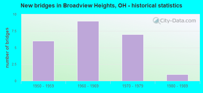
- New bridges - historical statistics
- 61950-1959
- 91960-1969
- 71970-1979
- 11980-1989

- Reconstructed bridges - Historical Statistics
- 21990-1999
- 12000-2009
- 22010-2019


- Bridge Condition - Deck
- 50.0%Very good
- 16.7%Good
- 16.7%Satisfactory
- 16.7%Poor

- Bridge Condition - Superstructure
- 8.3%Excellent
- 16.7%Very good
- 66.7%Good
- 8.3%Satisfactory

- Bridge Condition - Substructure
- 50.0%Very good
- 16.7%Good
- 33.3%Satisfactory

- Bridge Condition - Channel
- 33.3%Very good
- 66.7%Good
Find on map >> Show street view
Structure Number: 1805797, Location: JCT. SR-82 (Lat: 41.316281, Lng: -81.649181), Route carried "on" structure: Interstate 77, Year Built: 1971, Year Reconstructed: 2010, Status: Open, Structure Length: 4.82m (15.81ft), Average Daily Traffic: 37,686 (year 2015), Truck Traffic: 19%, Average Future Daily Traffic: 52,308 (year 2035), Design Load: HS 20+Mod, Features Intersected: SR 82 (1211) ROYALTON RD
Minimum Vertical Clearance: 30+ m (98+ ft), Kilometerpoint: 4.538, Lanes on structure: 3, Lanes under structure: 5, Base Highway Network: Yes, Owner: State Highway Agency, Approaching Roadway Width: 21.9m (71.9ft), Skew: 2 degrees, Material/Design: Steel continuous, Design/Construction: Stringer/Multi-beam, Number Of Spans In Main Unit: 2, Length of Maximum Span: 25.3m (83.0ft), Curb-To-Curb Width: 21.9m (71.9ft), Out-to-Out Width: 22.9m (75.1ft)
Condition: Deck: Very good, Superstructure: Good, Substructure: Very good, Operating Rating: 77.8 metric tons, Method Used To Determine Operating Rating: Load Factor (LF) rating reported by rating factor (RF) method using MS18 loading, Inventory Rating: 45.4 metric tons, Method Used To Determine Inventory Rating: Load Factor (LF) rating reported by rating factor (RF) method using MS18 loading, Structural Evaluation: Better than present minimum criteria, Deck Geometry: Superior to present desirable criteria, Underclear: Meets minimum limits, Approach Roadway Alignment: Equal to present desirable criteria, Designated Inspection Frequency: Every 24 months, Inspection Date: December 2021, Deck Structure Type: Concrete Cast-file-Place, Wearing Surface/Protective System: Wearing Surface: Monolithic Concrete
Find on map >> Show street view
Structure Number: 1805827, Location: JCT. SR-82 (Lat: 41.316631, Lng: -81.648631), Route carried "on" structure: Interstate 77, Year Built: 1971, Year Reconstructed: 2010, Status: Open, Structure Length: 4.82m (15.81ft), Average Daily Traffic: 37,686 (year 2015), Truck Traffic: 19%, Average Future Daily Traffic: 52,308 (year 2035), Design Load: HS 20+Mod, Features Intersected: SR 82 (1213) ROYALTON RD
Minimum Vertical Clearance: 30+ m (98+ ft), Kilometerpoint: 4.538, Lanes on structure: 3, Lanes under structure: 5, Base Highway Network: Yes, Owner: State Highway Agency, Approaching Roadway Width: 26.2m (86.0ft), Skew: 2 degrees, Material/Design: Steel continuous, Design/Construction: Stringer/Multi-beam, Number Of Spans In Main Unit: 2, Length of Maximum Span: 25.3m (83.0ft), Curb-To-Curb Width: 26.2m (86.0ft), Out-to-Out Width: 27.1m (88.9ft)
Condition: Deck: Very good, Superstructure: Good, Substructure: Very good, Operating Rating: 42.1 metric tons, Method Used To Determine Operating Rating: Allowable Stress (AS) rating reported by rating factor (RF) method using MS18 loading, Inventory Rating: 32.4 metric tons, Method Used To Determine Inventory Rating: Allowable Stress (AS) rating reported by rating factor (RF) method using MS18 loading, Structural Evaluation: Better than present minimum criteria, Deck Geometry: Superior to present desirable criteria, Underclear: Meets minimum limits, Approach Roadway Alignment: Equal to present desirable criteria, Designated Inspection Frequency: Every 24 months, Inspection Date: December 2021, Deck Structure Type: Concrete Cast-file-Place, Wearing Surface/Protective System: Wearing Surface: Monolithic Concrete
Find on map >> Show street view
Structure Number: 1805851, Location: .17 MI. N. OF JCT SR-82 (Lat: 41.319950, Lng: -81.648850), Route carried "on" structure: Interstate 77, Year Built: 1971, Status: Open, Structure Length: 0.70m (2.30ft), Average Daily Traffic: 75,372 (year 2015), Truck Traffic: 19%, Average Future Daily Traffic: 104,616 (year 2035), Design Load: HS 20+Mod, Features Intersected: CHIPPEWA CREEK
Minimum Vertical Clearance: 30+ m (98+ ft), Kilometerpoint: 4.973, Lanes on structure: 4, Base Highway Network: Yes, Owner: State Highway Agency, Approaching Roadway Width: 52.1m (170.9ft), Skew: 30 degrees, Material/Design: Concrete, Design/Construction: Culvert, Number Of Spans In Main Unit: 2, Length of Maximum Span: 3.0m (9.8ft)
Condition: Channel: Good, Culverts: Good, Operating Rating: 97.2 metric tons, Method Used To Determine Operating Rating: Load Factor (LF) rating reported by rating factor (RF) method using MS18 loading, Inventory Rating: 68.0 metric tons, Method Used To Determine Inventory Rating: Load Factor (LF) rating reported by rating factor (RF) method using MS18 loading, Structural Evaluation: Better than present minimum criteria, Waterway Adequacy: Equal to present desirable criteria, Approach Roadway Alignment: Equal to present desirable criteria, Designated Inspection Frequency: Every 12 months, Inspection Date: November 2021
Find on map >> Show street view
Structure Number: 1805886, Location: .63 MI. N. OF JCT. SR-82 (Lat: 41.325500, Lng: -81.649050), Route carried "on" structure: County highway 171, Year Built: 1971, Status: Open, Structure Length: 9.48m (31.10ft), Average Daily Traffic: 4,967 (year 2002), Truck Traffic: 1%, Average Future Daily Traffic: 6,894 (year 2022), Design Load: H 15, Features Intersected: IR-77 (UND HARRIS RD), Facility Carried by Structure: HARRIS RD
Minimum Vertical Clearance: 30+ m (98+ ft), Kilometerpoint: 0.002, Lanes on structure: 2, Lanes under structure: 4, Owner: State Highway Agency, Approaching Roadway Width: 7.3m (24.0ft), Skew: 1 degrees, Material/Design: Steel continuous, Design/Construction: Stringer/Multi-beam, Number Of Spans In Main Unit: 4, Length of Maximum Span: 27.4m (89.9ft), Curb or Sidewalk Widths: Left: 1.2m (3.9ft), Right: 1.2m (3.9ft), Curb-To-Curb Width: 8.5m (27.9ft), Out-to-Out Width: 11.7m (38.4ft)
Condition: Deck: Good, Superstructure: Good, Substructure: Good, Operating Rating: 35.6 metric tons, Method Used To Determine Operating Rating: Load and Resistance Factor Rating (LRFR) rating reported by rating factor(RF) method using HL-93 loadings, Inventory Rating: 25.9 metric tons, Method Used To Determine Inventory Rating: Load and Resistance Factor Rating (LRFR) rating reported by rating factor(RF) method using HL-93 loadings, Structural Evaluation: Equal to present minimum criteria, Deck Geometry: Meets minimum limits, Underclear: Meets minimum limits, Approach Roadway Alignment: Equal to present desirable criteria, Designated Inspection Frequency: Every 24 months, Inspection Date: Febuary 2021, Deck Structure Type: Concrete Cast-file-Place, Wearing Surface/Protective System: Wearing Surface: Monolithic Concrete
Find on map >> Show street view
Structure Number: 180594, Location: 1.44 MI. N. OF JCT. SR-82 (Lat: 41.337061, Lng: -81.649919), Route carried "on" structure: City street LACEY, Year Built: 1969, Status: Open, Structure Length: 8.60m (28.22ft), Average Daily Traffic: 1,000 (year 2002), Average Future Daily Traffic: 1,388 (year 2022), Design Load: H 15, Features Intersected: IR-77 (UND LACEY LANE)
Minimum Vertical Clearance: 30+ m (98+ ft), Kilometerpoint: 0.000, Lanes on structure: 2, Lanes under structure: 4, Owner: State Highway Agency, Approaching Roadway Width: 8.5m (27.9ft), Material/Design: Steel continuous, Design/Construction: Stringer/Multi-beam, Number Of Spans In Main Unit: 4, Length of Maximum Span: 25.0m (82.0ft), Curb or Sidewalk Widths: Left: 1.2m (3.9ft), Right: 1.2m (3.9ft), Curb-To-Curb Width: 8.5m (27.9ft), Out-to-Out Width: 11.7m (38.4ft)
Condition: Deck: Very good, Superstructure: Good, Substructure: Satisfactory, Operating Rating: 38.9 metric tons, Method Used To Determine Operating Rating: Load and Resistance Factor Rating (LRFR) rating reported by rating factor(RF) method using HL-93 loadings, Inventory Rating: 32.4 metric tons, Method Used To Determine Inventory Rating: Load and Resistance Factor Rating (LRFR) rating reported by rating factor(RF) method using HL-93 loadings, Structural Evaluation: Equal to present minimum criteria, Deck Geometry: Somewhat better than minimum adequacy, Underclear: Meets minimum limits, Approach Roadway Alignment: Equal to present desirable criteria, Designated Inspection Frequency: Every 12 months, Inspection Date: January 2021, Deck Structure Type: Concrete Cast-file-Place, Wearing Surface/Protective System: Wearing Surface: Integral Concrete
Find on map >> Show street view
Structure Number: 1805975, Location: 1.97 MI. N. OF JCT. SR-82 (Lat: 41.344839, Lng: -81.650350), Route carried "on" structure: County highway 57, Year Built: 1969, Status: Open, Structure Length: 8.66m (28.41ft), Average Daily Traffic: 5,941 (year 2016), Truck Traffic: 7%, Average Future Daily Traffic: 8,246 (year 2036), Design Load: HS 20, Features Intersected: IR-77 (UND WALLINGS RD.), Facility Carried by Structure: WALLINGS RD.
Minimum Vertical Clearance: 30+ m (98+ ft), Kilometerpoint: 7.854, Lanes on structure: 2, Lanes under structure: 4, Owner: State Highway Agency, Approaching Roadway Width: 8.2m (26.9ft), Material/Design: Steel continuous, Design/Construction: Stringer/Multi-beam, Number Of Spans In Main Unit: 4, Length of Maximum Span: 25.0m (82.0ft), Curb or Sidewalk Widths: Left: 1.2m (3.9ft), Right: 1.2m (3.9ft), Curb-To-Curb Width: 8.5m (27.9ft), Out-to-Out Width: 11.7m (38.4ft)
Condition: Deck: Poor, Superstructure: Satisfactory, Substructure: Satisfactory, Operating Rating: 55.1 metric tons, Method Used To Determine Operating Rating: Load Factor (LF) rating reported by rating factor (RF) method using MS18 loading, Inventory Rating: 32.4 metric tons, Method Used To Determine Inventory Rating: Load Factor (LF) rating reported by rating factor (RF) method using MS18 loading, Structural Evaluation: Equal to present minimum criteria, Deck Geometry: Meets minimum limits, Underclear: Meets minimum limits, Approach Roadway Alignment: Equal to present desirable criteria, Designated Inspection Frequency: Every 12 months, Inspection Date: May 2021, Deck Structure Type: Concrete Cast-file-Place, Wearing Surface/Protective System: Wearing Surface: Latex Concrete
Find on map >> Show street view
Structure Number: 1806009, Location: 2.41 MI. N. OF JCT. SR-82 (Lat: 41.351200, Lng: -81.649850), Route carried "on" structure: Interstate 77, Year Built: 1969, Status: Open, Structure Length: 4.75m (15.58ft), Average Daily Traffic: 42,630 (year 2015), Truck Traffic: 19%, Average Future Daily Traffic: 59,170 (year 2035), Design Load: HS 20+Mod, Features Intersected: CR 67 (SPRAGUE RD)
Minimum Vertical Clearance: 30+ m (98+ ft), Kilometerpoint: 8.417, Lanes on structure: 3, Lanes under structure: 2, Base Highway Network: Yes, Owner: State Highway Agency, Approaching Roadway Width: 19.5m (64.0ft), Material/Design: Steel continuous, Design/Construction: Stringer/Multi-beam, Number Of Spans In Main Unit: 3, Length of Maximum Span: 19.2m (63.0ft), Curb-To-Curb Width: 19.5m (64.0ft), Out-to-Out Width: 20.4m (66.9ft)
Condition: Deck: Very good, Superstructure: Very good, Substructure: Very good, Operating Rating: 42.1 metric tons, Method Used To Determine Operating Rating: Allowable Stress (AS) rating reported by rating factor (RF) method using MS18 loading, Inventory Rating: 32.4 metric tons, Method Used To Determine Inventory Rating: Allowable Stress (AS) rating reported by rating factor (RF) method using MS18 loading, Structural Evaluation: Equal to present desirable criteria, Deck Geometry: Superior to present desirable criteria, Underclear: High priority of corrective action, Approach Roadway Alignment: Equal to present desirable criteria, Length Of Structure Improvement: 4.75m (15.58ft), Designated Inspection Frequency: Every 24 months, Inspection Date: January 2021, Bridge Improvement Cost: $320,000, Roadway Improvement Cost: $36,000, Total Project Cost: $356,000, Deck Structure Type: Concrete Cast-file-Place, Wearing Surface/Protective System: Wearing Surface: Monolithic Concrete
Find on map >> Show street view
Structure Number: 1806033, Location: 2.41 MI N. OF JCT. SR-82 (Lat: 41.351081, Lng: -81.649411), Route carried "on" structure: Interstate 77, Year Built: 1969, Status: Open, Structure Length: 4.75m (15.58ft), Average Daily Traffic: 42,630 (year 2015), Truck Traffic: 19%, Average Future Daily Traffic: 59,170 (year 2035), Design Load: HS 20+Mod, Features Intersected: CR 67 (SPRAGUE RD)
Minimum Vertical Clearance: 30+ m (98+ ft), Kilometerpoint: 8.417, Lanes on structure: 3, Lanes under structure: 2, Base Highway Network: Yes, Owner: State Highway Agency, Approaching Roadway Width: 19.5m (64.0ft), Material/Design: Steel continuous, Design/Construction: Stringer/Multi-beam, Number Of Spans In Main Unit: 3, Length of Maximum Span: 19.2m (63.0ft), Curb-To-Curb Width: 19.7m (64.6ft), Out-to-Out Width: 19.7m (64.6ft)
Condition: Deck: Very good, Superstructure: Very good, Substructure: Very good, Operating Rating: 42.1 metric tons, Method Used To Determine Operating Rating: Allowable Stress (AS) rating reported by rating factor (RF) method using MS18 loading, Inventory Rating: 32.4 metric tons, Method Used To Determine Inventory Rating: Allowable Stress (AS) rating reported by rating factor (RF) method using MS18 loading, Structural Evaluation: Equal to present desirable criteria, Deck Geometry: Superior to present desirable criteria, Underclear: High priority of corrective action, Approach Roadway Alignment: Equal to present desirable criteria, Length Of Structure Improvement: 4.75m (15.58ft), Designated Inspection Frequency: Every 24 months, Inspection Date: January 2021, Bridge Improvement Cost: $320,000, Roadway Improvement Cost: $36,000, Total Project Cost: $356,000, Deck Structure Type: Concrete Cast-file-Place, Wearing Surface/Protective System: Wearing Surface: Monolithic Concrete
Find on map >> Show street view
Structure Number: 1829882, Location: 3.6 MILES WEST EXIT 173 (Lat: 41.301219, Lng: -81.701481), Route carried "on" structure: Interstate 80K, Year Built: 1956, Year Reconstructed: 2000, Status: Open, Structure Length: 8.90m (29.20ft), Average Daily Traffic: 12,800 (year 1972), Truck Traffic: 14%, Average Future Daily Traffic: 17,766 (year 1992), Design Load: HS 20+Mod, Features Intersected: N RYLTN BRKSVLLE PKWAY, Facility Carried by Structure: I80 OH TPK
Minimum Vertical Clearance: 30+ m (98+ ft), Kilometerpoint: 24.542, Lanes on structure: 6, Lanes under structure: 2, Base Highway Network: Yes, Toll: On toll road, Owner: State Toll Authority, Approaching Roadway Width: 36.6m (120.1ft), Skew: 36 degrees, Material/Design: Steel continuous, Design/Construction: Stringer/Multi-beam, Number Of Spans In Main Unit: 3, Length of Maximum Span: 25.9m (85.0ft), Curb-To-Curb Width: 37.4m (122.7ft), Out-to-Out Width: 38.3m (125.7ft)
Condition: Deck: Good, Superstructure: Good, Substructure: Satisfactory, Operating Rating: 38.9 metric tons, Method Used To Determine Operating Rating: Load Factor (LF) rating reported by rating factor (RF) method using MS18 loading, Inventory Rating: 22.7 metric tons, Method Used To Determine Inventory Rating: Load Factor (LF) rating reported by rating factor (RF) method using MS18 loading, Structural Evaluation: Somewhat better than minimum adequacy, Deck Geometry: Superior to present desirable criteria, Underclear: High priority of corrective action, Approach Roadway Alignment: Equal to present desirable criteria, Designated Inspection Frequency: Every 12 months, Inspection Date: June 2021, Deck Structure Type: Concrete Cast-file-Place, Wearing Surface/Protective System: Wearing Surface: Monolithic Concrete, Deck Protection: Epoxy Coated Reinforcing
Find on map >> Show street view
Structure Number: 1829912, Location: 8MI EAST OF EXIT 10 (Lat: 41.294981, Lng: -81.684750), Route carried "on" structure: State highway 176, Year Built: 1954, Year Reconstructed: 1997, Status: Open, Structure Length: 7.35m (24.11ft), Average Daily Traffic: 11,155 (year 2016), Truck Traffic: 4%, Average Future Daily Traffic: 15,483 (year 2036), Design Load: HS 20+Mod, Features Intersected: I80 OHIO TPK
Minimum Vertical Clearance: 30+ m (98+ ft), Kilometerpoint: 1.979, Lanes on structure: 2, Lanes under structure: 6, Owner: State Toll Authority, Approaching Roadway Width: 9.1m (29.9ft), Skew: 2 degrees, Material/Design: Steel continuous, Design/Construction: Stringer/Multi-beam, Number Of Spans In Main Unit: 4, Number Of Approach Spans: 2, Length of Maximum Span: 21.3m (69.9ft), Curb or Sidewalk Widths: Left: 1.2m (3.9ft), Right: 1.2m (3.9ft), Curb-To-Curb Width: 16.1m (52.8ft), Out-to-Out Width: 19.1m (62.7ft)
Condition: Deck: Satisfactory, Superstructure: Good, Substructure: Satisfactory, Operating Rating: 71.3 metric tons, Method Used To Determine Operating Rating: Load Factor (LF) rating reported by rating factor (RF) method using MS18 loading, Inventory Rating: 42.1 metric tons, Method Used To Determine Inventory Rating: Load Factor (LF) rating reported by rating factor (RF) method using MS18 loading, Structural Evaluation: Equal to present minimum criteria, Deck Geometry: Superior to present desirable criteria, Underclear: High priority of corrective action, Approach Roadway Alignment: Equal to present desirable criteria, Designated Inspection Frequency: Every 12 months, Inspection Date: June 2021, Deck Structure Type: Concrete Cast-file-Place, Wearing Surface/Protective System: Wearing Surface: Monolithic Concrete, Deck Protection: Epoxy Coated Reinforcing
Find on map >> Show street view
Structure Number: 1829939, Location: 8.1MI EAST OF EXIT 10 (Lat: 41.294761, Lng: -81.683950), Route carried "on" structure: County highway 63, Year Built: 1956, Year Reconstructed: 1998, Status: Open, Structure Length: 9.66m (31.69ft), Average Daily Traffic: 2,956 (year 2016), Truck Traffic: 7%, Average Future Daily Traffic: 4,103 (year 2036), Design Load: H 15, Features Intersected: I80 OHIO TPK, Facility Carried by Structure: EDGERTON RD
Minimum Vertical Clearance: 6.10m (20.01ft), Kilometerpoint: 9.213, Lanes on structure: 2, Lanes under structure: 6, Owner: State Toll Authority, Approaching Roadway Width: 10.7m (35.1ft), Skew: 4 degrees, Material/Design: Steel continuous, Design/Construction: Stringer/Multi-beam, Number Of Spans In Main Unit: 2, Number Of Approach Spans: 2, Length of Maximum Span: 28.3m (92.8ft), Curb-To-Curb Width: 10.6m (34.8ft), Out-to-Out Width: 11.5m (37.7ft)
Condition: Deck: Satisfactory, Superstructure: Good, Substructure: Good, Operating Rating: 42.1 metric tons, Method Used To Determine Operating Rating: Allowable Stress (AS) rating reported by rating factor (RF) method using MS18 loading, Inventory Rating: 32.4 metric tons, Method Used To Determine Inventory Rating: Allowable Stress (AS) rating reported by rating factor (RF) method using MS18 loading, Structural Evaluation: Better than present minimum criteria, Deck Geometry: Somewhat better than minimum adequacy, Underclear: High priority of corrective action, Approach Roadway Alignment: Equal to present desirable criteria, Designated Inspection Frequency: Every 12 months, Inspection Date: June 2021, Deck Structure Type: Concrete Cast-file-Place, Wearing Surface/Protective System: Wearing Surface: Monolithic Concrete, Deck Protection: Epoxy Coated Reinforcing
Find on map >> Show street view
Structure Number: 1831712, Location: 1096' NE OF ROYALTON RD (Lat: 41.322911, Lng: -81.644319), Route carried "on" structure: County highway C0171, Year Built: 1963, Status: Open, Structure Length: 1.97m (6.46ft), Average Daily Traffic: 3,056 (year 1999), Truck Traffic: 1%, Average Future Daily Traffic: 4,242 (year 2019), Design Load: HS 20+Mod, Features Intersected: CHIPPEWA CREEK, Facility Carried by Structure: HARRIS RD CR 171
Minimum Vertical Clearance: 30+ m (98+ ft), Kilometerpoint: 2.591, Lanes on structure: 2, Owner: County Highway Agency, Approaching Roadway Width: 11.0m (36.1ft), Skew: 2 degrees, Material/Design: Prestressed concrete, Design/Construction: Box Beam or Girders - Multiple, Number Of Spans In Main Unit: 1, Length of Maximum Span: 18.6m (61.0ft), Curb or Sidewalk Widths: Left: 1.2m (3.9ft), Right: 1.2m (3.9ft), Curb-To-Curb Width: 8.5m (27.9ft), Out-to-Out Width: 11.0m (36.1ft)
Condition: Deck: Very good, Superstructure: Excellent, Substructure: Very good, Channel: Good, Operating Rating: 59.6 metric tons, Method Used To Determine Operating Rating: Load and Resistance Factor Rating (LRFR) rating reported by rating factor(RF) method using HL-93 loadings, Inventory Rating: 46.0 metric tons, Method Used To Determine Inventory Rating: Load and Resistance Factor Rating (LRFR) rating reported by rating factor(RF) method using HL-93 loadings, Structural Evaluation: Equal to present desirable criteria, Deck Geometry: Meets minimum limits, Waterway Adequacy: Superior to present desirable criteria, Approach Roadway Alignment: Superior to present desirable criteria, Designated Inspection Frequency: Every 24 months, Inspection Date: October 2021, Deck Structure Type: Concrete Cast-file-Place, Wearing Surface/Protective System: Wearing Surface: Bituminous
Find on map >> Show street view
Structure Number: 1831933, Location: 145' E OF WILTSHIRE RD (Lat: 41.277211, Lng: -81.701769), Route carried "on" structure: County highway 127, Year Built: 1980, Status: Open, Structure Length: 1.92m (6.30ft), Average Daily Traffic: 6,052 (year 2015), Truck Traffic: 5%, Average Future Daily Traffic: 8,400 (year 2035), Design Load: HS 20+Mod, Features Intersected: EAST BR ROCKY RIVER
Minimum Vertical Clearance: 30+ m (98+ ft), Kilometerpoint: 11.990, Lanes on structure: 2, Owner: County Highway Agency, Approaching Roadway Width: 12.2m (40.0ft), Skew: 1 degrees, Material/Design: Steel, Design/Construction: Stringer/Multi-beam, Number Of Spans In Main Unit: 1, Length of Maximum Span: 18.3m (60.0ft), Curb-To-Curb Width: 12.2m (40.0ft), Out-to-Out Width: 12.2m (40.0ft)
Condition: Deck: Poor, Superstructure: Good, Substructure: Very good, Channel: Very good, Operating Rating: 69.7 metric tons, Method Used To Determine Operating Rating: Load Factor (LF) rating reported by rating factor (RF) method using MS18 loading, Inventory Rating: 41.8 metric tons, Method Used To Determine Inventory Rating: Load Factor (LF) rating reported by rating factor (RF) method using MS18 loading, Structural Evaluation: Better than present minimum criteria, Deck Geometry: Somewhat better than minimum adequacy, Waterway Adequacy: Superior to present desirable criteria, Approach Roadway Alignment: Superior to present desirable criteria, Designated Inspection Frequency: Every 12 months, Inspection Date: September 2021, Deck Structure Type: Concrete Cast-file-Place, Wearing Surface/Protective System: Wearing Surface: Bituminous
Find on map >> Show street view
Structure Number: 1805797, Location: JCT. SR-82 (Lat: 41.316281, Lng: -81.649181), Route carried "under" structure: State highway 82, Year Built: 1971, Structure Length: 0. m, Average Daily Traffic: 19,538 (year 2015), Truck Traffic: 7%, Features Intersected: I-77 SB (CUY-77-0282L), Facility Carried by Structure: IR 77 SB.
Minimum Vertical Clearance: 5.05m (16.57ft), Kilometerpoint: 19.489, Lanes on structure: 3, Lanes under structure: 5, Material/Design: Steel continuous, Design/Construction: Stringer/Multi-beam, Length of Maximum Span: 25.3m (83.0ft)
Find on map >> Show street view
Structure Number: 1805827, Location: JCT. SR-82 (Lat: 41.316631, Lng: -81.648631), Route carried "under" structure: State highway 82, Year Built: 1971, Structure Length: 0. m, Average Daily Traffic: 19,538 (year 2015), Truck Traffic: 7%, Features Intersected: I-71 NB (CUY-77-0282R), Facility Carried by Structure: IR 77 NB.
Minimum Vertical Clearance: 5.13m (16.83ft), Kilometerpoint: 19.521, Lanes on structure: 3, Lanes under structure: 5, Material/Design: Steel continuous, Design/Construction: Stringer/Multi-beam, Length of Maximum Span: 25.3m (83.0ft)
Find on map >> Show street view
Structure Number: 1805886, Location: .63 MI. N. OF JCT. SR-82 (Lat: 41.325500, Lng: -81.649050), Route carried "under" structure: Interstate 77, Year Built: 1971, Structure Length: 0. m, Average Daily Traffic: 77,635 (year 2016), Truck Traffic: 8%, Features Intersected: CR-171 (HARRIS RD), Facility Carried by Structure: HARRIS RD
Minimum Vertical Clearance: 7.11m (23.33ft), Kilometerpoint: 5.552, Lanes on structure: 2, Lanes under structure: 4, Material/Design: Steel continuous, Design/Construction: Stringer/Multi-beam, Length of Maximum Span: 27.4m (89.9ft)
Find on map >> Show street view
Structure Number: 180594, Location: 1.44 MI. N. OF JCT. SR-82 (Lat: 41.337061, Lng: -81.649919), Route carried "under" structure: Interstate 77, Year Built: 1969, Structure Length: 0. m, Average Daily Traffic: 77,635 (year 2016), Truck Traffic: 8%, Features Intersected: LACEY LANE, Facility Carried by Structure: LACEY LANE
Minimum Vertical Clearance: 5.23m (17.16ft), Kilometerpoint: 6.856, Lanes on structure: 2, Lanes under structure: 4, Material/Design: Steel continuous, Design/Construction: Stringer/Multi-beam, Length of Maximum Span: 25.0m (82.0ft)
Find on map >> Show street view
Structure Number: 1805975, Location: 1.97 MI. N. OF JCT. SR-82 (Lat: 41.344839, Lng: -81.650350), Route carried "under" structure: Interstate 77, Year Built: 1969, Structure Length: 0. m, Average Daily Traffic: 88,255 (year 2016), Truck Traffic: 8%, Features Intersected: CR-57 (WALLINGS RD), Facility Carried by Structure: WALLINGS RD.
Minimum Vertical Clearance: 5.21m (17.09ft), Kilometerpoint: 7.694, Lanes on structure: 2, Lanes under structure: 4, Material/Design: Steel continuous, Design/Construction: Stringer/Multi-beam, Length of Maximum Span: 25.0m (82.0ft)
Find on map >> Show street view
Structure Number: 1806009, Location: 2.41 MI. N. OF JCT. SR-82 (Lat: 41.351200, Lng: -81.649850), Route carried "under" structure: County highway 67, Year Built: 1969, Structure Length: 0. m, Average Daily Traffic: 2,630 (year 1968), Features Intersected: IR-77, Facility Carried by Structure: IR 77 SB.
Minimum Vertical Clearance: 4.67m (15.32ft), Kilometerpoint: 23.963, Lanes on structure: 3, Lanes under structure: 2, Material/Design: Steel continuous, Design/Construction: Stringer/Multi-beam, Length of Maximum Span: 19.2m (63.0ft)
Find on map >> Show street view
Structure Number: 1806033, Location: 2.41 MI N. OF JCT. SR-82 (Lat: 41.351081, Lng: -81.649411), Route carried "under" structure: County highway 67, Year Built: 1969, Structure Length: 0. m, Average Daily Traffic: 2,630 (year 1968), Features Intersected: I-77 NB, Facility Carried by Structure: IR 77 NB
Minimum Vertical Clearance: 4.60m (15.09ft), Kilometerpoint: 23.963, Lanes on structure: 3, Lanes under structure: 2, Material/Design: Steel continuous, Design/Construction: Stringer/Multi-beam, Length of Maximum Span: 19.2m (63.0ft)
Find on map >> Show street view
Structure Number: 1829882, Location: 3.6 MILES WEST EXIT 173 (Lat: 41.301219, Lng: -81.701481), Route carried "under" structure: City street NRBPK, Year Built: 1956, Structure Length: 0. m, Average Daily Traffic: 100 (year 1970), Features Intersected: I80 OHIO TPK, Facility Carried by Structure: N RYLTN BRKSVLLE P
Minimum Vertical Clearance: 4.09m (13.42ft), Kilometerpoint: 0.000, Lanes on structure: 6, Lanes under structure: 2, Material/Design: Steel continuous, Design/Construction: Stringer/Multi-beam, Length of Maximum Span: 25.9m (85.0ft)
Find on map >> Show street view
Structure Number: 1829912, Location: 8MI EAST OF EXIT 10 (Lat: 41.294981, Lng: -81.684750), Route carried "under" structure: Interstate 80K, Year Built: 1954, Structure Length: 0. m, Average Daily Traffic: 42,820 (year 2016), Truck Traffic: 27%, Features Intersected: SR-176 BROADVIEW RD, Facility Carried by Structure: I80 OH TPK
Minimum Vertical Clearance: 5.61m (18.41ft), Kilometerpoint: 272.784, Lanes on structure: 2, Lanes under structure: 6, Toll: On toll road, Material/Design: Steel continuous, Design/Construction: Stringer/Multi-beam, Length of Maximum Span: 21.3m (69.9ft)
Find on map >> Show street view
Structure Number: 1829939, Location: 8.1MI EAST OF EXIT 10 (Lat: 41.294761, Lng: -81.683950), Route carried "under" structure: Interstate 80K, Year Built: 1956, Structure Length: 0. m, Average Daily Traffic: 42,820 (year 2016), Truck Traffic: 27%, Features Intersected: EDGERTON RD CR-63, Facility Carried by Structure: I80 OH TPK
Minimum Vertical Clearance: 5.26m (17.26ft), Kilometerpoint: 26.264, Lanes on structure: 2, Lanes under structure: 6, Toll: On toll road, Material/Design: Steel continuous, Design/Construction: Stringer/Multi-beam, Length of Maximum Span: 28.3m (92.8ft)