Bridge Statistics for Broadview, Illinois (IL)
Condition, Traffic, Stress, Structural Evaluation, Project Costs
- National Bridge Inventory (NBI) Statistics
- 11Number of bridges
- 154ft / 46.9mTotal length
- $1,539,000Total costs
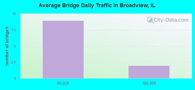
- 420,300Total average daily traffic
- 26,612Total average daily truck traffic
- National Bridge Inventory (NBI) Registered Bridges for Broadview
- No street view available for this location
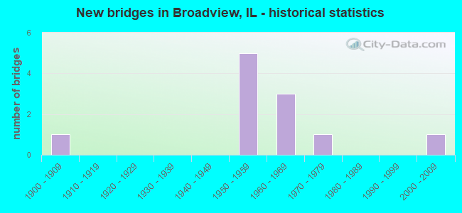
- New bridges - historical statistics
- 11900-1909
- 51950-1959
- 31960-1969
- 11970-1979
- 12000-2009
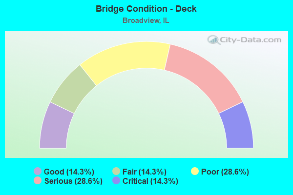
- Bridge Condition - Deck
- 14.3%Good
- 14.3%Fair
- 28.6%Poor
- 28.6%Serious
- 14.3%Critical
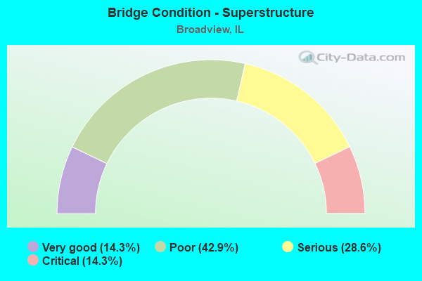
- Bridge Condition - Superstructure
- 14.3%Very good
- 42.9%Poor
- 28.6%Serious
- 14.3%Critical
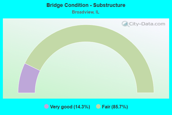
- Bridge Condition - Substructure
- 14.3%Very good
- 85.7%Fair
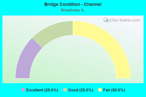
- Bridge Condition - Channel
- 25.0%Excellent
- 25.0%Good
- 50.0%Fair
Find on map >> Show street view
Structure Number: 160631, Location: 0.8 M E US 45 (Lat: 41.849089, Lng: -87.865339), Route carried "on" structure: Other road , Year Built: 1961, Year Reconstructed: 2021, Status: Open, Structure Length: 19.45m (63.81ft), Average Daily Traffic: 11,750 (year 2021), Truck Traffic: 3%, Average Future Daily Traffic: 43,672 (year 2032), Design Load: HS 20, Features Intersected: RR - IHB & GARDNER, Facility Carried by Structure: CERMAK RD (22ND ST
Minimum Vertical Clearance: 30+ m (98+ ft), Kilometerpoint: 4.361, Lanes on structure: 4, Lanes under structure: 2, Base Highway Network: Yes, Owner: State Highway Agency, Approaching Roadway Width: 14.6m (47.9ft), Skew: 30 degrees, Material/Design: Steel continuous, Design/Construction: Stringer/Multi-beam, Number Of Spans In Main Unit: 10, Length of Maximum Span: 27.5m (90.2ft), Curb or Sidewalk Widths: Left: 1.5m (4.9ft), Right: 1.5m (4.9ft), Curb-To-Curb Width: 16.8m (55.1ft), Out-to-Out Width: 21.4m (70.2ft)
Condition: Deck: Poor, Superstructure: Poor, Substructure: Fair, Operating Rating: 60.9 metric tons, Method Used To Determine Operating Rating: Load Factor (LF) rating reported by rating factor (RF) method using MS18 loading, Inventory Rating: 34.0 metric tons, Method Used To Determine Inventory Rating: Load Factor (LF) rating reported by rating factor (RF) method using MS18 loading, Structural Evaluation: Meets minimum limits, Deck Geometry: Somewhat better than minimum adequacy, Underclear: Superior to present desirable criteria, Approach Roadway Alignment: Equal to present minimum criteria, Designated Inspection Frequency: Every 12 months, Inspection Date: September 2021, Deck Structure Type: Concrete Cast-file-Place, Wearing Surface/Protective System: Wearing Surface: Integral Concrete
Find on map >> Show street view
Structure Number: 160632, Location: 1 M E US 45 (Lat: 41.849169, Lng: -87.862181), Route carried "on" structure: Other road , Year Built: 1961, Year Reconstructed: 2021, Status: Open, Structure Length: 6.05m (19.85ft), Average Daily Traffic: 16,050 (year 2018), Truck Traffic: 4%, Average Future Daily Traffic: 43,775 (year 2032), Design Load: HS 20, Features Intersected: 25TH AVE, Facility Carried by Structure: CERMAK RD (22ND ST
Minimum Vertical Clearance: 30+ m (98+ ft), Kilometerpoint: 4.764, Lanes on structure: 4, Lanes under structure: 4, Base Highway Network: Yes, Owner: State Highway Agency, Approaching Roadway Width: 14.6m (47.9ft), Skew: 30 degrees, Material/Design: Steel continuous, Design/Construction: Stringer/Multi-beam, Number Of Spans In Main Unit: 3, Length of Maximum Span: 23.2m (76.1ft), Curb or Sidewalk Widths: Left: 1.5m (4.9ft), Right: 1.5m (4.9ft), Curb-To-Curb Width: 16.8m (55.1ft), Out-to-Out Width: 21.4m (70.2ft)
Condition: Deck: Poor, Superstructure: Poor, Substructure: Fair, Operating Rating: 54.1 metric tons, Method Used To Determine Operating Rating: Load Factor (LF) rating reported by rating factor (RF) method using MS18 loading, Inventory Rating: 27.2 metric tons, Method Used To Determine Inventory Rating: Load Factor (LF) rating reported by rating factor (RF) method using MS18 loading, Structural Evaluation: Meets minimum limits, Deck Geometry: Somewhat better than minimum adequacy, Underclear: Equal to present minimum criteria, Approach Roadway Alignment: Equal to present minimum criteria, Designated Inspection Frequency: Every 12 months, Inspection Date: September 2021, Deck Structure Type: Concrete Cast-file-Place, Wearing Surface/Protective System: Wearing Surface: Integral Concrete
Find on map >> Show street view
Structure Number: 160633, Location: 1.4 M E US 45 (Lat: 41.849353, Lng: -87.856161), Route carried "on" structure: Other road , Year Built: 1959, Year Reconstructed: 2021, Status: Posted for load, Structure Length: 3.12m (10.24ft), Average Daily Traffic: 16,050 (year 2018), Truck Traffic: 4%, Average Future Daily Traffic: 43,775 (year 2032), Design Load: HS 20, Features Intersected: ADDISON CREEK, Facility Carried by Structure: CERMAK RD (22ND ST
Minimum Vertical Clearance: 30+ m (98+ ft), Kilometerpoint: 5.327, Lanes on structure: 4, Base Highway Network: Yes, Owner: State Highway Agency, Approaching Roadway Width: 15.8m (51.8ft), Skew: 20 degrees, Material/Design: Concrete continuous, Design/Construction: Slab, Number Of Spans In Main Unit: 3, Length of Maximum Span: 11.9m (39.0ft), Curb or Sidewalk Widths: Left: 1.5m (4.9ft), Right: 1.5m (4.9ft), Curb-To-Curb Width: 17.1m (56.1ft), Out-to-Out Width: 22.2m (72.8ft)
Condition: Deck: Serious, Superstructure: Serious, Substructure: Fair, Channel: Fair, Operating Rating: 49.9 metric tons, Method Used To Determine Operating Rating: Load and Resistance Factor Rating (LRFR) rating reported by rating factor(RF) method using HL-93 loadings, Inventory Rating: 38.9 metric tons, Method Used To Determine Inventory Rating: Load and Resistance Factor Rating (LRFR) rating reported by rating factor(RF) method using HL-93 loadings, Structural Evaluation: High priority of corrective action, Deck Geometry: Somewhat better than minimum adequacy, Waterway Adequacy: Equal to present desirable criteria, Approach Roadway Alignment: Equal to present desirable criteria, Designated Inspection Frequency: Every 12 months, Other Special Inspection Frequency: Every 12 months, Inspection Date: June 2021, Other Special Inspection Date: June 2021, Deck Structure Type: Concrete Cast-file-Place, Wearing Surface/Protective System: Wearing Surface: Integral Concrete
Find on map >> Show street view
Structure Number: 160689, Location: 1.8 M S I-290 (Lat: 41.844425, Lng: -87.861992), Route carried "on" structure: Other road , Year Built: 1953, Status: Posted for load, Structure Length: 3.15m (10.33ft), Average Daily Traffic: 9,150 (year 2018), Truck Traffic: 6%, Average Future Daily Traffic: 6,592 (year 2032), Design Load: HS 20, Features Intersected: SALT CREEK, Facility Carried by Structure: 25TH AVE
Minimum Vertical Clearance: 30+ m (98+ ft), Kilometerpoint: 13.808, Lanes on structure: 2, Base Highway Network: Yes, Owner: State Highway Agency, Approaching Roadway Width: 7.3m (24.0ft), Skew: 2 degrees, Material/Design: Concrete continuous, Design/Construction: Slab, Number Of Spans In Main Unit: 3, Length of Maximum Span: 12.0m (39.4ft), Curb or Sidewalk Widths: Left: 1.5m (4.9ft), Right: 1.5m (4.9ft), Curb-To-Curb Width: 14.6m (47.9ft), Out-to-Out Width: 18.3m (60.0ft)
Condition: Deck: Serious, Superstructure: Serious, Substructure: Fair, Channel: Fair, Operating Rating: 20.1 metric tons, Method Used To Determine Operating Rating: Load Factor (LF) rating reported by rating factor (RF) method using MS18 loading, Inventory Rating: 12.0 metric tons, Method Used To Determine Inventory Rating: Load Factor (LF) rating reported by rating factor (RF) method using MS18 loading, Structural Evaluation: High priority of replacement, Deck Geometry: Superior to present desirable criteria, Waterway Adequacy: Equal to present desirable criteria, Approach Roadway Alignment: Equal to present desirable criteria, Bridge Posting: Required (Relationship of Operating Rating to Maximum Legal Load: > 39.9% below), Length Of Structure Improvement: 4.18m (13.71ft), Designated Inspection Frequency: Every 12 months, Inspection Date: August 2021, Bridge Improvement Cost: $818,000, Roadway Improvement Cost: $82,000, Total Project Cost: $1,227,000, Deck Structure Type: Concrete Cast-file-Place, Wearing Surface/Protective System: Wearing Surface: Other
Find on map >> Show street view
Structure Number: 160694, Location: 2.5 M W IL 43 (Lat: 41.870881, Lng: -87.853311), Route carried "on" structure: Other road , Year Built: 1951, Year Reconstructed: 1984, Status: Open, Structure Length: 6.39m (20.96ft), Average Daily Traffic: 8,400 (year 2018), Truck Traffic: 4%, Average Future Daily Traffic: 10,403 (year 2032), Design Load: HS 20, Features Intersected: I-290 IKE, Facility Carried by Structure: 17TH AVE
Minimum Vertical Clearance: 30+ m (98+ ft), Kilometerpoint: 1.223, Lanes on structure: 4, Lanes under structure: 6, Owner: State Highway Agency, Approaching Roadway Width: 15.2m (49.9ft), Material/Design: Steel continuous, Design/Construction: Stringer/Multi-beam, Number Of Spans In Main Unit: 4, Length of Maximum Span: 17.5m (57.4ft), Curb or Sidewalk Widths: Left: 1.5m (4.9ft), Right: 1.5m (4.9ft), Curb-To-Curb Width: 15.2m (49.9ft), Out-to-Out Width: 18.9m (62.0ft)
Condition: Deck: Fair, Superstructure: Poor, Substructure: Fair, Operating Rating: 50.9 metric tons, Method Used To Determine Operating Rating: Load Factor (LF) rating reported by rating factor (RF) method using MS18 loading, Inventory Rating: 30.5 metric tons, Method Used To Determine Inventory Rating: Load Factor (LF) rating reported by rating factor (RF) method using MS18 loading, Structural Evaluation: Meets minimum limits, Deck Geometry: High priority of corrective action, Underclear: High priority of corrective action, Approach Roadway Alignment: Better than present minimum criteria, Length Of Structure Improvement: 6.40m (21.00ft), Designated Inspection Frequency: Every 12 months, Inspection Date: April 2021, Bridge Improvement Cost: $260,000, Roadway Improvement Cost: $13,000, Total Project Cost: $312,000, Deck Structure Type: Concrete Cast-file-Place, Wearing Surface/Protective System: Wearing Surface: Other
Find on map >> Show street view
Structure Number: 16272, Location: 0.9 M S I-290 (Lat: 41.859233, Lng: -87.862642), Route carried "on" structure: Other road , Year Built: 2000, Status: Open, Structure Length: 6.27m (20.57ft), Average Daily Traffic: 16,200 (year 2018), Truck Traffic: 9%, Average Future Daily Traffic: 14,523 (year 2032), Features Intersected: ADDISON CREEK, Facility Carried by Structure: 25TH AVE
Minimum Vertical Clearance: 30+ m (98+ ft), Kilometerpoint: 12.231, Lanes on structure: 4, Base Highway Network: Yes, Owner: State Highway Agency, Approaching Roadway Width: 15.2m (49.9ft), Skew: 4 degrees, Material/Design: Steel continuous, Design/Construction: Stringer/Multi-beam, Number Of Spans In Main Unit: 3, Length of Maximum Span: 21.4m (70.2ft), Curb or Sidewalk Widths: Left: 2.1m (6.9ft), Right: 2.1m (6.9ft), Curb-To-Curb Width: 15.2m (49.9ft), Out-to-Out Width: 20.0m (65.6ft)
Condition: Deck: Good, Superstructure: Very good, Substructure: Very good, Channel: Excellent, Operating Rating: 73.2 metric tons, Method Used To Determine Operating Rating: Load Factor (LF) rating reported by rating factor (RF) method using MS18 loading, Inventory Rating: 44.1 metric tons, Method Used To Determine Inventory Rating: Load Factor (LF) rating reported by rating factor (RF) method using MS18 loading, Structural Evaluation: Equal to present desirable criteria, Deck Geometry: High priority of corrective action, Waterway Adequacy: Superior to present desirable criteria, Approach Roadway Alignment: Equal to present desirable criteria, Designated Inspection Frequency: Every 48 months, Inspection Date: May 2020, Deck Structure Type: Concrete Cast-file-Place, Wearing Surface/Protective System: Deck Protection: Epoxy Coated Reinforcing
Find on map >> Show street view
Structure Number: 16665, Location: 0.22MI.W. OF 17TH AV (Lat: 41.851142, Lng: -87.856983), Route carried "on" structure: City street , Year Built: 1974, Status: Posted for load, Structure Length: 2.50m (8.20ft), Average Daily Traffic: 850 (year 2018), Truck Traffic: 7%, Average Future Daily Traffic: 390 (year 2032), Design Load: HS 20, Features Intersected: ADDISON CR, Facility Carried by Structure: 21ST ST
Minimum Vertical Clearance: 30+ m (98+ ft), Kilometerpoint: 0.435, Lanes on structure: 2, Owner: City or Municipal Highway Agency, Approaching Roadway Width: 11.0m (36.1ft), Skew: 1 degrees, Material/Design: Prestressed concrete, Design/Construction: Box Beam or Girders - Multiple, Number Of Spans In Main Unit: 3, Length of Maximum Span: 9.4m (30.8ft), Curb or Sidewalk Widths: Left: 1.5m (4.9ft), Right: 1.5m (4.9ft), Curb-To-Curb Width: 10.9m (35.8ft), Out-to-Out Width: 14.6m (47.9ft)
Condition: Deck: Critical, Superstructure: Critical, Substructure: Fair, Channel: Good, Operating Rating: 19.4 metric tons, Method Used To Determine Operating Rating: Load Factor (LF) rating reported by rating factor (RF) method using MS18 loading, Inventory Rating: 11.7 metric tons, Method Used To Determine Inventory Rating: Load Factor (LF) rating reported by rating factor (RF) method using MS18 loading, Structural Evaluation: High priority of replacement, Deck Geometry: Equal to present minimum criteria, Waterway Adequacy: Superior to present desirable criteria, Approach Roadway Alignment: Equal to present desirable criteria, Bridge Posting: Required (Relationship of Operating Rating to Maximum Legal Load: > 39.9% below), Designated Inspection Frequency: Every 24 months, Other Special Inspection Frequency: Every 6 months, Inspection Date: November 2020, Other Special Inspection Date: December 2021, Deck Structure Type: Concrete Precast Panels, Wearing Surface/Protective System: Wearing Surface: Bituminous
Find on map >> Show street view
Structure Number: 160089, Location: 0.8 M E US 45 P20 (Lat: 41.870939, Lng: -87.866414), Route carried "under" structure: Interstate 290, Year Built: 1952, Structure Length: 0. m, Average Daily Traffic: 157,700 (year 2021), Truck Traffic: 7%, Features Intersected: I-290 IKE, Facility Carried by Structure: IHB RR
Minimum Vertical Clearance: 4.45m (14.60ft), Kilometerpoint: 29.579, Lanes under structure: 6, Material/Design: Steel continuous, Design/Construction: Girder and Floorbeam System, Length of Maximum Span: 18.0m (59.1ft)
Find on map >> Show street view
Structure Number: 160632, Location: 1 M E US 45 (Lat: 41.849169, Lng: -87.862181), Route carried "under" structure: Other road , Year Built: 1961, Structure Length: 0. m, Average Daily Traffic: 9,150 (year 2018), Truck Traffic: 6%, Features Intersected: 25TH AVE, Facility Carried by Structure: CERMAK RD (22ND ST
Minimum Vertical Clearance: 4.39m (14.40ft), Kilometerpoint: 13.277, Lanes on structure: 4, Lanes under structure: 4, Material/Design: Steel continuous, Design/Construction: Stringer/Multi-beam, Length of Maximum Span: 23.2m (76.1ft)
Find on map >> Show street view
Structure Number: 160687, Location: 0.8 M S I290 P20 (Lat: 41.860422, Lng: -87.862683), Route carried "under" structure: Other road , Year Built: 1900, Structure Length: 0. m, Average Daily Traffic: 16,200 (year 2018), Truck Traffic: 9%, Features Intersected: 25TH AVE, Facility Carried by Structure: CC RR
Minimum Vertical Clearance: 4.32m (14.17ft), Kilometerpoint: 12.005, Lanes under structure: 4, Material/Design: Steel, Length of Maximum Span: 18.3m (60.0ft)
Find on map >> Show street view
Structure Number: 160694, Location: 2.5 M W IL 43 (Lat: 41.870881, Lng: -87.853311), Route carried "under" structure: Interstate 290, Year Built: 1951, Structure Length: 0. m, Average Daily Traffic: 158,800 (year 2021), Truck Traffic: 6%, Features Intersected: I-290 IKE, Facility Carried by Structure: 17TH AVE
Minimum Vertical Clearance: 4.39m (14.40ft), Kilometerpoint: 30.657, Lanes on structure: 4, Lanes under structure: 6, Material/Design: Steel continuous, Design/Construction: Stringer/Multi-beam, Length of Maximum Span: 17.5m (57.4ft)