Bridge Statistics for Brookville, Ohio (OH)
Condition, Traffic, Stress, Structural Evaluation, Project Costs
- National Bridge Inventory (NBI) Statistics
- 31Number of bridges
- 253ft / 76.6mTotal length
- 245,819Total average daily traffic
- 57,784Total average daily truck traffic
- National Bridge Inventory (NBI) Registered Bridges for Brookville
- No street view available for this location
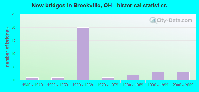
- New bridges - historical statistics
- 11940-1949
- 11950-1959
- 201960-1969
- 11970-1979
- 21980-1989
- 31990-1999
- 32000-2009

- Reconstructed bridges - Historical Statistics
- 11980-1989
- 01990-1999
- 12000-2009
- 22010-2019


- Bridge Condition - Deck
- 13.6%Excellent
- 13.6%Very good
- 40.9%Good
- 4.5%Satisfactory
- 22.7%Fair
- 4.5%Poor

- Bridge Condition - Superstructure
- 13.6%Excellent
- 22.7%Very good
- 36.4%Good
- 22.7%Fair
- 4.5%Poor

- Bridge Condition - Substructure
- 4.5%Excellent
- 27.3%Very good
- 54.5%Good
- 13.6%Satisfactory

- Bridge Condition - Channel
- 17.6%Very good
- 52.9%Good
- 29.4%Satisfactory

- Bridge Condition - Culverts
- 50.0%Excellent
- 50.0%Good
Find on map >> Show street view
Structure Number: 5704685, Location: 1.06MI.E. OF PREBLE CO. (Lat: 39.837731, Lng: -84.463681), Route carried "on" structure: County highway C0003, Year Built: 1964, Status: Open, Structure Length: 8.56m (28.08ft), Average Daily Traffic: 358 (year 2015), Truck Traffic: 8%, Average Future Daily Traffic: 51,420 (year 2035), Design Load: H 15, Features Intersected: I70, Facility Carried by Structure: NUMBER NINE RD.
Minimum Vertical Clearance: 30+ m (98+ ft), Kilometerpoint: 0.821, Lanes on structure: 2, Lanes under structure: 4, Owner: State Highway Agency, Approaching Roadway Width: 8.8m (28.9ft), Material/Design: Steel continuous, Design/Construction: Stringer/Multi-beam, Number Of Spans In Main Unit: 4, Length of Maximum Span: 25.0m (82.0ft), Curb-To-Curb Width: 8.0m (26.2ft), Out-to-Out Width: 9.4m (30.8ft)
Condition: Deck: Good, Superstructure: Good, Substructure: Good, Operating Rating: 25.9 metric tons, Method Used To Determine Operating Rating: Allowable Stress (AS) rating reported by rating factor (RF) method using MS18 loading, Inventory Rating: 19.4 metric tons, Method Used To Determine Inventory Rating: Allowable Stress (AS) rating reported by rating factor (RF) method using MS18 loading, Structural Evaluation: Somewhat better than minimum adequacy, Deck Geometry: Somewhat better than minimum adequacy, Underclear: Somewhat better than minimum adequacy, Approach Roadway Alignment: Equal to present desirable criteria, Designated Inspection Frequency: Every 24 months, Inspection Date: August 2021, Deck Structure Type: Concrete Cast-file-Place, Wearing Surface/Protective System: Wearing Surface: Latex Concrete
Find on map >> Show street view
Structure Number: 5704715, Location: 2.95MI.E. OF PREBLE CO. (Lat: 39.844500, Lng: -84.430731), Route carried "on" structure: Interstate 70, Year Built: 1964, Status: Open, Structure Length: 6.13m (20.11ft), Average Daily Traffic: 18,523 (year 2015), Truck Traffic: 24%, Average Future Daily Traffic: 25,710 (year 2035), Design Load: HS 20, Features Intersected: C22(UPR LEW SALM RD)
Minimum Vertical Clearance: 30+ m (98+ ft), Kilometerpoint: 4.748, Lanes on structure: 2, Lanes under structure: 2, Base Highway Network: Yes, Owner: State Highway Agency, Approaching Roadway Width: 7.3m (24.0ft), Skew: 1 degrees, Material/Design: Steel continuous, Design/Construction: Stringer/Multi-beam, Number Of Spans In Main Unit: 4, Length of Maximum Span: 15.9m (52.2ft), Curb-To-Curb Width: 12.1m (39.7ft), Out-to-Out Width: 13.5m (44.3ft)
Condition: Deck: Good, Superstructure: Very good, Substructure: Very good, Operating Rating: 32.4 metric tons, Method Used To Determine Operating Rating: Allowable Stress (AS) rating reported by rating factor (RF) method using MS18 loading, Inventory Rating: 25.9 metric tons, Method Used To Determine Inventory Rating: Allowable Stress (AS) rating reported by rating factor (RF) method using MS18 loading, Structural Evaluation: Equal to present minimum criteria, Deck Geometry: Equal to present minimum criteria, Underclear: Superior to present desirable criteria, Approach Roadway Alignment: Superior to present desirable criteria, Designated Inspection Frequency: Every 24 months, Inspection Date: August 2021, Deck Structure Type: Concrete Cast-file-Place, Wearing Surface/Protective System: Wearing Surface: Integral Concrete
Find on map >> Show street view
Structure Number: 5704774, Location: 2.95MI.E. OF PREBLE CO. (Lat: 39.844350, Lng: -84.430369), Route carried "on" structure: Interstate 70, Year Built: 1964, Status: Open, Structure Length: 6.13m (20.11ft), Average Daily Traffic: 18,523 (year 2015), Truck Traffic: 24%, Average Future Daily Traffic: 25,710 (year 2035), Design Load: HS 20, Features Intersected: C22(UPR LEW SALM RD)
Minimum Vertical Clearance: 30+ m (98+ ft), Kilometerpoint: 4.748, Lanes on structure: 2, Lanes under structure: 2, Base Highway Network: Yes, Owner: State Highway Agency, Approaching Roadway Width: 7.3m (24.0ft), Skew: 1 degrees, Material/Design: Steel continuous, Design/Construction: Stringer/Multi-beam, Number Of Spans In Main Unit: 4, Length of Maximum Span: 15.9m (52.2ft), Curb-To-Curb Width: 12.1m (39.7ft), Out-to-Out Width: 13.5m (44.3ft)
Condition: Deck: Satisfactory, Superstructure: Very good, Substructure: Very good, Operating Rating: 64.8 metric tons, Method Used To Determine Operating Rating: Load Factor (LF) rating reported by rating factor (RF) method using MS18 loading, Inventory Rating: 38.9 metric tons, Method Used To Determine Inventory Rating: Load Factor (LF) rating reported by rating factor (RF) method using MS18 loading, Structural Evaluation: Equal to present desirable criteria, Deck Geometry: Equal to present minimum criteria, Underclear: Superior to present desirable criteria, Approach Roadway Alignment: Superior to present desirable criteria, Designated Inspection Frequency: Every 12 months, Inspection Date: August 2021, Deck Structure Type: Concrete Cast-file-Place, Wearing Surface/Protective System: Wearing Surface: Integral Concrete
Find on map >> Show street view
Structure Number: 5704804, Location: 3.2MI.W.OF JCT. SB-SR-49 (Lat: 39.848111, Lng: -84.425081), Route carried "on" structure: County highway C0009, Year Built: 1964, Year Reconstructed: 2018, Status: Open, Structure Length: 11.46m (37.60ft), Average Daily Traffic: 8,140 (year 2018), Truck Traffic: 4%, Average Future Daily Traffic: 9,906 (year 2038), Design Load: HL 93, Features Intersected: I70, Facility Carried by Structure: ARLINGTON RD. (C9)
Minimum Vertical Clearance: 30+ m (98+ ft), Kilometerpoint: 19.634, Lanes on structure: 2, Lanes under structure: 4, Owner: State Highway Agency, Approaching Roadway Width: 11.0m (36.1ft), Skew: 4 degrees, Material/Design: Steel continuous, Design/Construction: Stringer/Multi-beam, Number Of Spans In Main Unit: 4, Length of Maximum Span: 33.2m (108.9ft), Curb or Sidewalk Widths: Left: 1.5m (4.9ft), Right: 0.0m, Curb-To-Curb Width: 13.4m (44.0ft), Out-to-Out Width: 15.8m (51.8ft)
Condition: Deck: Excellent, Superstructure: Excellent, Substructure: Excellent, Operating Rating: 45.4 metric tons, Method Used To Determine Operating Rating: Load and Resistance Factor Rating (LRFR) rating reported by rating factor(RF) method using HL-93 loadings, Inventory Rating: 35.6 metric tons, Method Used To Determine Inventory Rating: Load and Resistance Factor Rating (LRFR) rating reported by rating factor(RF) method using HL-93 loadings, Structural Evaluation: Superior to present desirable criteria, Deck Geometry: Equal to present minimum criteria, Underclear: Equal to present minimum criteria, Approach Roadway Alignment: Superior to present desirable criteria, Designated Inspection Frequency: Every 24 months, Inspection Date: August 2021, Deck Structure Type: Concrete Cast-file-Place, Wearing Surface/Protective System: Wearing Surface: Monolithic Concrete, Deck Protection: Epoxy Coated Reinforcing
Find on map >> Show street view
Structure Number: 5704928, Location: 2.02MI.W.OF JCT SB-SR-49 (Lat: 39.856781, Lng: -84.406869), Route carried "on" structure: County highway C0011, Year Built: 1964, Status: Open, Structure Length: 8.20m (26.90ft), Average Daily Traffic: 959 (year 2015), Truck Traffic: 8%, Average Future Daily Traffic: 62,328 (year 2035), Design Load: H 15, Features Intersected: I70, Facility Carried by Structure: C-11
Minimum Vertical Clearance: 30+ m (98+ ft), Kilometerpoint: 2.575, Lanes on structure: 2, Lanes under structure: 4, Owner: State Highway Agency, Approaching Roadway Width: 7.3m (24.0ft), Material/Design: Steel continuous, Design/Construction: Stringer/Multi-beam, Number Of Spans In Main Unit: 4, Length of Maximum Span: 22.9m (75.1ft), Curb-To-Curb Width: 8.0m (26.2ft), Out-to-Out Width: 9.4m (30.8ft)
Condition: Deck: Good, Superstructure: Good, Substructure: Good, Operating Rating: 48.6 metric tons, Method Used To Determine Operating Rating: Load Factor (LF) rating reported by rating factor (RF) method using MS18 loading, Inventory Rating: 29.2 metric tons, Method Used To Determine Inventory Rating: Load Factor (LF) rating reported by rating factor (RF) method using MS18 loading, Structural Evaluation: Better than present minimum criteria, Deck Geometry: Somewhat better than minimum adequacy, Underclear: Somewhat better than minimum adequacy, Approach Roadway Alignment: Superior to present desirable criteria, Designated Inspection Frequency: Every 24 months, Inspection Date: August 2021, Deck Structure Type: Concrete Cast-file-Place, Wearing Surface/Protective System: Wearing Surface: Integral Concrete
Find on map >> Show street view
Structure Number: 5704952, Location: 1.01MI.W.OF JCT SB-SR-49 (Lat: 39.855719, Lng: -84.388011), Route carried "on" structure: County highway T0023, Year Built: 1964, Status: Open, Structure Length: 7.32m (24.02ft), Average Daily Traffic: 224 (year 2015), Truck Traffic: 5%, Average Future Daily Traffic: 62,328 (year 2035), Design Load: H 15, Features Intersected: I70, Facility Carried by Structure: WELLBAUM RD.(T23)
Minimum Vertical Clearance: 30+ m (98+ ft), Kilometerpoint: 4.989, Lanes on structure: 2, Lanes under structure: 4, Owner: State Highway Agency, Approaching Roadway Width: 7.3m (24.0ft), Material/Design: Steel continuous, Design/Construction: Stringer/Multi-beam, Number Of Spans In Main Unit: 4, Length of Maximum Span: 20.4m (66.9ft), Curb-To-Curb Width: 8.0m (26.2ft), Out-to-Out Width: 9.4m (30.8ft)
Condition: Deck: Good, Superstructure: Good, Substructure: Good, Operating Rating: 48.6 metric tons, Method Used To Determine Operating Rating: Load Factor (LF) rating reported by rating factor (RF) method using MS18 loading, Inventory Rating: 29.2 metric tons, Method Used To Determine Inventory Rating: Load Factor (LF) rating reported by rating factor (RF) method using MS18 loading, Structural Evaluation: Better than present minimum criteria, Deck Geometry: Somewhat better than minimum adequacy, Underclear: Somewhat better than minimum adequacy, Approach Roadway Alignment: Superior to present desirable criteria, Designated Inspection Frequency: Every 24 months, Inspection Date: August 2021, Deck Structure Type: Concrete Cast-file-Place, Wearing Surface/Protective System: Wearing Surface: Latex Concrete
Find on map >> Show street view
Structure Number: 5732344, Location: .6 MILES SOUTH OF SR40 (Lat: 39.860011, Lng: -84.388150), Route carried "on" structure: County highway T0223, Year Built: 1965, Status: Open, Structure Length: 1.28m (4.20ft), Average Daily Traffic: 305 (year 2017), Truck Traffic: 4%, Average Future Daily Traffic: 423 (year 2037), Design Load: HS 15, Features Intersected: Razor Run
Minimum Vertical Clearance: 30+ m (98+ ft), Kilometerpoint: 3.299, Lanes on structure: 2, Owner: County Highway Agency, Approaching Roadway Width: 6.1m (20.0ft), Material/Design: Prestressed concrete, Design/Construction: Box Beam or Girders - Multiple, Number Of Spans In Main Unit: 1, Length of Maximum Span: 11.9m (39.0ft), Curb-To-Curb Width: 7.3m (24.0ft), Out-to-Out Width: 7.3m (24.0ft)
Condition: Deck: Fair, Superstructure: Fair, Substructure: Good, Channel: Good, Operating Rating: 71.3 metric tons, Method Used To Determine Operating Rating: Load Factor (LF) rating reported by rating factor (RF) method using MS18 loading, Inventory Rating: 42.1 metric tons, Method Used To Determine Inventory Rating: Load Factor (LF) rating reported by rating factor (RF) method using MS18 loading, Structural Evaluation: Somewhat better than minimum adequacy, Deck Geometry: Somewhat better than minimum adequacy, Waterway Adequacy: Better than present minimum criteria, Approach Roadway Alignment: Equal to present desirable criteria, Designated Inspection Frequency: Every 12 months, Inspection Date: July 2021, Deck Structure Type: Concrete Cast-file-Place, Wearing Surface/Protective System: Wearing Surface: Bituminous
Find on map >> Show street view
Structure Number: 5748062, Location: 4.1 MILES NORTH OF SR 35 (Lat: 39.804981, Lng: -84.395400), Route carried "on" structure: County highway C0015, Year Built: 2003, Status: Open, Structure Length: 1.55m (5.09ft), Average Daily Traffic: 1,201 (year 2017), Truck Traffic: 5%, Average Future Daily Traffic: 1,667 (year 2037), Design Load: HS 25 or greater, Features Intersected: trib to Wolf Creek
Minimum Vertical Clearance: 30+ m (98+ ft), Kilometerpoint: 6.663, Lanes on structure: 2, Owner: County Highway Agency, Approaching Roadway Width: 7.9m (25.9ft), Material/Design: Prestressed concrete, Design/Construction: Box Beam or Girders - Multiple, Number Of Spans In Main Unit: 1, Length of Maximum Span: 15.2m (49.9ft), Curb-To-Curb Width: 9.8m (32.2ft), Out-to-Out Width: 9.8m (32.2ft)
Condition: Deck: Very good, Superstructure: Very good, Substructure: Very good, Channel: Very good, Operating Rating: 87.5 metric tons, Method Used To Determine Operating Rating: Load Factor (LF) rating reported by rating factor (RF) method using MS18 loading, Inventory Rating: 51.8 metric tons, Method Used To Determine Inventory Rating: Load Factor (LF) rating reported by rating factor (RF) method using MS18 loading, Structural Evaluation: Equal to present desirable criteria, Deck Geometry: Somewhat better than minimum adequacy, Waterway Adequacy: Better than present minimum criteria, Approach Roadway Alignment: Equal to present desirable criteria, Designated Inspection Frequency: Every 24 months, Inspection Date: November 2021, Deck Structure Type: Concrete Cast-file-Place, Wearing Surface/Protective System: Wearing Surface: Bituminous, Membrane: Preformed Fabric, Deck Protection: Other
Find on map >> Show street view
Structure Number: 5748089, Location: .3 MI S BRKVLL PYRMONT RD (Lat: 39.815539, Lng: -84.442611), Route carried "on" structure: County highway C0007, Year Built: 1962, Status: Open, Structure Length: 1.40m (4.59ft), Average Daily Traffic: 803 (year 2017), Truck Traffic: 2%, Average Future Daily Traffic: 1,115 (year 2037), Design Load: HS 20, Features Intersected: Tom's Run, Facility Carried by Structure: Crawford Tom's Run
Minimum Vertical Clearance: 30+ m (98+ ft), Kilometerpoint: 7.982, Lanes on structure: 2, Owner: County Highway Agency, Approaching Roadway Width: 6.1m (20.0ft), Skew: 2 degrees, Material/Design: Prestressed concrete, Design/Construction: Box Beam or Girders - Multiple, Number Of Spans In Main Unit: 1, Length of Maximum Span: 12.8m (42.0ft), Curb-To-Curb Width: 8.5m (27.9ft), Out-to-Out Width: 8.5m (27.9ft)
Condition: Deck: Fair, Superstructure: Fair, Substructure: Good, Channel: Good, Operating Rating: 97.2 metric tons, Method Used To Determine Operating Rating: Load Factor (LF) rating reported by rating factor (RF) method using MS18 loading, Inventory Rating: 61.6 metric tons, Method Used To Determine Inventory Rating: Load Factor (LF) rating reported by rating factor (RF) method using MS18 loading, Structural Evaluation: Somewhat better than minimum adequacy, Deck Geometry: Somewhat better than minimum adequacy, Waterway Adequacy: Better than present minimum criteria, Approach Roadway Alignment: Equal to present minimum criteria, Designated Inspection Frequency: Every 12 months, Inspection Date: November 2021, Deck Structure Type: Concrete Cast-file-Place, Wearing Surface/Protective System: Wearing Surface: Bituminous
Find on map >> Show street view
Structure Number: 57481, Location: .1 MI E OF PREBLE CO LINE (Lat: 39.810119, Lng: -84.480581), Route carried "on" structure: County highway C0034, Year Built: 2004, Status: Open, Structure Length: 0.68m (2.23ft), Average Daily Traffic: 263 (year 2017), Truck Traffic: 8%, Average Future Daily Traffic: 365 (year 2037), Design Load: HS 25 or greater, Features Intersected: Lesley Run, Facility Carried by Structure: Providence Road C0
Minimum Vertical Clearance: 30+ m (98+ ft), Kilometerpoint: 0.241, Lanes on structure: 2, Owner: County Highway Agency, Approaching Roadway Width: 6.1m (20.0ft), Skew: 1 degrees, Material/Design: Concrete, Design/Construction: Culvert, Number Of Spans In Main Unit: 1, Length of Maximum Span: 6.2m (20.3ft)
Condition: Channel: Very good, Culverts: Excellent, Operating Rating: 42.1 metric tons, Method Used To Determine Operating Rating: Load and Resistance Factor Rating (LRFR) rating reported by rating factor(RF) method using HL-93 loadings, Inventory Rating: 32.4 metric tons, Method Used To Determine Inventory Rating: Load and Resistance Factor Rating (LRFR) rating reported by rating factor(RF) method using HL-93 loadings, Structural Evaluation: Equal to present desirable criteria, Waterway Adequacy: Better than present minimum criteria, Approach Roadway Alignment: Equal to present desirable criteria, Designated Inspection Frequency: Every 24 months, Inspection Date: November 2021
Find on map >> Show street view
Structure Number: 5748135, Location: .5 MI S OF AIR HILL ROAD (Lat: 39.810000, Lng: -84.395489), Route carried "on" structure: County highway C0015, Year Built: 1947, Year Reconstructed: 2012, Status: Open, Structure Length: 1.22m (4.00ft), Average Daily Traffic: 856 (year 2016), Truck Traffic: 6%, Average Future Daily Traffic: 1,188 (year 2036), Design Load: H 20, Features Intersected: Wolf Creek
Minimum Vertical Clearance: 30+ m (98+ ft), Kilometerpoint: 7.178, Lanes on structure: 2, Owner: County Highway Agency, Approaching Roadway Width: 7.3m (24.0ft), Material/Design: Steel, Design/Construction: Stringer/Multi-beam, Number Of Spans In Main Unit: 1, Length of Maximum Span: 11.6m (38.1ft), Curb-To-Curb Width: 8.5m (27.9ft), Out-to-Out Width: 8.5m (27.9ft)
Condition: Deck: Excellent, Superstructure: Excellent, Substructure: Satisfactory, Channel: Satisfactory, Operating Rating: 77.8 metric tons, Method Used To Determine Operating Rating: Load and Resistance Factor Rating (LRFR) rating reported by rating factor(RF) method using HL-93 loadings, Inventory Rating: 61.6 metric tons, Method Used To Determine Inventory Rating: Load and Resistance Factor Rating (LRFR) rating reported by rating factor(RF) method using HL-93 loadings, Structural Evaluation: Equal to present minimum criteria, Deck Geometry: Somewhat better than minimum adequacy, Waterway Adequacy: Better than present minimum criteria, Approach Roadway Alignment: Equal to present minimum criteria, Designated Inspection Frequency: Every 12 months, Inspection Date: November 2021, Deck Structure Type: Corrugated Steel, Wearing Surface/Protective System: Wearing Surface: Monolithic Concrete
Find on map >> Show street view
Structure Number: 5748143, Location: 2.2 MI W DIAMOND MILL RD (Lat: 39.818081, Lng: -84.407000), Route carried "on" structure: County highway T0026, Year Built: 1964, Status: Open, Structure Length: 1.46m (4.79ft), Average Daily Traffic: 512 (year 2017), Truck Traffic: 9%, Average Future Daily Traffic: 711 (year 2037), Design Load: HS 20+Mod, Features Intersected: WOLF CREEK
Minimum Vertical Clearance: 30+ m (98+ ft), Kilometerpoint: 3.042, Lanes on structure: 2, Owner: County Highway Agency, Approaching Roadway Width: 6.7m (22.0ft), Material/Design: Prestressed concrete, Design/Construction: Box Beam or Girders - Multiple, Number Of Spans In Main Unit: 1, Length of Maximum Span: 13.7m (44.9ft), Curb-To-Curb Width: 7.3m (24.0ft), Out-to-Out Width: 7.3m (24.0ft)
Condition: Deck: Poor, Superstructure: Poor, Substructure: Good, Channel: Good, Operating Rating: 55.1 metric tons, Method Used To Determine Operating Rating: Load Factor (LF) rating reported by rating factor (RF) method using MS18 loading, Inventory Rating: 32.4 metric tons, Method Used To Determine Inventory Rating: Load Factor (LF) rating reported by rating factor (RF) method using MS18 loading, Structural Evaluation: Meets minimum limits, Deck Geometry: Meets minimum limits, Waterway Adequacy: Better than present minimum criteria, Approach Roadway Alignment: Equal to present minimum criteria, Designated Inspection Frequency: Every 12 months, Inspection Date: November 2021, Deck Structure Type: Concrete Cast-file-Place, Wearing Surface/Protective System: Wearing Surface: Bituminous, Membrane: Built-up
Find on map >> Show street view
Structure Number: 5748216, Location: 250 FT E OF CRAWFORD RD (Lat: 39.807889, Lng: -84.441689), Route carried "on" structure: County highway C0034, Year Built: 1960, Year Reconstructed: 1991, Status: Open, Structure Length: 0.88m (2.89ft), Average Daily Traffic: 263 (year 2017), Truck Traffic: 11%, Average Future Daily Traffic: 365 (year 2037), Design Load: HS 25 or greater, Features Intersected: Tom's Run, Facility Carried by Structure: Providence Road
Minimum Vertical Clearance: 30+ m (98+ ft), Kilometerpoint: 3.637, Lanes on structure: 2, Owner: County Highway Agency, Approaching Roadway Width: 7.0m (23.0ft), Skew: 1 degrees, Material/Design: Prestressed concrete, Design/Construction: Box Beam or Girders - Multiple, Number Of Spans In Main Unit: 1, Length of Maximum Span: 8.2m (26.9ft), Curb-To-Curb Width: 8.5m (27.9ft), Out-to-Out Width: 8.5m (27.9ft)
Condition: Deck: Good, Superstructure: Good, Substructure: Satisfactory, Channel: Good, Operating Rating: 97.2 metric tons, Method Used To Determine Operating Rating: Load Factor (LF) rating reported by rating factor (RF) method using MS18 loading, Inventory Rating: 61.6 metric tons, Method Used To Determine Inventory Rating: Load Factor (LF) rating reported by rating factor (RF) method using MS18 loading, Structural Evaluation: Equal to present minimum criteria, Deck Geometry: Equal to present minimum criteria, Waterway Adequacy: Equal to present desirable criteria, Approach Roadway Alignment: Equal to present desirable criteria, Designated Inspection Frequency: Every 12 months, Inspection Date: November 2021, Deck Structure Type: Concrete Cast-file-Place, Wearing Surface/Protective System: Wearing Surface: Bituminous, Membrane: Built-up
Find on map >> Show street view
Structure Number: 5748305, Location: 750 FT W OF CRAWFORD RD (Lat: 39.788581, Lng: -84.445269), Route carried "on" structure: County highway T0056, Year Built: 1964, Status: Open, Structure Length: 1.43m (4.69ft), Average Daily Traffic: 341 (year 2017), Truck Traffic: 4%, Average Future Daily Traffic: 473 (year 2037), Design Load: HS 20+Mod, Features Intersected: Tom's Run
Minimum Vertical Clearance: 30+ m (98+ ft), Kilometerpoint: 3.219, Lanes on structure: 2, Owner: County Highway Agency, Approaching Roadway Width: 6.4m (21.0ft), Material/Design: Prestressed concrete, Design/Construction: Box Beam or Girders - Multiple, Number Of Spans In Main Unit: 1, Length of Maximum Span: 13.4m (44.0ft), Curb-To-Curb Width: 7.3m (24.0ft), Out-to-Out Width: 7.3m (24.0ft)
Condition: Deck: Fair, Superstructure: Fair, Substructure: Good, Channel: Satisfactory, Operating Rating: 61.6 metric tons, Method Used To Determine Operating Rating: Load Factor (LF) rating reported by rating factor (RF) method using MS18 loading, Inventory Rating: 35.6 metric tons, Method Used To Determine Inventory Rating: Load Factor (LF) rating reported by rating factor (RF) method using MS18 loading, Structural Evaluation: Somewhat better than minimum adequacy, Deck Geometry: Somewhat better than minimum adequacy, Waterway Adequacy: Equal to present minimum criteria, Approach Roadway Alignment: Equal to present minimum criteria, Designated Inspection Frequency: Every 12 months, Inspection Date: November 2021, Deck Structure Type: Concrete Cast-file-Place, Wearing Surface/Protective System: Wearing Surface: Bituminous
Find on map >> Show street view
Structure Number: 5748348, Location: 1.3 MI W JHNSVLL BRKVL RD (Lat: 39.819731, Lng: -84.446581), Route carried "on" structure: County highway C0031, Year Built: 1982, Status: Open, Structure Length: 0.88m (2.89ft), Average Daily Traffic: 1,364 (year 2015), Truck Traffic: 6%, Average Future Daily Traffic: 1,893 (year 2035), Design Load: HS 20+Mod, Features Intersected: Tom's Run, Facility Carried by Structure: Brookville Pyrmnt
Minimum Vertical Clearance: 30+ m (98+ ft), Kilometerpoint: 4.265, Lanes on structure: 2, Owner: County Highway Agency, Approaching Roadway Width: 6.1m (20.0ft), Material/Design: Prestressed concrete, Design/Construction: Box Beam or Girders - Multiple, Number Of Spans In Main Unit: 1, Length of Maximum Span: 7.9m (25.9ft), Curb-To-Curb Width: 9.8m (32.2ft), Out-to-Out Width: 9.8m (32.2ft)
Condition: Deck: Good, Superstructure: Good, Substructure: Very good, Channel: Good, Operating Rating: 77.8 metric tons, Method Used To Determine Operating Rating: Load Factor (LF) rating reported by rating factor (RF) method using MS18 loading, Inventory Rating: 48.6 metric tons, Method Used To Determine Inventory Rating: Load Factor (LF) rating reported by rating factor (RF) method using MS18 loading, Structural Evaluation: Better than present minimum criteria, Deck Geometry: Somewhat better than minimum adequacy, Waterway Adequacy: Equal to present desirable criteria, Approach Roadway Alignment: Equal to present desirable criteria, Designated Inspection Frequency: Every 24 months, Inspection Date: November 2021, Deck Structure Type: Concrete Cast-file-Place, Wearing Surface/Protective System: Wearing Surface: Bituminous
Find on map >> Show street view
Structure Number: 5748399, Location: 4.1 MILES NORTH OF SR35 (Lat: 39.806811, Lng: -84.442489), Route carried "on" structure: County highway C0007, Year Built: 1992, Status: Open, Structure Length: 1.34m (4.40ft), Average Daily Traffic: 343 (year 2017), Truck Traffic: 4%, Average Future Daily Traffic: 476 (year 2037), Design Load: HS 20+Mod, Features Intersected: Tom's Run, Facility Carried by Structure: Crawford-Tom's Run
Minimum Vertical Clearance: 30+ m (98+ ft), Kilometerpoint: 7.017, Lanes on structure: 2, Owner: County Highway Agency, Approaching Roadway Width: 6.1m (20.0ft), Skew: 5 degrees, Material/Design: Steel, Design/Construction: Stringer/Multi-beam, Number Of Spans In Main Unit: 1, Length of Maximum Span: 11.9m (39.0ft), Curb-To-Curb Width: 9.1m (29.9ft), Out-to-Out Width: 9.1m (29.9ft)
Condition: Deck: Good, Superstructure: Good, Substructure: Good, Channel: Good, Operating Rating: 42.1 metric tons, Method Used To Determine Operating Rating: Load Factor (LF) rating reported by rating factor (RF) method using MS18 loading, Inventory Rating: 32.4 metric tons, Method Used To Determine Inventory Rating: Load Factor (LF) rating reported by rating factor (RF) method using MS18 loading, Structural Evaluation: Better than present minimum criteria, Deck Geometry: Equal to present minimum criteria, Waterway Adequacy: Equal to present desirable criteria, Approach Roadway Alignment: Equal to present desirable criteria, Designated Inspection Frequency: Every 24 months, Inspection Date: November 2021, Deck Structure Type: Corrugated Steel, Wearing Surface/Protective System: Wearing Surface: Bituminous, Membrane: Built-up, Deck Protection: Epoxy Coated Reinforcing
Find on map >> Show street view
Structure Number: 5748445, Location: 1 MILE WEST OF CLAYTON RD (Lat: 39.788911, Lng: -84.415019), Route carried "on" structure: County highway T0056, Year Built: 1994, Status: Open, Structure Length: 0.73m (2.40ft), Average Daily Traffic: 341 (year 2017), Truck Traffic: 4%, Average Future Daily Traffic: 473 (year 2037), Design Load: HS 25 or greater, Features Intersected: Bear Creek
Minimum Vertical Clearance: 30+ m (98+ ft), Kilometerpoint: 5.922, Lanes on structure: 2, Owner: County Highway Agency, Approaching Roadway Width: 6.7m (22.0ft), Skew: 1 degrees, Material/Design: Concrete, Design/Construction: Frame, Number Of Spans In Main Unit: 1, Length of Maximum Span: 6.7m (22.0ft), Curb-To-Curb Width: 8.5m (27.9ft), Out-to-Out Width: 12.8m (42.0ft)
Condition: Deck: Very good, Superstructure: Very good, Substructure: Very good, Channel: Very good, Operating Rating: 32.4 metric tons, Method Used To Determine Operating Rating: Load Factor (LF) rating reported by rating factor (RF) method using MS18 loading, Inventory Rating: 19.4 metric tons, Method Used To Determine Inventory Rating: Load Factor (LF) rating reported by rating factor (RF) method using MS18 loading, Structural Evaluation: Somewhat better than minimum adequacy, Deck Geometry: Equal to present minimum criteria, Waterway Adequacy: Equal to present desirable criteria, Approach Roadway Alignment: Equal to present desirable criteria, Designated Inspection Frequency: Every 24 months, Inspection Date: November 2021, Deck Structure Type: Concrete Cast-file-Place, Wearing Surface/Protective System: Wearing Surface: Bituminous, Membrane: Built-up
Find on map >> Show street view
Structure Number: 5766443, Location: .6 MI SE OF ARLINGTON RD (Lat: 39.836381, Lng: -84.414831), Route carried "on" structure: City street M0230, Year Built: 1959, Status: Open, Structure Length: 1.19m (3.90ft), Average Daily Traffic: 4,483 (year 2017), Truck Traffic: 2%, Average Future Daily Traffic: 6,222 (year 2037), Design Load: HS 20+Mod, Features Intersected: Wolf Creek
Minimum Vertical Clearance: 30+ m (98+ ft), Kilometerpoint: 1.049, Lanes on structure: 2, Owner: County Highway Agency, Approaching Roadway Width: 12.2m (40.0ft), Material/Design: Concrete, Design/Construction: Slab, Number Of Spans In Main Unit: 1, Length of Maximum Span: 11.0m (36.1ft), Curb or Sidewalk Widths: Left: 1.5m (4.9ft), Right: 1.5m (4.9ft), Curb-To-Curb Width: 12.2m (40.0ft), Out-to-Out Width: 15.9m (52.2ft)
Condition: Deck: Good, Superstructure: Good, Substructure: Good, Channel: Satisfactory, Operating Rating: 47.2 metric tons, Method Used To Determine Operating Rating: Field evaluation and documented engineering judgment, Inventory Rating: 36.3 metric tons, Method Used To Determine Inventory Rating: Field evaluation and documented engineering judgment, Structural Evaluation: Better than present minimum criteria, Deck Geometry: Equal to present minimum criteria, Waterway Adequacy: Better than present minimum criteria, Approach Roadway Alignment: Equal to present desirable criteria, Designated Inspection Frequency: Every 24 months, Inspection Date: March 2021, Deck Structure Type: Concrete Cast-file-Place, Wearing Surface/Protective System: Wearing Surface: Bituminous
Find on map >> Show street view
Structure Number: 5766451, Location: 200 FT W OF WOLF CREEK PK (Lat: 39.833789, Lng: -84.413869), Route carried "on" structure: City street M5001, Year Built: 1979, Status: Open, Structure Length: 1.55m (5.09ft), Average Daily Traffic: 386 (year 2021), Truck Traffic: 2%, Average Future Daily Traffic: 1,000 (year 2041), Design Load: HS 20+Mod, Features Intersected: WOLF CREEK, Facility Carried by Structure: MCKINLEY STREET
Minimum Vertical Clearance: 30+ m (98+ ft), Kilometerpoint: 0.097, Lanes on structure: 2, Owner: City or Municipal Highway Agency, Approaching Roadway Width: 10.7m (35.1ft), Material/Design: Prestressed concrete, Design/Construction: Box Beam or Girders - Multiple, Number Of Spans In Main Unit: 1, Length of Maximum Span: 14.9m (48.9ft), Curb or Sidewalk Widths: Left: 1.5m (4.9ft), Right: 0.0m, Curb-To-Curb Width: 7.3m (24.0ft), Out-to-Out Width: 7.3m (24.0ft)
Condition: Deck: Fair, Superstructure: Fair, Substructure: Good, Channel: Satisfactory, Operating Rating: 51.8 metric tons, Method Used To Determine Operating Rating: Load Factor (LF) rating reported by rating factor (RF) method using MS18 loading, Inventory Rating: 32.4 metric tons, Method Used To Determine Inventory Rating: Load Factor (LF) rating reported by rating factor (RF) method using MS18 loading, Structural Evaluation: Somewhat better than minimum adequacy, Deck Geometry: Somewhat better than minimum adequacy, Waterway Adequacy: Equal to present desirable criteria, Approach Roadway Alignment: Equal to present desirable criteria, Designated Inspection Frequency: Every 12 months, Inspection Date: April 2021, Deck Structure Type: Other, Wearing Surface/Protective System: Wearing Surface: Bituminous, Membrane: Built-up
Find on map >> Show street view
Structure Number: 5766478, Location: AT WOLF CREEK PIKE (Lat: 39.831481, Lng: -84.411711), Route carried "on" structure: City street M0024, Year Built: 1967, Status: Open, Structure Length: 1.86m (6.10ft), Average Daily Traffic: 2,941 (year 2017), Truck Traffic: 6%, Average Future Daily Traffic: 4,082 (year 2037), Design Load: HS 20, Features Intersected: WOLF CREEK
Minimum Vertical Clearance: 30+ m (98+ ft), Kilometerpoint: 6.421, Lanes on structure: 3, Owner: County Highway Agency, Approaching Roadway Width: 12.5m (41.0ft), Skew: 3 degrees, Material/Design: Prestressed concrete, Design/Construction: Box Beam or Girders - Multiple, Number Of Spans In Main Unit: 1, Length of Maximum Span: 17.4m (57.1ft), Curb or Sidewalk Widths: Left: 1.2m (3.9ft), Right: 1.2m (3.9ft), Curb-To-Curb Width: 13.9m (45.6ft), Out-to-Out Width: 17.6m (57.7ft)
Condition: Deck: Fair, Superstructure: Fair, Substructure: Good, Channel: Good, Operating Rating: 61.6 metric tons, Method Used To Determine Operating Rating: Load Factor (LF) rating reported by rating factor (RF) method using MS18 loading, Inventory Rating: 35.6 metric tons, Method Used To Determine Inventory Rating: Load Factor (LF) rating reported by rating factor (RF) method using MS18 loading, Structural Evaluation: Somewhat better than minimum adequacy, Deck Geometry: Somewhat better than minimum adequacy, Waterway Adequacy: Better than present minimum criteria, Approach Roadway Alignment: Equal to present desirable criteria, Designated Inspection Frequency: Every 12 months, Inspection Date: March 2021, Deck Structure Type: Concrete Cast-file-Place, Wearing Surface/Protective System: Wearing Surface: Bituminous
Find on map >> Show street view
Structure Number: 5766516, Location: 200 FT EAST ARLINGTON RD (Lat: 39.845731, Lng: -84.424050), Route carried "on" structure: City street M0022, Year Built: 1985, Status: Open, Structure Length: 0.70m (2.30ft), Average Daily Traffic: 3,016 (year 2017), Truck Traffic: 4%, Average Future Daily Traffic: 4,186 (year 2037), Design Load: HS 20+Mod, Features Intersected: Wolf Creek, Facility Carried by Structure: Uppr Lewisbrg Salm
Minimum Vertical Clearance: 30+ m (98+ ft), Kilometerpoint: 5.359, Lanes on structure: 2, Owner: County Highway Agency, Approaching Roadway Width: 12.5m (41.0ft), Material/Design: Concrete, Design/Construction: Culvert, Number Of Spans In Main Unit: 1, Length of Maximum Span: 6.7m (22.0ft), Curb or Sidewalk Widths: Left: 1.2m (3.9ft), Right: 0.0m
Condition: Channel: Satisfactory, Culverts: Good, Operating Rating: 77.8 metric tons, Method Used To Determine Operating Rating: Load Factor (LF) rating reported by rating factor (RF) method using MS18 loading, Inventory Rating: 45.4 metric tons, Method Used To Determine Inventory Rating: Load Factor (LF) rating reported by rating factor (RF) method using MS18 loading, Structural Evaluation: Better than present minimum criteria, Waterway Adequacy: Better than present minimum criteria, Approach Roadway Alignment: Equal to present desirable criteria, Designated Inspection Frequency: Every 24 months, Inspection Date: March 2021
Find on map >> Show street view
Structure Number: 5766532, Location: 250FT W OF WOLF CRK ST (Lat: 39.834819, Lng: -84.414881), Route carried "on" structure: City street M0031, Year Built: 2002, Status: Open, Structure Length: 1.40m (4.59ft), Average Daily Traffic: 1,311 (year 2017), Truck Traffic: 9%, Average Future Daily Traffic: 1,820 (year 2037), Design Load: HS 20+Mod, Features Intersected: WOLF CREEK
Minimum Vertical Clearance: 30+ m (98+ ft), Kilometerpoint: 7.570, Lanes on structure: 2, Owner: County Highway Agency, Approaching Roadway Width: 9.8m (32.2ft), Material/Design: Prestressed concrete, Design/Construction: Box Beam or Girders - Multiple, Number Of Spans In Main Unit: 1, Length of Maximum Span: 12.8m (42.0ft), Curb or Sidewalk Widths: Left: 1.8m (5.9ft), Right: 1.8m (5.9ft), Curb-To-Curb Width: 9.8m (32.2ft), Out-to-Out Width: 14.0m (45.9ft)
Condition: Deck: Excellent, Superstructure: Excellent, Substructure: Very good, Channel: Good, Operating Rating: 74.5 metric tons, Method Used To Determine Operating Rating: Load Factor (LF) rating reported by rating factor (RF) method using MS18 loading, Inventory Rating: 45.4 metric tons, Method Used To Determine Inventory Rating: Load Factor (LF) rating reported by rating factor (RF) method using MS18 loading, Structural Evaluation: Equal to present desirable criteria, Deck Geometry: Somewhat better than minimum adequacy, Waterway Adequacy: Equal to present desirable criteria, Approach Roadway Alignment: Equal to present minimum criteria, Designated Inspection Frequency: Every 24 months, Inspection Date: March 2021, Deck Structure Type: Concrete Cast-file-Place, Wearing Surface/Protective System: Wearing Surface: Monolithic Concrete, Membrane: Preformed Fabric, Deck Protection: Epoxy Coated Reinforcing
Find on map >> Show street view
Structure Number: 6801625, Location: AT MON CO LINE (Lat: 39.837519, Lng: -84.483700), Route carried "on" structure: County highway C0001, Year Built: 1964, Status: Open, Structure Length: 8.53m (27.99ft), Average Daily Traffic: 798 (year 2015), Truck Traffic: 8%, Average Future Daily Traffic: 54,566 (year 2035), Design Load: H 15, Features Intersected: I70, Facility Carried by Structure: C57
Minimum Vertical Clearance: 30+ m (98+ ft), Kilometerpoint: 29.129, Lanes on structure: 2, Lanes under structure: 4, Owner: State Highway Agency, Approaching Roadway Width: 8.8m (28.9ft), Material/Design: Steel continuous, Design/Construction: Stringer/Multi-beam, Number Of Spans In Main Unit: 4, Length of Maximum Span: 24.8m (81.4ft), Curb-To-Curb Width: 7.3m (24.0ft), Out-to-Out Width: 9.4m (30.8ft)
Condition: Deck: Good, Superstructure: Good, Substructure: Good, Operating Rating: 38.9 metric tons, Method Used To Determine Operating Rating: Load and Resistance Factor Rating (LRFR) rating reported by rating factor(RF) method using HL-93 loadings, Inventory Rating: 29.2 metric tons, Method Used To Determine Inventory Rating: Load and Resistance Factor Rating (LRFR) rating reported by rating factor(RF) method using HL-93 loadings, Structural Evaluation: Better than present minimum criteria, Deck Geometry: Meets minimum limits, Underclear: Somewhat better than minimum adequacy, Approach Roadway Alignment: Superior to present desirable criteria, Designated Inspection Frequency: Every 24 months, Inspection Date: September 2021, Deck Structure Type: Concrete Cast-file-Place, Wearing Surface/Protective System: Wearing Surface: Latex Concrete
Find on map >> Show street view
Structure Number: 6830447, Location: 500' EAST OF COUNTY LINE (Lat: 39.794231, Lng: -84.484169), Route carried "on" structure: County highway C0056, Year Built: 1997, Year Reconstructed: 2016, Status: Open, Structure Length: 0.76m (2.49ft), Average Daily Traffic: 1,380 (year 2016), Truck Traffic: 4%, Average Future Daily Traffic: 1,915 (year 2036), Design Load: HS 20, Features Intersected: LESLEY RUN, Facility Carried by Structure: LEXINGTON SALEM
Minimum Vertical Clearance: 30+ m (98+ ft), Kilometerpoint: 13.631, Lanes on structure: 2, Owner: County Highway Agency, Approaching Roadway Width: 8.5m (27.9ft), Skew: 3 degrees, Material/Design: Concrete, Design/Construction: Box Beam or Girders - Multiple, Number Of Spans In Main Unit: 1, Length of Maximum Span: 6.4m (21.0ft), Curb-To-Curb Width: 8.5m (27.9ft), Out-to-Out Width: 8.5m (27.9ft)
Condition: Deck: Very good, Superstructure: Very good, Substructure: Satisfactory, Channel: Good, Operating Rating: 97.2 metric tons, Method Used To Determine Operating Rating: Load Factor (LF) rating reported by rating factor (RF) method using MS18 loading, Inventory Rating: 94.0 metric tons, Method Used To Determine Inventory Rating: Load Factor (LF) rating reported by rating factor (RF) method using MS18 loading, Structural Evaluation: Equal to present minimum criteria, Deck Geometry: Somewhat better than minimum adequacy, Waterway Adequacy: Equal to present desirable criteria, Approach Roadway Alignment: Equal to present desirable criteria, Designated Inspection Frequency: Every 12 months, Inspection Date: August 2021, Deck Structure Type: Concrete Cast-file-Place, Wearing Surface/Protective System: Wearing Surface: Bituminous, Membrane: Built-up
Find on map >> Show street view
Structure Number: 5704685, Location: 1.06MI.E. OF PREBLE CO. (Lat: 39.837731, Lng: -84.463681), Route carried "under" structure: Interstate 70, Year Built: 1964, Structure Length: 0. m, Average Daily Traffic: 37,046 (year 2015), Truck Traffic: 24%, Features Intersected: C3(NUMBER NINE ROAD), Facility Carried by Structure: NUMBER NINE RD.
Minimum Vertical Clearance: 4.95m (16.24ft), Kilometerpoint: 1.706, Lanes on structure: 2, Lanes under structure: 4, Material/Design: Steel continuous, Design/Construction: Stringer/Multi-beam, Length of Maximum Span: 25.0m (82.0ft)
Find on map >> Show street view
Structure Number: 5704715, Location: 2.95MI.E. OF PREBLE CO. (Lat: 39.844500, Lng: -84.430731), Route carried "under" structure: County highway C0022, Year Built: 1964, Structure Length: 0. m, Average Daily Traffic: 1,938 (year 2015), Truck Traffic: 5%, Features Intersected: I70*W, Facility Carried by Structure: IR-70
Minimum Vertical Clearance: 7.06m (23.16ft), Kilometerpoint: 4.345, Lanes on structure: 2, Lanes under structure: 2, Material/Design: Steel continuous, Design/Construction: Stringer/Multi-beam, Length of Maximum Span: 15.9m (52.2ft)
Find on map >> Show street view
Structure Number: 5704774, Location: 2.95MI.E. OF PREBLE CO. (Lat: 39.844350, Lng: -84.430369), Route carried "under" structure: County highway C0022, Year Built: 1964, Structure Length: 0. m, Average Daily Traffic: 1,938 (year 2015), Truck Traffic: 5%, Features Intersected: I70*E, Facility Carried by Structure: IR-70
Minimum Vertical Clearance: 7.06m (23.16ft), Kilometerpoint: 4.377, Lanes on structure: 2, Lanes under structure: 2, Material/Design: Steel continuous, Design/Construction: Stringer/Multi-beam, Length of Maximum Span: 15.9m (52.2ft)
Find on map >> Show street view
Structure Number: 5704804, Location: 3.2MI.W.OF JCT. SB-SR-49 (Lat: 39.848111, Lng: -84.425081), Route carried "under" structure: Interstate 70, Year Built: 1964, Structure Length: 0. m, Average Daily Traffic: 8,140 (year 2018), Truck Traffic: 4%, Features Intersected: C9(ARLINGTON PIKE), Facility Carried by Structure: ARLINGTON RD. (C9)
Minimum Vertical Clearance: 5.64m (18.50ft), Kilometerpoint: 5.375, Lanes on structure: 2, Lanes under structure: 4, Material/Design: Steel continuous, Design/Construction: Stringer/Multi-beam, Length of Maximum Span: 33.2m (108.9ft)
Find on map >> Show street view
Structure Number: 5704928, Location: 2.02MI.W.OF JCT SB-SR-49 (Lat: 39.856781, Lng: -84.406869), Route carried "under" structure: Interstate 70, Year Built: 1964, Structure Length: 0. m, Average Daily Traffic: 44,905 (year 2015), Truck Traffic: 24%, Features Intersected: C11(BROOKVL PHLLPSBG PK), Facility Carried by Structure: C-11
Minimum Vertical Clearance: 4.95m (16.24ft), Kilometerpoint: 7.274, Lanes on structure: 2, Lanes under structure: 4, Material/Design: Steel continuous, Design/Construction: Stringer/Multi-beam, Length of Maximum Span: 22.9m (75.1ft)
Find on map >> Show street view
Structure Number: 5704952, Location: 1.01MI.W.OF JCT SB-SR-49 (Lat: 39.855719, Lng: -84.388011), Route carried "under" structure: Interstate 70, Year Built: 1964, Structure Length: 0. m, Average Daily Traffic: 44,905 (year 2015), Truck Traffic: 24%, Features Intersected: T23(WELLBAUM ROAD), Facility Carried by Structure: WELLBAUM RD.(T23)
Minimum Vertical Clearance: 5.01m (16.44ft), Kilometerpoint: 8.900, Lanes on structure: 2, Lanes under structure: 4, Material/Design: Steel continuous, Design/Construction: Stringer/Multi-beam, Length of Maximum Span: 20.4m (66.9ft)
Find on map >> Show street view
Structure Number: 6801625, Location: AT MON CO LINE (Lat: 39.837519, Lng: -84.483700), Route carried "under" structure: Interstate 70, Year Built: 1964, Structure Length: 0. m, Average Daily Traffic: 39,313 (year 2015), Truck Traffic: 42%, Features Intersected: C57*S&MOT'C1*N(P C L RD), Facility Carried by Structure: C57
Minimum Vertical Clearance: 4.95m (16.24ft), Kilometerpoint: 28.421, Lanes on structure: 2, Lanes under structure: 4, Material/Design: Steel continuous, Design/Construction: Stringer/Multi-beam, Length of Maximum Span: 24.8m (81.4ft)