Bridge Statistics for Browning, Missouri (MO)
Condition, Traffic, Stress, Structural Evaluation, Project Costs
- National Bridge Inventory (NBI) Statistics
- 18Number of bridges
- 161ft / 48.8mTotal length
- $333,000Total costs
- 4,901Total average daily traffic
- 759Total average daily truck traffic
- 6,292Total future (year 2041) average daily traffic
- National Bridge Inventory (NBI) Registered Bridges for Browning
- No street view available for this location
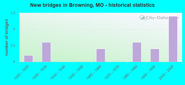
- New bridges - historical statistics
- 11920-1929
- 31930-1939
- 21960-1969
- 31980-1989
- 21990-1999
- 72000-2009


- Bridge Condition - Deck
- 5.9%Excellent
- 41.2%Very good
- 29.4%Good
- 23.5%Satisfactory

- Bridge Condition - Superstructure
- 5.9%Excellent
- 29.4%Very good
- 35.3%Good
- 29.4%Satisfactory

- Bridge Condition - Substructure
- 41.2%Very good
- 41.2%Good
- 5.9%Satisfactory
- 5.9%Fair
- 5.9%Poor

- Bridge Condition - Channel
- 16.7%Good
- 50.0%Satisfactory
- 16.7%Fair
- 16.7%Poor
Find on map >> Show street view
Structure Number: 14062, Location: S 8 T 60 N R 20 W (Lat: 40.034533, Lng: -93.155986), Route carried "on" structure: City street , Year Built: 1989, Status: Open, Structure Length: 1.52m (4.99ft), Average Daily Traffic: 100 (year 2021), Truck Traffic: 10%, Average Future Daily Traffic: 110 (year 2041), Features Intersected: UNNAMED STR, Facility Carried by Structure: D STREET
Minimum Vertical Clearance: 30+ m (98+ ft), Kilometerpoint: 0.161, Lanes on structure: 2, Owner: County Highway Agency, Maintenance Responsibility: City or Municipal Highway Agency, Approaching Roadway Width: 7.0m (23.0ft), Material/Design: Steel, Design/Construction: Stringer/Multi-beam, Number Of Spans In Main Unit: 1, Length of Maximum Span: 14.9m (48.9ft), Curb-To-Curb Width: 6.2m (20.3ft), Out-to-Out Width: 6.2m (20.3ft)
Condition: Deck: Good, Superstructure: Good, Substructure: Good, Channel: Good, Operating Rating: 47.7 metric tons, Method Used To Determine Operating Rating: Allowable Stress (AS), Inventory Rating: 27.0 metric tons, Method Used To Determine Inventory Rating: Allowable Stress (AS), Structural Evaluation: Equal to present minimum criteria, Deck Geometry: Somewhat better than minimum adequacy, Waterway Adequacy: Equal to present desirable criteria, Approach Roadway Alignment: Equal to present desirable criteria, Designated Inspection Frequency: Every 24 months, Inspection Date: November 2020, Deck Structure Type: Concrete Cast-file-Place
Find on map >> Show street view
Structure Number: 14569, Location: S 17 T 60 N R 20 W (Lat: 40.020119, Lng: -93.151178), Route carried "on" structure: County highway 70, Year Built: 1996, Status: Open, Structure Length: 0.76m (2.49ft), Average Daily Traffic: 25 (year 2021), Truck Traffic: 10%, Average Future Daily Traffic: 28 (year 2041), Features Intersected: UNNAMED STR, Facility Carried by Structure: FIELD DR
Minimum Vertical Clearance: 30+ m (98+ ft), Kilometerpoint: 1.770, Lanes on structure: 2, Owner: County Highway Agency, Approaching Roadway Width: 5.5m (18.0ft), Material/Design: Steel, Design/Construction: Stringer/Multi-beam, Number Of Spans In Main Unit: 1, Length of Maximum Span: 7.3m (24.0ft), Curb-To-Curb Width: 6.5m (21.3ft), Out-to-Out Width: 6.6m (21.7ft)
Condition: Deck: Very good, Superstructure: Good, Substructure: Very good, Channel: Satisfactory, Operating Rating: 54.9 metric tons, Method Used To Determine Operating Rating: Load Factor (LF), Inventory Rating: 32.4 metric tons, Method Used To Determine Inventory Rating: Load Factor (LF), Structural Evaluation: Better than present minimum criteria, Deck Geometry: Somewhat better than minimum adequacy, Waterway Adequacy: Better than present minimum criteria, Approach Roadway Alignment: Equal to present desirable criteria, Designated Inspection Frequency: Every 24 months, Inspection Date: November 2020, Deck Structure Type: Concrete Cast-file-Place, Wearing Surface/Protective System: Wearing Surface: Monolithic Concrete
Find on map >> Show street view
Structure Number: 14571, Location: S 17 T 60 N R 20 W (Lat: 40.019553, Lng: -93.151183), Route carried "on" structure: County highway 70, Year Built: 1991, Status: Open, Structure Length: 1.58m (5.18ft), Average Daily Traffic: 25 (year 2021), Truck Traffic: 10%, Average Future Daily Traffic: 28 (year 2041), Design Load: HS 20, Features Intersected: UNNAMED STR, Facility Carried by Structure: FIELD DR
Minimum Vertical Clearance: 30+ m (98+ ft), Kilometerpoint: 1.931, Lanes on structure: 2, Owner: County Highway Agency, Approaching Roadway Width: 7.0m (23.0ft), Material/Design: Steel, Design/Construction: Stringer/Multi-beam, Number Of Spans In Main Unit: 1, Length of Maximum Span: 15.5m (50.9ft), Curb-To-Curb Width: 6.9m (22.6ft), Out-to-Out Width: 7.0m (23.0ft)
Condition: Deck: Good, Superstructure: Good, Substructure: Poor, Channel: Poor, Operating Rating: 59.4 metric tons, Method Used To Determine Operating Rating: Allowable Stress (AS), Inventory Rating: 37.8 metric tons, Method Used To Determine Inventory Rating: Allowable Stress (AS), Structural Evaluation: Meets minimum limits, Deck Geometry: Somewhat better than minimum adequacy, Waterway Adequacy: Better than present minimum criteria, Approach Roadway Alignment: Equal to present desirable criteria, Length Of Structure Improvement: 0.23m (0.75ft), Designated Inspection Frequency: Every 24 months, Inspection Date: November 2020, Bridge Improvement Cost: $113,000, Roadway Improvement Cost: $11,000, Total Project Cost: $170,000 ( Estimate for 2022), Deck Structure Type: Concrete Cast-file-Place, Wearing Surface/Protective System: Wearing Surface: Monolithic Concrete
Find on map >> Show street view
Structure Number: 15222, Location: S 28 T 60 N R 20 W (Lat: 39.993258, Lng: -93.146428), Route carried "on" structure: County highway 88, Year Built: 1988, Status: Open, Structure Length: 0.70m (2.30ft), Average Daily Traffic: 20 (year 2021), Truck Traffic: 10%, Average Future Daily Traffic: 22 (year 2041), Features Intersected: BRANCH, Facility Carried by Structure: FAWN RD
Minimum Vertical Clearance: 30+ m (98+ ft), Kilometerpoint: 2.736, Lanes on structure: 2, Owner: County Highway Agency, Approaching Roadway Width: 5.5m (18.0ft), Material/Design: Steel, Design/Construction: Stringer/Multi-beam, Number Of Spans In Main Unit: 1, Length of Maximum Span: 6.7m (22.0ft), Curb-To-Curb Width: 4.9m (16.1ft), Out-to-Out Width: 4.9m (16.1ft)
Condition: Deck: Good, Superstructure: Satisfactory, Substructure: Good, Channel: Satisfactory, Operating Rating: 57.6 metric tons, Method Used To Determine Operating Rating: Allowable Stress (AS), Inventory Rating: 35.1 metric tons, Method Used To Determine Inventory Rating: Allowable Stress (AS), Structural Evaluation: Equal to present minimum criteria, Deck Geometry: High priority of corrective action, Waterway Adequacy: Equal to present minimum criteria, Approach Roadway Alignment: Equal to present desirable criteria, Designated Inspection Frequency: Every 24 months, Inspection Date: November 2020, Deck Structure Type: Concrete Cast-file-Place
Find on map >> Show street view
Structure Number: 1782, Location: S 7 T 60 N R 20 W (Lat: 40.035553, Lng: -93.172153), Route carried "on" structure: State highway MM, Year Built: 1969, Status: Open, Structure Length: 9.27m (30.41ft), Average Daily Traffic: 328 (year 2021), Truck Traffic: 10%, Average Future Daily Traffic: 410 (year 2041), Design Load: H 15, Features Intersected: LOCUST CR
Minimum Vertical Clearance: 30+ m (98+ ft), Kilometerpoint: 12.749, Lanes on structure: 2, Owner: State Highway Agency, Approaching Roadway Width: 7.3m (24.0ft), Material/Design: Steel continuous, Design/Construction: Stringer/Multi-beam, Number Of Spans In Main Unit: 3, Length of Maximum Span: 36.6m (120.1ft), Curb-To-Curb Width: 10.4m (34.1ft), Out-to-Out Width: 11.2m (36.7ft)
Condition: Deck: Good, Superstructure: Good, Substructure: Good, Channel: Fair, Operating Rating: 36.0 metric tons, Method Used To Determine Operating Rating: Allowable Stress (AS), Inventory Rating: 19.8 metric tons, Method Used To Determine Inventory Rating: Allowable Stress (AS), Structural Evaluation: Somewhat better than minimum adequacy, Deck Geometry: Better than present minimum criteria, Waterway Adequacy: Equal to present desirable criteria, Approach Roadway Alignment: Equal to present desirable criteria, Designated Inspection Frequency: Every 24 months, Inspection Date: September 2020, Deck Structure Type: Concrete Cast-file-Place, Wearing Surface/Protective System: Wearing Surface: Epoxy Overlay
Find on map >> Show street view
Structure Number: 1783, Location: S 11 T 60 N R 21 W (Lat: 40.035406, Lng: -93.220867), Route carried "on" structure: State highway MM, Year Built: 1969, Status: Open, Structure Length: 5.55m (18.21ft), Average Daily Traffic: 221 (year 2021), Truck Traffic: 11%, Average Future Daily Traffic: 276 (year 2041), Design Load: H 15, Features Intersected: W FK LOCUST CR
Minimum Vertical Clearance: 30+ m (98+ ft), Kilometerpoint: 8.607, Lanes on structure: 2, Owner: State Highway Agency, Approaching Roadway Width: 6.7m (22.0ft), Material/Design: Steel continuous, Design/Construction: Stringer/Multi-beam, Number Of Spans In Main Unit: 3, Length of Maximum Span: 21.6m (70.9ft), Curb-To-Curb Width: 8.5m (27.9ft), Out-to-Out Width: 9.4m (30.8ft)
Condition: Deck: Satisfactory, Superstructure: Good, Substructure: Good, Channel: Poor, Operating Rating: 36.0 metric tons, Method Used To Determine Operating Rating: Allowable Stress (AS), Inventory Rating: 21.6 metric tons, Method Used To Determine Inventory Rating: Allowable Stress (AS), Structural Evaluation: Equal to present minimum criteria, Deck Geometry: Equal to present minimum criteria, Waterway Adequacy: Equal to present desirable criteria, Approach Roadway Alignment: Equal to present desirable criteria, Designated Inspection Frequency: Every 24 months, Inspection Date: August 2021, Deck Structure Type: Concrete Cast-file-Place, Wearing Surface/Protective System: Wearing Surface: Epoxy Overlay
Find on map >> Show street view
Structure Number: 29389, Location: S 7 T 60 N R 20 W (Lat: 40.029000, Lng: -93.182531), Route carried "on" structure: County highway 69, Year Built: 2001, Status: Open, Structure Length: 1.24m (4.07ft), Average Daily Traffic: 20 (year 2021), Truck Traffic: 10%, Average Future Daily Traffic: 22 (year 2041), Features Intersected: BR OF LOCUST CR, Facility Carried by Structure: ELK RD
Minimum Vertical Clearance: 30+ m (98+ ft), Kilometerpoint: 0.966, Lanes on structure: 2, Owner: County Highway Agency, Approaching Roadway Width: 4.9m (16.1ft), Material/Design: Steel, Design/Construction: Stringer/Multi-beam, Number Of Spans In Main Unit: 1, Length of Maximum Span: 12.0m (39.4ft), Curb-To-Curb Width: 6.2m (20.3ft), Out-to-Out Width: 6.5m (21.3ft)
Condition: Deck: Very good, Superstructure: Very good, Substructure: Very good, Channel: Fair, Operating Rating: 72.0 metric tons, Method Used To Determine Operating Rating: Load Factor (LF), Inventory Rating: 43.2 metric tons, Method Used To Determine Inventory Rating: Load Factor (LF), Structural Evaluation: Equal to present desirable criteria, Deck Geometry: Somewhat better than minimum adequacy, Waterway Adequacy: Equal to present desirable criteria, Approach Roadway Alignment: Equal to present desirable criteria, Designated Inspection Frequency: Every 24 months, Inspection Date: December 2020, Deck Structure Type: Concrete Cast-file-Place, Wearing Surface/Protective System: Wearing Surface: Monolithic Concrete
Find on map >> Show street view
Structure Number: 29394, Location: S 20 T 60 N R 20 W (Lat: 40.014675, Lng: -93.161636), Route carried "on" structure: County highway 70, Year Built: 2002, Status: Open, Structure Length: 1.23m (4.04ft), Average Daily Traffic: 15 (year 2021), Truck Traffic: 10%, Average Future Daily Traffic: 17 (year 2041), Features Intersected: BR OF LOCUST CR, Facility Carried by Structure: FROST RD
Minimum Vertical Clearance: 30+ m (98+ ft), Kilometerpoint: 3.219, Lanes on structure: 2, Owner: County Highway Agency, Approaching Roadway Width: 5.5m (18.0ft), Material/Design: Steel, Design/Construction: Stringer/Multi-beam, Number Of Spans In Main Unit: 1, Length of Maximum Span: 12.0m (39.4ft), Curb-To-Curb Width: 6.2m (20.3ft), Out-to-Out Width: 6.5m (21.3ft)
Condition: Deck: Very good, Superstructure: Very good, Substructure: Very good, Channel: Good, Inventory Rating: 65.7 metric tons, Method Used To Determine Inventory Rating: Load Factor (LF), Structural Evaluation: Equal to present desirable criteria, Deck Geometry: Somewhat better than minimum adequacy, Waterway Adequacy: Equal to present minimum criteria, Approach Roadway Alignment: Equal to present desirable criteria, Designated Inspection Frequency: Every 24 months, Inspection Date: November 2020, Deck Structure Type: Concrete Cast-file-Place, Wearing Surface/Protective System: Wearing Surface: Monolithic Concrete
Find on map >> Show street view
Structure Number: 29514, Location: S 34 T 61 N R 20 W (Lat: 40.044058, Lng: -93.130706), Route carried "on" structure: County highway 399, Year Built: 2001, Status: Open, Structure Length: 1.52m (4.99ft), Average Daily Traffic: 15 (year 2021), Truck Traffic: 10%, Average Future Daily Traffic: 17 (year 2041), Features Intersected: UNNAMED STREAM, Facility Carried by Structure: WOODLAND RD
Minimum Vertical Clearance: 30+ m (98+ ft), Kilometerpoint: 1.127, Lanes on structure: 2, Owner: County Highway Agency, Approaching Roadway Width: 5.5m (18.0ft), Material/Design: Steel, Design/Construction: Stringer/Multi-beam, Number Of Spans In Main Unit: 1, Length of Maximum Span: 15.0m (49.2ft), Curb-To-Curb Width: 5.9m (19.4ft), Out-to-Out Width: 6.1m (20.0ft)
Condition: Deck: Very good, Superstructure: Very good, Substructure: Very good, Channel: Satisfactory, Operating Rating: 29.7 metric tons, Method Used To Determine Operating Rating: Load Factor (LF), Inventory Rating: 18.0 metric tons, Method Used To Determine Inventory Rating: Load Factor (LF), Structural Evaluation: Somewhat better than minimum adequacy, Deck Geometry: Meets minimum limits, Waterway Adequacy: Equal to present minimum criteria, Approach Roadway Alignment: High priority of corrective action, Length Of Structure Improvement: 0.22m (0.72ft), Designated Inspection Frequency: Every 24 months, Inspection Date: December 2021, Bridge Improvement Cost: $109,000, Roadway Improvement Cost: $11,000, Total Project Cost: $163,000 ( Estimate for 2022), Deck Structure Type: Concrete Cast-file-Place, Wearing Surface/Protective System: Wearing Surface: Monolithic Concrete
Find on map >> Show street view
Structure Number: 31829, Location: S 27 T 61 N R 20 W (Lat: 40.065272, Lng: -93.129150), Route carried "on" structure: County highway 409, Year Built: 2006, Status: Open, Structure Length: 3.38m (11.09ft), Average Daily Traffic: 15 (year 2021), Truck Traffic: 10%, Average Future Daily Traffic: 17 (year 2041), Features Intersected: TRIB LIT E LOCUST, Facility Carried by Structure: DENVER DR
Minimum Vertical Clearance: 30+ m (98+ ft), Kilometerpoint: 0.000, Lanes on structure: 2, Owner: County Highway Agency, Approaching Roadway Width: 6.1m (20.0ft), Material/Design: Steel continuous, Design/Construction: Stringer/Multi-beam, Number Of Spans In Main Unit: 3, Length of Maximum Span: 10.7m (35.1ft), Curb-To-Curb Width: 6.1m (20.0ft), Out-to-Out Width: 6.4m (21.0ft)
Condition: Deck: Very good, Superstructure: Satisfactory, Substructure: Very good, Channel: Satisfactory, Inventory Rating: 63.9 metric tons, Method Used To Determine Inventory Rating: Load Factor (LF), Structural Evaluation: Equal to present minimum criteria, Deck Geometry: Somewhat better than minimum adequacy, Waterway Adequacy: Better than present minimum criteria, Approach Roadway Alignment: Equal to present minimum criteria, Designated Inspection Frequency: Every 24 months, Inspection Date: December 2021, Deck Structure Type: Concrete Cast-file-Place
Find on map >> Show street view
Structure Number: 3183, Location: S 20 T 61 N R 20 W (Lat: 40.056581, Lng: -93.147756), Route carried "on" structure: County highway 424, Year Built: 2006, Status: Open, Structure Length: 1.10m (3.61ft), Average Daily Traffic: 35 (year 2021), Truck Traffic: 10%, Average Future Daily Traffic: 39 (year 2041), Features Intersected: TRIB E FK LOCUST C, Facility Carried by Structure: DENVER DR
Minimum Vertical Clearance: 30+ m (98+ ft), Kilometerpoint: 0.000, Lanes on structure: 2, Owner: County Highway Agency, Approaching Roadway Width: 6.1m (20.0ft), Material/Design: Steel, Design/Construction: Stringer/Multi-beam, Number Of Spans In Main Unit: 1, Length of Maximum Span: 10.7m (35.1ft), Curb-To-Curb Width: 6.1m (20.0ft), Out-to-Out Width: 6.4m (21.0ft)
Condition: Deck: Very good, Superstructure: Good, Substructure: Very good, Channel: Good, Operating Rating: 89.1 metric tons, Method Used To Determine Operating Rating: Load Factor (LF), Inventory Rating: 54.0 metric tons, Method Used To Determine Inventory Rating: Load Factor (LF), Structural Evaluation: Better than present minimum criteria, Deck Geometry: Somewhat better than minimum adequacy, Waterway Adequacy: Better than present minimum criteria, Approach Roadway Alignment: Equal to present desirable criteria, Designated Inspection Frequency: Every 24 months, Inspection Date: December 2021, Deck Structure Type: Concrete Cast-file-Place
Find on map >> Show street view
Structure Number: 32295, Location: S 23 T 60 N R 20 W (Lat: 40.016214, Lng: -93.095694), Route carried "on" structure: County highway 101, Year Built: 2007, Status: Open, Structure Length: 0.91m (2.99ft), Average Daily Traffic: 15 (year 2021), Truck Traffic: 10%, Average Future Daily Traffic: 17 (year 2041), Features Intersected: BR OF LONG BR, Facility Carried by Structure: HATCH RD
Minimum Vertical Clearance: 30+ m (98+ ft), Kilometerpoint: 0.000, Lanes on structure: 2, Owner: County Highway Agency, Approaching Roadway Width: 5.5m (18.0ft), Material/Design: Steel, Design/Construction: Stringer/Multi-beam, Number Of Spans In Main Unit: 1, Length of Maximum Span: 8.5m (27.9ft), Curb-To-Curb Width: 6.1m (20.0ft), Out-to-Out Width: 6.7m (22.0ft)
Condition: Deck: Very good, Superstructure: Excellent, Substructure: Very good, Channel: Satisfactory, Inventory Rating: 88.2 metric tons, Method Used To Determine Inventory Rating: Load Factor (LF), Structural Evaluation: Equal to present desirable criteria, Deck Geometry: Somewhat better than minimum adequacy, Waterway Adequacy: Better than present minimum criteria, Approach Roadway Alignment: Equal to present desirable criteria, Designated Inspection Frequency: Every 24 months, Inspection Date: November 2020, Deck Structure Type: Concrete Cast-file-Place
Find on map >> Show street view
Structure Number: 32419, Location: S 22 T 61 N R 20 W (Lat: 40.065619, Lng: -93.140175), Route carried "on" structure: County highway 424, Year Built: 2008, Status: Open, Structure Length: 3.87m (12.70ft), Average Daily Traffic: 40 (year 2021), Truck Traffic: 25%, Average Future Daily Traffic: 44 (year 2041), Design Load: HS 20, Features Intersected: E FK OF LOCUST CR
Minimum Vertical Clearance: 30+ m (98+ ft), Kilometerpoint: 0.000, Lanes on structure: 2, Owner: County Highway Agency, Approaching Roadway Width: 6.1m (20.0ft), Skew: 1 degrees, Material/Design: Concrete continuous, Design/Construction: Channel Beam, Number Of Spans In Main Unit: 3, Length of Maximum Span: 12.8m (42.0ft), Curb-To-Curb Width: 6.8m (22.3ft), Out-to-Out Width: 6.9m (22.6ft)
Condition: Deck: Excellent, Superstructure: Very good, Substructure: Good, Channel: Satisfactory, Operating Rating: 54.0 metric tons, Method Used To Determine Operating Rating: Load Factor (LF), Inventory Rating: 32.4 metric tons, Method Used To Determine Inventory Rating: Load Factor (LF), Structural Evaluation: Better than present minimum criteria, Deck Geometry: Somewhat better than minimum adequacy, Waterway Adequacy: Equal to present minimum criteria, Approach Roadway Alignment: Equal to present minimum criteria, Designated Inspection Frequency: Every 24 months, Inspection Date: December 2021, Deck Structure Type: Concrete Precast Panels, Wearing Surface/Protective System: Wearing Surface: Monolithic Concrete
Find on map >> Show street view
Structure Number: 3611, Location: S 28 T 61 N R 20 W (Lat: 40.056917, Lng: -93.158967), Route carried "on" structure: State highway 5, Year Built: 1985, Status: Open, Structure Length: 7.74m (25.39ft), Average Daily Traffic: 1,119 (year 2021), Truck Traffic: 24%, Average Future Daily Traffic: 1,455 (year 2041), Design Load: HS 20, Features Intersected: E FK LOCUST CR
Minimum Vertical Clearance: 30+ m (98+ ft), Kilometerpoint: 67.451, Lanes on structure: 2, Base Highway Network: Yes, Owner: State Highway Agency, Approaching Roadway Width: 11.6m (38.1ft), Skew: 4 degrees, Material/Design: Prestressed concrete continuous, Design/Construction: Stringer/Multi-beam, Number Of Spans In Main Unit: 3, Length of Maximum Span: 25.9m (85.0ft), Curb or Sidewalk Widths: Left: 0.2m (0.7ft), Right: 0.2m (0.7ft), Curb-To-Curb Width: 11.2m (36.7ft), Out-to-Out Width: 11.9m (39.0ft)
Condition: Deck: Good, Superstructure: Very good, Substructure: Good, Channel: Satisfactory, Operating Rating: 77.4 metric tons, Method Used To Determine Operating Rating: Load Factor (LF), Inventory Rating: 40.5 metric tons, Method Used To Determine Inventory Rating: Load Factor (LF), Structural Evaluation: Better than present minimum criteria, Deck Geometry: Equal to present minimum criteria, Waterway Adequacy: Equal to present desirable criteria, Approach Roadway Alignment: Equal to present desirable criteria, Designated Inspection Frequency: Every 24 months, Inspection Date: August 2021, Deck Structure Type: Concrete Cast-file-Place, Wearing Surface/Protective System: Wearing Surface: Monolithic Concrete, Deck Protection: Epoxy Coated Reinforcing
Find on map >> Show street view
Structure Number: 5249, Location: S 17 T 60 N R 20 W (Lat: 40.018422, Lng: -93.170447), Route carried "on" structure: State highway 5, Year Built: 1930, Year Reconstructed: 1977, Status: Open, Structure Length: 2.04m (6.69ft), Average Daily Traffic: 934 (year 2021), Truck Traffic: 14%, Average Future Daily Traffic: 1,214 (year 2041), Design Load: H 20, Features Intersected: BR OF LOCUST CR
Minimum Vertical Clearance: 30+ m (98+ ft), Kilometerpoint: 71.935, Lanes on structure: 2, Base Highway Network: Yes, Owner: State Highway Agency, Approaching Roadway Width: 7.3m (24.0ft), Material/Design: Concrete, Design/Construction: Slab, Number Of Spans In Main Unit: 3, Length of Maximum Span: 6.7m (22.0ft), Curb-To-Curb Width: 8.5m (27.9ft), Out-to-Out Width: 9.4m (30.8ft)
Condition: Deck: Satisfactory, Superstructure: Satisfactory, Substructure: Good, Channel: Satisfactory, Operating Rating: 45.0 metric tons, Method Used To Determine Operating Rating: Load Factor (LF), Inventory Rating: 27.0 metric tons, Method Used To Determine Inventory Rating: Load Factor (LF), Structural Evaluation: Equal to present minimum criteria, Deck Geometry: Somewhat better than minimum adequacy, Waterway Adequacy: Equal to present desirable criteria, Approach Roadway Alignment: Equal to present desirable criteria, Designated Inspection Frequency: Every 24 months, Inspection Date: September 2020, Deck Structure Type: Concrete Cast-file-Place, Wearing Surface/Protective System: Wearing Surface: Bituminous, Membrane: Built-up
Find on map >> Show street view
Structure Number: 525, Location: S 17 T 60 N R 20 W (Lat: 40.025578, Lng: -93.166836), Route carried "on" structure: State highway 5, Year Built: 1930, Year Reconstructed: 1977, Status: Open, Structure Length: 3.99m (13.09ft), Average Daily Traffic: 934 (year 2021), Truck Traffic: 14%, Average Future Daily Traffic: 1,214 (year 2041), Design Load: H 20, Features Intersected: BR OF LOCUST CR
Minimum Vertical Clearance: 30+ m (98+ ft), Kilometerpoint: 71.074, Lanes on structure: 2, Base Highway Network: Yes, Owner: State Highway Agency, Approaching Roadway Width: 7.3m (24.0ft), Skew: 3 degrees, Material/Design: Concrete, Design/Construction: Tee Beam, Number Of Spans In Main Unit: 5, Length of Maximum Span: 8.1m (26.6ft), Curb-To-Curb Width: 8.5m (27.9ft), Out-to-Out Width: 9.4m (30.8ft)
Condition: Deck: Satisfactory, Superstructure: Satisfactory, Substructure: Fair, Channel: Poor, Operating Rating: 61.2 metric tons, Method Used To Determine Operating Rating: Load Factor (LF), Inventory Rating: 36.9 metric tons, Method Used To Determine Inventory Rating: Load Factor (LF), Structural Evaluation: Somewhat better than minimum adequacy, Deck Geometry: Somewhat better than minimum adequacy, Waterway Adequacy: Equal to present desirable criteria, Approach Roadway Alignment: Equal to present desirable criteria, Designated Inspection Frequency: Every 24 months, Inspection Date: September 2020, Deck Structure Type: Concrete Cast-file-Place, Wearing Surface/Protective System: Wearing Surface: Bituminous, Membrane: Built-up
Find on map >> Show street view
Structure Number: 5291, Location: S 19 T 60 N R 20 W (Lat: 40.004792, Lng: -93.177322), Route carried "on" structure: State highway 5, Year Built: 1929, Year Reconstructed: 1977, Status: Open, Structure Length: 1.31m (4.30ft), Average Daily Traffic: 934 (year 2021), Truck Traffic: 14%, Average Future Daily Traffic: 1,214 (year 2041), Design Load: H 20, Features Intersected: BR OF LOCUST CR
Minimum Vertical Clearance: 30+ m (98+ ft), Kilometerpoint: 73.562, Lanes on structure: 2, Base Highway Network: Yes, Owner: State Highway Agency, Approaching Roadway Width: 7.3m (24.0ft), Material/Design: Concrete, Design/Construction: Slab, Number Of Spans In Main Unit: 3, Length of Maximum Span: 4.3m (14.1ft), Curb-To-Curb Width: 8.5m (27.9ft), Out-to-Out Width: 9.4m (30.8ft)
Condition: Deck: Satisfactory, Superstructure: Satisfactory, Substructure: Satisfactory, Channel: Satisfactory, Operating Rating: 32.4 metric tons, Method Used To Determine Operating Rating: Allowable Stress (AS), Inventory Rating: 21.6 metric tons, Method Used To Determine Inventory Rating: Allowable Stress (AS), Structural Evaluation: Somewhat better than minimum adequacy, Deck Geometry: Somewhat better than minimum adequacy, Waterway Adequacy: Equal to present desirable criteria, Approach Roadway Alignment: Equal to present desirable criteria, Designated Inspection Frequency: Every 24 months, Inspection Date: September 2020, Deck Structure Type: Concrete Cast-file-Place, Wearing Surface/Protective System: Wearing Surface: Bituminous, Membrane: Built-up
Find on map >> Show street view
Structure Number: 8756, Location: S 30 T 37 N R 32 W (Lat: 37.956122, Lng: -94.499603), Route carried "on" structure: State highway D, Year Built: 1937, Status: Open, Structure Length: 1.04m (3.41ft), Average Daily Traffic: 106 (year 2021), Truck Traffic: 10%, Average Future Daily Traffic: 148 (year 2041), Design Load: H 10, Features Intersected: DRY BR
Minimum Vertical Clearance: 30+ m (98+ ft), Kilometerpoint: 11.602, Lanes on structure: 2, Owner: State Highway Agency, Approaching Roadway Width: 7.3m (24.0ft), Skew: 4 degrees, Material/Design: Concrete continuous, Design/Construction: Culvert, Number Of Spans In Main Unit: 2, Length of Maximum Span: 3.7m (12.1ft)
Condition: Channel: Fair, Culverts: Satisfactory, Operating Rating: 53.1 metric tons, Method Used To Determine Operating Rating: Load Factor (LF), Inventory Rating: 31.5 metric tons, Method Used To Determine Inventory Rating: Load Factor (LF), Structural Evaluation: Equal to present minimum criteria, Waterway Adequacy: Equal to present minimum criteria, Approach Roadway Alignment: Equal to present desirable criteria, Designated Inspection Frequency: Every 24 months, Inspection Date: March 2022