Bridge Statistics for Brownstown, Pennsylvania (PA)
Condition, Traffic, Stress, Structural Evaluation, Project Costs
- National Bridge Inventory (NBI) Statistics
- 22Number of bridges
- 364ft / 111mTotal length
- $17,755,000Total costs
- 281,265Total average daily traffic
- 68,878Total average daily truck traffic
- National Bridge Inventory (NBI) Registered Bridges for Brownstown
- No street view available for this location
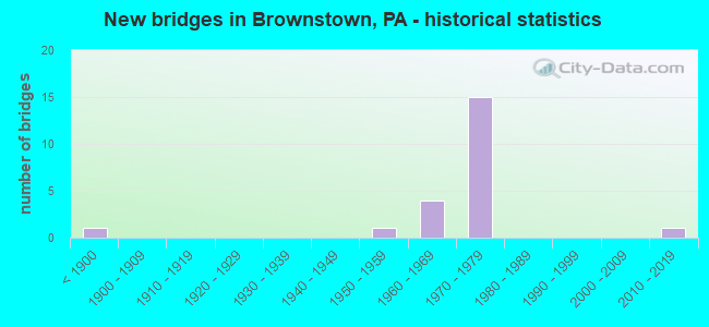
- New bridges - historical statistics
- 1Before 1900
- 11950-1959
- 41960-1969
- 151970-1979
- 12010-2019
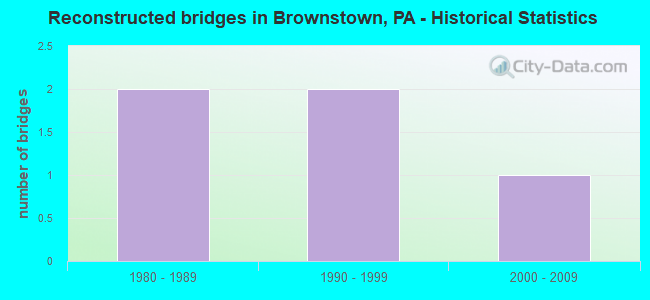
- Reconstructed bridges - Historical Statistics
- 21980-1989
- 21990-1999
- 12000-2009

- Bridge Condition - Deck
- 54.5%Good
- 27.3%Satisfactory
- 18.2%Fair
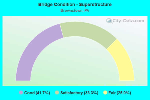
- Bridge Condition - Superstructure
- 41.7%Good
- 33.3%Satisfactory
- 25.0%Fair
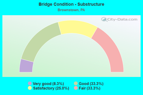
- Bridge Condition - Substructure
- 8.3%Very good
- 33.3%Good
- 25.0%Satisfactory
- 33.3%Fair
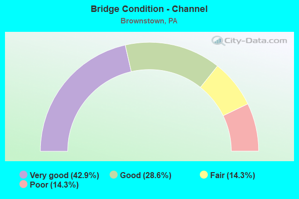
- Bridge Condition - Channel
- 42.9%Very good
- 28.6%Good
- 14.3%Fair
- 14.3%Poor
Find on map >> Show street view
Structure Number: 9288, Location: CLFD & CENTRE CNTY LINE (Lat: 40.968114, Lng: -78.085053), Route carried "on" structure: Interstate 80, Year Built: 1968, Year Reconstructed: 2004, Status: Open, Structure Length: 43.07m (141.31ft), Average Daily Traffic: 9,471 (year 2021), Truck Traffic: 91%, Average Future Daily Traffic: 12,839 (year 2041), Design Load: HL 93, Features Intersected: MOSHANNON CREEK
Minimum Vertical Clearance: 30+ m (98+ ft), Kilometerpoint: 0.000, Lanes on structure: 2, Base Highway Network: Yes, Owner: State Highway Agency, Approaching Roadway Width: 11.6m (38.1ft), Skew: 10 degrees, Material/Design: Steel continuous, Design/Construction: Stringer/Multi-beam, Number Of Spans In Main Unit: 8, Length of Maximum Span: 56.1m (184.1ft), Curb or Sidewalk Widths: Left: 0.1m (0.3ft), Right: 0.1m (0.3ft), Curb-To-Curb Width: 12.8m (42.0ft), Out-to-Out Width: 13.7m (44.9ft)
Condition: Deck: Satisfactory, Superstructure: Good, Substructure: Good, Channel: Very good, Operating Rating: 81.6 metric tons, Method Used To Determine Operating Rating: Load Factor (LF), Inventory Rating: 49.0 metric tons, Method Used To Determine Inventory Rating: Load Factor (LF), Structural Evaluation: Better than present minimum criteria, Deck Geometry: Equal to present desirable criteria, Waterway Adequacy: Superior to present desirable criteria, Approach Roadway Alignment: Equal to present desirable criteria, Length Of Structure Improvement: 43.10m (141.40ft), Designated Inspection Frequency: Every 24 months, Inspection Date: May 2021, Bridge Improvement Cost: $1,016,000, Roadway Improvement Cost: $2,991,000, Total Project Cost: $13,710,000, Deck Structure Type: Concrete Cast-file-Place, Wearing Surface/Protective System: Wearing Surface: Monolithic Concrete, Deck Protection: Epoxy Coated Reinforcing
Find on map >> Show street view
Structure Number: 9289, Location: 6 MI W EXIT 147 (Lat: 40.986789, Lng: -78.031292), Route carried "on" structure: Interstate 80, Year Built: 1966, Year Reconstructed: 1991, Status: Open, Structure Length: 6.80m (22.31ft), Average Daily Traffic: 10,340 (year 2021), Truck Traffic: 88%, Average Future Daily Traffic: 12,999 (year 2041), Design Load: HS 20, Features Intersected: FORESTRY RD;BLACK MOSH C
Minimum Vertical Clearance: 30+ m (98+ ft), Kilometerpoint: 4.785, Lanes on structure: 2, Lanes under structure: 2, Base Highway Network: Yes, Owner: State Highway Agency, Approaching Roadway Width: 11.6m (38.1ft), Skew: 14 degrees, Material/Design: Prestressed concrete continuous, Design/Construction: Box Beam or Girders - Single/Spread, Number Of Spans In Main Unit: 3, Length of Maximum Span: 22.9m (75.1ft), Curb or Sidewalk Widths: Left: 0.2m (0.7ft), Right: 0.2m (0.7ft), Curb-To-Curb Width: 12.3m (40.4ft), Out-to-Out Width: 13.3m (43.6ft)
Condition: Deck: Satisfactory, Superstructure: Good, Substructure: Good, Channel: Very good, Operating Rating: 96.2 metric tons, Method Used To Determine Operating Rating: Load Factor (LF), Inventory Rating: 45.4 metric tons, Method Used To Determine Inventory Rating: Load Factor (LF), Structural Evaluation: Better than present minimum criteria, Deck Geometry: Better than present minimum criteria, Underclear: High priority of corrective action, Waterway Adequacy: Superior to present desirable criteria, Approach Roadway Alignment: Better than present minimum criteria, Length Of Structure Improvement: 6.80m (22.31ft), Designated Inspection Frequency: Every 24 months, Inspection Date: May 2021, Deck Structure Type: Concrete Cast-file-Place, Wearing Surface/Protective System: Wearing Surface: Monolithic Concrete, Deck Protection: Epoxy Coated Reinforcing
Find on map >> Show street view
Structure Number: 929, Location: 6 MI W EXIT 147 (Lat: 40.987400, Lng: -78.031392), Route carried "on" structure: Interstate 80, Year Built: 1967, Year Reconstructed: 1991, Status: Open, Structure Length: 6.83m (22.41ft), Average Daily Traffic: 9,471 (year 2021), Truck Traffic: 91%, Average Future Daily Traffic: 12,839 (year 2041), Design Load: HS 20, Features Intersected: FORESTRY RD;BLACK MOSH C
Minimum Vertical Clearance: 30+ m (98+ ft), Kilometerpoint: 4.767, Lanes on structure: 2, Lanes under structure: 2, Base Highway Network: Yes, Owner: State Highway Agency, Approaching Roadway Width: 11.6m (38.1ft), Skew: 15 degrees, Material/Design: Prestressed concrete continuous, Design/Construction: Box Beam or Girders - Single/Spread, Number Of Spans In Main Unit: 3, Length of Maximum Span: 22.9m (75.1ft), Curb or Sidewalk Widths: Left: 0.2m (0.7ft), Right: 0.2m (0.7ft), Curb-To-Curb Width: 12.2m (40.0ft), Out-to-Out Width: 13.3m (43.6ft)
Condition: Deck: Good, Superstructure: Good, Substructure: Good, Channel: Very good, Operating Rating: 99.8 metric tons, Method Used To Determine Operating Rating: Load Factor (LF), Inventory Rating: 45.4 metric tons, Method Used To Determine Inventory Rating: Load Factor (LF), Structural Evaluation: Better than present minimum criteria, Deck Geometry: Better than present minimum criteria, Underclear: High priority of corrective action, Waterway Adequacy: Superior to present desirable criteria, Approach Roadway Alignment: Better than present minimum criteria, Length Of Structure Improvement: 6.80m (22.31ft), Designated Inspection Frequency: Every 24 months, Inspection Date: May 2021, Deck Structure Type: Concrete Cast-file-Place, Wearing Surface/Protective System: Wearing Surface: Monolithic Concrete, Deck Protection: Epoxy Coated Reinforcing
Find on map >> Show street view
Structure Number: 9294, Location: SNOW SHOE (Lat: 41.022386, Lng: -77.904189), Route carried "on" structure: Interstate 80, Year Built: 1966, Status: Open, Structure Length: 0.98m (3.22ft), Average Daily Traffic: 28,541 (year 2020), Truck Traffic: 41%, Average Future Daily Traffic: 28,137 (year 2041), Design Load: HS 20, Features Intersected: SOUTH FORK BEECH CREEK
Minimum Vertical Clearance: 30+ m (98+ ft), Kilometerpoint: 16.897, Lanes on structure: 4, Base Highway Network: Yes, Owner: State Highway Agency, Approaching Roadway Width: 11.6m (38.1ft), Skew: 21 degrees, Material/Design: Concrete, Design/Construction: Culvert, Number Of Spans In Main Unit: 1, Length of Maximum Span: 9.8m (32.2ft)
Condition: Channel: Fair, Culverts: Good, Inventory Rating: 99.8 metric tons, Method Used To Determine Inventory Rating: Field evaluation and documented engineering judgment, Structural Evaluation: Better than present minimum criteria, Waterway Adequacy: Superior to present desirable criteria, Approach Roadway Alignment: Equal to present desirable criteria, Length Of Structure Improvement: 1.00m (3.28ft), Designated Inspection Frequency: Every 24 months, Inspection Date: April 2021
Find on map >> Show street view
Structure Number: 1542, Location: HAVERFORD TWP. 3477K9 (Lat: 40.011056, Lng: -75.316144), Route carried "on" structure: City street , Year Built: 1973, Status: Open, Structure Length: 2.01m (6.59ft), Average Daily Traffic: 2,000 (year 1992), Truck Traffic: 2%, Average Future Daily Traffic: 2,800 (year 2015), Features Intersected: SEPTA TROLLEY, Facility Carried by Structure: BUCK LANE
Minimum Vertical Clearance: 30+ m (98+ ft), Kilometerpoint: 0.000, Lanes on structure: 2, Owner: Town or Township Highway Agency, Approaching Roadway Width: 7.3m (24.0ft), Material/Design: Prestressed concrete, Design/Construction: Box Beam or Girders - Multiple, Number Of Spans In Main Unit: 1, Length of Maximum Span: 19.5m (64.0ft), Curb or Sidewalk Widths: Left: 0.3m (1.0ft), Right: 1.5m (4.9ft), Curb-To-Curb Width: 7.3m (24.0ft), Out-to-Out Width: 10.0m (32.8ft)
Condition: Deck: Fair, Superstructure: Satisfactory, Substructure: Satisfactory, Operating Rating: 62.6 metric tons, Method Used To Determine Operating Rating: Field evaluation and documented engineering judgment, Inventory Rating: 37.2 metric tons, Method Used To Determine Inventory Rating: Field evaluation and documented engineering judgment, Structural Evaluation: Equal to present minimum criteria, Deck Geometry: Meets minimum limits, Underclear: High priority of corrective action, Approach Roadway Alignment: Equal to present desirable criteria, Length Of Structure Improvement: 2.30m (7.55ft), Designated Inspection Frequency: Every 24 months, Inspection Date: Febuary 2021, Bridge Improvement Cost: $31,000, Roadway Improvement Cost: $92,000, Total Project Cost: $421,000, Wearing Surface/Protective System: Wearing Surface: Bituminous
Find on map >> Show street view
Structure Number: 2109, Location: 0.5 MI.S. OF PA 772 (Lat: 40.120628, Lng: -76.224422), Route carried "on" structure: State highway , Year Built: 1972, Status: Open, Structure Length: 10.79m (35.40ft), Average Daily Traffic: 820 (year 2022), Truck Traffic: 5%, Average Future Daily Traffic: 1,391 (year 2032), Design Load: HS 20, Features Intersected: US 222 at 0820 2646, Facility Carried by Structure: 1070 Stone Quarry
Minimum Vertical Clearance: 30+ m (98+ ft), Kilometerpoint: 0.000, Lanes on structure: 2, Lanes under structure: 4, Owner: State Highway Agency, Approaching Roadway Width: 9.1m (29.9ft), Skew: 4 degrees, Material/Design: Steel continuous, Design/Construction: Stringer/Multi-beam, Number Of Spans In Main Unit: 2, Number Of Approach Spans: 2, Length of Maximum Span: 39.0m (128.0ft), Curb or Sidewalk Widths: Left: 0.2m (0.7ft), Right: 0.2m (0.7ft), Curb-To-Curb Width: 12.8m (42.0ft), Out-to-Out Width: 14.0m (45.9ft)
Condition: Deck: Good, Superstructure: Satisfactory, Substructure: Satisfactory, Operating Rating: 53.5 metric tons, Method Used To Determine Operating Rating: Load Factor (LF), Inventory Rating: 31.8 metric tons, Method Used To Determine Inventory Rating: Load Factor (LF), Structural Evaluation: Equal to present minimum criteria, Deck Geometry: Superior to present desirable criteria, Underclear: High priority of corrective action, Approach Roadway Alignment: Equal to present desirable criteria, Length Of Structure Improvement: 11.60m (38.06ft), Designated Inspection Frequency: Every 24 months, Inspection Date: August 2020, Bridge Improvement Cost: $119,000, Roadway Improvement Cost: $350,000, Total Project Cost: $1,604,000, Deck Structure Type: Concrete Cast-file-Place, Wearing Surface/Protective System: Wearing Surface: Latex Concrete
Find on map >> Show street view
Structure Number: 21092, Location: PA 772 AT BROWNSTOWN (Lat: 40.129164, Lng: -76.216064), Route carried "on" structure: US 222, Year Built: 1972, Status: Open, Structure Length: 6.34m (20.80ft), Average Daily Traffic: 26,574 (year 2020), Truck Traffic: 15%, Average Future Daily Traffic: 32,900 (year 2032), Design Load: HS 20, Features Intersected: PA 772; SR 0772
Minimum Vertical Clearance: 30+ m (98+ ft), Kilometerpoint: 58.467, Lanes on structure: 3, Lanes under structure: 6, Base Highway Network: Yes, Owner: State Highway Agency, Approaching Roadway Width: 15.2m (49.9ft), Skew: 13 degrees, Material/Design: Steel, Design/Construction: Stringer/Multi-beam, Number Of Spans In Main Unit: 1, Number Of Approach Spans: 2, Length of Maximum Span: 36.9m (121.1ft), Curb or Sidewalk Widths: Left: 0.2m (0.7ft), Right: 0.2m (0.7ft), Curb-To-Curb Width: 15.6m (51.2ft), Out-to-Out Width: 16.8m (55.1ft)
Condition: Deck: Good, Superstructure: Fair, Substructure: Fair, Operating Rating: 58.1 metric tons, Method Used To Determine Operating Rating: Load Factor (LF), Inventory Rating: 34.5 metric tons, Method Used To Determine Inventory Rating: Load Factor (LF), Structural Evaluation: Somewhat better than minimum adequacy, Deck Geometry: Somewhat better than minimum adequacy, Underclear: Meets minimum limits, Approach Roadway Alignment: Equal to present desirable criteria, Length Of Structure Improvement: 7.30m (23.95ft), Designated Inspection Frequency: Every 24 months, Inspection Date: August 2020, Bridge Improvement Cost: $17,000, Roadway Improvement Cost: $50,000, Total Project Cost: $231,000, Deck Structure Type: Concrete Cast-file-Place, Wearing Surface/Protective System: Wearing Surface: Latex Concrete
Find on map >> Show street view
Structure Number: 21094, Location: BROWNSTOWN (Lat: 40.128667, Lng: -76.217044), Route carried "on" structure: US 222, Year Built: 1972, Status: Open, Structure Length: 6.34m (20.80ft), Average Daily Traffic: 23,601 (year 2020), Truck Traffic: 14%, Average Future Daily Traffic: 28,240 (year 2032), Design Load: HS 20, Features Intersected: PA 772; SR 0772
Minimum Vertical Clearance: 30+ m (98+ ft), Kilometerpoint: 58.492, Lanes on structure: 2, Lanes under structure: 6, Base Highway Network: Yes, Owner: State Highway Agency, Approaching Roadway Width: 11.6m (38.1ft), Skew: 13 degrees, Material/Design: Steel, Design/Construction: Stringer/Multi-beam, Number Of Spans In Main Unit: 1, Number Of Approach Spans: 2, Length of Maximum Span: 36.9m (121.1ft), Curb or Sidewalk Widths: Left: 0.2m (0.7ft), Right: 0.2m (0.7ft), Curb-To-Curb Width: 11.9m (39.0ft), Out-to-Out Width: 13.2m (43.3ft)
Condition: Deck: Good, Superstructure: Fair, Substructure: Fair, Operating Rating: 54.4 metric tons, Method Used To Determine Operating Rating: Load Factor (LF), Inventory Rating: 32.7 metric tons, Method Used To Determine Inventory Rating: Load Factor (LF), Structural Evaluation: Somewhat better than minimum adequacy, Deck Geometry: Equal to present minimum criteria, Underclear: Meets minimum limits, Approach Roadway Alignment: Equal to present desirable criteria, Length Of Structure Improvement: 7.30m (23.95ft), Designated Inspection Frequency: Every 24 months, Inspection Date: August 2020, Bridge Improvement Cost: $13,000, Roadway Improvement Cost: $39,000, Total Project Cost: $179,000, Deck Structure Type: Concrete Cast-file-Place, Wearing Surface/Protective System: Wearing Surface: Latex Concrete
Find on map >> Show street view
Structure Number: 21095, Location: BROWNSTOWN (Lat: 40.132808, Lng: -76.212964), Route carried "on" structure: US 222, Year Built: 1970, Status: Open, Structure Length: 4.79m (15.72ft), Average Daily Traffic: 23,601 (year 2020), Truck Traffic: 14%, Average Future Daily Traffic: 28,240 (year 2032), Design Load: HS 20, Features Intersected: T-676; N CHURCH ST
Minimum Vertical Clearance: 30+ m (98+ ft), Kilometerpoint: 58.970, Lanes on structure: 3, Lanes under structure: 2, Base Highway Network: Yes, Owner: State Highway Agency, Approaching Roadway Width: 15.2m (49.9ft), Skew: 12 degrees, Material/Design: Prestressed concrete, Design/Construction: Stringer/Multi-beam, Number Of Spans In Main Unit: 3, Length of Maximum Span: 28.7m (94.2ft), Curb or Sidewalk Widths: Left: 0.2m (0.7ft), Right: 0.2m (0.7ft), Curb-To-Curb Width: 15.6m (51.2ft), Out-to-Out Width: 16.9m (55.4ft)
Condition: Deck: Satisfactory, Superstructure: Satisfactory, Substructure: Fair, Operating Rating: 71.7 metric tons, Method Used To Determine Operating Rating: Load Factor (LF), Inventory Rating: 28.1 metric tons, Method Used To Determine Inventory Rating: Load Factor (LF), Structural Evaluation: Somewhat better than minimum adequacy, Deck Geometry: Somewhat better than minimum adequacy, Underclear: Equal to present minimum criteria, Approach Roadway Alignment: Equal to present desirable criteria, Length Of Structure Improvement: 5.90m (19.36ft), Designated Inspection Frequency: Every 24 months, Inspection Date: August 2020, Bridge Improvement Cost: $23,000, Roadway Improvement Cost: $69,000, Total Project Cost: $315,000, Deck Structure Type: Concrete Cast-file-Place, Wearing Surface/Protective System: Wearing Surface: Monolithic Concrete
Find on map >> Show street view
Structure Number: 21328, Location: S.Side of Brownstown (Lat: 40.120058, Lng: -76.213836), Route carried "on" structure: State highway 772, Year Built: 1955, Year Reconstructed: 1998, Status: Open, Structure Length: 6.28m (20.60ft), Average Daily Traffic: 12,371 (year 2022), Truck Traffic: 6%, Average Future Daily Traffic: 15,458 (year 2032), Design Load: HS 25 or greater, Features Intersected: Conestoga River
Minimum Vertical Clearance: 30+ m (98+ ft), Kilometerpoint: 37.074, Lanes on structure: 2, Owner: State Highway Agency, Approaching Roadway Width: 10.4m (34.1ft), Skew: 3 degrees, Material/Design: Steel continuous, Design/Construction: Stringer/Multi-beam, Number Of Spans In Main Unit: 3, Length of Maximum Span: 23.5m (77.1ft), Curb or Sidewalk Widths: Left: 1.2m (3.9ft), Right: 1.2m (3.9ft), Curb-To-Curb Width: 10.4m (34.1ft), Out-to-Out Width: 13.4m (44.0ft)
Condition: Deck: Good, Superstructure: Good, Substructure: Good, Channel: Poor, Operating Rating: 73.5 metric tons, Method Used To Determine Operating Rating: Load Factor (LF), Inventory Rating: 43.5 metric tons, Method Used To Determine Inventory Rating: Load Factor (LF), Structural Evaluation: Better than present minimum criteria, Deck Geometry: Meets minimum limits, Waterway Adequacy: Equal to present minimum criteria, Approach Roadway Alignment: Equal to present desirable criteria, Length Of Structure Improvement: 6.20m (20.34ft), Designated Inspection Frequency: Every 24 months, Inspection Date: August 2020, Deck Structure Type: Concrete Cast-file-Place, Wearing Surface/Protective System: Wearing Surface: Monolithic Concrete, Deck Protection: Epoxy Coated Reinforcing
Find on map >> Show street view
Structure Number: 21383, Location: BROWNSTOWN BOROUGH (Lat: 40.124950, Lng: -76.220225), Route carried "on" structure: State highway , Year Built: 1972, Status: Open, Structure Length: 9.51m (31.20ft), Average Daily Traffic: 1,381 (year 2022), Truck Traffic: 5%, Average Future Daily Traffic: 2,222 (year 2032), Design Load: HS 20, Features Intersected: US 222; SR 0222, Facility Carried by Structure: 1010 Main St
Minimum Vertical Clearance: 30+ m (98+ ft), Kilometerpoint: 0.209, Lanes on structure: 2, Lanes under structure: 8, Owner: State Highway Agency, Approaching Roadway Width: 13.4m (44.0ft), Skew: 4 degrees, Material/Design: Steel continuous, Design/Construction: Stringer/Multi-beam, Number Of Spans In Main Unit: 2, Number Of Approach Spans: 2, Length of Maximum Span: 34.1m (111.9ft), Curb or Sidewalk Widths: Left: 0.2m (0.7ft), Right: 0.2m (0.7ft), Curb-To-Curb Width: 13.4m (44.0ft), Out-to-Out Width: 14.6m (47.9ft)
Condition: Deck: Good, Superstructure: Satisfactory, Substructure: Satisfactory, Operating Rating: 57.2 metric tons, Method Used To Determine Operating Rating: Load Factor (LF), Inventory Rating: 34.5 metric tons, Method Used To Determine Inventory Rating: Load Factor (LF), Structural Evaluation: Equal to present minimum criteria, Deck Geometry: Equal to present desirable criteria, Underclear: High priority of corrective action, Approach Roadway Alignment: Equal to present desirable criteria, Length Of Structure Improvement: 10.50m (34.45ft), Designated Inspection Frequency: Every 24 months, Inspection Date: August 2020, Bridge Improvement Cost: $93,000, Roadway Improvement Cost: $273,000, Total Project Cost: $1,252,000, Deck Structure Type: Concrete Cast-file-Place, Wearing Surface/Protective System: Wearing Surface: Latex Concrete
Find on map >> Show street view
Structure Number: 22108, Location: 1/2 MI NORTH OF SR 272 (Lat: 40.130297, Lng: -76.231300), Route carried "on" structure: City street , Year Built: 1849, Year Reconstructed: 2009, Status: Posted for load, Structure Length: 2.29m (7.51ft), Average Daily Traffic: 310 (year 2012), Average Future Daily Traffic: 415 (year 2032), Features Intersected: COCALICO CREEK, Facility Carried by Structure: LOG CABIN RD
Minimum Vertical Clearance: 3.20m (10.50ft), Kilometerpoint: 0.000, Lanes on structure: 1, Owner: County Highway Agency, Approaching Roadway Width: 6.1m (20.0ft), Material/Design: Wood or Timber, Design/Construction: Truss - Thru, Number Of Spans In Main Unit: 1, Length of Maximum Span: 22.6m (74.1ft), Curb-To-Curb Width: 4.0m (13.1ft), Out-to-Out Width: 5.2m (17.1ft)
Condition: Deck: Fair, Superstructure: Fair, Substructure: Fair, Channel: Good, Operating Rating: 2.7 metric tons, Method Used To Determine Operating Rating: Allowable Stress (AS), Inventory Rating: 0.9 metric tons, Method Used To Determine Inventory Rating: Allowable Stress (AS), Structural Evaluation: High priority of corrective action, Deck Geometry: High priority of replacement, Waterway Adequacy: Equal to present minimum criteria, Approach Roadway Alignment: Equal to present minimum criteria, Bridge Posting: Required (Relationship of Operating Rating to Maximum Legal Load: > 39.9% below), Length Of Structure Improvement: 2.29m (7.51ft), Designated Inspection Frequency: Every 24 months, Other Special Inspection Frequency: Every 12 months, Inspection Date: May 2020, Other Special Inspection Date: May 2021, Bridge Improvement Cost: $3,000, Roadway Improvement Cost: $12,000, Total Project Cost: $43,000, Deck Structure Type: Wood or Timber
Find on map >> Show street view
Structure Number: 56942, Location: 0.5 MI EAST OF BROWSTOWN (Lat: 40.127917, Lng: -76.200017), Route carried "on" structure: State highway , Year Built: 2019, Status: Open, Structure Length: 4.66m (15.29ft), Average Daily Traffic: 1,649 (year 2020), Truck Traffic: 6%, Average Future Daily Traffic: 1,707 (year 2032), Design Load: HL 93, Features Intersected: CONESTOGA RIVER, Facility Carried by Structure: SR 1010 Farm ville
Minimum Vertical Clearance: 30+ m (98+ ft), Kilometerpoint: 1.868, Lanes on structure: 2, Owner: State Highway Agency, Approaching Roadway Width: 6.7m (22.0ft), Material/Design: Concrete, Design/Construction: Arch - Deck, Number Of Spans In Main Unit: 3, Length of Maximum Span: 14.6m (47.9ft), Curb-To-Curb Width: 8.5m (27.9ft), Out-to-Out Width: 9.4m (30.8ft)
Condition: Superstructure: Good, Substructure: Very good, Channel: Good, Operating Rating: 64.8 metric tons, Method Used To Determine Operating Rating: Assigned ratings based on Load and Resistance Factor Design (LRFD) reported by rating factor (RF) using HL93 loadings, Inventory Rating: 32.4 metric tons, Method Used To Determine Inventory Rating: Assigned ratings based on Load and Resistance Factor Design (LRFD) reported by rating factor (RF) using HL93 loadings, Structural Evaluation: Better than present minimum criteria, Deck Geometry: Somewhat better than minimum adequacy, Waterway Adequacy: Better than present minimum criteria, Approach Roadway Alignment: Better than present minimum criteria, Designated Inspection Frequency: Every 48 months, Inspection Date: August 2021, Deck Structure Type: Concrete Cast-file-Place, Wearing Surface/Protective System: Wearing Surface: Monolithic Concrete, Deck Protection: Epoxy Coated Reinforcing
Find on map >> Show street view
Structure Number: 2109, Location: 0.5 MI.S. OF PA 772 (Lat: 40.120628, Lng: -76.224422), Route carried "under" structure: US 222, Year Built: 1972, Structure Length: 0. m, Average Daily Traffic: 26,574 (year 2020), Truck Traffic: 15%, Features Intersected: US 222 at 0820 2646, Facility Carried by Structure: 1070 Stone Quarry
Minimum Vertical Clearance: 4.70m (15.42ft), Kilometerpoint: 56.523, Lanes on structure: 2, Lanes under structure: 2, Material/Design: Steel continuous, Design/Construction: Stringer/Multi-beam, Length of Maximum Span: 39.0m (128.0ft)
Find on map >> Show street view
Structure Number: 2109, Location: 0.5 MI.S. OF PA 772 (Lat: 40.120628, Lng: -76.224422), Route carried "under" structure: US 222, Year Built: 1972, Structure Length: 0. m, Average Daily Traffic: 25,696 (year 2020), Truck Traffic: 15%, Features Intersected: US 222 at 0820 2646, Facility Carried by Structure: 1070 Stone Quarry
Minimum Vertical Clearance: 4.52m (14.83ft), Kilometerpoint: 56.543, Lanes on structure: 2, Lanes under structure: 2, Material/Design: Steel continuous, Design/Construction: Stringer/Multi-beam, Length of Maximum Span: 39.0m (128.0ft)
Find on map >> Show street view
Structure Number: 21092, Location: PA 772 AT BROWNSTOWN (Lat: 40.129164, Lng: -76.216064), Route carried "under" structure: State highway 772, Year Built: 1972, Structure Length: 0. m, Average Daily Traffic: 6,120 (year 2020), Truck Traffic: 14%, Features Intersected: PA 772; SR 0772, Facility Carried by Structure: US 222 NB; SR 0222
Minimum Vertical Clearance: 4.67m (15.32ft), Kilometerpoint: 36.006, Lanes on structure: 3, Lanes under structure: 3, Material/Design: Steel, Design/Construction: Stringer/Multi-beam, Length of Maximum Span: 36.9m (121.1ft)
Find on map >> Show street view
Structure Number: 21092, Location: PA 772 AT BROWNSTOWN (Lat: 40.129164, Lng: -76.216064), Route carried "under" structure: State highway 772, Year Built: 1972, Structure Length: 0. m, Average Daily Traffic: 7,177 (year 2020), Truck Traffic: 13%, Features Intersected: PA 772; SR 0772, Facility Carried by Structure: US 222 NB; SR 0222
Minimum Vertical Clearance: 4.65m (15.26ft), Kilometerpoint: 36.006, Lanes on structure: 3, Lanes under structure: 3, Material/Design: Steel, Design/Construction: Stringer/Multi-beam, Length of Maximum Span: 36.9m (121.1ft)
Find on map >> Show street view
Structure Number: 21094, Location: BROWNSTOWN (Lat: 40.128667, Lng: -76.217044), Route carried "under" structure: State highway 772, Year Built: 1972, Structure Length: 0. m, Average Daily Traffic: 6,120 (year 2020), Truck Traffic: 14%, Features Intersected: PA 772; SR 0772, Facility Carried by Structure: US 222 SB; SR 0222
Minimum Vertical Clearance: 4.80m (15.75ft), Kilometerpoint: 36.006, Lanes on structure: 2, Lanes under structure: 3, Material/Design: Steel, Design/Construction: Stringer/Multi-beam, Length of Maximum Span: 36.9m (121.1ft)
Find on map >> Show street view
Structure Number: 21094, Location: BROWNSTOWN (Lat: 40.128667, Lng: -76.217044), Route carried "under" structure: State highway 772, Year Built: 1972, Structure Length: 0. m, Average Daily Traffic: 7,177 (year 2020), Truck Traffic: 13%, Features Intersected: PA 772; SR 0772, Facility Carried by Structure: US 222 SB; SR 0222
Minimum Vertical Clearance: 4.75m (15.58ft), Kilometerpoint: 36.006, Lanes on structure: 2, Lanes under structure: 3, Material/Design: Steel, Design/Construction: Stringer/Multi-beam, Length of Maximum Span: 36.9m (121.1ft)
Find on map >> Show street view
Structure Number: 21095, Location: BROWNSTOWN (Lat: 40.132808, Lng: -76.212964), Route carried "under" structure: City street , Year Built: 1970, Structure Length: 0. m, Average Daily Traffic: 1 (year 2004), Features Intersected: T-676; N CHURCH ST, Facility Carried by Structure: US 222 SB; SR 0222
Minimum Vertical Clearance: 4.50m (14.76ft), Kilometerpoint: 0.000, Lanes on structure: 3, Lanes under structure: 2, Material/Design: Prestressed concrete, Design/Construction: Stringer/Multi-beam, Length of Maximum Span: 28.7m (94.2ft)
Find on map >> Show street view
Structure Number: 21383, Location: BROWNSTOWN BOROUGH (Lat: 40.124950, Lng: -76.220225), Route carried "under" structure: US 222, Year Built: 1972, Structure Length: 0. m, Average Daily Traffic: 26,574 (year 2020), Truck Traffic: 15%, Features Intersected: US 222; SR 0222, Facility Carried by Structure: 1010 Main St
Minimum Vertical Clearance: 4.60m (15.09ft), Kilometerpoint: 57.626, Lanes on structure: 2, Lanes under structure: 4, Material/Design: Steel continuous, Design/Construction: Stringer/Multi-beam, Length of Maximum Span: 34.1m (111.9ft)
Find on map >> Show street view
Structure Number: 21383, Location: BROWNSTOWN BOROUGH (Lat: 40.124950, Lng: -76.220225), Route carried "under" structure: US 222, Year Built: 1972, Structure Length: 0. m, Average Daily Traffic: 25,696 (year 2020), Truck Traffic: 15%, Features Intersected: US 222; SR 0222, Facility Carried by Structure: 1010 Main St
Minimum Vertical Clearance: 5.97m (19.59ft), Kilometerpoint: 57.639, Lanes on structure: 2, Lanes under structure: 4, Material/Design: Steel continuous, Design/Construction: Stringer/Multi-beam, Length of Maximum Span: 34.1m (111.9ft)