Bridge Statistics for Brunswick, Maine (ME)
Condition, Traffic, Stress, Structural Evaluation, Project Costs
- National Bridge Inventory (NBI) Statistics
- 26Number of bridges
- 509ft / 155mTotal length
- 201,359Total average daily traffic
- 14,487Total average daily truck traffic
- National Bridge Inventory (NBI) Registered Bridges for Brunswick
- No street view available for this location
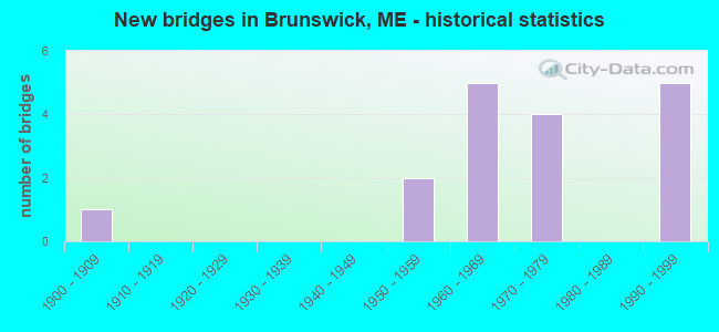
- New bridges - historical statistics
- 11900-1909
- 21950-1959
- 51960-1969
- 41970-1979
- 51990-1999

- Reconstructed bridges - Historical Statistics
- 21980-1989
- 21990-1999
- 12000-2009


- Bridge Condition - Deck
- 14.3%Very good
- 28.6%Good
- 28.6%Satisfactory
- 21.4%Fair
- 7.1%Poor

- Bridge Condition - Superstructure
- 28.6%Very good
- 35.7%Good
- 28.6%Satisfactory
- 7.1%Poor

- Bridge Condition - Substructure
- 20.0%Very good
- 26.7%Good
- 40.0%Satisfactory
- 13.3%Fair
Find on map >> Show street view
Structure Number: 1142, Location: 295 1.6 MI SB OF TOPSHAM (Lat: 43.917719, Lng: -70.020119), Route carried "on" structure: Ramp State highway , Year Built: 1990, Status: Open, Structure Length: 8.56m (28.08ft), Average Daily Traffic: 1,650 (year 2016), Truck Traffic: 10%, Average Future Daily Traffic: 2,475 (year 2036), Design Load: HS 25 or greater, Features Intersected: I-295 N.B. & S. B., Facility Carried by Structure: I-95 SB OFF RAMP T
Minimum Vertical Clearance: 30+ m (98+ ft), Kilometerpoint: 0.885, Lanes on structure: 1, Lanes under structure: 4, Owner: State Highway Agency, Approaching Roadway Width: 12.2m (40.0ft), Skew: 3 degrees, Material/Design: Steel continuous, Design/Construction: Stringer/Multi-beam, Number Of Spans In Main Unit: 2, Length of Maximum Span: 41.5m (136.2ft), Curb or Sidewalk Widths: Left: 0.2m (0.7ft), Right: 0.2m (0.7ft), Curb-To-Curb Width: 6.1m (20.0ft), Out-to-Out Width: 7.2m (23.6ft)
Condition: Deck: Good, Superstructure: Good, Substructure: Satisfactory, Operating Rating: 51.2 metric tons, Method Used To Determine Operating Rating: Load and Resistance Factor Rating (LRFR) rating reported by rating factor(RF) method using HL-93 loadings, Inventory Rating: 39.2 metric tons, Method Used To Determine Inventory Rating: Load and Resistance Factor Rating (LRFR) rating reported by rating factor(RF) method using HL-93 loadings, Structural Evaluation: Equal to present minimum criteria, Deck Geometry: Somewhat better than minimum adequacy, Underclear: Meets minimum limits, Approach Roadway Alignment: Equal to present desirable criteria, Designated Inspection Frequency: Every 24 months, Inspection Date: September 2021, Deck Structure Type: Concrete Cast-file-Place, Wearing Surface/Protective System: Wearing Surface: Bituminous, Membrane: Preformed Fabric
Find on map >> Show street view
Structure Number: 5685, Location: .8 MI NW'LY OF US1 (Lat: 43.914831, Lng: -70.029181), Route carried "on" structure: City street , Year Built: 1957, Year Reconstructed: 2002, Status: Open, Structure Length: 8.00m (26.25ft), Average Daily Traffic: 3,421 (year 2016), Truck Traffic: 5%, Average Future Daily Traffic: 4,789 (year 2036), Design Load: H 20, Features Intersected: I-295, Facility Carried by Structure: DURHAM RD
Minimum Vertical Clearance: 30+ m (98+ ft), Kilometerpoint: 4.216, Lanes on structure: 2, Lanes under structure: 4, Owner: State Highway Agency, Approaching Roadway Width: 8.8m (28.9ft), Skew: 4 degrees, Material/Design: Steel continuous, Design/Construction: Stringer/Multi-beam, Number Of Spans In Main Unit: 4, Length of Maximum Span: 22.3m (73.2ft), Curb or Sidewalk Widths: Left: 0.5m (1.6ft), Right: 0.5m (1.6ft), Curb-To-Curb Width: 7.3m (24.0ft), Out-to-Out Width: 8.8m (28.9ft)
Condition: Deck: Good, Superstructure: Poor, Substructure: Fair, Operating Rating: 46.3 metric tons, Method Used To Determine Operating Rating: Load and Resistance Factor Rating (LRFR) rating reported by rating factor(RF) method using HL-93 loadings, Inventory Rating: 36.0 metric tons, Method Used To Determine Inventory Rating: Load and Resistance Factor Rating (LRFR) rating reported by rating factor(RF) method using HL-93 loadings, Structural Evaluation: Meets minimum limits, Deck Geometry: High priority of replacement, Underclear: High priority of corrective action, Approach Roadway Alignment: Equal to present desirable criteria, Designated Inspection Frequency: Every 24 months, Inspection Date: June 2021, Deck Structure Type: Concrete Cast-file-Place, Wearing Surface/Protective System: Wearing Surface: Bituminous, Membrane: Preformed Fabric
Find on map >> Show street view
Structure Number: 5884, Location: 0.2 MI S OF TOPSHAM T.L. (Lat: 43.918300, Lng: -69.966631), Route carried "on" structure: State highway 24, Year Built: 1961, Year Reconstructed: 1985, Status: Open, Structure Length: 2.47m (8.10ft), Average Daily Traffic: 9,185 (year 2016), Truck Traffic: 5%, Average Future Daily Traffic: 12,859 (year 2036), Design Load: HS 20, Features Intersected: US 1
Minimum Vertical Clearance: 30+ m (98+ ft), Kilometerpoint: 4.748, Lanes on structure: 5, Lanes under structure: 4, Base Highway Network: Yes, Owner: State Highway Agency, Approaching Roadway Width: 23.2m (76.1ft), Skew: 20 degrees, Material/Design: Steel, Design/Construction: Stringer/Multi-beam, Number Of Spans In Main Unit: 1, Length of Maximum Span: 22.9m (75.1ft), Curb or Sidewalk Widths: Left: 4.5m (14.8ft), Right: 2.1m (6.9ft), Curb-To-Curb Width: 20.2m (66.3ft), Out-to-Out Width: 28.0m (91.9ft)
Condition: Deck: Poor, Superstructure: Satisfactory, Substructure: Good, Operating Rating: 49.6 metric tons, Method Used To Determine Operating Rating: Load and Resistance Factor Rating (LRFR) rating reported by rating factor(RF) method using HL-93 loadings, Inventory Rating: 38.2 metric tons, Method Used To Determine Inventory Rating: Load and Resistance Factor Rating (LRFR) rating reported by rating factor(RF) method using HL-93 loadings, Structural Evaluation: Equal to present minimum criteria, Deck Geometry: Somewhat better than minimum adequacy, Underclear: High priority of corrective action, Approach Roadway Alignment: Equal to present desirable criteria, Designated Inspection Frequency: Every 24 months, Inspection Date: May 2021, Deck Structure Type: Concrete Cast-file-Place, Wearing Surface/Protective System: Wearing Surface: Monolithic Concrete
Find on map >> Show street view
Structure Number: 5886, Location: .5 MI E'LY OF ROUTE 201 (Lat: 43.919231, Lng: -69.956050), Year Built: 1961, Status: Open, Structure Length: 5.70m (18.70ft), Average Future Daily Traffic: 18,003 (year 2034), Design Load: Railroad, Features Intersected: US1&2 EA RTE 196 RAMPS
Lanes under structure: 6, Owner: State Highway Agency, Skew: 1 degrees, Material/Design: Steel, Design/Construction: Stringer/Multi-beam, Number Of Spans In Main Unit: 4, Length of Maximum Span: 14.8m (48.6ft), Curb or Sidewalk Widths: Left: 0.0m, Right: 0.9m (3.0ft), Out-to-Out Width: 4.9m (16.1ft)
Condition: Substructure: Good, Structural Evaluation: Better than present minimum criteria, Underclear: High priority of corrective action, Designated Inspection Frequency: Every 24 months, Inspection Date: December 2020
Find on map >> Show street view
Structure Number: 6032, Location: 2.7 MI E US201 (Lat: 43.910119, Lng: -69.916089), Route carried "on" structure: Ramp State highway , Year Built: 1964, Status: Open, Structure Length: 10.24m (33.60ft), Average Daily Traffic: 3,653 (year 2016), Truck Traffic: 7%, Average Future Daily Traffic: 5,114 (year 2036), Design Load: HS 20+Mod, Features Intersected: US 1 & US1 ON RAMP, Facility Carried by Structure: US1 & RTE24 ON&OFF
Minimum Vertical Clearance: 30+ m (98+ ft), Kilometerpoint: 0.595, Lanes on structure: 2, Lanes under structure: 5, Owner: State Highway Agency, Approaching Roadway Width: 15.5m (50.9ft), Skew: 22 degrees, Material/Design: Steel, Design/Construction: Stringer/Multi-beam, Number Of Spans In Main Unit: 6, Length of Maximum Span: 25.3m (83.0ft), Curb or Sidewalk Widths: Left: 0.1m (0.3ft), Right: 0.1m (0.3ft), Curb-To-Curb Width: 17.4m (57.1ft), Out-to-Out Width: 18.3m (60.0ft)
Condition: Deck: Satisfactory, Superstructure: Good, Substructure: Satisfactory, Operating Rating: 59.3 metric tons, Method Used To Determine Operating Rating: Load and Resistance Factor Rating (LRFR) rating reported by rating factor(RF) method using HL-93 loadings, Inventory Rating: 45.7 metric tons, Method Used To Determine Inventory Rating: Load and Resistance Factor Rating (LRFR) rating reported by rating factor(RF) method using HL-93 loadings, Structural Evaluation: Equal to present minimum criteria, Deck Geometry: Superior to present desirable criteria, Underclear: High priority of corrective action, Approach Roadway Alignment: Equal to present desirable criteria, Designated Inspection Frequency: Every 24 months, Inspection Date: December 2020, Deck Structure Type: Concrete Cast-file-Place, Wearing Surface/Protective System: Wearing Surface: Bituminous, Membrane: Preformed Fabric
Find on map >> Show street view
Structure Number: 6033, Location: 0.1 MI N'LY OF BATH ROAD (Lat: 43.912350, Lng: -69.907350), Route carried "on" structure: County highway , Year Built: 1964, Year Reconstructed: 1992, Status: Open, Structure Length: 11.53m (37.83ft), Average Daily Traffic: 5,553 (year 2016), Truck Traffic: 5%, Average Future Daily Traffic: 7,774 (year 2036), Design Load: HS 20, Features Intersected: US 1, Facility Carried by Structure: OLD BATH ROAD
Minimum Vertical Clearance: 30+ m (98+ ft), Kilometerpoint: 8.127, Lanes on structure: 2, Lanes under structure: 4, Owner: State Highway Agency, Approaching Roadway Width: 9.1m (29.9ft), Skew: 2 degrees, Material/Design: Steel, Design/Construction: Stringer/Multi-beam, Number Of Spans In Main Unit: 6, Length of Maximum Span: 19.4m (63.6ft), Curb or Sidewalk Widths: Left: 0.4m (1.3ft), Right: 0.4m (1.3ft), Curb-To-Curb Width: 8.5m (27.9ft), Out-to-Out Width: 10.2m (33.5ft)
Condition: Deck: Fair, Superstructure: Satisfactory, Substructure: Satisfactory, Operating Rating: 51.2 metric tons, Method Used To Determine Operating Rating: Load and Resistance Factor Rating (LRFR) rating reported by rating factor(RF) method using HL-93 loadings, Inventory Rating: 39.5 metric tons, Method Used To Determine Inventory Rating: Load and Resistance Factor Rating (LRFR) rating reported by rating factor(RF) method using HL-93 loadings, Structural Evaluation: Equal to present minimum criteria, Deck Geometry: Meets minimum limits, Underclear: High priority of corrective action, Approach Roadway Alignment: Equal to present desirable criteria, Designated Inspection Frequency: Every 24 months, Inspection Date: May 2021, Deck Structure Type: Concrete Cast-file-Place, Wearing Surface/Protective System: Wearing Surface: Bituminous, Membrane: Preformed Fabric
Find on map >> Show street view
Structure Number: 6146, Location: BRUNSWICK-W.BATH TL (Lat: 43.917989, Lng: -69.865189), Route carried "on" structure: State highway 1, Year Built: 1966, Status: Open, Structure Length: 2.53m (8.30ft), Average Daily Traffic: 16,567 (year 2016), Truck Traffic: 5%, Average Future Daily Traffic: 23,194 (year 2036), Design Load: HS 20, Features Intersected: NEW MEADOWS RIVER
Minimum Vertical Clearance: 30+ m (98+ ft), Kilometerpoint: 130.630, Lanes on structure: 2, Base Highway Network: Yes, Owner: State Highway Agency, Approaching Roadway Width: 11.3m (37.1ft), Navigation Control: Yes ( Vertical Clearance: 2.4m (7.9ft), Horizontal Clearance: 14.6m (47.9ft)), Material/Design: Steel, Design/Construction: Stringer/Multi-beam, Number Of Spans In Main Unit: 1, Length of Maximum Span: 23.8m (78.1ft), Curb or Sidewalk Widths: Left: 0.1m (0.3ft), Right: 0.1m (0.3ft), Curb-To-Curb Width: 11.5m (37.7ft), Out-to-Out Width: 12.2m (40.0ft)
Condition: Deck: Fair, Superstructure: Good, Substructure: Satisfactory, Channel: Good, Operating Rating: 73.2 metric tons, Method Used To Determine Operating Rating: Load and Resistance Factor Rating (LRFR) rating reported by rating factor(RF) method using HL-93 loadings, Inventory Rating: 56.4 metric tons, Method Used To Determine Inventory Rating: Load and Resistance Factor Rating (LRFR) rating reported by rating factor(RF) method using HL-93 loadings, Structural Evaluation: Equal to present minimum criteria, Deck Geometry: Equal to present minimum criteria, Waterway Adequacy: Superior to present desirable criteria, Approach Roadway Alignment: Equal to present desirable criteria, Designated Inspection Frequency: Every 24 months, Inspection Date: July 2021, Deck Structure Type: Concrete Cast-file-Place, Wearing Surface/Protective System: Wearing Surface: Integral Concrete
Find on map >> Show street view
Structure Number: 6267, Location: 1.5 MI. NW'LY JCT US1 (Lat: 43.927839, Lng: -69.999489), Route carried "on" structure: County highway , Year Built: 1973, Status: Open, Structure Length: 8.14m (26.71ft), Average Daily Traffic: 2,960 (year 2016), Truck Traffic: 5%, Average Future Daily Traffic: 4,144 (year 2036), Design Load: HS 20, Features Intersected: I-295, Facility Carried by Structure: RIVER ROAD
Minimum Vertical Clearance: 30+ m (98+ ft), Kilometerpoint: 0.016, Lanes on structure: 2, Lanes under structure: 4, Owner: State Highway Agency, Approaching Roadway Width: 11.6m (38.1ft), Skew: 1 degrees, Material/Design: Steel continuous, Design/Construction: Stringer/Multi-beam, Number Of Spans In Main Unit: 2, Length of Maximum Span: 39.9m (130.9ft), Curb or Sidewalk Widths: Left: 0.2m (0.7ft), Right: 0.2m (0.7ft), Curb-To-Curb Width: 9.8m (32.2ft), Out-to-Out Width: 11.0m (36.1ft)
Condition: Deck: Satisfactory, Superstructure: Very good, Substructure: Good, Operating Rating: 67.4 metric tons, Method Used To Determine Operating Rating: Load and Resistance Factor Rating (LRFR) rating reported by rating factor(RF) method using HL-93 loadings, Inventory Rating: 38.6 metric tons, Method Used To Determine Inventory Rating: Load and Resistance Factor Rating (LRFR) rating reported by rating factor(RF) method using HL-93 loadings, Structural Evaluation: Better than present minimum criteria, Deck Geometry: Meets minimum limits, Underclear: Somewhat better than minimum adequacy, Approach Roadway Alignment: Equal to present desirable criteria, Designated Inspection Frequency: Every 24 months, Inspection Date: December 2020, Deck Structure Type: Concrete Cast-file-Place, Wearing Surface/Protective System: Wearing Surface: Bituminous, Membrane: Preformed Fabric
Find on map >> Show street view
Structure Number: 6268, Location: BRUNS-TOPSHAM TL (Lat: 43.931300, Lng: -69.993161), Route carried "on" structure: State highway 295, Year Built: 1971, Status: Open, Structure Length: 25.34m (83.14ft), Average Daily Traffic: 16,310 (year 2016), Truck Traffic: 10%, Average Future Daily Traffic: 22,834 (year 2036), Design Load: HS 20+Mod, Features Intersected: ANDROSCOGGIN RIVER
Minimum Vertical Clearance: 30+ m (98+ ft), Kilometerpoint: 48.232, Lanes on structure: 2, Base Highway Network: Yes, Owner: State Highway Agency, Approaching Roadway Width: 12.8m (42.0ft), Navigation Control: Yes ( Vertical Clearance: 12.2m (40.0ft), Horizontal Clearance: 52.4m (171.9ft)), Material/Design: Steel continuous, Design/Construction: Stringer/Multi-beam, Number Of Spans In Main Unit: 5, Length of Maximum Span: 55.8m (183.1ft), Curb or Sidewalk Widths: Left: 0.2m (0.7ft), Right: 0.2m (0.7ft), Curb-To-Curb Width: 12.9m (42.3ft), Out-to-Out Width: 13.7m (44.9ft)
Condition: Deck: Fair, Superstructure: Good, Substructure: Satisfactory, Channel: Good, Operating Rating: 41.5 metric tons, Method Used To Determine Operating Rating: Load and Resistance Factor Rating (LRFR) rating reported by rating factor(RF) method using HL-93 loadings, Inventory Rating: 32.4 metric tons, Method Used To Determine Inventory Rating: Load and Resistance Factor Rating (LRFR) rating reported by rating factor(RF) method using HL-93 loadings, Structural Evaluation: Equal to present minimum criteria, Deck Geometry: Superior to present desirable criteria, Waterway Adequacy: Superior to present desirable criteria, Approach Roadway Alignment: Equal to present desirable criteria, Designated Inspection Frequency: Every 24 months, Underwater Inspection Frequency: Every 60 months, Inspection Date: September 2021, Underwater Inspection Date: October 2019, Deck Structure Type: Concrete Cast-file-Place, Wearing Surface/Protective System: Wearing Surface: Bituminous, Membrane: Preformed Fabric
Find on map >> Show street view
Structure Number: 6286, Location: 295 1.6 MI SB OF TOPSHAM (Lat: 43.917811, Lng: -70.019911), Route carried "on" structure: Ramp State highway , Year Built: 1972, Year Reconstructed: 1990, Status: Open, Structure Length: 8.41m (27.59ft), Average Daily Traffic: 10,630 (year 2016), Truck Traffic: 5%, Average Future Daily Traffic: 14,882 (year 2036), Design Load: HS 20+Mod, Features Intersected: I-295, Facility Carried by Structure: US 1 WB
Minimum Vertical Clearance: 30+ m (98+ ft), Kilometerpoint: 0.547, Lanes on structure: 2, Lanes under structure: 4, Owner: State Highway Agency, Approaching Roadway Width: 12.2m (40.0ft), Skew: 2 degrees, Material/Design: Steel continuous, Design/Construction: Stringer/Multi-beam, Number Of Spans In Main Unit: 2, Length of Maximum Span: 44.2m (145.0ft), Curb or Sidewalk Widths: Left: 0.2m (0.7ft), Right: 0.2m (0.7ft), Curb-To-Curb Width: 12.6m (41.3ft), Out-to-Out Width: 13.7m (44.9ft)
Condition: Deck: Satisfactory, Superstructure: Satisfactory, Substructure: Fair, Operating Rating: 43.4 metric tons, Method Used To Determine Operating Rating: Load and Resistance Factor Rating (LRFR) rating reported by rating factor(RF) method using HL-93 loadings, Inventory Rating: 33.4 metric tons, Method Used To Determine Inventory Rating: Load and Resistance Factor Rating (LRFR) rating reported by rating factor(RF) method using HL-93 loadings, Structural Evaluation: Somewhat better than minimum adequacy, Deck Geometry: Superior to present desirable criteria, Underclear: Meets minimum limits, Approach Roadway Alignment: Equal to present desirable criteria, Designated Inspection Frequency: Every 24 months, Inspection Date: May 2021, Deck Structure Type: Concrete Cast-file-Place, Wearing Surface/Protective System: Wearing Surface: Integral Concrete
Find on map >> Show street view
Structure Number: 6287, Location: 0.9 MI NW'LY OF US1 (Lat: 43.915150, Lng: -70.030469), Route carried "on" structure: City street , Year Built: 1973, Status: Open, Structure Length: 3.87m (12.70ft), Average Daily Traffic: 3,421 (year 2016), Truck Traffic: 5%, Average Future Daily Traffic: 4,789 (year 2036), Design Load: HS 20, Features Intersected: WB US1 RAMP TO 295 SB, Facility Carried by Structure: DURHAM RD
Minimum Vertical Clearance: 30+ m (98+ ft), Kilometerpoint: 4.104, Lanes on structure: 2, Lanes under structure: 2, Owner: State Highway Agency, Approaching Roadway Width: 8.8m (28.9ft), Skew: 2 degrees, Material/Design: Steel, Design/Construction: Stringer/Multi-beam, Number Of Spans In Main Unit: 1, Length of Maximum Span: 36.9m (121.1ft), Curb or Sidewalk Widths: Left: 0.2m (0.7ft), Right: 0.2m (0.7ft), Curb-To-Curb Width: 11.9m (39.0ft), Out-to-Out Width: 13.2m (43.3ft)
Condition: Deck: Satisfactory, Superstructure: Satisfactory, Substructure: Satisfactory, Operating Rating: 73.9 metric tons, Method Used To Determine Operating Rating: Load and Resistance Factor Rating (LRFR) rating reported by rating factor(RF) method using HL-93 loadings, Inventory Rating: 42.4 metric tons, Method Used To Determine Inventory Rating: Load and Resistance Factor Rating (LRFR) rating reported by rating factor(RF) method using HL-93 loadings, Structural Evaluation: Equal to present minimum criteria, Deck Geometry: Somewhat better than minimum adequacy, Underclear: Equal to present minimum criteria, Approach Roadway Alignment: Equal to present desirable criteria, Designated Inspection Frequency: Every 24 months, Inspection Date: May 2021, Deck Structure Type: Concrete Cast-file-Place, Wearing Surface/Protective System: Wearing Surface: Bituminous, Membrane: Preformed Fabric
Find on map >> Show street view
Structure Number: 6371, Location: BRUNSWICK TOPSHAM T.L. (Lat: 43.922381, Lng: -69.952750), Route carried "on" structure: State highway 24, Year Built: 1997, Status: Open, Structure Length: 33.10m (108.60ft), Average Daily Traffic: 22,360 (year 2016), Truck Traffic: 5%, Average Future Daily Traffic: 31,304 (year 2036), Design Load: HS 25 or greater, Features Intersected: ANDROSCOGGIN RIVER, Facility Carried by Structure: ROUTE 196
Minimum Vertical Clearance: 30+ m (98+ ft), Kilometerpoint: 27.134, Lanes on structure: 4, Base Highway Network: Yes, Owner: State Highway Agency, Approaching Roadway Width: 18.3m (60.0ft), Skew: 1 degrees, Navigation Control: Yes ( Vertical Clearance: 7.6m (24.9ft), Horizontal Clearance: 56.4m (185.0ft)), Material/Design: Steel continuous, Design/Construction: Stringer/Multi-beam, Number Of Spans In Main Unit: 6, Length of Maximum Span: 58.8m (192.9ft), Curb or Sidewalk Widths: Left: 0.1m (0.3ft), Right: 2.4m (7.9ft), Curb-To-Curb Width: 18.3m (60.0ft), Out-to-Out Width: 21.9m (71.9ft)
Condition: Deck: Good, Superstructure: Good, Substructure: Good, Channel: Good, Operating Rating: 65.8 metric tons, Method Used To Determine Operating Rating: Load and Resistance Factor Rating (LRFR) rating reported by rating factor(RF) method using HL-93 loadings, Inventory Rating: 39.2 metric tons, Method Used To Determine Inventory Rating: Load and Resistance Factor Rating (LRFR) rating reported by rating factor(RF) method using HL-93 loadings, Structural Evaluation: Better than present minimum criteria, Deck Geometry: Somewhat better than minimum adequacy, Waterway Adequacy: Superior to present desirable criteria, Approach Roadway Alignment: Equal to present desirable criteria, Designated Inspection Frequency: Every 24 months, Underwater Inspection Frequency: Every 60 months, Inspection Date: July 2021, Underwater Inspection Date: June 2020, Deck Structure Type: Concrete Cast-file-Place, Wearing Surface/Protective System: Wearing Surface: Bituminous, Membrane: Preformed Fabric, Deck Protection: Epoxy Coated Reinforcing
Find on map >> Show street view
Structure Number: 6372, Location: S'LY END OF ROUTE 196 (Lat: 43.919350, Lng: -69.953219), Route carried "on" structure: Ramp State highway 24, Year Built: 1997, Status: Open, Structure Length: 10.06m (33.01ft), Average Daily Traffic: 8,514 (year 2016), Truck Traffic: 7%, Average Future Daily Traffic: 11,920 (year 2036), Design Load: HS 25 or greater, Features Intersected: ROUTE US1, Facility Carried by Structure: ROUTE 196 SOUTHBOU
Minimum Vertical Clearance: 5.44m (17.85ft), Kilometerpoint: 0.515, Lanes on structure: 1, Lanes under structure: 4, Owner: State Highway Agency, Approaching Roadway Width: 7.9m (25.9ft), Material/Design: Steel continuous, Design/Construction: Stringer/Multi-beam, Number Of Spans In Main Unit: 4, Length of Maximum Span: 28.3m (92.8ft), Curb or Sidewalk Widths: Left: 0.2m (0.7ft), Right: 0.2m (0.7ft), Curb-To-Curb Width: 7.9m (25.9ft), Out-to-Out Width: 8.7m (28.5ft)
Condition: Deck: Very good, Superstructure: Very good, Substructure: Very good, Operating Rating: 47.3 metric tons, Method Used To Determine Operating Rating: Load and Resistance Factor Rating (LRFR) rating reported by rating factor(RF) method using HL-93 loadings, Inventory Rating: 36.3 metric tons, Method Used To Determine Inventory Rating: Load and Resistance Factor Rating (LRFR) rating reported by rating factor(RF) method using HL-93 loadings, Structural Evaluation: Equal to present desirable criteria, Deck Geometry: Equal to present desirable criteria, Underclear: Meets minimum limits, Approach Roadway Alignment: Somewhat better than minimum adequacy, Designated Inspection Frequency: Every 24 months, Inspection Date: August 2020, Deck Structure Type: Concrete Cast-file-Place, Wearing Surface/Protective System: Wearing Surface: Integral Concrete, Deck Protection: Epoxy Coated Reinforcing
Find on map >> Show street view
Structure Number: 6373, Location: S'LY BEGINNING OF RTE 196 (Lat: 43.919281, Lng: -69.953231), Route carried "on" structure: Ramp State highway , Year Built: 1997, Status: Open, Structure Length: 12.80m (41.99ft), Average Daily Traffic: 1,404 (year 2016), Truck Traffic: 7%, Average Future Daily Traffic: 2,106 (year 2036), Design Load: HS 25 or greater, Features Intersected: Ramp B, Facility Carried by Structure: ROUTE 196 NORTHBOU
Minimum Vertical Clearance: 7.62m (25.00ft), Kilometerpoint: 0.193, Lanes on structure: 1, Lanes under structure: 4, Owner: State Highway Agency, Approaching Roadway Width: 7.9m (25.9ft), Material/Design: Steel continuous, Design/Construction: Stringer/Multi-beam, Number Of Spans In Main Unit: 5, Length of Maximum Span: 27.4m (89.9ft), Curb or Sidewalk Widths: Left: 0.2m (0.7ft), Right: 0.2m (0.7ft), Curb-To-Curb Width: 7.9m (25.9ft), Out-to-Out Width: 8.7m (28.5ft)
Condition: Deck: Good, Superstructure: Very good, Substructure: Very good, Operating Rating: 66.7 metric tons, Method Used To Determine Operating Rating: Load and Resistance Factor Rating (LRFR) rating reported by rating factor(RF) method using HL-93 loadings, Inventory Rating: 51.5 metric tons, Method Used To Determine Inventory Rating: Load and Resistance Factor Rating (LRFR) rating reported by rating factor(RF) method using HL-93 loadings, Structural Evaluation: Equal to present desirable criteria, Deck Geometry: Equal to present desirable criteria, Underclear: Meets minimum limits, Approach Roadway Alignment: Equal to present desirable criteria, Designated Inspection Frequency: Every 24 months, Inspection Date: August 2020, Deck Structure Type: Concrete Cast-file-Place, Wearing Surface/Protective System: Wearing Surface: Monolithic Concrete, Deck Protection: Epoxy Coated Reinforcing
Find on map >> Show street view
Structure Number: 6402, Location: US 1 OFF RAMP (Lat: 43.911539, Lng: -69.914769), Year Built: 1998, Year Reconstructed: 2012, Status: Open, Structure Length: 4.33m (14.21ft), Design Load: Pedestrian, Features Intersected: US ROUTE 1 OFFRAMP
Lanes under structure: 2, Owner: Town or Township Highway Agency, Material/Design: Steel, Design/Construction: Truss - Thru, Number Of Spans In Main Unit: 1, Length of Maximum Span: 42.1m (138.1ft), Curb or Sidewalk Widths: Left: 0.3m (1.0ft), Right: 0.3m (1.0ft), Out-to-Out Width: 3.7m (12.1ft)
Condition: Deck: Very good, Superstructure: Very good, Substructure: Very good, Operating Rating: 10.3 metric tons, Method Used To Determine Operating Rating: Load Factor (LF), Inventory Rating: 7.4 metric tons, Method Used To Determine Inventory Rating: Load Factor (LF), Structural Evaluation: Equal to present desirable criteria, Underclear: Equal to present minimum criteria, Approach Roadway Alignment: Equal to present desirable criteria, Bridge Posting: Required (Relationship of Operating Rating to Maximum Legal Load: 30.0 - 39.9% below), Designated Inspection Frequency: Every 24 months, Inspection Date: August 2020, Deck Structure Type: Corrugated Steel, Wearing Surface/Protective System: Wearing Surface: Monolithic Concrete
Find on map >> Show street view
Location: .2 MI N PLEASANT ST (Lat: 43.915831, Lng: -69.974511), Route carried "under" structure: Bypass State highway 32210, Year Built: 1957, Structure Length: 0. m, Features Intersected: US #1 (MILL STREET), Facility Carried by Structure: STATE OF MAINE RR
Lanes on structure: 1, Lanes under structure: 2, Material/Design: Steel, Design/Construction: Girder and Floorbeam System, Length of Maximum Span: 22.4m (73.5ft)
Find on map >> Show street view
Location: .3 MI E FEDERAL ST (Lat: 43.914931, Lng: -69.957192), Route carried "under" structure: State highway 42500, Structure Length: 0. m, Average Daily Traffic: 1,596 (year 2014), Truck Traffic: 5%, Features Intersected: M.C.R.R, Facility Carried by Structure: JORDAN AVENUE
Minimum Vertical Clearance: 3.48m (11.42ft), Kilometerpoint: 0.370, Lanes on structure: 4, Length of Maximum Span: 0.0m
Find on map >> Show street view
Location: JCT FREE BR & MILL RD (Lat: 43.916181, Lng: -69.975231), Route carried "under" structure: 92023, Year Built: 1900, Structure Length: 0. m, Features Intersected: MILL ROAD, Facility Carried by Structure: Lewiston Lower
Minimum Vertical Clearance: 30+ m (98+ ft), Lanes on structure: 1, Lanes under structure: 2, Material/Design: Steel, Design/Construction: Truss - Thru, Length of Maximum Span: 5.8m (19.0ft)
Find on map >> Show street view
Location: X'S RTE 1 0.7 MI. W. 209 (Lat: 43.907256, Lng: -69.966628), Route carried "under" structure: Spur Interstate 22310, Structure Length: 0. m, Average Daily Traffic: 14,049 (year 2014), Truck Traffic: 7%, Features Intersected: CONGRESS AVE., Facility Carried by Structure: US 1
Minimum Vertical Clearance: 4.59m (15.06ft), Kilometerpoint: 133.527, Lanes on structure: 4, Length of Maximum Span: 0.0m
Find on map >> Show street view
Location: 0.2 MI E TOWNLINE (Lat: 43.917486, Lng: -69.862253), Route carried "under" structure: Spur Interstate 52310, Structure Length: 0. m, Average Daily Traffic: 15,104 (year 2014), Truck Traffic: 9%, Features Intersected: NEW MEADOWS ROAD, Facility Carried by Structure: ROUTE US 1
Minimum Vertical Clearance: 4.52m (14.83ft), Kilometerpoint: 130.856, Lanes on structure: 6, Length of Maximum Span: 0.0m
Find on map >> Show street view
Location: 1.5 MI. NW'LY JCT US1 (Lat: 43.927839, Lng: -69.999486), Route carried "under" structure: Business US 72310, Structure Length: 0. m, Average Daily Traffic: 15,050 (year 2014), Truck Traffic: 11%, Features Intersected: RIVER ROAD, Facility Carried by Structure: I-95
Minimum Vertical Clearance: 5.18m (16.99ft), Kilometerpoint: 47.460, Lanes on structure: 4, Length of Maximum Span: 0.0m
Find on map >> Show street view
Location: 295 1.6 MI SB OF TOPSHAM (Lat: 43.917808, Lng: -70.019906), Route carried "under" structure: ServiceUS 62310, Structure Length: 0. m, Average Daily Traffic: 13,550 (year 2014), Truck Traffic: 11%, Features Intersected: US 1 WB, Facility Carried by Structure: I-295
Minimum Vertical Clearance: 5.23m (17.16ft), Kilometerpoint: 45.738, Lanes on structure: 4, Length of Maximum Span: 0.0m
Find on map >> Show street view
Location: 0.9 MI NW'LY OF US1 (Lat: 43.915144, Lng: -70.030469), Route carried "under" structure: ServiceUS 72500, Structure Length: 0. m, Average Daily Traffic: 3,583 (year 2014), Truck Traffic: 5%, Features Intersected: DURHAM RD, Facility Carried by Structure: WB US1 RAMP TO 295
Minimum Vertical Clearance: 5.36m (17.59ft), Kilometerpoint: 4.104, Lanes on structure: 4, Length of Maximum Span: 0.0m
Find on map >> Show street view
Location: S'LY END OF ROUTE 196 (Lat: 43.919353, Lng: -69.953219), Route carried "under" structure: Ramp State highway 22310, Structure Length: 0. m, Average Daily Traffic: 12,859 (year 2014), Truck Traffic: 7%, Features Intersected: ROUTE 196 SOUTHBOU, Facility Carried by Structure: ROUTE US1
Minimum Vertical Clearance: 5.20m (17.06ft), Kilometerpoint: 123.002, Lanes on structure: 2, Length of Maximum Span: 0.0m
Find on map >> Show street view
Location: S'LY BEGINNING OF RTE 196 (Lat: 43.919281, Lng: -69.953231), Route carried "under" structure: Ramp State highway 32310, Structure Length: 0. m, Average Daily Traffic: 12,859 (year 2014), Truck Traffic: 7%, Features Intersected: ROUTE 196 NORTHBOU, Facility Carried by Structure: ROUTE US1 AND RAMP
Minimum Vertical Clearance: 5.43m (17.81ft), Kilometerpoint: 122.793, Lanes on structure: 2, Length of Maximum Span: 0.0m
Find on map >> Show street view
Location: US 1 OFF RAMP (Lat: 43.911536, Lng: -69.914769), Route carried "under" structure: County highway 22370, Structure Length: 0. m, Average Daily Traffic: 7,081 (year 2014), Truck Traffic: 7%, Features Intersected: PEDESTRIAN & BICYC, Facility Carried by Structure: US ROUTE 1 OFFRAMP
Minimum Vertical Clearance: 5.03m (16.50ft), Kilometerpoint: 23.255, Lanes on structure: 1, Length of Maximum Span: 0.0m