Bridge Statistics for Brunswick, New York (NY)
Condition, Traffic, Stress, Structural Evaluation, Project Costs
- National Bridge Inventory (NBI) Statistics
- 11Number of bridges
- 66ft / 19.7mTotal length
- $12,571,000Total costs
- 26,975Total average daily traffic
- 3,583Total average daily truck traffic
- 28,612Total future (year 2037) average daily traffic
- National Bridge Inventory (NBI) Registered Bridges for Brunswick
- No street view available for this location
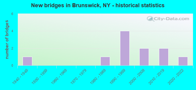
- New bridges - historical statistics
- 11940-1949
- 11980-1989
- 41990-1999
- 22000-2009
- 22010-2019
- 12020-2022
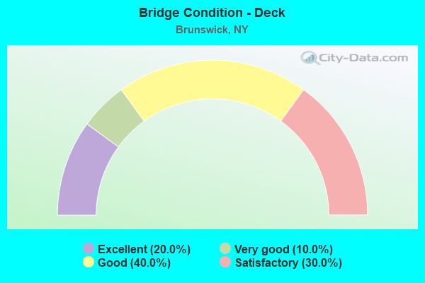
- Bridge Condition - Deck
- 20.0%Excellent
- 10.0%Very good
- 40.0%Good
- 30.0%Satisfactory
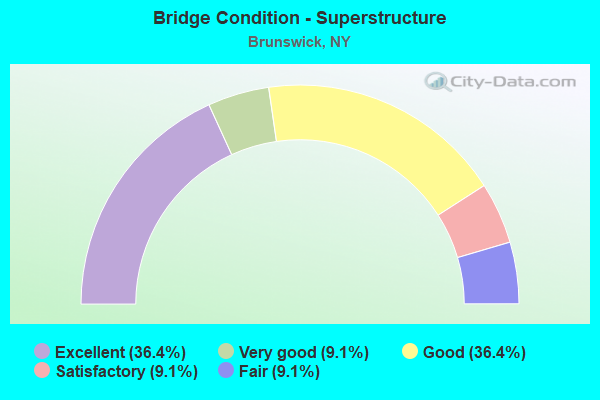
- Bridge Condition - Superstructure
- 36.4%Excellent
- 9.1%Very good
- 36.4%Good
- 9.1%Satisfactory
- 9.1%Fair
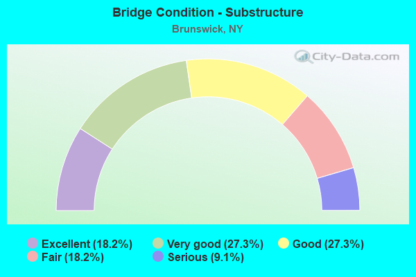
- Bridge Condition - Substructure
- 18.2%Excellent
- 27.3%Very good
- 27.3%Good
- 18.2%Fair
- 9.1%Serious
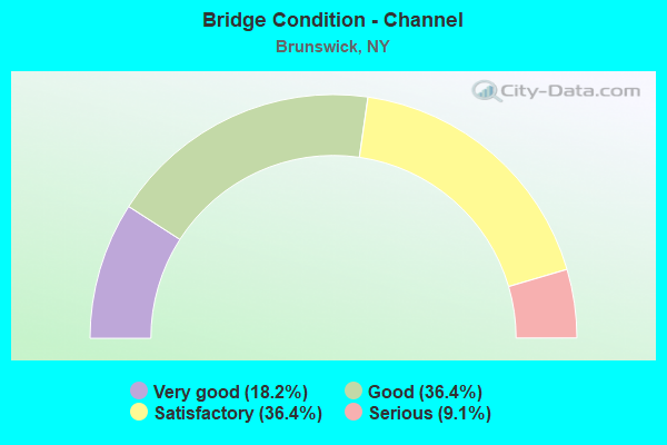
- Bridge Condition - Channel
- 18.2%Very good
- 36.4%Good
- 36.4%Satisfactory
- 9.1%Serious
Find on map >> Show street view
Structure Number: 100019, Location: 2.5 MI E JCT RTS 66 & 2 (Lat: 42.732839, Lng: -73.631472), Route carried "on" structure: US 2, Year Built: 2021, Status: Open, Structure Length: 3.87m (12.70ft), Average Daily Traffic: 3,318 (year 2020), Truck Traffic: 9%, Average Future Daily Traffic: 3,333 (year 2040), Design Load: HL 93, Features Intersected: POESTEN KILL
Minimum Vertical Clearance: 30+ m (98+ ft), Kilometerpoint: 6.066, Lanes on structure: 2, Base Highway Network: Yes, Owner: State Highway Agency, Approaching Roadway Width: 9.8m (32.2ft), Skew: 3 degrees, Material/Design: Steel, Design/Construction: Stringer/Multi-beam, Number Of Spans In Main Unit: 1, Length of Maximum Span: 36.6m (120.1ft), Curb-To-Curb Width: 9.8m (32.2ft), Out-to-Out Width: 11.0m (36.1ft)
Condition: Deck: Excellent, Superstructure: Excellent, Substructure: Excellent, Channel: Very good, Inventory Rating: 67.1 metric tons, Method Used To Determine Inventory Rating: Load Factor (LF), Structural Evaluation: Superior to present desirable criteria, Deck Geometry: Meets minimum limits, Waterway Adequacy: Equal to present desirable criteria, Approach Roadway Alignment: Equal to present desirable criteria, Length Of Structure Improvement: 3.07m (10.07ft), Designated Inspection Frequency: Every 24 months, Inspection Date: December 2021, Bridge Improvement Cost: $2,571,000, Roadway Improvement Cost: $1,505,000, Total Project Cost: $4,076,000 ( Estimate for 2021), Deck Structure Type: Concrete Cast-file-Place, Wearing Surface/Protective System: Wearing Surface: Integral Concrete, Deck Protection: Epoxy Coated Reinforcing
Find on map >> Show street view
Structure Number: 10002, Location: RTE 2 AT EAGLE MILLS (Lat: 42.728992, Lng: -73.603042), Route carried "on" structure: US 2, Year Built: 2006, Status: Open, Structure Length: 1.89m (6.20ft), Average Daily Traffic: 4,098 (year 2020), Truck Traffic: 9%, Average Future Daily Traffic: 4,117 (year 2040), Design Load: HS 20, Features Intersected: POESTEN KILL
Minimum Vertical Clearance: 30+ m (98+ ft), Kilometerpoint: 8.479, Lanes on structure: 2, Base Highway Network: Yes, Owner: State Highway Agency, Approaching Roadway Width: 9.1m (29.9ft), Material/Design: Concrete, Design/Construction: Arch - Deck, Number Of Spans In Main Unit: 1, Length of Maximum Span: 18.3m (60.0ft), Curb or Sidewalk Widths: Left: 1.7m (5.6ft), Right: 1.7m (5.6ft), Curb-To-Curb Width: 9.0m (29.5ft), Out-to-Out Width: 13.6m (44.6ft)
Condition: Superstructure: Good, Substructure: Very good, Channel: Good, Structural Evaluation: Better than present minimum criteria, Deck Geometry: Meets minimum limits, Waterway Adequacy: Equal to present minimum criteria, Approach Roadway Alignment: Equal to present desirable criteria, Length Of Structure Improvement: 1.88m (6.17ft), Designated Inspection Frequency: Every 24 months, Inspection Date: June 2020, Bridge Improvement Cost: $1,154,000, Roadway Improvement Cost: $676,000, Total Project Cost: $1,830,000 ( Estimate for 2021), Wearing Surface/Protective System: Wearing Surface: Bituminous
Find on map >> Show street view
Structure Number: 100021, Location: 0.5 MI E JCT RTS 2 & 351 (Lat: 42.747906, Lng: -73.554319), Route carried "on" structure: US 2, Year Built: 1998, Status: Open, Structure Length: 1.43m (4.69ft), Average Daily Traffic: 4,920 (year 2020), Truck Traffic: 17%, Average Future Daily Traffic: 5,247 (year 2040), Design Load: HS 25 or greater, Features Intersected: QUACKENKILL CREEK
Minimum Vertical Clearance: 30+ m (98+ ft), Kilometerpoint: 13.805, Lanes on structure: 2, Base Highway Network: Yes, Owner: State Highway Agency, Approaching Roadway Width: 9.4m (30.8ft), Skew: 3 degrees, Material/Design: Prestressed concrete, Design/Construction: Box Beam or Girders - Multiple, Number Of Spans In Main Unit: 1, Length of Maximum Span: 13.4m (44.0ft), Curb-To-Curb Width: 9.4m (30.8ft), Out-to-Out Width: 10.1m (33.1ft)
Condition: Deck: Satisfactory, Superstructure: Very good, Substructure: Good, Channel: Satisfactory, Operating Rating: 89.8 metric tons, Method Used To Determine Operating Rating: Load Factor (LF), Inventory Rating: 56.2 metric tons, Method Used To Determine Inventory Rating: Load Factor (LF), Structural Evaluation: Better than present minimum criteria, Deck Geometry: Meets minimum limits, Waterway Adequacy: Somewhat better than minimum adequacy, Approach Roadway Alignment: Equal to present desirable criteria, Length Of Structure Improvement: 1.43m (4.69ft), Designated Inspection Frequency: Every 24 months, Inspection Date: July 2020, Bridge Improvement Cost: $632,000, Roadway Improvement Cost: $370,000, Total Project Cost: $1,002,000 ( Estimate for 2021), Deck Structure Type: Concrete Cast-file-Place, Wearing Surface/Protective System: Wearing Surface: Monolithic Concrete, Deck Protection: Epoxy Coated Reinforcing
Find on map >> Show street view
Structure Number: 100022, Location: 1.3 MI E JCT RTS 2 & 351 (Lat: 42.749281, Lng: -73.540550), Route carried "on" structure: US 2, Year Built: 1998, Status: Open, Structure Length: 1.77m (5.81ft), Average Daily Traffic: 4,920 (year 2020), Truck Traffic: 17%, Average Future Daily Traffic: 5,247 (year 2040), Design Load: HS 25 or greater, Features Intersected: QUACKENKILL CREEK
Minimum Vertical Clearance: 30+ m (98+ ft), Kilometerpoint: 15.044, Lanes on structure: 2, Base Highway Network: Yes, Owner: State Highway Agency, Approaching Roadway Width: 9.4m (30.8ft), Skew: 1 degrees, Material/Design: Steel, Design/Construction: Stringer/Multi-beam, Number Of Spans In Main Unit: 1, Length of Maximum Span: 17.0m (55.8ft), Curb-To-Curb Width: 9.3m (30.5ft), Out-to-Out Width: 9.9m (32.5ft)
Condition: Deck: Good, Superstructure: Good, Substructure: Good, Channel: Satisfactory, Operating Rating: 89.8 metric tons, Method Used To Determine Operating Rating: Load Factor (LF), Inventory Rating: 62.6 metric tons, Method Used To Determine Inventory Rating: Load Factor (LF), Structural Evaluation: Better than present minimum criteria, Deck Geometry: Meets minimum limits, Waterway Adequacy: Equal to present minimum criteria, Approach Roadway Alignment: Equal to present desirable criteria, Length Of Structure Improvement: 1.76m (5.77ft), Designated Inspection Frequency: Every 24 months, Inspection Date: August 2020, Bridge Improvement Cost: $477,000, Roadway Improvement Cost: $279,000, Total Project Cost: $757,000 ( Estimate for 2021), Deck Structure Type: Concrete Cast-file-Place, Wearing Surface/Protective System: Wearing Surface: Monolithic Concrete, Deck Protection: Epoxy Coated Reinforcing
Find on map >> Show street view
Structure Number: 100023, Location: 2.3 MI E JCT RTS 2 & 351 (Lat: 42.760775, Lng: -73.528706), Route carried "on" structure: US 2, Year Built: 1998, Status: Open, Structure Length: 1.68m (5.51ft), Average Daily Traffic: 4,920 (year 2020), Truck Traffic: 17%, Average Future Daily Traffic: 5,247 (year 2040), Design Load: HS 25 or greater, Features Intersected: QUACKENKILL CREEK
Minimum Vertical Clearance: 30+ m (98+ ft), Kilometerpoint: 16.685, Lanes on structure: 2, Base Highway Network: Yes, Owner: State Highway Agency, Approaching Roadway Width: 9.4m (30.8ft), Skew: 2 degrees, Material/Design: Prestressed concrete, Design/Construction: Box Beam or Girders - Multiple, Number Of Spans In Main Unit: 1, Length of Maximum Span: 15.8m (51.8ft), Curb-To-Curb Width: 9.4m (30.8ft), Out-to-Out Width: 10.1m (33.1ft)
Condition: Deck: Satisfactory, Superstructure: Excellent, Substructure: Very good, Channel: Very good, Operating Rating: 89.8 metric tons, Method Used To Determine Operating Rating: Load Factor (LF), Inventory Rating: 44.5 metric tons, Method Used To Determine Inventory Rating: Load Factor (LF), Structural Evaluation: Equal to present desirable criteria, Deck Geometry: Meets minimum limits, Waterway Adequacy: Equal to present minimum criteria, Approach Roadway Alignment: Equal to present desirable criteria, Length Of Structure Improvement: 1.67m (5.48ft), Designated Inspection Frequency: Every 24 months, Inspection Date: August 2020, Bridge Improvement Cost: $540,000, Roadway Improvement Cost: $316,000, Total Project Cost: $857,000 ( Estimate for 2021), Deck Structure Type: Concrete Cast-file-Place, Wearing Surface/Protective System: Wearing Surface: Monolithic Concrete
Find on map >> Show street view
Structure Number: 220153, Location: 1.8MI.SE.EAGLE MILLS (Lat: 42.714753, Lng: -73.573581), Route carried "on" structure: Other road , Year Built: 2012, Status: Open, Structure Length: 1.74m (5.71ft), Average Daily Traffic: 176 (year 2019), Truck Traffic: 6%, Average Future Daily Traffic: 246 (year 2039), Design Load: HL 93, Features Intersected: QUACKEN KILL, Facility Carried by Structure: DATER HILL ROAD
Minimum Vertical Clearance: 30+ m (98+ ft), Kilometerpoint: 0.322, Lanes on structure: 2, Owner: Town or Township Highway Agency, Approaching Roadway Width: 6.1m (20.0ft), Skew: 2 degrees, Material/Design: Steel, Design/Construction: Stringer/Multi-beam, Number Of Spans In Main Unit: 1, Length of Maximum Span: 16.8m (55.1ft), Curb-To-Curb Width: 6.1m (20.0ft), Out-to-Out Width: 7.1m (23.3ft)
Condition: Deck: Very good, Superstructure: Excellent, Substructure: Excellent, Channel: Good, Operating Rating: 64.4 metric tons, Method Used To Determine Operating Rating: Load Factor (LF), Inventory Rating: 38.1 metric tons, Method Used To Determine Inventory Rating: Load Factor (LF), Structural Evaluation: Superior to present desirable criteria, Deck Geometry: Meets minimum limits, Waterway Adequacy: Equal to present minimum criteria, Approach Roadway Alignment: Equal to present minimum criteria, Length Of Structure Improvement: 1.73m (5.68ft), Designated Inspection Frequency: Every 24 months, Inspection Date: November 2020, Bridge Improvement Cost: $327,000, Roadway Improvement Cost: $191,000, Total Project Cost: $518,000 ( Estimate for 2021), Deck Structure Type: Concrete Cast-file-Place, Wearing Surface/Protective System: Wearing Surface: Integral Concrete
Find on map >> Show street view
Structure Number: 220154, Location: 1.7MI.SE.OF EAGLE MILLS (Lat: 42.720906, Lng: -73.571778), Route carried "on" structure: County highway , Year Built: 1990, Status: Open, Structure Length: 0.98m (3.22ft), Average Daily Traffic: 60 (year 2019), Truck Traffic: 6%, Average Future Daily Traffic: 84 (year 2039), Features Intersected: QUACKEN KILL, Facility Carried by Structure: DEARSTYNE ROAD
Minimum Vertical Clearance: 30+ m (98+ ft), Kilometerpoint: 0.676, Lanes on structure: 2, Owner: County Highway Agency, Approaching Roadway Width: 6.1m (20.0ft), Skew: 1 degrees, Material/Design: Steel, Design/Construction: Stringer/Multi-beam, Number Of Spans In Main Unit: 1, Length of Maximum Span: 9.4m (30.8ft), Curb-To-Curb Width: 5.9m (19.4ft), Out-to-Out Width: 6.2m (20.3ft)
Condition: Deck: Good, Superstructure: Fair, Substructure: Serious, Channel: Serious, Operating Rating: 50.8 metric tons, Method Used To Determine Operating Rating: Load Factor (LF), Inventory Rating: 30.8 metric tons, Method Used To Determine Inventory Rating: Load Factor (LF), Structural Evaluation: High priority of corrective action, Deck Geometry: Meets minimum limits, Waterway Adequacy: Meets minimum limits, Approach Roadway Alignment: Equal to present minimum criteria, Length Of Structure Improvement: 0.97m (3.18ft), Designated Inspection Frequency: Every 24 months, Inspection Date: May 2021, Bridge Improvement Cost: $193,000, Roadway Improvement Cost: $113,000, Total Project Cost: $306,000 ( Estimate for 2021), Deck Structure Type: Wood or Timber, Wearing Surface/Protective System: Wearing Surface: Bituminous, Membrane: Epoxy
Find on map >> Show street view
Structure Number: 220155, Location: 1 MILE SW OF RAYMERTOWN (Lat: 42.800733, Lng: -73.545772), Route carried "on" structure: Other road , Year Built: 1940, Status: Open, Structure Length: 1.04m (3.41ft), Average Daily Traffic: 183 (year 2019), Truck Traffic: 6%, Average Future Daily Traffic: 256 (year 2039), Features Intersected: TOMHANNOCK CREEK, Facility Carried by Structure: JOHN SNYDER ROAD
Minimum Vertical Clearance: 30+ m (98+ ft), Kilometerpoint: 1.850, Lanes on structure: 2, Owner: Town or Township Highway Agency, Approaching Roadway Width: 6.1m (20.0ft), Material/Design: Steel, Design/Construction: Stringer/Multi-beam, Number Of Spans In Main Unit: 1, Length of Maximum Span: 9.7m (31.8ft), Curb-To-Curb Width: 6.6m (21.7ft), Out-to-Out Width: 7.0m (23.0ft)
Condition: Deck: Satisfactory, Superstructure: Satisfactory, Substructure: Fair, Channel: Good, Operating Rating: 31.4 metric tons, Method Used To Determine Operating Rating: Load and Resistance Factor Rating (LRFR) rating reported by rating factor(RF) method using HL-93 loadings, Inventory Rating: 24.3 metric tons, Method Used To Determine Inventory Rating: Load and Resistance Factor Rating (LRFR) rating reported by rating factor(RF) method using HL-93 loadings, Structural Evaluation: Somewhat better than minimum adequacy, Deck Geometry: Meets minimum limits, Waterway Adequacy: Equal to present desirable criteria, Approach Roadway Alignment: Equal to present desirable criteria, Length Of Structure Improvement: 1.03m (3.38ft), Designated Inspection Frequency: Every 24 months, Inspection Date: April 2020, Bridge Improvement Cost: $203,000, Roadway Improvement Cost: $119,000, Total Project Cost: $322,000 ( Estimate for 2021), Deck Structure Type: Concrete Cast-file-Place, Wearing Surface/Protective System: Wearing Surface: Bituminous
Find on map >> Show street view
Structure Number: 220156, Location: 1.8MI.NE.EAGLE MILLS (Lat: 42.737208, Lng: -73.569725), Route carried "on" structure: Other road , Year Built: 2015, Status: Open, Structure Length: 1.68m (5.51ft), Average Daily Traffic: 399 (year 2017), Truck Traffic: 9%, Average Future Daily Traffic: 559 (year 2037), Design Load: HL 93, Features Intersected: QUACKEN KILL, Facility Carried by Structure: WHITE CHURCH RD
Minimum Vertical Clearance: 30+ m (98+ ft), Kilometerpoint: 1.158, Lanes on structure: 2, Owner: Town or Township Highway Agency, Approaching Roadway Width: 7.3m (24.0ft), Skew: 3 degrees, Material/Design: Steel, Design/Construction: Stringer/Multi-beam, Number Of Spans In Main Unit: 1, Length of Maximum Span: 14.6m (47.9ft), Curb-To-Curb Width: 7.3m (24.0ft), Out-to-Out Width: 8.2m (26.9ft)
Condition: Deck: Excellent, Superstructure: Excellent, Substructure: Very good, Channel: Satisfactory, Operating Rating: 73.5 metric tons, Method Used To Determine Operating Rating: Load Factor (LF), Inventory Rating: 43.5 metric tons, Method Used To Determine Inventory Rating: Load Factor (LF), Structural Evaluation: Equal to present desirable criteria, Deck Geometry: Somewhat better than minimum adequacy, Waterway Adequacy: Equal to present minimum criteria, Approach Roadway Alignment: Equal to present minimum criteria, Length Of Structure Improvement: 1.67m (5.48ft), Designated Inspection Frequency: Every 24 months, Inspection Date: October 2021, Bridge Improvement Cost: $330,000, Roadway Improvement Cost: $193,000, Total Project Cost: $524,000 ( Estimate for 2021), Deck Structure Type: Concrete Cast-file-Place, Wearing Surface/Protective System: Wearing Surface: Integral Concrete, Deck Protection: Epoxy Coated Reinforcing
Find on map >> Show street view
Structure Number: 330353, Location: 1.5MI W OF CROPSEYVILLE (Lat: 42.747789, Lng: -73.564142), Route carried "on" structure: State highway 351, Year Built: 2004, Status: Open, Structure Length: 2.56m (8.40ft), Average Daily Traffic: 3,635 (year 2018), Truck Traffic: 9%, Average Future Daily Traffic: 3,792 (year 2040), Design Load: HS 25 or greater, Features Intersected: QUACKEN KILL
Minimum Vertical Clearance: 30+ m (98+ ft), Kilometerpoint: 12.936, Lanes on structure: 2, Base Highway Network: Yes, Owner: State Highway Agency, Approaching Roadway Width: 9.1m (29.9ft), Skew: 4 degrees, Material/Design: Prestressed concrete, Design/Construction: Box Beam or Girders - Multiple, Number Of Spans In Main Unit: 1, Length of Maximum Span: 24.6m (80.7ft), Curb-To-Curb Width: 9.1m (29.9ft), Out-to-Out Width: 10.1m (33.1ft)
Condition: Deck: Good, Superstructure: Good, Substructure: Good, Channel: Satisfactory, Inventory Rating: 68.0 metric tons, Method Used To Determine Inventory Rating: Load Factor (LF), Structural Evaluation: Better than present minimum criteria, Deck Geometry: Meets minimum limits, Waterway Adequacy: Somewhat better than minimum adequacy, Approach Roadway Alignment: Equal to present desirable criteria, Length Of Structure Improvement: 2.56m (8.40ft), Designated Inspection Frequency: Every 24 months, Inspection Date: November 2020, Bridge Improvement Cost: $1,061,000, Roadway Improvement Cost: $621,000, Total Project Cost: $1,682,000 ( Estimate for 2021), Deck Structure Type: Concrete Cast-file-Place, Wearing Surface/Protective System: Wearing Surface: Monolithic Concrete
Find on map >> Show street view
Structure Number: 330357, Location: CROPSEYVILLE (Lat: 42.751706, Lng: -73.535944), Route carried "on" structure: County highway , Year Built: 1985, Status: Open, Structure Length: 1.04m (3.41ft), Average Daily Traffic: 346 (year 2018), Truck Traffic: 7%, Average Future Daily Traffic: 484 (year 2038), Design Load: HS 20, Features Intersected: QUACKEN KILL, Facility Carried by Structure: BLUE FACTORY RD
Minimum Vertical Clearance: 30+ m (98+ ft), Kilometerpoint: 10.845, Lanes on structure: 2, Owner: County Highway Agency, Approaching Roadway Width: 7.3m (24.0ft), Material/Design: Prestressed concrete, Design/Construction: Box Beam or Girders - Multiple, Number Of Spans In Main Unit: 1, Length of Maximum Span: 9.7m (31.8ft), Curb-To-Curb Width: 7.4m (24.3ft), Out-to-Out Width: 8.0m (26.2ft)
Condition: Deck: Good, Superstructure: Good, Substructure: Fair, Channel: Good, Operating Rating: 39.9 metric tons, Method Used To Determine Operating Rating: Load and Resistance Factor Rating (LRFR) rating reported by rating factor(RF) method using HL-93 loadings, Inventory Rating: 30.8 metric tons, Method Used To Determine Inventory Rating: Load and Resistance Factor Rating (LRFR) rating reported by rating factor(RF) method using HL-93 loadings, Structural Evaluation: Somewhat better than minimum adequacy, Deck Geometry: Somewhat better than minimum adequacy, Waterway Adequacy: Somewhat better than minimum adequacy, Approach Roadway Alignment: High priority of corrective action, Length Of Structure Improvement: 1.03m (3.38ft), Designated Inspection Frequency: Every 24 months, Inspection Date: July 2020, Bridge Improvement Cost: $440,000, Roadway Improvement Cost: $257,000, Total Project Cost: $697,000 ( Estimate for 2021), Wearing Surface/Protective System: Wearing Surface: Bituminous