Bridge Statistics for Brush, Colorado (CO)
Condition, Traffic, Stress, Structural Evaluation, Project Costs
- National Bridge Inventory (NBI) Statistics
- 45Number of bridges
- 489ft / 149mTotal length
- $2,869,000Total costs
- 161,858Total average daily traffic
- 27,188Total average daily truck traffic
- National Bridge Inventory (NBI) Registered Bridges for Brush
- No street view available for this location
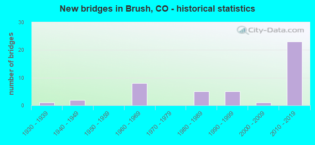
- New bridges - historical statistics
- 11930-1939
- 21940-1949
- 81960-1969
- 51980-1989
- 51990-1999
- 12000-2009
- 232010-2019


- Bridge Condition - Deck
- 9.4%Very good
- 53.1%Good
- 18.8%Satisfactory
- 15.6%Fair
- 3.1%Poor

- Bridge Condition - Superstructure
- 6.3%Very good
- 46.9%Good
- 21.9%Satisfactory
- 18.8%Fair
- 6.3%Poor

- Bridge Condition - Substructure
- 9.4%Very good
- 50.0%Good
- 18.8%Satisfactory
- 15.6%Fair
- 6.3%Poor

- Bridge Condition - Channel
- 35.0%Very good
- 45.0%Good
- 5.0%Satisfactory
- 15.0%Fair
Find on map >> Show street view
Structure Number: C-22-AY, Location: E EDGE OF BRUSH (Lat: 40.269506, Lng: -103.594539), Route carried "on" structure: Interstate 76A, Year Built: 1960, Status: Open, Structure Length: 18.55m (60.86ft), Average Daily Traffic: 6,000 (year 2020), Truck Traffic: 18%, Average Future Daily Traffic: 7,740 (year 2040), Design Load: HS 20, Features Intersected: BNSF RR, BEAVER CREEK, Facility Carried by Structure: I 76 ML WBND
Minimum Vertical Clearance: 30+ m (98+ ft), Kilometerpoint: 146.542, Lanes on structure: 2, Base Highway Network: Yes, Owner: State Highway Agency, Approaching Roadway Width: 11.6m (38.1ft), Skew: 19 degrees, Material/Design: Prestressed concrete, Design/Construction: Stringer/Multi-beam, Number Of Spans In Main Unit: 8, Length of Maximum Span: 23.9m (78.4ft), Curb or Sidewalk Widths: Left: 0.5m (1.6ft), Right: 0.5m (1.6ft), Curb-To-Curb Width: 9.1m (29.9ft), Out-to-Out Width: 10.4m (34.1ft)
Condition: Deck: Fair, Superstructure: Poor, Substructure: Fair, Channel: Very good, Operating Rating: 34.3 metric tons, Method Used To Determine Operating Rating: Load Factor (LF), Inventory Rating: 20.9 metric tons, Method Used To Determine Inventory Rating: Load Factor (LF), Structural Evaluation: Meets minimum limits, Deck Geometry: Meets minimum limits, Underclear: Better than present minimum criteria, Waterway Adequacy: Superior to present desirable criteria, Approach Roadway Alignment: Equal to present desirable criteria, Designated Inspection Frequency: Every 12 months, Inspection Date: June 2021, Deck Structure Type: Concrete Cast-file-Place, Wearing Surface/Protective System: Wearing Surface: Bituminous, Membrane: Preformed Fabric
Find on map >> Show street view
Structure Number: C-22-AZ, Location: 1.5 MI NE OF JCT SH 71 (Lat: 40.269231, Lng: -103.594900), Route carried "on" structure: Interstate 76A, Year Built: 1960, Status: Open, Structure Length: 18.44m (60.50ft), Average Daily Traffic: 6,000 (year 2020), Truck Traffic: 18%, Average Future Daily Traffic: 7,740 (year 2040), Design Load: HS 20, Features Intersected: BNSF RR, BEAVER CREEK, Facility Carried by Structure: I 76 ML EBND
Minimum Vertical Clearance: 30+ m (98+ ft), Kilometerpoint: 146.507, Lanes on structure: 2, Base Highway Network: Yes, Owner: State Highway Agency, Approaching Roadway Width: 11.6m (38.1ft), Skew: 15 degrees, Material/Design: Prestressed concrete, Design/Construction: Stringer/Multi-beam, Number Of Spans In Main Unit: 8, Number Of Approach Spans: 2, Length of Maximum Span: 23.9m (78.4ft), Curb or Sidewalk Widths: Left: 0.5m (1.6ft), Right: 0.5m (1.6ft), Curb-To-Curb Width: 9.1m (29.9ft), Out-to-Out Width: 10.4m (34.1ft)
Condition: Deck: Fair, Superstructure: Fair, Substructure: Fair, Channel: Good, Operating Rating: 51.3 metric tons, Method Used To Determine Operating Rating: Load Factor (LF), Inventory Rating: 31.5 metric tons, Method Used To Determine Inventory Rating: Load Factor (LF), Structural Evaluation: Somewhat better than minimum adequacy, Deck Geometry: Meets minimum limits, Underclear: Better than present minimum criteria, Waterway Adequacy: Superior to present desirable criteria, Approach Roadway Alignment: Equal to present desirable criteria, Designated Inspection Frequency: Every 24 months, Inspection Date: June 2021, Deck Structure Type: Concrete Cast-file-Place, Wearing Surface/Protective System: Wearing Surface: Bituminous
Find on map >> Show street view
Structure Number: C-22-B, Location: 6.1 MI E OF JCT SH 52 (Lat: 40.254322, Lng: -103.687244), Route carried "on" structure: US 34B, Year Built: 1940, Year Reconstructed: 1958, Status: Open, Structure Length: 1.35m (4.43ft), Average Daily Traffic: 4,300 (year 2020), Truck Traffic: 11%, Average Future Daily Traffic: 4,988 (year 2040), Design Load: HS 20, Features Intersected: UPPR PLATTE,BEAVER CANAL, Facility Carried by Structure: US 34 ML
Minimum Vertical Clearance: 30+ m (98+ ft), Kilometerpoint: 16.966, Lanes on structure: 2, Base Highway Network: Yes, Owner: State Highway Agency, Approaching Roadway Width: 12.2m (40.0ft), Skew: 4 degrees, Material/Design: Steel, Design/Construction: Stringer/Multi-beam, Number Of Spans In Main Unit: 1, Length of Maximum Span: 12.0m (39.4ft), Curb-To-Curb Width: 13.4m (44.0ft), Out-to-Out Width: 14.6m (47.9ft)
Condition: Deck: Satisfactory, Superstructure: Satisfactory, Substructure: Satisfactory, Channel: Very good, Operating Rating: 37.2 metric tons, Method Used To Determine Operating Rating: Load Factor (LF), Inventory Rating: 22.2 metric tons, Method Used To Determine Inventory Rating: Load Factor (LF), Structural Evaluation: Somewhat better than minimum adequacy, Deck Geometry: Better than present minimum criteria, Waterway Adequacy: Equal to present desirable criteria, Approach Roadway Alignment: Equal to present desirable criteria, Designated Inspection Frequency: Every 24 months, Inspection Date: November 2021, Deck Structure Type: Concrete Cast-file-Place, Wearing Surface/Protective System: Wearing Surface: Bituminous
Find on map >> Show street view
Structure Number: C-22-BA, Location: 4 MI S.W. OF BRUSH (Lat: 40.267797, Lng: -103.697283), Route carried "on" structure: Interstate 76A, Year Built: 2014, Status: Open, Structure Length: 3.99m (13.09ft), Average Daily Traffic: 8,000 (year 2020), Truck Traffic: 16%, Average Future Daily Traffic: 10,800 (year 2040), Design Load: HL 93, Features Intersected: COUNTY ROAD 24, Facility Carried by Structure: I 76 ML EBND
Minimum Vertical Clearance: 30+ m (98+ ft), Kilometerpoint: 137.790, Lanes on structure: 2, Lanes under structure: 2, Base Highway Network: Yes, Owner: State Highway Agency, Approaching Roadway Width: 12.5m (41.0ft), Skew: 10 degrees, Material/Design: Prestressed concrete, Design/Construction: Stringer/Multi-beam, Number Of Spans In Main Unit: 1, Length of Maximum Span: 38.4m (126.0ft), Curb-To-Curb Width: 11.6m (38.1ft), Out-to-Out Width: 12.5m (41.0ft)
Condition: Deck: Very good, Superstructure: Good, Substructure: Very good, Operating Rating: 48.6 metric tons, Method Used To Determine Operating Rating: Load and Resistance Factor Rating (LRFR) rating reported by rating factor(RF) method using HL-93 loadings, Inventory Rating: 38.9 metric tons, Method Used To Determine Inventory Rating: Load and Resistance Factor Rating (LRFR) rating reported by rating factor(RF) method using HL-93 loadings, Structural Evaluation: Better than present minimum criteria, Deck Geometry: Equal to present minimum criteria, Underclear: Better than present minimum criteria, Approach Roadway Alignment: Equal to present desirable criteria, Length Of Structure Improvement: 3.41m (11.19ft), Designated Inspection Frequency: Every 24 months, Inspection Date: June 2021, Bridge Improvement Cost: $193,000, Roadway Improvement Cost: $19,000, Total Project Cost: $290,000, Deck Structure Type: Concrete Precast Panels, Wearing Surface/Protective System: Wearing Surface: Bituminous, Membrane: Built-up, Deck Protection: Epoxy Coated Reinforcing
Find on map >> Show street view
Structure Number: C-22-BB, Location: 5 MI E OF FT MORGAN (Lat: 40.268050, Lng: -103.697281), Route carried "on" structure: Interstate 76A, Year Built: 2013, Status: Open, Structure Length: 3.99m (13.09ft), Average Daily Traffic: 8,000 (year 2020), Truck Traffic: 16%, Average Future Daily Traffic: 10,800 (year 2040), Design Load: HL 93, Features Intersected: COUNTY ROAD 24, Facility Carried by Structure: I 76 ML WBND
Minimum Vertical Clearance: 30+ m (98+ ft), Kilometerpoint: 137.792, Lanes on structure: 2, Lanes under structure: 2, Base Highway Network: Yes, Owner: State Highway Agency, Approaching Roadway Width: 12.5m (41.0ft), Skew: 10 degrees, Material/Design: Prestressed concrete, Design/Construction: Stringer/Multi-beam, Number Of Spans In Main Unit: 1, Length of Maximum Span: 38.4m (126.0ft), Curb-To-Curb Width: 11.6m (38.1ft), Out-to-Out Width: 12.5m (41.0ft)
Condition: Deck: Good, Superstructure: Good, Substructure: Good, Operating Rating: 48.6 metric tons, Method Used To Determine Operating Rating: Load and Resistance Factor Rating (LRFR) rating reported by rating factor(RF) method using HL-93 loadings, Inventory Rating: 38.9 metric tons, Method Used To Determine Inventory Rating: Load and Resistance Factor Rating (LRFR) rating reported by rating factor(RF) method using HL-93 loadings, Structural Evaluation: Better than present minimum criteria, Deck Geometry: Equal to present minimum criteria, Underclear: Better than present minimum criteria, Approach Roadway Alignment: Equal to present desirable criteria, Length Of Structure Improvement: 3.41m (11.19ft), Designated Inspection Frequency: Every 24 months, Inspection Date: June 2021, Bridge Improvement Cost: $194,000, Roadway Improvement Cost: $19,000, Total Project Cost: $291,000, Deck Structure Type: Concrete Precast Panels, Wearing Surface/Protective System: Wearing Surface: Bituminous, Membrane: Built-up, Deck Protection: Epoxy Coated Reinforcing
Find on map >> Show street view
Structure Number: C-22-BC, Location: 4 MI E of Ft Morgan (Lat: 40.267711, Lng: -103.706319), Route carried "on" structure: Interstate 76A, Year Built: 2014, Status: Open, Structure Length: 4.10m (13.45ft), Average Daily Traffic: 8,000 (year 2020), Truck Traffic: 16%, Average Future Daily Traffic: 10,800 (year 2040), Design Load: HL 93, Features Intersected: BADGER CREEK, Facility Carried by Structure: I76 ML EBND
Minimum Vertical Clearance: 30+ m (98+ ft), Kilometerpoint: 137.020, Lanes on structure: 2, Base Highway Network: Yes, Owner: State Highway Agency, Approaching Roadway Width: 14.9m (48.9ft), Skew: 10 degrees, Material/Design: Prestressed concrete, Design/Construction: Stringer/Multi-beam, Number Of Spans In Main Unit: 1, Length of Maximum Span: 39.5m (129.6ft), Curb-To-Curb Width: 14.0m (45.9ft), Out-to-Out Width: 14.9m (48.9ft)
Condition: Deck: Very good, Superstructure: Good, Substructure: Good, Channel: Very good, Operating Rating: 55.1 metric tons, Method Used To Determine Operating Rating: Load and Resistance Factor Rating (LRFR) rating reported by rating factor(RF) method using HL-93 loadings, Inventory Rating: 42.1 metric tons, Method Used To Determine Inventory Rating: Load and Resistance Factor Rating (LRFR) rating reported by rating factor(RF) method using HL-93 loadings, Structural Evaluation: Better than present minimum criteria, Deck Geometry: Superior to present desirable criteria, Waterway Adequacy: Equal to present desirable criteria, Approach Roadway Alignment: Equal to present desirable criteria, Designated Inspection Frequency: Every 24 months, Inspection Date: June 2021, Deck Structure Type: Concrete Precast Panels, Wearing Surface/Protective System: Wearing Surface: Bituminous, Membrane: Built-up, Deck Protection: Epoxy Coated Reinforcing
Find on map >> Show street view
Structure Number: C-22-BD, Location: 4 MI EA OF FT. MORGAN (Lat: 40.267981, Lng: -103.706378), Route carried "on" structure: Interstate 76A, Year Built: 2013, Status: Open, Structure Length: 4.10m (13.45ft), Average Daily Traffic: 8,000 (year 2020), Truck Traffic: 16%, Average Future Daily Traffic: 10,800 (year 2040), Design Load: HL 93, Features Intersected: BADGER CREEK, Facility Carried by Structure: I 76 ML WBND
Minimum Vertical Clearance: 30+ m (98+ ft), Kilometerpoint: 137.015, Lanes on structure: 3, Base Highway Network: Yes, Owner: State Highway Agency, Approaching Roadway Width: 14.9m (48.9ft), Skew: 10 degrees, Material/Design: Prestressed concrete, Design/Construction: Stringer/Multi-beam, Number Of Spans In Main Unit: 1, Length of Maximum Span: 39.5m (129.6ft), Curb-To-Curb Width: 14.0m (45.9ft), Out-to-Out Width: 14.9m (48.9ft)
Condition: Deck: Good, Superstructure: Good, Substructure: Good, Channel: Very good, Operating Rating: 55.1 metric tons, Method Used To Determine Operating Rating: Load and Resistance Factor Rating (LRFR) rating reported by rating factor(RF) method using HL-93 loadings, Inventory Rating: 42.1 metric tons, Method Used To Determine Inventory Rating: Load and Resistance Factor Rating (LRFR) rating reported by rating factor(RF) method using HL-93 loadings, Structural Evaluation: Better than present minimum criteria, Deck Geometry: Meets minimum limits, Approach Roadway Alignment: Equal to present desirable criteria, Length Of Structure Improvement: 3.41m (11.19ft), Designated Inspection Frequency: Every 24 months, Inspection Date: June 2021, Bridge Improvement Cost: $193,000, Roadway Improvement Cost: $19,000, Total Project Cost: $290,000, Deck Structure Type: Concrete Precast Panels, Wearing Surface/Protective System: Wearing Surface: Bituminous, Membrane: Built-up, Deck Protection: Epoxy Coated Reinforcing
Find on map >> Show street view
Structure Number: C-22-BE, Location: AT JCT US 6 + 34B-BRUSH (Lat: 40.271642, Lng: -103.584358), Route carried "on" structure: Interstate 76A, Year Built: 1964, Status: Open, Structure Length: 5.57m (18.27ft), Average Daily Traffic: 6,000 (year 2020), Truck Traffic: 18%, Average Future Daily Traffic: 7,740 (year 2040), Design Load: HS 20, Features Intersected: US 6 ML, Facility Carried by Structure: I 76 ML WBND
Minimum Vertical Clearance: 30+ m (98+ ft), Kilometerpoint: 147.443, Lanes on structure: 3, Lanes under structure: 4, Base Highway Network: Yes, Owner: State Highway Agency, Approaching Roadway Width: 13.4m (44.0ft), Skew: 14 degrees, Material/Design: Prestressed concrete, Design/Construction: Stringer/Multi-beam, Number Of Spans In Main Unit: 3, Length of Maximum Span: 25.0m (82.0ft), Curb or Sidewalk Widths: Left: 0.6m (2.0ft), Right: 0.6m (2.0ft), Curb-To-Curb Width: 12.8m (42.0ft), Out-to-Out Width: 14.0m (45.9ft)
Condition: Deck: Fair, Superstructure: Satisfactory, Substructure: Satisfactory, Operating Rating: 51.7 metric tons, Method Used To Determine Operating Rating: Load Factor (LF), Inventory Rating: 30.0 metric tons, Method Used To Determine Inventory Rating: Load Factor (LF), Structural Evaluation: Equal to present minimum criteria, Deck Geometry: High priority of replacement, Underclear: Meets minimum limits, Approach Roadway Alignment: Equal to present desirable criteria, Designated Inspection Frequency: Every 24 months, Inspection Date: June 2021, Deck Structure Type: Concrete Cast-file-Place, Wearing Surface/Protective System: Wearing Surface: Bituminous, Membrane: Built-up
Find on map >> Show street view
Structure Number: C-22-BF, Location: 1.7 MI NE OF JCT SH 71, B (Lat: 40.270206, Lng: -103.588683), Route carried "on" structure: Interstate 76A, Year Built: 1961, Status: Open, Structure Length: 0.64m (2.10ft), Average Daily Traffic: 12,000 (year 2020), Truck Traffic: 18%, Average Future Daily Traffic: 15,480 (year 2040), Design Load: H 20, Features Intersected: BIG BEAVER CREEK, Facility Carried by Structure: I 76 ML
Minimum Vertical Clearance: 30+ m (98+ ft), Kilometerpoint: 147.046, Lanes on structure: 4, Base Highway Network: Yes, Owner: State Highway Agency, Approaching Roadway Width: 23.2m (76.1ft), Skew: 20 degrees, Material/Design: Concrete, Design/Construction: Culvert, Number Of Spans In Main Unit: 2, Length of Maximum Span: 3.0m (9.8ft), Out-to-Out Width: 76.2m (250.0ft)
Condition: Channel: Good, Culverts: Good, Operating Rating: 89.8 metric tons, Method Used To Determine Operating Rating: Field evaluation and documented engineering judgment, Inventory Rating: 89.8 metric tons, Method Used To Determine Inventory Rating: Field evaluation and documented engineering judgment, Structural Evaluation: Better than present minimum criteria, Waterway Adequacy: Superior to present desirable criteria, Approach Roadway Alignment: Equal to present desirable criteria, Designated Inspection Frequency: Every 24 months, Inspection Date: June 2021
Find on map >> Show street view
Structure Number: C-22-BG, Location: AT JCT. US 6 & 34B-BR (Lat: 40.271319, Lng: -103.584525), Route carried "on" structure: Interstate 76A, Year Built: 1961, Status: Open, Structure Length: 5.49m (18.01ft), Average Daily Traffic: 6,000 (year 2020), Truck Traffic: 18%, Average Future Daily Traffic: 7,740 (year 2040), Design Load: HS 20, Features Intersected: US 34 SPUR, Facility Carried by Structure: I 76 ML EBND
Minimum Vertical Clearance: 30+ m (98+ ft), Kilometerpoint: 147.416, Lanes on structure: 3, Lanes under structure: 4, Base Highway Network: Yes, Owner: State Highway Agency, Approaching Roadway Width: 18.9m (62.0ft), Skew: 14 degrees, Material/Design: Prestressed concrete, Design/Construction: Stringer/Multi-beam, Number Of Spans In Main Unit: 3, Length of Maximum Span: 25.0m (82.0ft), Curb or Sidewalk Widths: Left: 0.5m (1.6ft), Right: 0.5m (1.6ft), Curb-To-Curb Width: 12.8m (42.0ft), Out-to-Out Width: 14.0m (45.9ft)
Condition: Deck: Poor, Superstructure: Fair, Substructure: Satisfactory, Operating Rating: 53.5 metric tons, Method Used To Determine Operating Rating: Load Factor (LF), Inventory Rating: 31.8 metric tons, Method Used To Determine Inventory Rating: Load Factor (LF), Structural Evaluation: Somewhat better than minimum adequacy, Deck Geometry: High priority of replacement, Underclear: High priority of corrective action, Approach Roadway Alignment: Equal to present desirable criteria, Length Of Structure Improvement: 5.49m (18.01ft), Designated Inspection Frequency: Every 24 months, Inspection Date: June 2021, Bridge Improvement Cost: $298,000, Roadway Improvement Cost: $30,000, Total Project Cost: $447,000, Deck Structure Type: Concrete Cast-file-Place, Wearing Surface/Protective System: Wearing Surface: Bituminous
Find on map >> Show street view
Structure Number: C-22-BR, Location: 0.4 MI NE OF JCT I-76 (Lat: 40.276664, Lng: -103.581431), Route carried "on" structure: US 6J, Year Built: 1987, Status: Open, Structure Length: 2.55m (8.37ft), Average Daily Traffic: 1,400 (year 2020), Truck Traffic: 11%, Average Future Daily Traffic: 2,044 (year 2040), Design Load: HS 20+Mod, Features Intersected: BEAVER CREEK, Facility Carried by Structure: US 6 ML
Minimum Vertical Clearance: 30+ m (98+ ft), Kilometerpoint: 0.600, Lanes on structure: 2, Owner: State Highway Agency, Approaching Roadway Width: 7.9m (25.9ft), Material/Design: Concrete continuous, Design/Construction: Frame, Number Of Spans In Main Unit: 2, Length of Maximum Span: 12.5m (41.0ft), Curb-To-Curb Width: 12.2m (40.0ft), Out-to-Out Width: 13.0m (42.7ft)
Condition: Deck: Good, Superstructure: Good, Substructure: Good, Channel: Good, Operating Rating: 81.6 metric tons, Method Used To Determine Operating Rating: Load Factor (LF), Inventory Rating: 59.0 metric tons, Method Used To Determine Inventory Rating: Load Factor (LF), Structural Evaluation: Better than present minimum criteria, Deck Geometry: Better than present minimum criteria, Waterway Adequacy: Equal to present desirable criteria, Approach Roadway Alignment: Equal to present desirable criteria, Designated Inspection Frequency: Every 24 months, Inspection Date: August 2021, Deck Structure Type: Concrete Cast-file-Place, Wearing Surface/Protective System: Wearing Surface: Bituminous, Membrane: Preformed Fabric, Deck Protection: Epoxy Coated Reinforcing
Find on map >> Show street view
Structure Number: C-22-BS, Location: E. EDGE OF BRUSH (Lat: 40.258603, Lng: -103.603053), Route carried "on" structure: US 34B, Year Built: 1991, Status: Open, Structure Length: 4.27m (14.01ft), Average Daily Traffic: 3,800 (year 2020), Truck Traffic: 20%, Average Future Daily Traffic: 4,712 (year 2040), Design Load: HS 20+Mod, Features Intersected: BEAVER CREEK, Facility Carried by Structure: US 34 ML
Minimum Vertical Clearance: 30+ m (98+ ft), Kilometerpoint: 24.192, Lanes on structure: 2, Base Highway Network: Yes, Owner: State Highway Agency, Approaching Roadway Width: 13.4m (44.0ft), Skew: 3 degrees, Material/Design: Concrete continuous, Design/Construction: Slab, Number Of Spans In Main Unit: 5, Length of Maximum Span: 8.7m (28.5ft), Curb-To-Curb Width: 13.4m (44.0ft), Out-to-Out Width: 14.2m (46.6ft)
Condition: Deck: Satisfactory, Superstructure: Satisfactory, Substructure: Good, Channel: Good, Inventory Rating: 62.4 metric tons, Method Used To Determine Inventory Rating: Load Factor (LF), Structural Evaluation: Equal to present minimum criteria, Deck Geometry: Better than present minimum criteria, Waterway Adequacy: Equal to present desirable criteria, Approach Roadway Alignment: Equal to present desirable criteria, Designated Inspection Frequency: Every 48 months, Inspection Date: August 2019, Deck Structure Type: Concrete Cast-file-Place, Wearing Surface/Protective System: Wearing Surface: Bituminous, Membrane: Preformed Fabric, Deck Protection: Epoxy Coated Reinforcing
Find on map >> Show street view
Structure Number: C-22-BW, Location: _ (Lat: 40.268169, Lng: -103.678589), Route carried "on" structure: Interstate 76A, Year Built: 2013, Status: Open, Structure Length: 3.06m (10.04ft), Average Daily Traffic: 8,000 (year 2020), Truck Traffic: 17%, Average Future Daily Traffic: 10,880 (year 2040), Design Load: HL 93, Features Intersected: COUNTY ROAD 25, Facility Carried by Structure: I76 ML WBND
Minimum Vertical Clearance: 30+ m (98+ ft), Kilometerpoint: 139.385, Lanes on structure: 2, Lanes under structure: 2, Base Highway Network: Yes, Owner: State Highway Agency, Approaching Roadway Width: 12.5m (41.0ft), Skew: 10 degrees, Material/Design: Prestressed concrete, Design/Construction: Stringer/Multi-beam, Number Of Spans In Main Unit: 1, Length of Maximum Span: 29.9m (98.1ft), Curb-To-Curb Width: 11.6m (38.1ft), Out-to-Out Width: 12.5m (41.0ft)
Condition: Deck: Good, Superstructure: Good, Substructure: Good, Operating Rating: 48.6 metric tons, Method Used To Determine Operating Rating: Load and Resistance Factor Rating (LRFR) rating reported by rating factor(RF) method using HL-93 loadings, Inventory Rating: 35.6 metric tons, Method Used To Determine Inventory Rating: Load and Resistance Factor Rating (LRFR) rating reported by rating factor(RF) method using HL-93 loadings, Structural Evaluation: Better than present minimum criteria, Deck Geometry: Equal to present minimum criteria, Underclear: Better than present minimum criteria, Approach Roadway Alignment: Equal to present desirable criteria, Designated Inspection Frequency: Every 24 months, Inspection Date: June 2021, Deck Structure Type: Concrete Precast Panels, Wearing Surface/Protective System: Wearing Surface: Bituminous, Membrane: Built-up, Deck Protection: Epoxy Coated Reinforcing
Find on map >> Show street view
Structure Number: C-22-BX, Location: 6 MILES E OF FT MORGAN (Lat: 40.267933, Lng: -103.678625), Route carried "on" structure: Interstate 76A, Year Built: 2013, Status: Open, Structure Length: 3.06m (10.04ft), Average Daily Traffic: 8,000 (year 2020), Truck Traffic: 17%, Average Future Daily Traffic: 10,880 (year 2040), Design Load: HL 93, Features Intersected: COUNTY ROAD 25, Facility Carried by Structure: I 76 ML EBND
Minimum Vertical Clearance: 30+ m (98+ ft), Kilometerpoint: 139.380, Lanes on structure: 2, Lanes under structure: 2, Base Highway Network: Yes, Owner: State Highway Agency, Approaching Roadway Width: 12.5m (41.0ft), Skew: 10 degrees, Material/Design: Prestressed concrete, Design/Construction: Stringer/Multi-beam, Number Of Spans In Main Unit: 1, Length of Maximum Span: 29.9m (98.1ft), Curb-To-Curb Width: 11.6m (38.1ft), Out-to-Out Width: 12.5m (41.0ft)
Condition: Deck: Good, Superstructure: Very good, Substructure: Very good, Operating Rating: 48.6 metric tons, Method Used To Determine Operating Rating: Load and Resistance Factor Rating (LRFR) rating reported by rating factor(RF) method using HL-93 loadings, Inventory Rating: 35.6 metric tons, Method Used To Determine Inventory Rating: Load and Resistance Factor Rating (LRFR) rating reported by rating factor(RF) method using HL-93 loadings, Structural Evaluation: Equal to present desirable criteria, Deck Geometry: Somewhat better than minimum adequacy, Underclear: Superior to present desirable criteria, Approach Roadway Alignment: Equal to present desirable criteria, Designated Inspection Frequency: Every 24 months, Inspection Date: June 2021, Deck Structure Type: Concrete Precast Panels, Wearing Surface/Protective System: Wearing Surface: Bituminous, Membrane: Built-up, Deck Protection: Epoxy Coated Reinforcing
Find on map >> Show street view
Structure Number: C-22-BY, Location: 7 MI E of Ft Morgan (Lat: 40.268383, Lng: -103.659625), Route carried "on" structure: Interstate 76A, Year Built: 2014, Status: Open, Structure Length: 3.06m (10.04ft), Average Daily Traffic: 8,000 (year 2020), Truck Traffic: 17%, Average Future Daily Traffic: 10,880 (year 2040), Design Load: HL 93, Features Intersected: COUNTY ROAD 26, Facility Carried by Structure: I 76 ML WBND
Minimum Vertical Clearance: 30+ m (98+ ft), Kilometerpoint: 141.003, Lanes on structure: 2, Lanes under structure: 2, Base Highway Network: Yes, Owner: State Highway Agency, Approaching Roadway Width: 12.5m (41.0ft), Skew: 10 degrees, Material/Design: Prestressed concrete, Design/Construction: Stringer/Multi-beam, Number Of Spans In Main Unit: 1, Length of Maximum Span: 29.1m (95.5ft), Curb-To-Curb Width: 11.6m (38.1ft), Out-to-Out Width: 12.5m (41.0ft)
Condition: Deck: Good, Superstructure: Good, Substructure: Good, Operating Rating: 48.6 metric tons, Method Used To Determine Operating Rating: Load and Resistance Factor Rating (LRFR) rating reported by rating factor(RF) method using HL-93 loadings, Inventory Rating: 35.6 metric tons, Method Used To Determine Inventory Rating: Load and Resistance Factor Rating (LRFR) rating reported by rating factor(RF) method using HL-93 loadings, Structural Evaluation: Better than present minimum criteria, Deck Geometry: Equal to present minimum criteria, Underclear: Superior to present desirable criteria, Approach Roadway Alignment: Equal to present desirable criteria, Designated Inspection Frequency: Every 24 months, Inspection Date: June 2021, Deck Structure Type: Concrete Precast Panels, Wearing Surface/Protective System: Wearing Surface: Monolithic Concrete, Membrane: Built-up, Deck Protection: Epoxy Coated Reinforcing
Find on map >> Show street view
Structure Number: C-22-BZ, Location: 7 MILES E OF FT MORGAN (Lat: 40.268136, Lng: -103.659622), Route carried "on" structure: Interstate 76A, Year Built: 2013, Status: Open, Structure Length: 3.06m (10.04ft), Average Daily Traffic: 8,000 (year 2020), Truck Traffic: 17%, Average Future Daily Traffic: 10,880 (year 2040), Design Load: HL 93, Features Intersected: COUNTY ROAD 26, Facility Carried by Structure: I 76 ML EBND
Minimum Vertical Clearance: 30+ m (98+ ft), Kilometerpoint: 141.003, Lanes on structure: 2, Lanes under structure: 2, Base Highway Network: Yes, Owner: State Highway Agency, Approaching Roadway Width: 12.5m (41.0ft), Skew: 10 degrees, Material/Design: Prestressed concrete, Design/Construction: Stringer/Multi-beam, Number Of Spans In Main Unit: 1, Length of Maximum Span: 29.1m (95.5ft), Curb-To-Curb Width: 11.6m (38.1ft), Out-to-Out Width: 12.5m (41.0ft)
Condition: Deck: Good, Superstructure: Very good, Substructure: Very good, Operating Rating: 48.6 metric tons, Method Used To Determine Operating Rating: Load and Resistance Factor Rating (LRFR) rating reported by rating factor(RF) method using HL-93 loadings, Inventory Rating: 35.6 metric tons, Method Used To Determine Inventory Rating: Load and Resistance Factor Rating (LRFR) rating reported by rating factor(RF) method using HL-93 loadings, Structural Evaluation: Equal to present desirable criteria, Deck Geometry: Equal to present minimum criteria, Underclear: Superior to present desirable criteria, Approach Roadway Alignment: Equal to present desirable criteria, Designated Inspection Frequency: Every 24 months, Inspection Date: June 2021, Deck Structure Type: Concrete Precast Panels, Wearing Surface/Protective System: Wearing Surface: Bituminous, Membrane: Built-up, Deck Protection: Epoxy Coated Reinforcing
Find on map >> Show street view
Structure Number: C-22-CA, Location: JUST W. OF BRUSH EXIT (Lat: 40.268300, Lng: -103.640997), Route carried "on" structure: Interstate 76A, Year Built: 2013, Status: Open, Structure Length: 3.99m (13.09ft), Average Daily Traffic: 8,000 (year 2020), Truck Traffic: 17%, Average Future Daily Traffic: 10,880 (year 2040), Design Load: HL 93, Features Intersected: HOSPITAL ROAD, Facility Carried by Structure: I 76 ML EBND
Minimum Vertical Clearance: 30+ m (98+ ft), Kilometerpoint: 142.588, Lanes on structure: 2, Lanes under structure: 3, Base Highway Network: Yes, Owner: State Highway Agency, Approaching Roadway Width: 11.6m (38.1ft), Skew: 10 degrees, Material/Design: Prestressed concrete, Design/Construction: Stringer/Multi-beam, Number Of Spans In Main Unit: 1, Length of Maximum Span: 38.4m (126.0ft), Curb-To-Curb Width: 11.6m (38.1ft), Out-to-Out Width: 12.5m (41.0ft)
Condition: Deck: Good, Superstructure: Good, Substructure: Good, Operating Rating: 48.6 metric tons, Method Used To Determine Operating Rating: Load and Resistance Factor Rating (LRFR) rating reported by rating factor(RF) method using HL-93 loadings, Inventory Rating: 38.9 metric tons, Method Used To Determine Inventory Rating: Load and Resistance Factor Rating (LRFR) rating reported by rating factor(RF) method using HL-93 loadings, Structural Evaluation: Better than present minimum criteria, Deck Geometry: Equal to present minimum criteria, Underclear: Better than present minimum criteria, Approach Roadway Alignment: Equal to present desirable criteria, Designated Inspection Frequency: Every 24 months, Inspection Date: June 2021, Deck Structure Type: Concrete Precast Panels, Wearing Surface/Protective System: Wearing Surface: Bituminous, Membrane: Built-up, Deck Protection: Epoxy Coated Reinforcing
Find on map >> Show street view
Structure Number: C-22-CB, Location: 1 MI SW OF JCT SH 71 (Lat: 40.268550, Lng: -103.641000), Route carried "on" structure: Interstate 76A, Year Built: 2013, Status: Open, Structure Length: 3.99m (13.09ft), Average Daily Traffic: 8,000 (year 2020), Truck Traffic: 17%, Average Future Daily Traffic: 10,880 (year 2040), Design Load: HL 93, Features Intersected: HOSPITAL RD/CR 27, Facility Carried by Structure: I 76 ML WBND
Minimum Vertical Clearance: 30+ m (98+ ft), Kilometerpoint: 142.588, Lanes on structure: 2, Lanes under structure: 3, Base Highway Network: Yes, Owner: State Highway Agency, Approaching Roadway Width: 12.5m (41.0ft), Skew: 10 degrees, Material/Design: Prestressed concrete, Design/Construction: Stringer/Multi-beam, Number Of Spans In Main Unit: 1, Length of Maximum Span: 38.4m (126.0ft), Curb-To-Curb Width: 11.6m (38.1ft), Out-to-Out Width: 12.5m (41.0ft)
Condition: Deck: Very good, Superstructure: Good, Substructure: Good, Operating Rating: 48.6 metric tons, Method Used To Determine Operating Rating: Load and Resistance Factor Rating (LRFR) rating reported by rating factor(RF) method using HL-93 loadings, Inventory Rating: 38.9 metric tons, Method Used To Determine Inventory Rating: Load and Resistance Factor Rating (LRFR) rating reported by rating factor(RF) method using HL-93 loadings, Structural Evaluation: Better than present minimum criteria, Deck Geometry: Equal to present minimum criteria, Underclear: Better than present minimum criteria, Approach Roadway Alignment: Equal to present desirable criteria, Designated Inspection Frequency: Every 24 months, Inspection Date: June 2021, Deck Structure Type: Concrete Precast Panels, Wearing Surface/Protective System: Wearing Surface: Bituminous, Membrane: Built-up, Deck Protection: Epoxy Coated Reinforcing
Find on map >> Show street view
Structure Number: C-22-CE, Location: IN BRUSH (Lat: 40.268281, Lng: -103.621636), Route carried "on" structure: State highway 71E, Year Built: 2015, Status: Open, Structure Length: 6.95m (22.80ft), Average Daily Traffic: 5,200 (year 2020), Truck Traffic: 6%, Average Future Daily Traffic: 5,928 (year 2040), Design Load: HL 93, Features Intersected: I 76 ML, Facility Carried by Structure: SH 71 ML
Minimum Vertical Clearance: 30+ m (98+ ft), Kilometerpoint: 1.432, Lanes on structure: 3, Lanes under structure: 4, Base Highway Network: Yes, Owner: State Highway Agency, Approaching Roadway Width: 13.7m (44.9ft), Material/Design: Prestressed concrete continuous, Design/Construction: Box Beam or Girders - Multiple, Number Of Spans In Main Unit: 2, Length of Maximum Span: 34.4m (112.9ft), Curb or Sidewalk Widths: Left: 1.5m (4.9ft), Right: 1.5m (4.9ft), Curb-To-Curb Width: 13.7m (44.9ft), Out-to-Out Width: 17.7m (58.1ft)
Condition: Deck: Good, Superstructure: Good, Substructure: Good, Operating Rating: 42.1 metric tons, Method Used To Determine Operating Rating: Load and Resistance Factor Rating (LRFR) rating reported by rating factor(RF) method using HL-93 loadings, Inventory Rating: 32.4 metric tons, Method Used To Determine Inventory Rating: Load and Resistance Factor Rating (LRFR) rating reported by rating factor(RF) method using HL-93 loadings, Structural Evaluation: Better than present minimum criteria, Deck Geometry: Somewhat better than minimum adequacy, Underclear: Superior to present desirable criteria, Approach Roadway Alignment: Equal to present desirable criteria, Length Of Structure Improvement: 8.02m (26.31ft), Designated Inspection Frequency: Every 24 months, Inspection Date: March 2021, Bridge Improvement Cost: $549,000, Roadway Improvement Cost: $55,000, Total Project Cost: $824,000, Deck Structure Type: Concrete Cast-file-Place, Wearing Surface/Protective System: Wearing Surface: Bituminous, Membrane: Built-up, Deck Protection: Epoxy Coated Reinforcing
Find on map >> Show street view
Structure Number: C-22-CF, Location: 1 MI NE OF JCT SH 71, BRU (Lat: 40.268756, Lng: -103.603372), Route carried "on" structure: Interstate 76A, Year Built: 2013, Status: Open, Structure Length: 3.99m (13.09ft), Average Daily Traffic: 6,000 (year 2020), Truck Traffic: 18%, Average Future Daily Traffic: 7,740 (year 2040), Design Load: HL 93, Features Intersected: COUNTY ROAD 29, Facility Carried by Structure: I 76 ML EBND
Minimum Vertical Clearance: 30+ m (98+ ft), Kilometerpoint: 145.784, Lanes on structure: 2, Lanes under structure: 2, Base Highway Network: Yes, Owner: State Highway Agency, Approaching Roadway Width: 12.5m (41.0ft), Skew: 10 degrees, Material/Design: Prestressed concrete, Design/Construction: Stringer/Multi-beam, Number Of Spans In Main Unit: 1, Length of Maximum Span: 38.4m (126.0ft), Curb-To-Curb Width: 11.6m (38.1ft), Out-to-Out Width: 12.5m (41.0ft)
Condition: Deck: Good, Superstructure: Good, Substructure: Good, Operating Rating: 48.6 metric tons, Method Used To Determine Operating Rating: Load and Resistance Factor Rating (LRFR) rating reported by rating factor(RF) method using HL-93 loadings, Inventory Rating: 38.9 metric tons, Method Used To Determine Inventory Rating: Load and Resistance Factor Rating (LRFR) rating reported by rating factor(RF) method using HL-93 loadings, Structural Evaluation: Better than present minimum criteria, Deck Geometry: Equal to present minimum criteria, Underclear: Superior to present desirable criteria, Approach Roadway Alignment: Equal to present desirable criteria, Designated Inspection Frequency: Every 24 months, Inspection Date: June 2021, Deck Structure Type: Concrete Precast Panels, Wearing Surface/Protective System: Wearing Surface: Bituminous, Membrane: Built-up, Deck Protection: Epoxy Coated Reinforcing
Find on map >> Show street view
Structure Number: C-22-CG, Location: 1 MI NE OF SH 71, BRUSH (Lat: 40.269000, Lng: -103.603372), Route carried "on" structure: Interstate 76A, Year Built: 2013, Status: Open, Structure Length: 3.99m (13.09ft), Average Daily Traffic: 6,000 (year 2020), Truck Traffic: 18%, Average Future Daily Traffic: 7,740 (year 2040), Design Load: HL 93, Features Intersected: COUNTY ROAD 29, Facility Carried by Structure: I 76 ML WBND
Minimum Vertical Clearance: 30+ m (98+ ft), Kilometerpoint: 145.786, Lanes on structure: 2, Lanes under structure: 2, Base Highway Network: Yes, Owner: State Highway Agency, Approaching Roadway Width: 12.5m (41.0ft), Skew: 10 degrees, Material/Design: Prestressed concrete, Design/Construction: Stringer/Multi-beam, Number Of Spans In Main Unit: 1, Length of Maximum Span: 38.4m (126.0ft), Curb-To-Curb Width: 11.6m (38.1ft), Out-to-Out Width: 12.5m (41.0ft)
Condition: Deck: Good, Superstructure: Good, Substructure: Good, Operating Rating: 48.6 metric tons, Method Used To Determine Operating Rating: Load and Resistance Factor Rating (LRFR) rating reported by rating factor(RF) method using HL-93 loadings, Inventory Rating: 38.9 metric tons, Method Used To Determine Inventory Rating: Load and Resistance Factor Rating (LRFR) rating reported by rating factor(RF) method using HL-93 loadings, Structural Evaluation: Better than present minimum criteria, Deck Geometry: Equal to present minimum criteria, Underclear: Superior to present desirable criteria, Approach Roadway Alignment: Equal to present desirable criteria, Designated Inspection Frequency: Every 24 months, Inspection Date: June 2021, Deck Structure Type: Concrete Precast Panels, Wearing Surface/Protective System: Wearing Surface: Bituminous, Membrane: Built-up, Deck Protection: Epoxy Coated Reinforcing
Find on map >> Show street view
Structure Number: C-22-K, Location: 1.2 MI NE OF JCT I-76 (Lat: 40.285306, Lng: -103.572822), Route carried "on" structure: US 6J, Year Built: 1932, Status: Temporarily open, Structure Length: 1.77m (5.81ft), Average Daily Traffic: 1,400 (year 2020), Truck Traffic: 11%, Average Future Daily Traffic: 2,044 (year 2040), Design Load: H 15, Features Intersected: UPRR PLATTE,BEAVER CANAL, Facility Carried by Structure: US 6 ML
Minimum Vertical Clearance: 30+ m (98+ ft), Kilometerpoint: 1.823, Lanes on structure: 2, Owner: State Highway Agency, Approaching Roadway Width: 7.3m (24.0ft), Material/Design: Wood or Timber, Design/Construction: Stringer/Multi-beam, Number Of Spans In Main Unit: 3, Length of Maximum Span: 5.8m (19.0ft), Curb-To-Curb Width: 7.6m (24.9ft), Out-to-Out Width: 7.9m (25.9ft)
Condition: Deck: Fair, Superstructure: Fair, Substructure: Poor, Channel: Very good, Operating Rating: 42.8 metric tons, Method Used To Determine Operating Rating: Allowable Stress (AS), Inventory Rating: 30.4 metric tons, Method Used To Determine Inventory Rating: Allowable Stress (AS), Structural Evaluation: Meets minimum limits, Deck Geometry: Meets minimum limits, Waterway Adequacy: Equal to present desirable criteria, Approach Roadway Alignment: Equal to present desirable criteria, Designated Inspection Frequency: Every 12 months, Inspection Date: July 2021, Deck Structure Type: Wood or Timber, Wearing Surface/Protective System: Wearing Surface: Bituminous
Find on map >> Show street view
Structure Number: MG24-0.0-U.5, Location: 150 Ft. N of Co Rd U.5 (Lat: 40.297861, Lng: -103.696694), Route carried "on" structure: County highway , Year Built: 1982, Status: Open, Structure Length: 1.58m (5.18ft), Average Daily Traffic: 978 (year 2021), Truck Traffic: 46%, Average Future Daily Traffic: 1,242 (year 2041), Design Load: HS 20, Features Intersected: Wildcat Creek, Facility Carried by Structure: County Road 24
Minimum Vertical Clearance: 30+ m (98+ ft), Kilometerpoint: 9.115, Lanes on structure: 2, Owner: County Highway Agency, Approaching Roadway Width: 7.3m (24.0ft), Material/Design: Steel, Design/Construction: Stringer/Multi-beam, Number Of Spans In Main Unit: 1, Length of Maximum Span: 14.8m (48.6ft), Curb-To-Curb Width: 8.5m (27.9ft), Out-to-Out Width: 8.5m (27.9ft)
Condition: Deck: Fair, Superstructure: Fair, Substructure: Fair, Channel: Fair, Operating Rating: 38.4 metric tons, Method Used To Determine Operating Rating: Load Factor (LF), Inventory Rating: 23.0 metric tons, Method Used To Determine Inventory Rating: Load Factor (LF), Structural Evaluation: Somewhat better than minimum adequacy, Deck Geometry: Somewhat better than minimum adequacy, Waterway Adequacy: Better than present minimum criteria, Approach Roadway Alignment: Equal to present desirable criteria, Designated Inspection Frequency: Every 24 months, Inspection Date: November 2020, Deck Structure Type: Corrugated Steel, Wearing Surface/Protective System: Wearing Surface: Bituminous
Find on map >> Show street view
Structure Number: MG24-0.4-T, Location: 0.4 Mi N of Co Rd T (Lat: 40.280750, Lng: -103.696750), Route carried "on" structure: County highway , Year Built: 1965, Status: Open, Structure Length: 1.14m (3.74ft), Average Daily Traffic: 1,597 (year 2021), Truck Traffic: 33%, Average Future Daily Traffic: 2,028 (year 2041), Design Load: HS 20, Features Intersected: Lower Platte Beaver Cnl, Facility Carried by Structure: County Road 24
Minimum Vertical Clearance: 30+ m (98+ ft), Kilometerpoint: 7.218, Lanes on structure: 2, Owner: County Highway Agency, Approaching Roadway Width: 7.0m (23.0ft), Skew: 1 degrees, Material/Design: Steel, Design/Construction: Stringer/Multi-beam, Number Of Spans In Main Unit: 1, Length of Maximum Span: 9.8m (32.2ft), Curb or Sidewalk Widths: Left: 0.2m (0.7ft), Right: 0.2m (0.7ft), Curb-To-Curb Width: 7.7m (25.3ft), Out-to-Out Width: 8.2m (26.9ft)
Condition: Deck: Good, Superstructure: Satisfactory, Substructure: Poor, Channel: Good, Operating Rating: 36.3 metric tons, Method Used To Determine Operating Rating: Load Factor (LF), Inventory Rating: 32.1 metric tons, Method Used To Determine Inventory Rating: Load Factor (LF), Structural Evaluation: Meets minimum limits, Deck Geometry: Meets minimum limits, Waterway Adequacy: Equal to present desirable criteria, Approach Roadway Alignment: Equal to present desirable criteria, Designated Inspection Frequency: Every 24 months, Inspection Date: November 2020, Deck Structure Type: Concrete Cast-file-Place, Wearing Surface/Protective System: Wearing Surface: Bituminous
Find on map >> Show street view
Structure Number: MG24-0.6-T-A, Location: 0.6 Mi N of Co Rd T (Lat: 40.283056, Lng: -103.696750), Route carried "on" structure: County highway , Year Built: 1992, Status: Open, Structure Length: 17.83m (58.50ft), Average Daily Traffic: 1,597 (year 2021), Truck Traffic: 33%, Average Future Daily Traffic: 2,028 (year 2041), Design Load: HS 20, Features Intersected: South Platte River, Facility Carried by Structure: County Road 24
Minimum Vertical Clearance: 30+ m (98+ ft), Kilometerpoint: 7.475, Lanes on structure: 2, Owner: County Highway Agency, Approaching Roadway Width: 8.2m (26.9ft), Skew: 2 degrees, Material/Design: Prestressed concrete continuous, Design/Construction: Tee Beam, Number Of Spans In Main Unit: 6, Length of Maximum Span: 28.7m (94.2ft), Curb-To-Curb Width: 10.3m (33.8ft), Out-to-Out Width: 11.1m (36.4ft)
Condition: Deck: Satisfactory, Superstructure: Good, Substructure: Good, Channel: Satisfactory, Operating Rating: 42.0 metric tons, Method Used To Determine Operating Rating: Load Factor (LF), Inventory Rating: 25.1 metric tons, Method Used To Determine Inventory Rating: Load Factor (LF), Structural Evaluation: Equal to present minimum criteria, Deck Geometry: Somewhat better than minimum adequacy, Waterway Adequacy: Equal to present desirable criteria, Approach Roadway Alignment: Equal to present desirable criteria, Designated Inspection Frequency: Every 24 months, Inspection Date: November 2020, Deck Structure Type: Other, Wearing Surface/Protective System: Wearing Surface: Bituminous, Deck Protection: Epoxy Coated Reinforcing
Find on map >> Show street view
Structure Number: MG24-0.8-T-A, Location: 0.8 Mi N of Co Rd T (Lat: 40.286917, Lng: -103.696750), Route carried "on" structure: County highway , Year Built: 1997, Status: Open, Structure Length: 1.71m (5.61ft), Average Daily Traffic: 1,597 (year 2021), Truck Traffic: 33%, Average Future Daily Traffic: 2,028 (year 2041), Design Load: HS 20, Features Intersected: Tremont Canal, Facility Carried by Structure: County Road 24
Minimum Vertical Clearance: 30+ m (98+ ft), Kilometerpoint: 7.904, Lanes on structure: 2, Owner: County Highway Agency, Approaching Roadway Width: 7.0m (23.0ft), Skew: 2 degrees, Material/Design: Prestressed concrete, Design/Construction: Box Beam or Girders - Multiple, Number Of Spans In Main Unit: 1, Length of Maximum Span: 15.8m (51.8ft), Curb-To-Curb Width: 9.4m (30.8ft), Out-to-Out Width: 10.2m (33.5ft)
Condition: Deck: Good, Superstructure: Good, Substructure: Fair, Channel: Fair, Operating Rating: 54.5 metric tons, Method Used To Determine Operating Rating: Load Factor (LF), Inventory Rating: 34.2 metric tons, Method Used To Determine Inventory Rating: Load Factor (LF), Structural Evaluation: Somewhat better than minimum adequacy, Deck Geometry: Somewhat better than minimum adequacy, Waterway Adequacy: Better than present minimum criteria, Approach Roadway Alignment: Equal to present desirable criteria, Designated Inspection Frequency: Every 24 months, Inspection Date: November 2020, Deck Structure Type: Other, Wearing Surface/Protective System: Wearing Surface: Bituminous, Membrane: Built-up, Deck Protection: Epoxy Coated Reinforcing
Find on map >> Show street view
Structure Number: MG25-0.1-R-A, Location: 0.1 Mi N of Co Rd R (Lat: 40.248694, Lng: -103.679889), Route carried "on" structure: County highway , Year Built: 1999, Status: Open, Structure Length: 1.28m (4.20ft), Average Daily Traffic: 187 (year 2021), Truck Traffic: 36%, Average Future Daily Traffic: 237 (year 2041), Design Load: HS 20, Features Intersected: Upper Platte Beaver Cnl, Facility Carried by Structure: County Road 25
Minimum Vertical Clearance: 30+ m (98+ ft), Kilometerpoint: 1.719, Lanes on structure: 2, Owner: County Highway Agency, Approaching Roadway Width: 7.6m (24.9ft), Skew: 5 degrees, Material/Design: Prestressed concrete, Design/Construction: Box Beam or Girders - Multiple, Number Of Spans In Main Unit: 1, Length of Maximum Span: 11.6m (38.1ft), Curb-To-Curb Width: 9.4m (30.8ft), Out-to-Out Width: 10.2m (33.5ft)
Condition: Deck: Good, Superstructure: Good, Substructure: Good, Channel: Good, Operating Rating: 77.1 metric tons, Method Used To Determine Operating Rating: Load Factor (LF), Inventory Rating: 45.4 metric tons, Method Used To Determine Inventory Rating: Load Factor (LF), Structural Evaluation: Better than present minimum criteria, Deck Geometry: Equal to present minimum criteria, Waterway Adequacy: Equal to present desirable criteria, Approach Roadway Alignment: Equal to present desirable criteria, Designated Inspection Frequency: Every 24 months, Inspection Date: November 2020, Deck Structure Type: Other, Wearing Surface/Protective System: Wearing Surface: Bituminous, Membrane: Preformed Fabric, Deck Protection: Epoxy Coated Reinforcing
Find on map >> Show street view
Structure Number: MG28-0.0-U.5, Location: Just North Co Rd U.5 (Lat: 40.298611, Lng: -103.621833), Route carried "on" structure: County highway , Year Built: 1940, Status: Open, Structure Length: 0.89m (2.92ft), Average Daily Traffic: 131 (year 2021), Truck Traffic: 24%, Average Future Daily Traffic: 166 (year 2041), Design Load: HS 20, Features Intersected: Lower Platte Beaver Cnl, Facility Carried by Structure: County Road 28
Minimum Vertical Clearance: 30+ m (98+ ft), Kilometerpoint: 1.047, Lanes on structure: 2, Owner: County Highway Agency, Approaching Roadway Width: 6.1m (20.0ft), Skew: 1 degrees, Material/Design: Wood or Timber, Design/Construction: Stringer/Multi-beam, Number Of Spans In Main Unit: 1, Length of Maximum Span: 7.9m (25.9ft), Curb-To-Curb Width: 6.1m (20.0ft), Out-to-Out Width: 6.2m (20.3ft)
Condition: Deck: Satisfactory, Superstructure: Poor, Substructure: Satisfactory, Channel: Good, Operating Rating: 31.2 metric tons, Method Used To Determine Operating Rating: Allowable Stress (AS), Inventory Rating: 19.4 metric tons, Method Used To Determine Inventory Rating: Allowable Stress (AS), Structural Evaluation: Meets minimum limits, Deck Geometry: Meets minimum limits, Waterway Adequacy: Equal to present desirable criteria, Approach Roadway Alignment: Equal to present minimum criteria, Length Of Structure Improvement: 1.56m (5.12ft), Designated Inspection Frequency: Every 24 months, Inspection Date: November 2020, Bridge Improvement Cost: $661,000, Roadway Improvement Cost: $66,000, Total Project Cost: $727,000 ( Estimate for 2018), Deck Structure Type: Concrete Cast-file-Place, Wearing Surface/Protective System: Wearing Surface: Gravel
Find on map >> Show street view
Structure Number: MG28.5-0.1-U.5A, Location: 0.1 Mi No of Co Rd U.5 (Lat: 40.299111, Lng: -103.612444), Route carried "on" structure: County highway , Year Built: 2004, Status: Open, Structure Length: 0.94m (3.08ft), Average Daily Traffic: 83 (year 2021), Truck Traffic: 31%, Average Future Daily Traffic: 105 (year 2041), Design Load: HS 20, Features Intersected: Lower Platte Beaver Cnl, Facility Carried by Structure: County Road 28
Minimum Vertical Clearance: 30+ m (98+ ft), Kilometerpoint: 0.882, Lanes on structure: 2, Owner: County Highway Agency, Approaching Roadway Width: 7.3m (24.0ft), Material/Design: Steel, Design/Construction: Stringer/Multi-beam, Number Of Spans In Main Unit: 1, Length of Maximum Span: 8.2m (26.9ft), Curb-To-Curb Width: 10.0m (32.8ft), Out-to-Out Width: 10.1m (33.1ft)
Condition: Deck: Good, Superstructure: Satisfactory, Substructure: Good, Channel: Very good, Operating Rating: 64.6 metric tons, Method Used To Determine Operating Rating: Load Factor (LF), Inventory Rating: 38.6 metric tons, Method Used To Determine Inventory Rating: Load Factor (LF), Structural Evaluation: Equal to present minimum criteria, Deck Geometry: Superior to present desirable criteria, Waterway Adequacy: Equal to present desirable criteria, Approach Roadway Alignment: Equal to present desirable criteria, Designated Inspection Frequency: Every 24 months, Inspection Date: November 2020, Deck Structure Type: Concrete Cast-file-Place, Wearing Surface/Protective System: Wearing Surface: Gravel, Deck Protection: Epoxy Coated Reinforcing
Find on map >> Show street view
Structure Number: MG29-0.2-S34-A, Location: 0.2 Mi North of US Hwy 34 (Lat: 40.261750, Lng: -103.603250), Route carried "on" structure: County highway , Year Built: 1985, Status: Open, Structure Length: 3.51m (11.52ft), Average Daily Traffic: 1,566 (year 2021), Truck Traffic: 19%, Average Future Daily Traffic: 1,989 (year 2041), Design Load: HS 20, Features Intersected: Beaver Creek, Facility Carried by Structure: County Road 29
Minimum Vertical Clearance: 30+ m (98+ ft), Kilometerpoint: 0.338, Lanes on structure: 2, Owner: County Highway Agency, Approaching Roadway Width: 6.1m (20.0ft), Material/Design: Steel, Design/Construction: Stringer/Multi-beam, Number Of Spans In Main Unit: 3, Length of Maximum Span: 13.2m (43.3ft), Curb-To-Curb Width: 9.7m (31.8ft), Out-to-Out Width: 9.8m (32.2ft)
Condition: Deck: Good, Superstructure: Fair, Substructure: Fair, Channel: Fair, Operating Rating: 61.0 metric tons, Method Used To Determine Operating Rating: Load Factor (LF), Inventory Rating: 36.5 metric tons, Method Used To Determine Inventory Rating: Load Factor (LF), Structural Evaluation: Somewhat better than minimum adequacy, Deck Geometry: Somewhat better than minimum adequacy, Waterway Adequacy: Better than present minimum criteria, Approach Roadway Alignment: Equal to present minimum criteria, Designated Inspection Frequency: Every 24 months, Inspection Date: November 2020, Deck Structure Type: Concrete Cast-file-Place, Wearing Surface/Protective System: Wearing Surface: Bituminous, Deck Protection: Epoxy Coated Reinforcing
Find on map >> Show street view
Structure Number: MG29-0.6-P-A, Location: 0.6 Mi N of Co Rd P (Lat: 40.226778, Lng: -103.603917), Route carried "on" structure: County highway , Year Built: 1994, Status: Open, Structure Length: 2.32m (7.61ft), Average Daily Traffic: 53 (year 2021), Truck Traffic: 53%, Average Future Daily Traffic: 67 (year 2041), Design Load: HS 20, Features Intersected: Beaver Creek, Facility Carried by Structure: County Road 29
Minimum Vertical Clearance: 30+ m (98+ ft), Kilometerpoint: 2.722, Lanes on structure: 2, Owner: County Highway Agency, Approaching Roadway Width: 6.1m (20.0ft), Skew: 2 degrees, Material/Design: Prestressed concrete, Design/Construction: Box Beam or Girders - Multiple, Number Of Spans In Main Unit: 1, Length of Maximum Span: 21.3m (69.9ft), Curb-To-Curb Width: 8.4m (27.6ft), Out-to-Out Width: 9.2m (30.2ft)
Condition: Deck: Satisfactory, Superstructure: Satisfactory, Substructure: Good, Channel: Very good, Operating Rating: 46.1 metric tons, Method Used To Determine Operating Rating: Load Factor (LF), Inventory Rating: 27.7 metric tons, Method Used To Determine Inventory Rating: Load Factor (LF), Structural Evaluation: Equal to present minimum criteria, Deck Geometry: Equal to present minimum criteria, Waterway Adequacy: Better than present minimum criteria, Approach Roadway Alignment: Equal to present desirable criteria, Designated Inspection Frequency: Every 24 months, Inspection Date: November 2020, Deck Structure Type: Other, Wearing Surface/Protective System: Wearing Surface: Bituminous, Deck Protection: Epoxy Coated Reinforcing
Find on map >> Show street view
Structure Number: MGR-0.5-28-A, Location: 0.5 Mi E of Co Rd 28 (Lat: 40.248167, Lng: -103.613750), Route carried "on" structure: County highway , Year Built: 1987, Status: Open, Structure Length: 3.49m (11.45ft), Average Daily Traffic: 1,131 (year 2021), Truck Traffic: 29%, Average Future Daily Traffic: 1,436 (year 2041), Design Load: HS 20, Features Intersected: Beaver Creek, Facility Carried by Structure: County Road R
Minimum Vertical Clearance: 30+ m (98+ ft), Kilometerpoint: 0.694, Lanes on structure: 2, Owner: County Highway Agency, Approaching Roadway Width: 6.7m (22.0ft), Material/Design: Steel, Design/Construction: Stringer/Multi-beam, Number Of Spans In Main Unit: 3, Length of Maximum Span: 13.5m (44.3ft), Curb-To-Curb Width: 9.6m (31.5ft), Out-to-Out Width: 9.8m (32.2ft)
Condition: Deck: Satisfactory, Superstructure: Satisfactory, Substructure: Satisfactory, Channel: Good, Operating Rating: 44.1 metric tons, Method Used To Determine Operating Rating: Load Factor (LF), Inventory Rating: 26.5 metric tons, Method Used To Determine Inventory Rating: Load Factor (LF), Structural Evaluation: Equal to present minimum criteria, Deck Geometry: Somewhat better than minimum adequacy, Waterway Adequacy: Equal to present desirable criteria, Approach Roadway Alignment: Equal to present desirable criteria, Designated Inspection Frequency: Every 24 months, Inspection Date: November 2020, Deck Structure Type: Corrugated Steel, Wearing Surface/Protective System: Wearing Surface: Bituminous
Find on map >> Show street view
Structure Number: MGT.9-0.7-24-A, Location: 0.7 Mi E of Co Rd 24 (Lat: 40.294806, Lng: -103.686806), Route carried "on" structure: County highway , Year Built: 1984, Status: Open, Structure Length: 4.17m (13.68ft), Average Daily Traffic: 238 (year 2021), Truck Traffic: 38%, Average Future Daily Traffic: 302 (year 2041), Design Load: HS 20, Features Intersected: Wildcat Creek, Facility Carried by Structure: County Road T.9
Minimum Vertical Clearance: 30+ m (98+ ft), Kilometerpoint: 1.011, Lanes on structure: 2, Owner: County Highway Agency, Approaching Roadway Width: 7.0m (23.0ft), Material/Design: Steel continuous, Design/Construction: Stringer/Multi-beam, Number Of Spans In Main Unit: 3, Length of Maximum Span: 16.4m (53.8ft), Curb-To-Curb Width: 9.1m (29.9ft), Out-to-Out Width: 9.2m (30.2ft)
Condition: Deck: Good, Superstructure: Fair, Substructure: Satisfactory, Channel: Good, Operating Rating: 30.5 metric tons, Method Used To Determine Operating Rating: Load Factor (LF), Inventory Rating: 18.2 metric tons, Method Used To Determine Inventory Rating: Load Factor (LF), Structural Evaluation: Somewhat better than minimum adequacy, Deck Geometry: Equal to present minimum criteria, Waterway Adequacy: Better than present minimum criteria, Approach Roadway Alignment: Equal to present minimum criteria, Designated Inspection Frequency: Every 24 months, Inspection Date: November 2020, Deck Structure Type: Concrete Cast-file-Place, Wearing Surface/Protective System: Wearing Surface: Bituminous, Deck Protection: Epoxy Coated Reinforcing
Find on map >> Show street view
Structure Number: C-22-BA, Location: 4 MI S.W. OF BRUSH (Lat: 40.267797, Lng: -103.697283), Route carried "under" structure: County highway , Year Built: 2014, Structure Length: 0. m, Features Intersected: COUNTY ROAD 24, Facility Carried by Structure: I 76 ML EBND
Minimum Vertical Clearance: 4.88m (16.01ft), Kilometerpoint: 0.000, Lanes on structure: 2, Lanes under structure: 2, Material/Design: Prestressed concrete, Design/Construction: Stringer/Multi-beam, Length of Maximum Span: 38.4m (126.0ft)
Find on map >> Show street view
Structure Number: C-22-BB, Location: 5 MI E OF FT MORGAN (Lat: 40.268050, Lng: -103.697281), Route carried "under" structure: County highway , Year Built: 2013, Structure Length: 0. m, Features Intersected: COUNTY ROAD 24, Facility Carried by Structure: I 76 ML WBND
Minimum Vertical Clearance: 4.88m (16.01ft), Kilometerpoint: 0.000, Lanes on structure: 2, Lanes under structure: 2, Material/Design: Prestressed concrete, Design/Construction: Stringer/Multi-beam, Length of Maximum Span: 38.4m (126.0ft)
Find on map >> Show street view
Structure Number: C-22-BE, Location: AT JCT US 6 + 34B-BRUSH (Lat: 40.271642, Lng: -103.584358), Route carried "under" structure: US 6J, Year Built: 1964, Structure Length: 0. m, Average Daily Traffic: 5,300 (year 2008), Features Intersected: US 6 ML, Facility Carried by Structure: I 76 ML WBND
Minimum Vertical Clearance: 4.77m (15.65ft), Kilometerpoint: 598.049, Lanes on structure: 3, Lanes under structure: 3, Material/Design: Prestressed concrete, Design/Construction: Stringer/Multi-beam, Length of Maximum Span: 25.0m (82.0ft)
Find on map >> Show street view
Structure Number: C-22-BG, Location: AT JCT. US 6 & 34B-BR (Lat: 40.271319, Lng: -103.584525), Route carried "under" structure: Spur US 34E, Year Built: 1961, Structure Length: 0. m, Average Daily Traffic: 2,600 (year 2011), Truck Traffic: 20%, Features Intersected: US 34 SPUR, Facility Carried by Structure: I 76 ML EBND
Minimum Vertical Clearance: 4.78m (15.68ft), Kilometerpoint: 1.500, Lanes on structure: 3, Lanes under structure: 4, Material/Design: Prestressed concrete, Design/Construction: Stringer/Multi-beam, Length of Maximum Span: 25.0m (82.0ft)
Find on map >> Show street view
Structure Number: C-22-BW, Location: _ (Lat: 40.268169, Lng: -103.678589), Route carried "under" structure: County highway , Year Built: 2013, Structure Length: 0. m, Average Daily Traffic: 100 (year 0000), Features Intersected: COUNTY ROAD 25, Facility Carried by Structure: I76 ML WBND
Minimum Vertical Clearance: 4.91m (16.11ft), Kilometerpoint: 0.000, Lanes on structure: 2, Lanes under structure: 2, Material/Design: Prestressed concrete, Design/Construction: Stringer/Multi-beam, Length of Maximum Span: 29.9m (98.1ft)
Find on map >> Show street view
Structure Number: C-22-BX, Location: 6 MILES E OF FT MORGAN (Lat: 40.267933, Lng: -103.678625), Route carried "under" structure: County highway , Year Built: 2013, Structure Length: 0. m, Average Daily Traffic: 100 (year 0000), Features Intersected: COUNTY ROAD 25, Facility Carried by Structure: I 76 ML EBND
Minimum Vertical Clearance: 5.03m (16.50ft), Kilometerpoint: 0.000, Lanes on structure: 2, Lanes under structure: 2, Material/Design: Prestressed concrete, Design/Construction: Stringer/Multi-beam, Length of Maximum Span: 29.9m (98.1ft)
Find on map >> Show street view
Structure Number: C-22-BY, Location: 7 MI E of Ft Morgan (Lat: 40.268383, Lng: -103.659625), Route carried "under" structure: County highway , Year Built: 2014, Structure Length: 0. m, Features Intersected: COUNTY ROAD 26, Facility Carried by Structure: I 76 ML WBND
Minimum Vertical Clearance: 5.18m (16.99ft), Kilometerpoint: 0.000, Lanes on structure: 2, Lanes under structure: 2, Material/Design: Prestressed concrete, Design/Construction: Stringer/Multi-beam, Length of Maximum Span: 29.1m (95.5ft)
Find on map >> Show street view
Structure Number: C-22-BZ, Location: 7 MILES E OF FT MORGAN (Lat: 40.268136, Lng: -103.659622), Route carried "under" structure: County highway , Year Built: 2013, Structure Length: 0. m, Average Daily Traffic: 100 (year 0000), Features Intersected: COUNTY ROAD 26, Facility Carried by Structure: I 76 ML EBND
Minimum Vertical Clearance: 5.15m (16.90ft), Kilometerpoint: 0.000, Lanes on structure: 2, Lanes under structure: 2, Material/Design: Prestressed concrete, Design/Construction: Stringer/Multi-beam, Length of Maximum Span: 29.1m (95.5ft)
Find on map >> Show street view
Structure Number: C-22-CA, Location: JUST W. OF BRUSH EXIT (Lat: 40.268300, Lng: -103.640997), Route carried "under" structure: County highway , Year Built: 2013, Structure Length: 0. m, Average Daily Traffic: 100 (year 0000), Features Intersected: HOSPITAL ROAD, Facility Carried by Structure: I 76 ML EBND
Minimum Vertical Clearance: 5.00m (16.40ft), Kilometerpoint: 0.000, Lanes on structure: 2, Lanes under structure: 3, Material/Design: Prestressed concrete, Design/Construction: Stringer/Multi-beam, Length of Maximum Span: 38.4m (126.0ft)
Find on map >> Show street view
Structure Number: C-22-CB, Location: 1 MI SW OF JCT SH 71 (Lat: 40.268550, Lng: -103.641000), Route carried "under" structure: County highway , Year Built: 2013, Structure Length: 0. m, Average Daily Traffic: 100 (year 0000), Features Intersected: HOSPITAL RD/CR 27, Facility Carried by Structure: I 76 ML WBND
Minimum Vertical Clearance: 4.91m (16.11ft), Kilometerpoint: 0.000, Lanes on structure: 2, Lanes under structure: 3, Material/Design: Prestressed concrete, Design/Construction: Stringer/Multi-beam, Length of Maximum Span: 38.4m (126.0ft)
Find on map >> Show street view
Structure Number: C-22-CF, Location: 1 MI NE OF JCT SH 71, BRU (Lat: 40.268756, Lng: -103.603372), Route carried "under" structure: County highway , Year Built: 2013, Structure Length: 0. m, Average Daily Traffic: 100 (year 0000), Features Intersected: COUNTY ROAD 29, Facility Carried by Structure: I 76 ML EBND
Minimum Vertical Clearance: 5.06m (16.60ft), Kilometerpoint: 0.000, Lanes on structure: 2, Lanes under structure: 2, Material/Design: Prestressed concrete, Design/Construction: Stringer/Multi-beam, Length of Maximum Span: 38.4m (126.0ft)
Find on map >> Show street view
Structure Number: C-22-CG, Location: 1 MI NE OF SH 71, BRUSH (Lat: 40.269000, Lng: -103.603372), Route carried "under" structure: County highway , Year Built: 2013, Structure Length: 0. m, Average Daily Traffic: 100 (year 0000), Features Intersected: COUNTY ROAD 29, Facility Carried by Structure: I 76 ML WBND
Minimum Vertical Clearance: 5.03m (16.50ft), Kilometerpoint: 0.000, Lanes on structure: 2, Lanes under structure: 2, Material/Design: Prestressed concrete, Design/Construction: Stringer/Multi-beam, Length of Maximum Span: 38.4m (126.0ft)