Bridge Statistics for Brutus, New York (NY)
Condition, Traffic, Stress, Structural Evaluation, Project Costs
- National Bridge Inventory (NBI) Statistics
- 24Number of bridges
- 285ft / 87.0mTotal length
- $46,274,000Total costs
- 127,819Total average daily traffic
- 20,376Total average daily truck traffic
- National Bridge Inventory (NBI) Registered Bridges for Brutus
- No street view available for this location
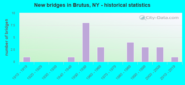
- New bridges - historical statistics
- 11910-1919
- 11940-1949
- 81950-1959
- 31960-1969
- 41980-1989
- 31990-1999
- 32000-2009
- 12010-2019

- Reconstructed bridges - Historical Statistics
- 11980-1989
- 21990-1999
- 22000-2009
- 12010-2019


- Bridge Condition - Deck
- 18.8%Very good
- 31.3%Good
- 18.8%Satisfactory
- 31.3%Fair

- Bridge Condition - Superstructure
- 6.3%Excellent
- 31.3%Very good
- 6.3%Good
- 6.3%Satisfactory
- 31.3%Fair
- 18.8%Poor

- Bridge Condition - Substructure
- 18.8%Very good
- 25.0%Good
- 12.5%Satisfactory
- 31.3%Fair
- 12.5%Poor

- Bridge Condition - Channel
- 41.7%Good
- 16.7%Satisfactory
- 41.7%Fair

- Bridge Condition - Culverts
- 50.0%Good
- 50.0%Poor
Find on map >> Show street view
Structure Number: 102184, Location: 0.9 MI SW JCT RTS 31B+ 34 (Lat: 43.043631, Lng: -76.577658), Route carried "on" structure: State highway 31, Year Built: 1948, Year Reconstructed: 2004, Status: Open, Structure Length: 1.62m (5.31ft), Average Daily Traffic: 3,520 (year 2020), Truck Traffic: 11%, Average Future Daily Traffic: 3,541 (year 2040), Design Load: HS 25 or greater, Features Intersected: COLDSPRINGBROOK
Minimum Vertical Clearance: 30+ m (98+ ft), Kilometerpoint: 12.019, Lanes on structure: 2, Base Highway Network: Yes, Owner: State Highway Agency, Approaching Roadway Width: 11.0m (36.1ft), Skew: 1 degrees, Material/Design: Steel, Design/Construction: Stringer/Multi-beam, Number Of Spans In Main Unit: 1, Length of Maximum Span: 15.8m (51.8ft), Curb-To-Curb Width: 10.4m (34.1ft), Out-to-Out Width: 11.4m (37.4ft)
Condition: Deck: Good, Superstructure: Very good, Substructure: Very good, Channel: Good, Operating Rating: 65.8 metric tons, Method Used To Determine Operating Rating: Load and Resistance Factor Rating (LRFR) rating reported by rating factor(RF) method using HL-93 loadings, Inventory Rating: 50.9 metric tons, Method Used To Determine Inventory Rating: Load and Resistance Factor Rating (LRFR) rating reported by rating factor(RF) method using HL-93 loadings, Structural Evaluation: Equal to present desirable criteria, Deck Geometry: Somewhat better than minimum adequacy, Waterway Adequacy: Superior to present desirable criteria, Approach Roadway Alignment: Equal to present desirable criteria, Length Of Structure Improvement: 1.61m (5.28ft), Designated Inspection Frequency: Every 24 months, Inspection Date: April 2020, Bridge Improvement Cost: $748,000, Roadway Improvement Cost: $438,000, Total Project Cost: $1,185,000 ( Estimate for 2021), Deck Structure Type: Concrete Cast-file-Place, Wearing Surface/Protective System: Wearing Surface: Integral Concrete, Deck Protection: Epoxy Coated Reinforcing
Find on map >> Show street view
Structure Number: 102185, Location: 0.2 MI E JCT RTS 31 + 34 (Lat: 43.055733, Lng: -76.553150), Route carried "on" structure: State highway 31, Year Built: 1950, Year Reconstructed: 2012, Status: Open, Structure Length: 1.49m (4.89ft), Average Daily Traffic: 2,839 (year 2018), Truck Traffic: 16%, Average Future Daily Traffic: 2,856 (year 2040), Design Load: H 20, Features Intersected: PUTNAM BROOK
Minimum Vertical Clearance: 30+ m (98+ ft), Kilometerpoint: 14.674, Lanes on structure: 2, Base Highway Network: Yes, Owner: State Highway Agency, Approaching Roadway Width: 9.1m (29.9ft), Material/Design: Steel, Design/Construction: Stringer/Multi-beam, Number Of Spans In Main Unit: 1, Length of Maximum Span: 14.3m (46.9ft), Curb-To-Curb Width: 10.4m (34.1ft), Out-to-Out Width: 11.4m (37.4ft)
Condition: Deck: Very good, Superstructure: Very good, Substructure: Good, Channel: Good, Inventory Rating: 66.2 metric tons, Method Used To Determine Inventory Rating: Load Factor (LF), Structural Evaluation: Better than present minimum criteria, Deck Geometry: Somewhat better than minimum adequacy, Waterway Adequacy: Meets minimum limits, Approach Roadway Alignment: Equal to present desirable criteria, Length Of Structure Improvement: 1.49m (4.89ft), Designated Inspection Frequency: Every 24 months, Inspection Date: August 2021, Bridge Improvement Cost: $734,000, Roadway Improvement Cost: $430,000, Total Project Cost: $1,164,000 ( Estimate for 2021), Deck Structure Type: Concrete Precast Panels, Wearing Surface/Protective System: Wearing Surface: Integral Concrete
Find on map >> Show street view
Structure Number: 102206, Location: 0.3 MI SE WEEDSPORT (Lat: 43.046289, Lng: -76.548864), Route carried "on" structure: County highway , Year Built: 2001, Status: Open, Structure Length: 2.01m (6.59ft), Average Daily Traffic: 2,686 (year 2017), Truck Traffic: 6%, Average Future Daily Traffic: 3,755 (year 2040), Design Load: HS 25 or greater, Features Intersected: PUTNAM BROOK, Facility Carried by Structure: E. BRUTUS ST.ROAD
Minimum Vertical Clearance: 30+ m (98+ ft), Kilometerpoint: 1.239, Lanes on structure: 2, Owner: County Highway Agency, Approaching Roadway Width: 11.9m (39.0ft), Skew: 3 degrees, Material/Design: Prestressed concrete, Design/Construction: Box Beam or Girders - Multiple, Number Of Spans In Main Unit: 1, Length of Maximum Span: 18.8m (61.7ft), Curb-To-Curb Width: 12.0m (39.4ft), Out-to-Out Width: 13.0m (42.7ft)
Condition: Deck: Very good, Superstructure: Very good, Substructure: Good, Channel: Fair, Operating Rating: 69.4 metric tons, Method Used To Determine Operating Rating: Load Factor (LF), Inventory Rating: 41.6 metric tons, Method Used To Determine Inventory Rating: Load Factor (LF), Structural Evaluation: Better than present minimum criteria, Deck Geometry: Somewhat better than minimum adequacy, Waterway Adequacy: Meets minimum limits, Approach Roadway Alignment: Equal to present desirable criteria, Length Of Structure Improvement: 2.01m (6.59ft), Designated Inspection Frequency: Every 24 months, Inspection Date: June 2021, Bridge Improvement Cost: $1,016,000, Roadway Improvement Cost: $595,000, Total Project Cost: $1,610,000 ( Estimate for 2021), Wearing Surface/Protective System: Wearing Surface: Monolithic Concrete
Find on map >> Show street view
Structure Number: 102335, Location: .3 MI S JCT SH 34 & I90 (Lat: 43.058131, Lng: -76.558828), Route carried "on" structure: State highway 34, Year Built: 1990, Status: Open, Structure Length: 11.34m (37.20ft), Average Daily Traffic: 10,943 (year 2018), Truck Traffic: 11%, Average Future Daily Traffic: 11,315 (year 2040), Design Load: HS 20, Features Intersected: CSX TRANS/AMTRAK, PUTNAM
Minimum Vertical Clearance: 30+ m (98+ ft), Kilometerpoint: 51.424, Lanes on structure: 2, Lanes under structure: 2, Base Highway Network: Yes, Owner: State Highway Agency, Approaching Roadway Width: 12.2m (40.0ft), Skew: 1 degrees, Material/Design: Steel continuous, Design/Construction: Stringer/Multi-beam, Number Of Spans In Main Unit: 3, Length of Maximum Span: 44.8m (147.0ft), Curb-To-Curb Width: 12.2m (40.0ft), Out-to-Out Width: 13.0m (42.7ft)
Condition: Deck: Good, Superstructure: Very good, Substructure: Good, Channel: Satisfactory, Operating Rating: 59.9 metric tons, Method Used To Determine Operating Rating: Load Factor (LF), Inventory Rating: 35.4 metric tons, Method Used To Determine Inventory Rating: Load Factor (LF), Structural Evaluation: Better than present minimum criteria, Deck Geometry: Somewhat better than minimum adequacy, Underclear: High priority of corrective action, Waterway Adequacy: Superior to present desirable criteria, Approach Roadway Alignment: Equal to present desirable criteria, Length Of Structure Improvement: 11.33m (37.17ft), Designated Inspection Frequency: Every 24 months, Inspection Date: July 2021, Bridge Improvement Cost: $3,000,000, Roadway Improvement Cost: $1,757,000, Total Project Cost: $4,757,000 ( Estimate for 2021), Deck Structure Type: Concrete Cast-file-Place, Wearing Surface/Protective System: Wearing Surface: Epoxy Overlay, Deck Protection: Epoxy Coated Reinforcing
Find on map >> Show street view
Structure Number: 102336, Location: JCT OF RTS 34 + I-90 (Lat: 43.062092, Lng: -76.559383), Route carried "on" structure: State highway 34, Year Built: 1953, Status: Open, Structure Length: 6.83m (22.41ft), Average Daily Traffic: 10,943 (year 2018), Truck Traffic: 11%, Average Future Daily Traffic: 11,315 (year 2040), Design Load: HS 20+Mod, Features Intersected: 90IX, RTE I90
Minimum Vertical Clearance: 30+ m (98+ ft), Kilometerpoint: 51.906, Lanes on structure: 2, Lanes under structure: 6, Base Highway Network: Yes, Owner: State Toll Authority, Approaching Roadway Width: 8.5m (27.9ft), Skew: 1 degrees, Material/Design: Steel, Design/Construction: Stringer/Multi-beam, Number Of Spans In Main Unit: 4, Length of Maximum Span: 21.3m (69.9ft), Curb-To-Curb Width: 9.5m (31.2ft), Out-to-Out Width: 10.6m (34.8ft)
Condition: Deck: Fair, Superstructure: Fair, Substructure: Fair, Operating Rating: 59.0 metric tons, Method Used To Determine Operating Rating: Load Factor (LF), Inventory Rating: 35.4 metric tons, Method Used To Determine Inventory Rating: Load Factor (LF), Structural Evaluation: Somewhat better than minimum adequacy, Deck Geometry: Meets minimum limits, Underclear: High priority of corrective action, Approach Roadway Alignment: Equal to present desirable criteria, Length Of Structure Improvement: 6.82m (22.38ft), Designated Inspection Frequency: Every 24 months, Critical Feature Inspection Frequency: Every 12 months, Inspection Date: October 2021, Critical Feature Inspection Date: October 2021, Bridge Improvement Cost: $1,405,000, Roadway Improvement Cost: $823,000, Total Project Cost: $2,228,000 ( Estimate for 2021), Deck Structure Type: Concrete Cast-file-Place, Wearing Surface/Protective System: Wearing Surface: Bituminous
Find on map >> Show street view
Structure Number: 220672, Location: 1.0 MI SW OF WEEDSPORT (Lat: 43.040036, Lng: -76.584194), Route carried "on" structure: Other road , Year Built: 1989, Status: Posted for load, Structure Length: 0.91m (2.99ft), Average Daily Traffic: 262 (year 2020), Truck Traffic: 8%, Average Future Daily Traffic: 367 (year 2040), Features Intersected: NORTH BROOK, Facility Carried by Structure: HAMILTON ROAD
Minimum Vertical Clearance: 30+ m (98+ ft), Kilometerpoint: 1.078, Lanes on structure: 2, Owner: Town or Township Highway Agency, Approaching Roadway Width: 7.0m (23.0ft), Skew: 1 degrees, Material/Design: Steel, Design/Construction: Stringer/Multi-beam, Number Of Spans In Main Unit: 1, Length of Maximum Span: 8.8m (28.9ft), Curb-To-Curb Width: 6.8m (22.3ft), Out-to-Out Width: 7.6m (24.9ft)
Condition: Deck: Fair, Superstructure: Fair, Substructure: Fair, Channel: Satisfactory, Operating Rating: 44.5 metric tons, Method Used To Determine Operating Rating: Load Factor (LF), Inventory Rating: 26.3 metric tons, Method Used To Determine Inventory Rating: Load Factor (LF), Structural Evaluation: Somewhat better than minimum adequacy, Deck Geometry: Meets minimum limits, Waterway Adequacy: Somewhat better than minimum adequacy, Approach Roadway Alignment: Equal to present minimum criteria, Bridge Posting: Required (Relationship of Operating Rating to Maximum Legal Load: > 39.9% below), Length Of Structure Improvement: 0.91m (2.99ft), Designated Inspection Frequency: Every 12 months, Inspection Date: December 2021, Bridge Improvement Cost: $285,000, Roadway Improvement Cost: $167,000, Total Project Cost: $452,000 ( Estimate for 2021), Deck Structure Type: Wood or Timber, Wearing Surface/Protective System: Wearing Surface: Bituminous
Find on map >> Show street view
Structure Number: 220674, Location: 1.0 MI N OF WEEDSPORT (Lat: 43.067608, Lng: -76.559803), Route carried "on" structure: Other road , Year Built: 1983, Status: Open, Structure Length: 1.16m (3.81ft), Average Daily Traffic: 252 (year 2019), Truck Traffic: 8%, Average Future Daily Traffic: 353 (year 2039), Features Intersected: COLD SPRING BROOK, Facility Carried by Structure: RIVER FOREST ROAD
Minimum Vertical Clearance: 30+ m (98+ ft), Kilometerpoint: 0.032, Lanes on structure: 2, Owner: Town or Township Highway Agency, Approaching Roadway Width: 7.0m (23.0ft), Material/Design: Steel, Design/Construction: Stringer/Multi-beam, Number Of Spans In Main Unit: 1, Length of Maximum Span: 10.6m (34.8ft), Curb-To-Curb Width: 8.0m (26.2ft), Out-to-Out Width: 8.6m (28.2ft)
Condition: Deck: Fair, Superstructure: Poor, Substructure: Poor, Channel: Fair, Operating Rating: 94.3 metric tons, Method Used To Determine Operating Rating: Load Factor (LF), Inventory Rating: 70.8 metric tons, Method Used To Determine Inventory Rating: Load Factor (LF), Structural Evaluation: Meets minimum limits, Deck Geometry: Somewhat better than minimum adequacy, Waterway Adequacy: Better than present minimum criteria, Approach Roadway Alignment: Equal to present desirable criteria, Length Of Structure Improvement: 1.15m (3.77ft), Designated Inspection Frequency: Every 24 months, Inspection Date: July 2021, Bridge Improvement Cost: $322,000, Roadway Improvement Cost: $189,000, Total Project Cost: $511,000 ( Estimate for 2021), Deck Structure Type: Wood or Timber, Wearing Surface/Protective System: Wearing Surface: Bituminous
Find on map >> Show street view
Structure Number: 331151, Location: 2MI SE WEEDSPORT (Lat: 43.034806, Lng: -76.526489), Route carried "on" structure: County highway , Year Built: 1961, Status: Posted for load, Structure Length: 0.85m (2.79ft), Average Daily Traffic: 269 (year 2020), Truck Traffic: 8%, Average Future Daily Traffic: 377 (year 2040), Features Intersected: PUTNAM BROOK, Facility Carried by Structure: JERICHO ROAD
Minimum Vertical Clearance: 30+ m (98+ ft), Kilometerpoint: 2.590, Lanes on structure: 2, Owner: County Highway Agency, Approaching Roadway Width: 4.4m (14.4ft), Material/Design: Steel, Design/Construction: Stringer/Multi-beam, Number Of Spans In Main Unit: 1, Length of Maximum Span: 8.2m (26.9ft), Curb-To-Curb Width: 5.5m (18.0ft), Out-to-Out Width: 5.7m (18.7ft)
Condition: Deck: Satisfactory, Superstructure: Poor, Substructure: Poor, Channel: Fair, Operating Rating: 32.7 metric tons, Method Used To Determine Operating Rating: Load Factor (LF), Inventory Rating: 20.0 metric tons, Method Used To Determine Inventory Rating: Load Factor (LF), Structural Evaluation: Meets minimum limits, Deck Geometry: High priority of corrective action, Waterway Adequacy: Better than present minimum criteria, Approach Roadway Alignment: Better than present minimum criteria, Bridge Posting: Required (Relationship of Operating Rating to Maximum Legal Load: > 39.9% below), Length Of Structure Improvement: 0.85m (2.79ft), Designated Inspection Frequency: Every 12 months, Inspection Date: May 2021, Bridge Improvement Cost: $175,000, Roadway Improvement Cost: $102,000, Total Project Cost: $277,000 ( Estimate for 2021), Deck Structure Type: Open Grating, Wearing Surface/Protective System: Wearing Surface: Other
Find on map >> Show street view
Structure Number: 331152, Location: 1 MILE EAST OF WEEDSPORT (Lat: 43.045153, Lng: -76.544939), Route carried "on" structure: County highway , Year Built: 1964, Status: Open, Structure Length: 1.10m (3.61ft), Average Daily Traffic: 384 (year 2017), Truck Traffic: 8%, Average Future Daily Traffic: 538 (year 2037), Design Load: HS 20+Mod, Features Intersected: PUTNAM BROOK, Facility Carried by Structure: SHEPHERD ROAD
Minimum Vertical Clearance: 30+ m (98+ ft), Kilometerpoint: 3.797, Lanes on structure: 2, Owner: County Highway Agency, Approaching Roadway Width: 5.2m (17.1ft), Material/Design: Prestressed concrete, Design/Construction: Box Beam or Girders - Multiple, Number Of Spans In Main Unit: 1, Length of Maximum Span: 10.3m (33.8ft), Curb-To-Curb Width: 6.3m (20.7ft), Out-to-Out Width: 6.5m (21.3ft)
Condition: Deck: Good, Superstructure: Fair, Substructure: Fair, Channel: Fair, Operating Rating: 88.0 metric tons, Method Used To Determine Operating Rating: Load Factor (LF), Inventory Rating: 52.6 metric tons, Method Used To Determine Inventory Rating: Load Factor (LF), Structural Evaluation: Somewhat better than minimum adequacy, Deck Geometry: Meets minimum limits, Waterway Adequacy: Better than present minimum criteria, Approach Roadway Alignment: Meets minimum limits, Length Of Structure Improvement: 1.09m (3.58ft), Designated Inspection Frequency: Every 24 months, Inspection Date: September 2021, Bridge Improvement Cost: $432,000, Roadway Improvement Cost: $253,000, Total Project Cost: $686,000 ( Estimate for 2021), Wearing Surface/Protective System: Wearing Surface: Bituminous
Find on map >> Show street view
Structure Number: 336827, Location: 1.3 MI NORTH OF NYS RTE 5 (Lat: 43.023394, Lng: -76.518994), Route carried "on" structure: County highway , Year Built: 2014, Status: Open, Structure Length: 1.10m (3.61ft), Average Daily Traffic: 316 (year 2019), Truck Traffic: 8%, Average Future Daily Traffic: 442 (year 2039), Features Intersected: PUTNAM BROOK, Facility Carried by Structure: JERICHO ROAD
Minimum Vertical Clearance: 30+ m (98+ ft), Kilometerpoint: 1.142, Lanes on structure: 2, Owner: County Highway Agency, Approaching Roadway Width: 6.7m (22.0ft), Skew: 3 degrees, Material/Design: Steel, Design/Construction: Culvert, Number Of Spans In Main Unit: 2, Length of Maximum Span: 4.5m (14.8ft)
Condition: Channel: Fair, Culverts: Poor, Operating Rating: 74.5 metric tons, Method Used To Determine Operating Rating: Field evaluation and documented engineering judgment, Inventory Rating: 24.5 metric tons, Method Used To Determine Inventory Rating: Field evaluation and documented engineering judgment, Structural Evaluation: Meets minimum limits, Waterway Adequacy: Better than present minimum criteria, Approach Roadway Alignment: Equal to present desirable criteria, Length Of Structure Improvement: 1.09m (3.58ft), Designated Inspection Frequency: Every 24 months, Inspection Date: May 2021, Bridge Improvement Cost: $171,000, Roadway Improvement Cost: $100,000, Total Project Cost: $270,000 ( Estimate for 2021)
Find on map >> Show street view
Structure Number: 371427, Location: .5 MILE NW OF WEEDSPORT (Lat: 43.051642, Lng: -76.579258), Route carried "on" structure: County highway , Year Built: 1993, Status: Open, Structure Length: 2.13m (6.99ft), Average Daily Traffic: 352 (year 2017), Truck Traffic: 5%, Average Future Daily Traffic: 493 (year 2037), Design Load: HS 25 or greater, Features Intersected: CSX TRANS/AMTRAK, Facility Carried by Structure: OAKLAND ROAD
Minimum Vertical Clearance: 30+ m (98+ ft), Kilometerpoint: 3.765, Lanes on structure: 2, Owner: County Highway Agency, Approaching Roadway Width: 7.3m (24.0ft), Material/Design: Steel, Design/Construction: Truss - Thru, Number Of Spans In Main Unit: 1, Length of Maximum Span: 20.7m (67.9ft), Curb-To-Curb Width: 7.3m (24.0ft), Out-to-Out Width: 8.1m (26.6ft)
Condition: Deck: Fair, Superstructure: Poor, Substructure: Good, Operating Rating: 48.1 metric tons, Method Used To Determine Operating Rating: Load Factor (LF), Inventory Rating: 28.1 metric tons, Method Used To Determine Inventory Rating: Load Factor (LF), Structural Evaluation: Meets minimum limits, Deck Geometry: Somewhat better than minimum adequacy, Underclear: Somewhat better than minimum adequacy, Approach Roadway Alignment: High priority of corrective action, Length Of Structure Improvement: 2.13m (6.99ft), Designated Inspection Frequency: Every 24 months, Critical Feature Inspection Frequency: Every 24 months, Inspection Date: December 2020, Critical Feature Inspection Date: December 2020, Bridge Improvement Cost: $2,489,000, Roadway Improvement Cost: $1,458,000, Total Project Cost: $3,947,000 ( Estimate for 2021), Deck Structure Type: Corrugated Steel, Wearing Surface/Protective System: Wearing Surface: Bituminous
Find on map >> Show street view
Structure Number: 402337, Location: JCT.RTE.34 + CANAL (Lat: 43.071114, Lng: -76.556472), Route carried "on" structure: State highway 34, Year Built: 1964, Status: Open, Structure Length: 19.08m (62.60ft), Average Daily Traffic: 2,476 (year 2018), Truck Traffic: 11%, Average Future Daily Traffic: 2,491 (year 2040), Design Load: HS 20, Features Intersected: ERIE BARGE CANAL, SENECA
Minimum Vertical Clearance: 30+ m (98+ ft), Kilometerpoint: 52.840, Lanes on structure: 2, Base Highway Network: Yes, Owner: State Highway Agency, Approaching Roadway Width: 9.8m (32.2ft), Navigation Control: Yes ( Vertical Clearance: 4.8m (15.7ft), Horizontal Clearance: 45.7m (149.9ft)), Material/Design: Steel, Design/Construction: Stringer/Multi-beam, Number Of Spans In Main Unit: 5, Length of Maximum Span: 64.0m (210.0ft), Curb or Sidewalk Widths: Left: 0.5m (1.6ft), Right: 0.5m (1.6ft), Curb-To-Curb Width: 9.3m (30.5ft), Out-to-Out Width: 10.8m (35.4ft)
Condition: Deck: Fair, Superstructure: Fair, Substructure: Fair, Channel: Good, Operating Rating: 44.5 metric tons, Method Used To Determine Operating Rating: Load Factor (LF), Inventory Rating: 26.3 metric tons, Method Used To Determine Inventory Rating: Load Factor (LF), Structural Evaluation: Somewhat better than minimum adequacy, Deck Geometry: Meets minimum limits, Waterway Adequacy: Equal to present minimum criteria, Approach Roadway Alignment: Meets minimum limits, Length Of Structure Improvement: 19.08m (62.60ft), Designated Inspection Frequency: Every 24 months, Underwater Inspection Frequency: Every 60 months, Inspection Date: August 2021, Underwater Inspection Date: July 2017, Bridge Improvement Cost: $3,925,000, Roadway Improvement Cost: $2,298,000, Total Project Cost: $6,223,000 ( Estimate for 2021), Deck Structure Type: Concrete Cast-file-Place, Wearing Surface/Protective System: Wearing Surface: Bituminous
Find on map >> Show street view
Structure Number: 443102, Location: 2.3 MI E JCT SH34 & CANAL (Lat: 43.076481, Lng: -76.514022), Route carried "on" structure: County highway , Year Built: 1912, Year Reconstructed: 1990, Status: Posted for load, Structure Length: 14.36m (47.11ft), Average Daily Traffic: 367 (year 2020), Truck Traffic: 8%, Average Future Daily Traffic: 514 (year 2040), Features Intersected: ERIE CANAL/SEN RV, Facility Carried by Structure: BONTA BRIDGE ROAD
Minimum Vertical Clearance: 3.99m (13.09ft), Kilometerpoint: 5.278, Lanes on structure: 1, Owner: State Highway Agency, Approaching Roadway Width: 6.1m (20.0ft), Navigation Control: Yes ( Vertical Clearance: 4.8m (15.7ft), Horizontal Clearance: 59.4m (194.9ft)), Material/Design: Steel, Design/Construction: Truss - Thru, Number Of Spans In Main Unit: 3, Length of Maximum Span: 60.0m (196.9ft), Curb-To-Curb Width: 4.3m (14.1ft), Out-to-Out Width: 5.0m (16.4ft)
Condition: Deck: Satisfactory, Superstructure: Fair, Substructure: Fair, Channel: Good, Operating Rating: 26.3 metric tons, Method Used To Determine Operating Rating: Load Factor (LF), Inventory Rating: 15.4 metric tons, Method Used To Determine Inventory Rating: Load Factor (LF), Structural Evaluation: Meets minimum limits, Deck Geometry: High priority of replacement, Waterway Adequacy: Equal to present desirable criteria, Approach Roadway Alignment: Meets minimum limits, Bridge Posting: Required (Relationship of Operating Rating to Maximum Legal Load: > 39.9% below), Length Of Structure Improvement: 14.35m (47.08ft), Designated Inspection Frequency: Every 12 months, Critical Feature Inspection Frequency: Every 12 months, Underwater Inspection Frequency: Every 60 months, Inspection Date: September 2021, Critical Feature Inspection Date: September 2021, Underwater Inspection Date: June 2019, Bridge Improvement Cost: $5,112,000, Roadway Improvement Cost: $2,994,000, Total Project Cost: $8,106,000 ( Estimate for 2021), Deck Structure Type: Open Grating, Wearing Surface/Protective System: Wearing Surface: Other
Find on map >> Show street view
Structure Number: 551029, Location: 2.7MI E INTCGE 40 ON I90 (Lat: 43.072314, Lng: -76.513181), Route carried "on" structure: Interstate 90, Year Built: 1953, Year Reconstructed: 2009, Status: Open, Structure Length: 0.94m (3.08ft), Average Daily Traffic: 28,463 (year 2020), Truck Traffic: 29%, Average Future Daily Traffic: 31,907 (year 2040), Design Load: HS 20+Mod, Features Intersected: BONTA BR RD CR14
Minimum Vertical Clearance: 30+ m (98+ ft), Kilometerpoint: 18.986, Lanes on structure: 4, Lanes under structure: 2, Base Highway Network: Yes, Toll: On Interstate toll segment, Owner: State Toll Authority, Approaching Roadway Width: 29.9m (98.1ft), Skew: 21 degrees, Material/Design: Concrete, Design/Construction: Culvert, Number Of Spans In Main Unit: 1, Length of Maximum Span: 9.1m (29.9ft)
Condition: Culverts: Good, Operating Rating: 79.1 metric tons, Method Used To Determine Operating Rating: Field evaluation and documented engineering judgment, Inventory Rating: 32.7 metric tons, Method Used To Determine Inventory Rating: Field evaluation and documented engineering judgment, Structural Evaluation: Better than present minimum criteria, Underclear: High priority of corrective action, Approach Roadway Alignment: Equal to present desirable criteria, Length Of Structure Improvement: 0.94m (3.08ft), Designated Inspection Frequency: Every 24 months, Inspection Date: May 2020, Bridge Improvement Cost: $1,693,000, Roadway Improvement Cost: $991,000, Total Project Cost: $2,684,000 ( Estimate for 2021), Wearing Surface/Protective System: Wearing Surface: Monolithic Concrete, Membrane: Other
Find on map >> Show street view
Structure Number: 551031, Location: I90 EXIT 40 RAMP BRIDGE (Lat: 43.061269, Lng: -76.564572), Route carried "on" structure: Ramp Interstate , Year Built: 2003, Status: Open, Structure Length: 7.07m (23.20ft), Average Daily Traffic: 997 (year 2018), Truck Traffic: 11%, Average Future Daily Traffic: 1,117 (year 2040), Design Load: HS 25 or greater, Features Intersected: 90IX EB, RTE I90, Facility Carried by Structure: EXIT 40 RAMP
Minimum Vertical Clearance: 30+ m (98+ ft), Kilometerpoint: 0.531, Lanes on structure: 2, Lanes under structure: 5, Toll: On Interstate toll segment, Owner: State Toll Authority, Approaching Roadway Width: 15.2m (49.9ft), Skew: 20 degrees, Material/Design: Steel continuous, Design/Construction: Stringer/Multi-beam, Number Of Spans In Main Unit: 2, Length of Maximum Span: 35.1m (115.2ft), Curb-To-Curb Width: 14.9m (48.9ft), Out-to-Out Width: 16.1m (52.8ft)
Condition: Deck: Very good, Superstructure: Very good, Substructure: Very good, Inventory Rating: 65.3 metric tons, Method Used To Determine Inventory Rating: Load Factor (LF), Structural Evaluation: Equal to present desirable criteria, Deck Geometry: Superior to present desirable criteria, Underclear: Meets minimum limits, Approach Roadway Alignment: Equal to present desirable criteria, Length Of Structure Improvement: 7.07m (23.20ft), Designated Inspection Frequency: Every 24 months, Inspection Date: September 2021, Bridge Improvement Cost: $2,178,000, Roadway Improvement Cost: $1,276,000, Total Project Cost: $3,454,000 ( Estimate for 2021), Deck Structure Type: Concrete Cast-file-Place, Wearing Surface/Protective System: Wearing Surface: Integral Concrete, Deck Protection: Galvanized Reinforcing
Find on map >> Show street view
Structure Number: 5510329, Location: 0.5 MI N OF EX 40 ON I90 (Lat: 43.059925, Lng: -76.570119), Route carried "on" structure: Interstate 90, Year Built: 1950, Year Reconstructed: 2010, Status: Open, Structure Length: 1.71m (5.61ft), Average Daily Traffic: 27,070 (year 2020), Truck Traffic: 30%, Average Future Daily Traffic: 30,345 (year 2040), Design Load: HS 25 or greater, Features Intersected: COLD SPRING BROOK
Minimum Vertical Clearance: 30+ m (98+ ft), Kilometerpoint: 14.143, Lanes on structure: 4, Base Highway Network: Yes, Toll: On Interstate toll segment, Owner: State Toll Authority, Approaching Roadway Width: 37.8m (124.0ft), Skew: 20 degrees, Material/Design: Steel, Design/Construction: Stringer/Multi-beam, Number Of Spans In Main Unit: 1, Length of Maximum Span: 15.8m (51.8ft), Curb-To-Curb Width: 38.4m (126.0ft), Out-to-Out Width: 39.6m (129.9ft)
Condition: Deck: Good, Superstructure: Excellent, Substructure: Very good, Channel: Good, Operating Rating: 67.7 metric tons, Method Used To Determine Operating Rating: Load and Resistance Factor Rating (LRFR) rating reported by rating factor(RF) method using HL-93 loadings, Inventory Rating: 52.2 metric tons, Method Used To Determine Inventory Rating: Load and Resistance Factor Rating (LRFR) rating reported by rating factor(RF) method using HL-93 loadings, Structural Evaluation: Equal to present desirable criteria, Deck Geometry: Superior to present desirable criteria, Waterway Adequacy: High priority of corrective action, Approach Roadway Alignment: Equal to present desirable criteria, Length Of Structure Improvement: 1.70m (5.58ft), Designated Inspection Frequency: Every 24 months, Inspection Date: November 2020, Bridge Improvement Cost: $2,534,000, Roadway Improvement Cost: $1,484,000, Total Project Cost: $4,018,000 ( Estimate for 2021), Deck Structure Type: Concrete Cast-file-Place, Wearing Surface/Protective System: Wearing Surface: Integral Concrete, Deck Protection: Galvanized Reinforcing
Find on map >> Show street view
Structure Number: 551033, Location: 1.1 MI W EXIT 40 ON 90I (Lat: 43.056897, Lng: -76.585142), Route carried "on" structure: County highway , Year Built: 1988, Status: Open, Structure Length: 6.71m (22.01ft), Average Daily Traffic: 352 (year 2017), Truck Traffic: 5%, Average Future Daily Traffic: 493 (year 2037), Design Load: HS 20+Mod, Features Intersected: 90IX EB, RTE I90, Facility Carried by Structure: OAKLAND RD CR 13B
Minimum Vertical Clearance: 30+ m (98+ ft), Kilometerpoint: 2.655, Lanes on structure: 2, Lanes under structure: 4, Owner: State Toll Authority, Approaching Roadway Width: 9.1m (29.9ft), Skew: 2 degrees, Material/Design: Steel continuous, Design/Construction: Stringer/Multi-beam, Number Of Spans In Main Unit: 2, Length of Maximum Span: 34.4m (112.9ft), Curb-To-Curb Width: 9.8m (32.2ft), Out-to-Out Width: 10.4m (34.1ft)
Condition: Deck: Satisfactory, Superstructure: Good, Substructure: Satisfactory, Operating Rating: 71.7 metric tons, Method Used To Determine Operating Rating: Load Factor (LF), Inventory Rating: 42.6 metric tons, Method Used To Determine Inventory Rating: Load Factor (LF), Structural Evaluation: Equal to present minimum criteria, Deck Geometry: Better than present minimum criteria, Underclear: High priority of corrective action, Approach Roadway Alignment: Equal to present minimum criteria, Length Of Structure Improvement: 6.70m (21.98ft), Designated Inspection Frequency: Every 24 months, Inspection Date: April 2021, Bridge Improvement Cost: $1,584,000, Roadway Improvement Cost: $928,000, Total Project Cost: $2,512,000 ( Estimate for 2021), Deck Structure Type: Concrete Cast-file-Place, Wearing Surface/Protective System: Wearing Surface: Integral Concrete, Deck Protection: Epoxy Coated Reinforcing
Find on map >> Show street view
Structure Number: 551034, Location: 1.7 MI NW OF WEEDSPORT (Lat: 43.055092, Lng: -76.595194), Route carried "on" structure: Other road , Year Built: 1953, Year Reconstructed: 1991, Status: Open, Structure Length: 6.58m (21.59ft), Average Daily Traffic: 51 (year 2020), Truck Traffic: 8%, Average Future Daily Traffic: 71 (year 2040), Design Load: HS 20+Mod, Features Intersected: 90IX EB, RTE I90, Facility Carried by Structure: TOWN LINE RD
Minimum Vertical Clearance: 30+ m (98+ ft), Kilometerpoint: 0.322, Lanes on structure: 2, Lanes under structure: 4, Owner: State Toll Authority, Approaching Roadway Width: 5.5m (18.0ft), Skew: 1 degrees, Material/Design: Steel, Design/Construction: Stringer/Multi-beam, Number Of Spans In Main Unit: 4, Length of Maximum Span: 19.8m (65.0ft), Curb-To-Curb Width: 9.4m (30.8ft), Out-to-Out Width: 10.1m (33.1ft)
Condition: Deck: Good, Superstructure: Satisfactory, Substructure: Satisfactory, Operating Rating: 86.2 metric tons, Method Used To Determine Operating Rating: Load Factor (LF), Inventory Rating: 51.7 metric tons, Method Used To Determine Inventory Rating: Load Factor (LF), Structural Evaluation: Equal to present minimum criteria, Deck Geometry: Better than present minimum criteria, Underclear: High priority of corrective action, Approach Roadway Alignment: Equal to present desirable criteria, Length Of Structure Improvement: 6.58m (21.59ft), Designated Inspection Frequency: Every 24 months, Inspection Date: September 2021, Bridge Improvement Cost: $1,381,000, Roadway Improvement Cost: $809,000, Total Project Cost: $2,190,000 ( Estimate for 2021), Deck Structure Type: Concrete Cast-file-Place, Wearing Surface/Protective System: Wearing Surface: Integral Concrete, Deck Protection: Epoxy Coated Reinforcing
Find on map >> Show street view
Structure Number: 102335, Location: .3 MI S JCT SH 34 & I90 (Lat: 43.058131, Lng: -76.558828), Route carried "under" structure: ServiceOther road , Year Built: 1990, Structure Length: 0. m, Average Daily Traffic: 60 (year 1991), Features Intersected: CSX TRANS/AMTRAK, PUTNAM, Facility Carried by Structure: RTE 34
Minimum Vertical Clearance: 6.86m (22.51ft), Kilometerpoint: 0.000, Lanes on structure: 2, Lanes under structure: 2, Material/Design: Steel continuous, Design/Construction: Stringer/Multi-beam, Length of Maximum Span: 44.8m (147.0ft)
Find on map >> Show street view
Structure Number: 102336, Location: JCT OF RTS 34 + I-90 (Lat: 43.062092, Lng: -76.559383), Route carried "under" structure: Interstate 90, Year Built: 1953, Structure Length: 0. m, Average Daily Traffic: 7,450 (year 1975), Features Intersected: 90IX, RTE I90, Facility Carried by Structure: RTE 34
Minimum Vertical Clearance: 4.47m (14.67ft), Kilometerpoint: 489.007, Lanes on structure: 2, Lanes under structure: 3, Toll: On Interstate toll segment, Material/Design: Steel, Design/Construction: Stringer/Multi-beam, Length of Maximum Span: 21.3m (69.9ft)
Find on map >> Show street view
Structure Number: 551029, Location: 2.7MI E INTCGE 40 ON I90 (Lat: 43.072314, Lng: -76.513181), Route carried "under" structure: County highway , Year Built: 1953, Structure Length: 0. m, Average Daily Traffic: 367 (year 2020), Truck Traffic: 8%, Features Intersected: BONTA BR RD CR14, Facility Carried by Structure: RTE I90
Minimum Vertical Clearance: 4.17m (13.68ft), Kilometerpoint: 4.827, Lanes on structure: 4, Lanes under structure: 2, Material/Design: Concrete, Design/Construction: Culvert, Length of Maximum Span: 9.1m (29.9ft)
Find on map >> Show street view
Structure Number: 551031, Location: I90 EXIT 40 RAMP BRIDGE (Lat: 43.061269, Lng: -76.564572), Route carried "under" structure: Interstate 90, Year Built: 2003, Structure Length: 0. m, Average Daily Traffic: 13,500 (year 2000), Features Intersected: 90IX EB, RTE I90, Facility Carried by Structure: EXIT 40 RAMP
Minimum Vertical Clearance: 4.78m (15.68ft), Kilometerpoint: 489.442, Lanes on structure: 2, Lanes under structure: 3, Toll: On Interstate toll segment, Material/Design: Steel continuous, Design/Construction: Stringer/Multi-beam, Length of Maximum Span: 35.1m (115.2ft)
Find on map >> Show street view
Structure Number: 551033, Location: 1.1 MI W EXIT 40 ON 90I (Lat: 43.056897, Lng: -76.585142), Route carried "under" structure: Interstate 90, Year Built: 1988, Structure Length: 0. m, Average Daily Traffic: 6,950 (year 1975), Features Intersected: 90IX EB, RTE I90, Facility Carried by Structure: OAKLAND RD CR 13B
Minimum Vertical Clearance: 5.33m (17.49ft), Kilometerpoint: 491.179, Lanes on structure: 2, Lanes under structure: 2, Toll: On Interstate toll segment, Material/Design: Steel continuous, Design/Construction: Stringer/Multi-beam, Length of Maximum Span: 34.4m (112.9ft)
Find on map >> Show street view
Structure Number: 551034, Location: 1.7 MI NW OF WEEDSPORT (Lat: 43.055092, Lng: -76.595194), Route carried "under" structure: Interstate 90, Year Built: 1953, Structure Length: 0. m, Average Daily Traffic: 6,950 (year 1975), Features Intersected: 90IX EB, RTE I90, Facility Carried by Structure: TOWN LINE RD
Minimum Vertical Clearance: 4.42m (14.50ft), Kilometerpoint: 492.032, Lanes on structure: 2, Lanes under structure: 2, Toll: On Interstate toll segment, Material/Design: Steel, Design/Construction: Stringer/Multi-beam, Length of Maximum Span: 19.8m (65.0ft)