Bridge Statistics for Buckatunna, Mississippi (MS)
Condition, Traffic, Stress, Structural Evaluation, Project Costs
- National Bridge Inventory (NBI) Statistics
- 23Number of bridges
- 489ft / 149mTotal length
- $8,326,000Total costs
- 15,555Total average daily traffic
- 2,375Total average daily truck traffic
- 19,732Total future (year 2034) average daily traffic
- National Bridge Inventory (NBI) Registered Bridges for Buckatunna
- No street view available for this location
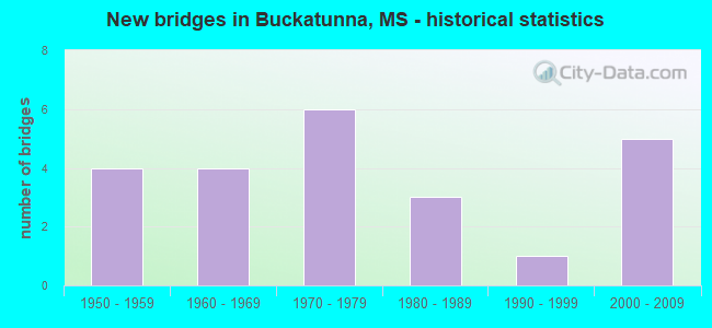
- New bridges - historical statistics
- 41950-1959
- 41960-1969
- 61970-1979
- 31980-1989
- 11990-1999
- 52000-2009


- Bridge Condition - Deck
- 5.9%Excellent
- 5.9%Very good
- 29.4%Good
- 41.2%Satisfactory
- 11.8%Fair
- 5.9%Poor

- Bridge Condition - Superstructure
- 5.6%Excellent
- 22.2%Very good
- 33.3%Good
- 11.1%Satisfactory
- 16.7%Fair
- 11.1%Poor

- Bridge Condition - Substructure
- 22.2%Very good
- 16.7%Good
- 22.2%Satisfactory
- 33.3%Fair
- 5.6%Poor

- Bridge Condition - Channel
- 8.7%Very good
- 13.0%Good
- 34.8%Satisfactory
- 34.8%Fair
- 8.7%Poor

- Bridge Condition - Culverts
- 20.0%Good
- 80.0%Satisfactory
Find on map >> Show street view
Structure Number: 21000450770070A, Location: 7.0 MI N ALA STATE LINE (Lat: 31.518664, Lng: -88.511014), Route carried "on" structure: US 45, Year Built: 2006, Status: Open, Structure Length: 3.90m (12.80ft), Average Daily Traffic: 2,000 (year 2020), Truck Traffic: 17%, Average Future Daily Traffic: 2,100 (year 2040), Design Load: HS 20, Features Intersected: BUCKATUNNA RIVER RELIEF
Minimum Vertical Clearance: 30+ m (98+ ft), Kilometerpoint: 41.841, Lanes on structure: 2, Base Highway Network: Yes (Inventory Route: 4, Subroute: 1), Owner: State Highway Agency, Approaching Roadway Width: 12.0m (39.4ft), Skew: 10 degrees, Material/Design: Prestressed concrete continuous, Design/Construction: Stringer/Multi-beam, Number Of Spans In Main Unit: 3, Length of Maximum Span: 13.0m (42.7ft), Curb-To-Curb Width: 12.0m (39.4ft), Out-to-Out Width: 12.9m (42.3ft)
Condition: Deck: Good, Superstructure: Very good, Substructure: Very good, Channel: Very good, Operating Rating: 59.3 metric tons, Method Used To Determine Operating Rating: Load Factor (LF), Inventory Rating: 35.5 metric tons, Method Used To Determine Inventory Rating: Load Factor (LF), Structural Evaluation: Equal to present desirable criteria, Deck Geometry: Better than present minimum criteria, Waterway Adequacy: Equal to present desirable criteria, Approach Roadway Alignment: Equal to present desirable criteria, Designated Inspection Frequency: Every 24 months, Inspection Date: September 2021, Deck Structure Type: Concrete Cast-file-Place
Find on map >> Show street view
Structure Number: 21000450770070B, Location: 7.0 MI N ALA STATE LINE (Lat: 31.518561, Lng: -88.510436), Route carried "on" structure: US 45, Year Built: 2003, Status: Open, Structure Length: 3.90m (12.80ft), Average Daily Traffic: 2,000 (year 2020), Truck Traffic: 22%, Average Future Daily Traffic: 2,100 (year 2040), Design Load: HS 20, Features Intersected: BUCKATUNNA CREEK RELIEF
Minimum Vertical Clearance: 30+ m (98+ ft), Kilometerpoint: 10.781, Lanes on structure: 2, Base Highway Network: Yes (Inventory Route: 4, Subroute: 1), Owner: State Highway Agency, Approaching Roadway Width: 12.0m (39.4ft), Skew: 10 degrees, Material/Design: Prestressed concrete continuous, Design/Construction: Stringer/Multi-beam, Number Of Spans In Main Unit: 3, Length of Maximum Span: 13.0m (42.7ft), Curb-To-Curb Width: 12.0m (39.4ft), Out-to-Out Width: 12.9m (42.3ft)
Condition: Deck: Very good, Superstructure: Very good, Substructure: Very good, Channel: Very good, Operating Rating: 59.3 metric tons, Method Used To Determine Operating Rating: Load Factor (LF), Inventory Rating: 35.5 metric tons, Method Used To Determine Inventory Rating: Load Factor (LF), Structural Evaluation: Equal to present desirable criteria, Deck Geometry: Better than present minimum criteria, Waterway Adequacy: Equal to present desirable criteria, Approach Roadway Alignment: Equal to present desirable criteria, Designated Inspection Frequency: Every 24 months, Inspection Date: September 2021, Deck Structure Type: Concrete Cast-file-Place
Find on map >> Show street view
Structure Number: 21000450770071A, Location: 7.1 MI N ALA STATE LINE (Lat: 31.522092, Lng: -88.513853), Route carried "on" structure: US 45, Year Built: 2006, Status: Open, Structure Length: 34.68m (113.78ft), Average Daily Traffic: 2,000 (year 2020), Truck Traffic: 17%, Average Future Daily Traffic: 2,100 (year 2040), Design Load: HS 20, Features Intersected: BUCKATUNNA RIVER
Minimum Vertical Clearance: 30+ m (98+ ft), Kilometerpoint: 41.376, Lanes on structure: 2, Base Highway Network: Yes (Inventory Route: 4, Subroute: 1), Owner: State Highway Agency, Approaching Roadway Width: 12.0m (39.4ft), Skew: 12 degrees, Material/Design: Prestressed concrete, Design/Construction: Stringer/Multi-beam, Number Of Spans In Main Unit: 1, Number Of Approach Spans: 23, Length of Maximum Span: 33.0m (108.3ft), Curb-To-Curb Width: 12.0m (39.4ft), Out-to-Out Width: 12.9m (42.3ft)
Condition: Deck: Good, Superstructure: Very good, Substructure: Very good, Channel: Good, Operating Rating: 57.2 metric tons, Method Used To Determine Operating Rating: Load Factor (LF), Inventory Rating: 24.5 metric tons, Method Used To Determine Inventory Rating: Load Factor (LF), Structural Evaluation: Equal to present minimum criteria, Deck Geometry: Better than present minimum criteria, Waterway Adequacy: Equal to present desirable criteria, Approach Roadway Alignment: Equal to present desirable criteria, Designated Inspection Frequency: Every 24 months, Inspection Date: September 2021, Deck Structure Type: Concrete Cast-file-Place
Find on map >> Show street view
Structure Number: 21000450770071B, Location: 7.1 MI N ALA STATE LINE (Lat: 31.519858, Lng: -88.511506), Route carried "on" structure: US 45, Year Built: 2003, Status: Open, Structure Length: 34.68m (113.78ft), Average Daily Traffic: 2,000 (year 2020), Truck Traffic: 22%, Average Future Daily Traffic: 2,100 (year 2040), Design Load: HS 20, Features Intersected: BUCKATUNNA CREEK
Minimum Vertical Clearance: 30+ m (98+ ft), Kilometerpoint: 10.956, Lanes on structure: 2, Base Highway Network: Yes (Inventory Route: 4, Subroute: 1), Owner: State Highway Agency, Approaching Roadway Width: 12.0m (39.4ft), Skew: 12 degrees, Material/Design: Prestressed concrete, Design/Construction: Stringer/Multi-beam, Number Of Spans In Main Unit: 1, Number Of Approach Spans: 23, Length of Maximum Span: 33.0m (108.3ft), Curb-To-Curb Width: 12.0m (39.4ft), Out-to-Out Width: 12.9m (42.3ft)
Condition: Deck: Good, Superstructure: Very good, Substructure: Very good, Channel: Good, Operating Rating: 57.2 metric tons, Method Used To Determine Operating Rating: Load Factor (LF), Inventory Rating: 24.5 metric tons, Method Used To Determine Inventory Rating: Load Factor (LF), Structural Evaluation: Equal to present minimum criteria, Deck Geometry: Better than present minimum criteria, Waterway Adequacy: Equal to present desirable criteria, Approach Roadway Alignment: Equal to present desirable criteria, Designated Inspection Frequency: Every 24 months, Inspection Date: September 2021, Deck Structure Type: Concrete Cast-file-Place
Find on map >> Show street view
Structure Number: SA7700000000007, Location: SEC 11 T 6N R 6W B (Lat: 31.500722, Lng: -88.553139), Route carried "on" structure: County highway 102, Year Built: 1983, Status: Open, Structure Length: 0.67m (2.20ft), Average Daily Traffic: 100 (year 2020), Truck Traffic: 8%, Average Future Daily Traffic: 150 (year 2040), Design Load: HS 20, Features Intersected: BREWERS CREEK, Facility Carried by Structure: CHCORA-GREEN CO RD
Minimum Vertical Clearance: 30+ m (98+ ft), Kilometerpoint: 6.437, Lanes on structure: 2, Owner: County Highway Agency, Approaching Roadway Width: 7.9m (25.9ft), Material/Design: Concrete, Design/Construction: Culvert, Number Of Spans In Main Unit: 2, Length of Maximum Span: 3.0m (9.8ft)
Condition: Channel: Fair, Culverts: Satisfactory, Operating Rating: 61.2 metric tons, Method Used To Determine Operating Rating: Load Factor (LF) rating reported by rating factor (RF) method using MS18 loading, Inventory Rating: 36.6 metric tons, Method Used To Determine Inventory Rating: Load Factor (LF) rating reported by rating factor (RF) method using MS18 loading, Structural Evaluation: Equal to present minimum criteria, Waterway Adequacy: Equal to present minimum criteria, Approach Roadway Alignment: Equal to present desirable criteria, Designated Inspection Frequency: Every 24 months, Inspection Date: March 2021
Find on map >> Show street view
Structure Number: SA7700000000008, Location: SEC 15 T 6N R 6W B (Lat: 31.480903, Lng: -88.570586), Route carried "on" structure: County highway 102, Year Built: 1974, Status: Posted for load, Structure Length: 1.74m (5.71ft), Average Daily Traffic: 50 (year 2018), Truck Traffic: 4%, Average Future Daily Traffic: 75 (year 2038), Design Load: H 15, Features Intersected: HENRY CREEK, Facility Carried by Structure: CHCORA-GREEN CO RD
Minimum Vertical Clearance: 30+ m (98+ ft), Kilometerpoint: 9.656, Lanes on structure: 2, Owner: County Highway Agency, Approaching Roadway Width: 6.7m (22.0ft), Material/Design: Concrete, Design/Construction: Channel Beam, Number Of Spans In Main Unit: 3, Length of Maximum Span: 5.8m (19.0ft), Curb or Sidewalk Widths: Left: 0.2m (0.7ft), Right: 0.2m (0.7ft), Curb-To-Curb Width: 7.1m (23.3ft), Out-to-Out Width: 7.5m (24.6ft)
Condition: Deck: Good, Superstructure: Good, Substructure: Fair, Channel: Satisfactory, Operating Rating: 41.2 metric tons, Method Used To Determine Operating Rating: Load Factor (LF), Inventory Rating: 24.7 metric tons, Method Used To Determine Inventory Rating: Load Factor (LF), Structural Evaluation: Somewhat better than minimum adequacy, Deck Geometry: Somewhat better than minimum adequacy, Waterway Adequacy: Better than present minimum criteria, Approach Roadway Alignment: Equal to present desirable criteria, Length Of Structure Improvement: 2.10m (6.89ft), Designated Inspection Frequency: Every 24 months, Inspection Date: September 2020, Bridge Improvement Cost: $126,000, Roadway Improvement Cost: $13,000, Total Project Cost: $156,000 ( Estimate for 2019), Deck Structure Type: Concrete Precast Panels, Wearing Surface/Protective System: Wearing Surface: Monolithic Concrete
Find on map >> Show street view
Structure Number: SA7700000000033, Location: SEC 11 T 7N R 5W B (Lat: 31.586006, Lng: -88.465286), Route carried "on" structure: County highway 59, Year Built: 1962, Status: Open, Structure Length: 3.54m (11.61ft), Average Daily Traffic: 750 (year 2018), Truck Traffic: 8%, Average Future Daily Traffic: 1,125 (year 2038), Design Load: H 15, Features Intersected: LITTLE RED CREEK, Facility Carried by Structure: BUCATNA-MILLRY RD
Minimum Vertical Clearance: 30+ m (98+ ft), Kilometerpoint: 37.980, Lanes on structure: 2, Owner: County Highway Agency, Approaching Roadway Width: 6.7m (22.0ft), Material/Design: Steel, Design/Construction: Stringer/Multi-beam, Number Of Spans In Main Unit: 1, Number Of Approach Spans: 4, Length of Maximum Span: 12.2m (40.0ft), Curb or Sidewalk Widths: Left: 0.3m (1.0ft), Right: 0.3m (1.0ft), Curb-To-Curb Width: 6.7m (22.0ft), Out-to-Out Width: 7.4m (24.3ft)
Condition: Deck: Satisfactory, Superstructure: Fair, Substructure: Fair, Channel: Fair, Operating Rating: 25.4 metric tons, Method Used To Determine Operating Rating: Load Factor (LF), Inventory Rating: 15.2 metric tons, Method Used To Determine Inventory Rating: Load Factor (LF), Structural Evaluation: Meets minimum limits, Deck Geometry: Meets minimum limits, Waterway Adequacy: Equal to present desirable criteria, Approach Roadway Alignment: Equal to present desirable criteria, Bridge Posting: Required (Relationship of Operating Rating to Maximum Legal Load: 30.0 - 39.9% below), Length Of Structure Improvement: 4.88m (16.01ft), Designated Inspection Frequency: Every 24 months, Inspection Date: September 2021, Bridge Improvement Cost: $291,000, Roadway Improvement Cost: $29,000, Total Project Cost: $358,000 ( Estimate for 2019), Deck Structure Type: Concrete Cast-file-Place, Wearing Surface/Protective System: Wearing Surface: Bituminous
Find on map >> Show street view
Structure Number: SA7700000000034, Location: SEC 15 T 7N R 5W B (Lat: 31.577778, Lng: -88.471111), Route carried "on" structure: County highway 263, Year Built: 1976, Status: Open, Structure Length: 6.10m (20.01ft), Average Daily Traffic: 400 (year 2020), Truck Traffic: 8%, Average Future Daily Traffic: 600 (year 2040), Design Load: HS 15, Features Intersected: LITTLE RED CREEK, Facility Carried by Structure: COPELAND RD
Minimum Vertical Clearance: 30+ m (98+ ft), Kilometerpoint: 0.160, Lanes on structure: 2, Owner: County Highway Agency, Approaching Roadway Width: 6.7m (22.0ft), Material/Design: Prestressed concrete, Design/Construction: Stringer/Multi-beam, Number Of Spans In Main Unit: 5, Length of Maximum Span: 12.2m (40.0ft), Curb or Sidewalk Widths: Left: 0.5m (1.6ft), Right: 0.5m (1.6ft), Curb-To-Curb Width: 7.9m (25.9ft), Out-to-Out Width: 8.9m (29.2ft)
Condition: Deck: Satisfactory, Superstructure: Good, Substructure: Good, Channel: Satisfactory, Operating Rating: 60.8 metric tons, Method Used To Determine Operating Rating: Load Factor (LF), Inventory Rating: 27.5 metric tons, Method Used To Determine Inventory Rating: Load Factor (LF), Structural Evaluation: Equal to present minimum criteria, Deck Geometry: Somewhat better than minimum adequacy, Waterway Adequacy: Equal to present desirable criteria, Approach Roadway Alignment: Equal to present desirable criteria, Designated Inspection Frequency: Every 24 months, Inspection Date: January 2021, Deck Structure Type: Concrete Cast-file-Place, Wearing Surface/Protective System: Wearing Surface: Monolithic Concrete
Find on map >> Show street view
Structure Number: SA7700000000035, Location: SEC 17 T 7N R 5W B (Lat: 31.571153, Lng: -88.516511), Route carried "on" structure: County highway 14, Year Built: 1950, Status: Posted for load, Structure Length: 7.64m (25.07ft), Average Daily Traffic: 213 (year 2022), Truck Traffic: 8%, Average Future Daily Traffic: 319 (year 2042), Design Load: H 15, Features Intersected: BUCKATUNNA CRK, Facility Carried by Structure: JORDAN SUMRALL RD
Minimum Vertical Clearance: 30+ m (98+ ft), Kilometerpoint: 7.563, Lanes on structure: 2, Owner: County Highway Agency, Approaching Roadway Width: 4.9m (16.1ft), Material/Design: Steel, Design/Construction: Stringer/Multi-beam, Number Of Spans In Main Unit: 1, Number Of Approach Spans: 9, Length of Maximum Span: 24.3m (79.7ft), Curb or Sidewalk Widths: Left: 0.3m (1.0ft), Right: 0.3m (1.0ft), Curb-To-Curb Width: 4.9m (16.1ft), Out-to-Out Width: 5.5m (18.0ft)
Condition: Deck: Poor, Superstructure: Poor, Substructure: Fair, Channel: Fair, Operating Rating: 23.3 metric tons, Method Used To Determine Operating Rating: Load Factor (LF), Inventory Rating: 13.9 metric tons, Method Used To Determine Inventory Rating: Load Factor (LF), Structural Evaluation: Meets minimum limits, Deck Geometry: High priority of replacement, Waterway Adequacy: Equal to present desirable criteria, Approach Roadway Alignment: High priority of corrective action, Bridge Posting: Required (Relationship of Operating Rating to Maximum Legal Load: 30.0 - 39.9% below), Length Of Structure Improvement: 9.75m (31.99ft), Designated Inspection Frequency: Every 12 months, Inspection Date: December 2021, Bridge Improvement Cost: $1,400,000, Roadway Improvement Cost: $200,000, Total Project Cost: $1,600,000 ( Estimate for 2022), Deck Structure Type: Concrete Cast-file-Place, Wearing Surface/Protective System: Wearing Surface: Monolithic Concrete
Find on map >> Show street view
Structure Number: SA7700000000036, Location: SEC 21 T 7N R 5W B (Lat: 31.563608, Lng: -88.487756), Route carried "on" structure: County highway 233, Year Built: 1962, Status: Posted for load, Structure Length: 7.62m (25.00ft), Average Daily Traffic: 722 (year 2020), Truck Traffic: 8%, Average Future Daily Traffic: 1,083 (year 2042), Design Load: H 15, Features Intersected: RED CREEK, Facility Carried by Structure: BUCATUNA MILLRY RD
Minimum Vertical Clearance: 30+ m (98+ ft), Kilometerpoint: 37.980, Lanes on structure: 2, Owner: County Highway Agency, Approaching Roadway Width: 6.7m (22.0ft), Material/Design: Steel, Design/Construction: Stringer/Multi-beam, Number Of Spans In Main Unit: 1, Number Of Approach Spans: 10, Length of Maximum Span: 18.3m (60.0ft), Curb or Sidewalk Widths: Left: 0.3m (1.0ft), Right: 0.3m (1.0ft), Curb-To-Curb Width: 6.7m (22.0ft), Out-to-Out Width: 7.3m (24.0ft)
Condition: Deck: Satisfactory, Superstructure: Fair, Substructure: Poor, Channel: Fair, Operating Rating: 29.5 metric tons, Method Used To Determine Operating Rating: Load Factor (LF), Inventory Rating: 17.6 metric tons, Method Used To Determine Inventory Rating: Load Factor (LF), Structural Evaluation: Meets minimum limits, Deck Geometry: Meets minimum limits, Waterway Adequacy: Equal to present desirable criteria, Approach Roadway Alignment: Equal to present desirable criteria, Bridge Posting: Required (Relationship of Operating Rating to Maximum Legal Load: 10.0 - 19.9% below), Length Of Structure Improvement: 9.75m (31.99ft), Designated Inspection Frequency: Every 12 months, Inspection Date: November 2021, Bridge Improvement Cost: $1,300,000, Roadway Improvement Cost: $200,000, Total Project Cost: $1,500,000 ( Estimate for 2022), Deck Structure Type: Concrete Cast-file-Place, Wearing Surface/Protective System: Wearing Surface: Bituminous
Find on map >> Show street view
Structure Number: SA7700000000037, Location: SEC 23 T 7N R 5W (Lat: 31.564444, Lng: -88.462611), Route carried "on" structure: County highway 331, Year Built: 1996, Status: Open, Structure Length: 2.10m (6.89ft), Average Daily Traffic: 20 (year 2020), Truck Traffic: 10%, Average Future Daily Traffic: 30 (year 2040), Design Load: HS 20, Features Intersected: SAVANNAH BRANCH, Facility Carried by Structure: BRADLEY GARDNER DR
Minimum Vertical Clearance: 30+ m (98+ ft), Kilometerpoint: 0.321, Lanes on structure: 2, Owner: County Highway Agency, Approaching Roadway Width: 7.3m (24.0ft), Material/Design: Concrete, Design/Construction: Channel Beam, Number Of Spans In Main Unit: 3, Length of Maximum Span: 9.4m (30.8ft), Curb or Sidewalk Widths: Left: 0.2m (0.7ft), Right: 0.2m (0.7ft), Curb-To-Curb Width: 7.3m (24.0ft), Out-to-Out Width: 7.8m (25.6ft)
Condition: Deck: Satisfactory, Superstructure: Good, Substructure: Good, Channel: Satisfactory, Operating Rating: 70.6 metric tons, Method Used To Determine Operating Rating: Load Factor (LF), Inventory Rating: 42.2 metric tons, Method Used To Determine Inventory Rating: Load Factor (LF), Structural Evaluation: Better than present minimum criteria, Deck Geometry: Equal to present minimum criteria, Waterway Adequacy: Equal to present desirable criteria, Approach Roadway Alignment: Equal to present desirable criteria, Designated Inspection Frequency: Every 24 months, Inspection Date: January 2021, Deck Structure Type: Concrete Precast Panels, Wearing Surface/Protective System: Wearing Surface: Bituminous
Find on map >> Show street view
Structure Number: SA7700000000038, Location: SEC 29 T 7N R 5W B (Lat: 31.547222, Lng: -88.513778), Route carried "on" structure: County highway 233, Year Built: 1957, Status: Posted for load, Structure Length: 13.62m (44.69ft), Average Daily Traffic: 940 (year 2019), Truck Traffic: 8%, Average Future Daily Traffic: 1,410 (year 2038), Design Load: H 15, Features Intersected: BUCATUNNA CREEK, Facility Carried by Structure: BUCATUNA MILLRY RD
Minimum Vertical Clearance: 30+ m (98+ ft), Kilometerpoint: 34.600, Lanes on structure: 2, Owner: County Highway Agency, Approaching Roadway Width: 6.7m (22.0ft), Material/Design: Steel, Design/Construction: Stringer/Multi-beam, Number Of Spans In Main Unit: 3, Number Of Approach Spans: 15, Length of Maximum Span: 24.4m (80.1ft), Curb or Sidewalk Widths: Left: 0.4m (1.3ft), Right: 0.4m (1.3ft), Curb-To-Curb Width: 6.7m (22.0ft), Out-to-Out Width: 7.5m (24.6ft)
Condition: Deck: Fair, Superstructure: Fair, Substructure: Fair, Channel: Satisfactory, Operating Rating: 17.6 metric tons, Method Used To Determine Operating Rating: Allowable Stress (AS), Inventory Rating: 10.9 metric tons, Method Used To Determine Inventory Rating: Allowable Stress (AS), Structural Evaluation: High priority of replacement, Deck Geometry: Meets minimum limits, Waterway Adequacy: Equal to present desirable criteria, Approach Roadway Alignment: Equal to present desirable criteria, Bridge Posting: Required (Relationship of Operating Rating to Maximum Legal Load: > 39.9% below), Length Of Structure Improvement: 15.24m (50.00ft), Designated Inspection Frequency: Every 24 months, Inspection Date: September 2020, Bridge Improvement Cost: $910,000, Roadway Improvement Cost: $91,000, Total Project Cost: $1,121,000 ( Estimate for 2019), Deck Structure Type: Concrete Cast-file-Place, Wearing Surface/Protective System: Wearing Surface: Bituminous
Find on map >> Show street view
Structure Number: SA7700000000039, Location: SEC 30 T 7N R 5W B (Lat: 31.541175, Lng: -88.531075), Route carried "on" structure: County highway 233, Year Built: 1973, Year Reconstructed: 2019, Status: Open, Structure Length: 1.89m (6.20ft), Average Daily Traffic: 400 (year 2021), Truck Traffic: 8%, Average Future Daily Traffic: 600 (year 2041), Design Load: H 15, Features Intersected: BR OF CHICKASAWHAY RIVER, Facility Carried by Structure: BUCATNA-CHICORA RD
Minimum Vertical Clearance: 30+ m (98+ ft), Kilometerpoint: 32.186, Lanes on structure: 2, Owner: County Highway Agency, Approaching Roadway Width: 6.7m (22.0ft), Material/Design: Concrete, Design/Construction: Channel Beam, Number Of Spans In Main Unit: 2, Length of Maximum Span: 9.4m (30.8ft), Curb or Sidewalk Widths: Left: 0.4m (1.3ft), Right: 0.4m (1.3ft), Curb-To-Curb Width: 7.6m (24.9ft), Out-to-Out Width: 8.4m (27.6ft)
Condition: Deck: Excellent, Superstructure: Excellent, Substructure: Satisfactory, Channel: Good, Operating Rating: 40.6 metric tons, Method Used To Determine Operating Rating: Load Factor (LF), Inventory Rating: 24.3 metric tons, Method Used To Determine Inventory Rating: Load Factor (LF), Structural Evaluation: Equal to present minimum criteria, Deck Geometry: Somewhat better than minimum adequacy, Waterway Adequacy: Better than present minimum criteria, Approach Roadway Alignment: Equal to present desirable criteria, Length Of Structure Improvement: 2.10m (6.89ft), Designated Inspection Frequency: Every 24 months, Inspection Date: September 2020, Bridge Improvement Cost: $225,000, Roadway Improvement Cost: $75,000, Total Project Cost: $300,000 ( Estimate for 2021), Deck Structure Type: Concrete Precast Panels, Wearing Surface/Protective System: Wearing Surface: Monolithic Concrete
Find on map >> Show street view
Structure Number: SA770000000004, Location: SEC 4 T 7N R 6W B (Lat: 31.606417, Lng: -88.586028), Route carried "on" structure: County highway 27, Year Built: 1985, Status: Open, Structure Length: 1.37m (4.49ft), Average Daily Traffic: 100 (year 2017), Truck Traffic: 8%, Average Future Daily Traffic: 150 (year 2037), Design Load: HS 20, Features Intersected: BR OF MEADOWS MILL CREEK, Facility Carried by Structure: OLD 45 WNCHSTER RD
Minimum Vertical Clearance: 30+ m (98+ ft), Kilometerpoint: 3.862, Lanes on structure: 2, Owner: County Highway Agency, Approaching Roadway Width: 9.8m (32.2ft), Material/Design: Concrete, Design/Construction: Arch - Deck, Number Of Spans In Main Unit: 1, Length of Maximum Span: 12.2m (40.0ft), Curb or Sidewalk Widths: Left: 0.3m (1.0ft), Right: 0.3m (1.0ft), Curb-To-Curb Width: 12.2m (40.0ft), Out-to-Out Width: 12.8m (42.0ft)
Condition: Superstructure: Good, Substructure: Fair, Channel: Fair, Operating Rating: 43.4 metric tons, Method Used To Determine Operating Rating: Allowable Stress (AS), Inventory Rating: 32.7 metric tons, Method Used To Determine Inventory Rating: Allowable Stress (AS), Structural Evaluation: Somewhat better than minimum adequacy, Deck Geometry: Superior to present desirable criteria, Waterway Adequacy: Equal to present minimum criteria, Approach Roadway Alignment: Equal to present desirable criteria, Designated Inspection Frequency: Every 24 months, Inspection Date: June 2021, Deck Structure Type: Concrete Cast-file-Place, Wearing Surface/Protective System: Wearing Surface: Bituminous
Find on map >> Show street view
Structure Number: SA7700000000042, Location: SEC 22 T 7N R 6W B (Lat: 31.561231, Lng: -88.574311), Route carried "on" structure: County highway 233, Year Built: 1953, Status: Open, Structure Length: 0.91m (2.99ft), Average Daily Traffic: 1,000 (year 2020), Truck Traffic: 20%, Average Future Daily Traffic: 1,500 (year 2040), Design Load: HS 15, Features Intersected: BR OF PATRICKS CREEK, Facility Carried by Structure: BUCATNA-CHICORA RD
Minimum Vertical Clearance: 30+ m (98+ ft), Kilometerpoint: 27.036, Lanes on structure: 2, Owner: County Highway Agency, Approaching Roadway Width: 6.7m (22.0ft), Material/Design: Concrete, Design/Construction: Culvert, Number Of Spans In Main Unit: 2, Length of Maximum Span: 4.3m (14.1ft)
Condition: Channel: Poor, Culverts: Satisfactory, Operating Rating: 44.1 metric tons, Method Used To Determine Operating Rating: Load Factor (LF), Inventory Rating: 26.5 metric tons, Method Used To Determine Inventory Rating: Load Factor (LF), Structural Evaluation: Equal to present minimum criteria, Waterway Adequacy: Equal to present minimum criteria, Approach Roadway Alignment: Equal to present minimum criteria, Designated Inspection Frequency: Every 24 months, Inspection Date: January 2021
Find on map >> Show street view
Structure Number: SA7700000000043, Location: SEC 22 T 7N R 6W B (Lat: 31.563031, Lng: -88.575517), Route carried "on" structure: County highway 93, Year Built: 1974, Status: Posted for load, Structure Length: 2.32m (7.61ft), Average Daily Traffic: 400 (year 2018), Truck Traffic: 8%, Average Future Daily Traffic: 600 (year 2038), Design Load: H 15, Features Intersected: PATRICKS CREEK, Facility Carried by Structure: CHICORA RIVER RD
Minimum Vertical Clearance: 30+ m (98+ ft), Kilometerpoint: 0.160, Lanes on structure: 2, Owner: County Highway Agency, Approaching Roadway Width: 6.1m (20.0ft), Material/Design: Concrete, Design/Construction: Channel Beam, Number Of Spans In Main Unit: 4, Length of Maximum Span: 5.8m (19.0ft), Curb or Sidewalk Widths: Left: 0.2m (0.7ft), Right: 0.2m (0.7ft), Curb-To-Curb Width: 7.1m (23.3ft), Out-to-Out Width: 7.5m (24.6ft)
Condition: Deck: Good, Superstructure: Good, Substructure: Satisfactory, Channel: Fair, Operating Rating: 35.4 metric tons, Method Used To Determine Operating Rating: Load Factor (LF), Inventory Rating: 21.2 metric tons, Method Used To Determine Inventory Rating: Load Factor (LF), Structural Evaluation: Equal to present minimum criteria, Deck Geometry: Meets minimum limits, Waterway Adequacy: Equal to present desirable criteria, Approach Roadway Alignment: Equal to present desirable criteria, Bridge Posting: Required (Relationship of Operating Rating to Maximum Legal Load: 0.1 - 9.9% below), Length Of Structure Improvement: 2.83m (9.28ft), Designated Inspection Frequency: Every 24 months, Inspection Date: September 2020, Bridge Improvement Cost: $169,000, Roadway Improvement Cost: $17,000, Total Project Cost: $208,000 ( Estimate for 2019), Deck Structure Type: Concrete Precast Panels, Wearing Surface/Protective System: Wearing Surface: Bituminous
Find on map >> Show street view
Structure Number: SA7700000000044, Location: SEC 23 T 7N R 6W B (Lat: 31.555000, Lng: -88.565694), Route carried "on" structure: County highway 233, Year Built: 1952, Status: Open, Structure Length: 4.63m (15.19ft), Average Daily Traffic: 600 (year 2020), Truck Traffic: 15%, Average Future Daily Traffic: 900 (year 2040), Design Load: HS 20, Features Intersected: PATRICK CREEK, Facility Carried by Structure: BUCATNA-CHICORA RD
Minimum Vertical Clearance: 30+ m (98+ ft), Kilometerpoint: 28.163, Lanes on structure: 2, Owner: County Highway Agency, Approaching Roadway Width: 8.5m (27.9ft), Material/Design: Concrete, Design/Construction: Slab, Number Of Spans In Main Unit: 8, Length of Maximum Span: 5.8m (19.0ft), Curb or Sidewalk Widths: Left: 0.2m (0.7ft), Right: 0.2m (0.7ft), Curb-To-Curb Width: 8.5m (27.9ft), Out-to-Out Width: 9.4m (30.8ft)
Condition: Deck: Satisfactory, Superstructure: Good, Substructure: Good, Channel: Satisfactory, Operating Rating: 43.2 metric tons, Method Used To Determine Operating Rating: Allowable Stress (AS), Inventory Rating: 32.4 metric tons, Method Used To Determine Inventory Rating: Allowable Stress (AS), Structural Evaluation: Better than present minimum criteria, Deck Geometry: Somewhat better than minimum adequacy, Waterway Adequacy: Equal to present minimum criteria, Approach Roadway Alignment: Equal to present desirable criteria, Designated Inspection Frequency: Every 24 months, Inspection Date: March 2021, Deck Structure Type: Concrete Cast-file-Place, Wearing Surface/Protective System: Wearing Surface: Monolithic Concrete
Find on map >> Show street view
Structure Number: SA7700000000045, Location: SEC 23 T 7N R 6W B (Lat: 31.554164, Lng: -88.552650), Route carried "on" structure: County highway 233, Year Built: 1969, Status: Posted for load, Structure Length: 12.19m (39.99ft), Average Daily Traffic: 640 (year 2022), Truck Traffic: 15%, Average Future Daily Traffic: 960 (year 2042), Design Load: H 15, Features Intersected: CHICKASAWHAY RIVER, Facility Carried by Structure: BUCKATUNNA-CHICORA
Minimum Vertical Clearance: 30+ m (98+ ft), Kilometerpoint: 29.450, Lanes on structure: 2, Owner: County Highway Agency, Approaching Roadway Width: 8.5m (27.9ft), Material/Design: Steel continuous, Design/Construction: Stringer/Multi-beam, Number Of Spans In Main Unit: 3, Number Of Approach Spans: 3, Length of Maximum Span: 36.6m (120.1ft), Curb or Sidewalk Widths: Left: 0.5m (1.6ft), Right: 0.5m (1.6ft), Curb-To-Curb Width: 8.5m (27.9ft), Out-to-Out Width: 9.4m (30.8ft)
Condition: Deck: Fair, Superstructure: Poor, Substructure: Fair, Channel: Satisfactory, Operating Rating: 19.4 metric tons, Method Used To Determine Operating Rating: Load Factor (LF), Inventory Rating: 11.6 metric tons, Method Used To Determine Inventory Rating: Load Factor (LF), Structural Evaluation: High priority of replacement, Deck Geometry: Somewhat better than minimum adequacy, Waterway Adequacy: Equal to present desirable criteria, Approach Roadway Alignment: Better than present minimum criteria, Bridge Posting: Required (Relationship of Operating Rating to Maximum Legal Load: > 39.9% below), Length Of Structure Improvement: 15.24m (50.00ft), Designated Inspection Frequency: Every 12 months, Inspection Date: December 2021, Bridge Improvement Cost: $2,400,000, Roadway Improvement Cost: $400,000, Total Project Cost: $2,800,000 ( Estimate for 2022), Deck Structure Type: Concrete Cast-file-Place, Wearing Surface/Protective System: Wearing Surface: Monolithic Concrete
Find on map >> Show street view
Structure Number: SA7700000000046, Location: SEC 25 T 7N R 6W B (Lat: 31.551944, Lng: -88.544583), Route carried "on" structure: County highway 233, Year Built: 1973, Status: Open, Structure Length: 1.16m (3.81ft), Average Daily Traffic: 600 (year 2020), Truck Traffic: 8%, Average Future Daily Traffic: 900 (year 2040), Design Load: H 15, Features Intersected: BR OF CHICKASAWHAY RIVER, Facility Carried by Structure: BUCATNA-CHICORA RD
Minimum Vertical Clearance: 30+ m (98+ ft), Kilometerpoint: 30.416, Lanes on structure: 2, Owner: County Highway Agency, Approaching Roadway Width: 6.7m (22.0ft), Material/Design: Concrete, Design/Construction: Channel Beam, Number Of Spans In Main Unit: 2, Length of Maximum Span: 5.8m (19.0ft), Curb or Sidewalk Widths: Left: 0.2m (0.7ft), Right: 0.2m (0.7ft), Curb-To-Curb Width: 7.1m (23.3ft), Out-to-Out Width: 7.5m (24.6ft)
Condition: Deck: Satisfactory, Superstructure: Satisfactory, Substructure: Satisfactory, Channel: Satisfactory, Operating Rating: 59.0 metric tons, Method Used To Determine Operating Rating: Load Factor (LF) rating reported by rating factor (RF) method using MS18 loading, Inventory Rating: 35.3 metric tons, Method Used To Determine Inventory Rating: Load Factor (LF) rating reported by rating factor (RF) method using MS18 loading, Structural Evaluation: Equal to present minimum criteria, Deck Geometry: Meets minimum limits, Waterway Adequacy: Better than present minimum criteria, Approach Roadway Alignment: Equal to present desirable criteria, Length Of Structure Improvement: 1.74m (5.71ft), Designated Inspection Frequency: Every 24 months, Inspection Date: March 2021, Bridge Improvement Cost: $103,000, Roadway Improvement Cost: $10,000, Total Project Cost: $127,000 ( Estimate for 2020), Deck Structure Type: Concrete Precast Panels, Wearing Surface/Protective System: Wearing Surface: Bituminous
Find on map >> Show street view
Structure Number: SA7700000000047, Location: SEC 33 T 7N R 6W B (Lat: 31.534528, Lng: -88.593472), Route carried "on" structure: County highway 105, Year Built: 1965, Status: Open, Structure Length: 0.67m (2.20ft), Average Daily Traffic: 200 (year 2021), Truck Traffic: 8%, Average Future Daily Traffic: 300 (year 2041), Design Load: HS 15, Features Intersected: BEAVER CREEK, Facility Carried by Structure: STATLNE CHICORA RD
Minimum Vertical Clearance: 30+ m (98+ ft), Kilometerpoint: 16.254, Lanes on structure: 2, Owner: County Highway Agency, Approaching Roadway Width: 5.9m (19.4ft), Material/Design: Concrete, Design/Construction: Culvert, Number Of Spans In Main Unit: 2, Length of Maximum Span: 3.0m (9.8ft)
Condition: Channel: Poor, Culverts: Satisfactory, Operating Rating: 54.6 metric tons, Method Used To Determine Operating Rating: Load Factor (LF), Inventory Rating: 32.7 metric tons, Method Used To Determine Inventory Rating: Load Factor (LF), Structural Evaluation: Equal to present minimum criteria, Waterway Adequacy: Equal to present minimum criteria, Approach Roadway Alignment: Equal to present desirable criteria, Designated Inspection Frequency: Every 12 months, Inspection Date: January 2022
Find on map >> Show street view
Structure Number: SA7700000000048, Location: SEC 35 T 7N R 6W B (Lat: 31.531389, Lng: -88.565556), Route carried "on" structure: County highway 102, Year Built: 1973, Status: Open, Structure Length: 0.79m (2.59ft), Average Daily Traffic: 180 (year 2020), Truck Traffic: 8%, Average Future Daily Traffic: 270 (year 2040), Design Load: HS 20, Features Intersected: BEAVER CREEK, Facility Carried by Structure: CHCORA-GREEN CO RD
Minimum Vertical Clearance: 30+ m (98+ ft), Kilometerpoint: 2.735, Lanes on structure: 2, Owner: County Highway Agency, Approaching Roadway Width: 9.1m (29.9ft), Material/Design: Concrete, Design/Construction: Culvert, Number Of Spans In Main Unit: 2, Length of Maximum Span: 3.7m (12.1ft)
Condition: Channel: Fair, Culverts: Satisfactory, Operating Rating: 54.1 metric tons, Method Used To Determine Operating Rating: Load Factor (LF) rating reported by rating factor (RF) method using MS18 loading, Inventory Rating: 32.4 metric tons, Method Used To Determine Inventory Rating: Load Factor (LF) rating reported by rating factor (RF) method using MS18 loading, Structural Evaluation: Equal to present minimum criteria, Waterway Adequacy: Better than present minimum criteria, Approach Roadway Alignment: Equal to present minimum criteria, Designated Inspection Frequency: Every 24 months, Inspection Date: March 2021
Find on map >> Show street view
Structure Number: SA7700000000076, Location: SEC 31 T 8N R 5W B (Lat: 31.615833, Lng: -88.530556), Route carried "on" structure: County highway 24, Year Built: 1983, Status: Open, Structure Length: 0.91m (2.99ft), Average Daily Traffic: 60 (year 2020), Truck Traffic: 20%, Average Future Daily Traffic: 90 (year 2040), Design Load: HS 20, Features Intersected: BR OF BUCATUNNA CREEK, Facility Carried by Structure: DNHAM-BUCTNA CK RD
Minimum Vertical Clearance: 30+ m (98+ ft), Kilometerpoint: 2.092, Lanes on structure: 2, Owner: County Highway Agency, Approaching Roadway Width: 6.1m (20.0ft), Material/Design: Concrete, Design/Construction: Culvert, Number Of Spans In Main Unit: 2, Length of Maximum Span: 4.3m (14.1ft)
Condition: Channel: Fair, Culverts: Good, Operating Rating: 42.5 metric tons, Method Used To Determine Operating Rating: Load Factor (LF), Inventory Rating: 22.9 metric tons, Method Used To Determine Inventory Rating: Load Factor (LF), Structural Evaluation: Equal to present minimum criteria, Waterway Adequacy: Better than present minimum criteria, Approach Roadway Alignment: Equal to present desirable criteria, Designated Inspection Frequency: Every 24 months, Inspection Date: January 2021
Find on map >> Show street view
Structure Number: SA7700000000159, Location: SEC 8 T 7N R 5W B (Lat: 31.594442, Lng: -88.503272), Route carried "on" structure: County highway 14, Year Built: 2004, Status: Open, Structure Length: 1.52m (4.99ft), Average Daily Traffic: 180 (year 2014), Truck Traffic: 8%, Average Future Daily Traffic: 270 (year 2034), Design Load: H 15, Features Intersected: TRIB OF BUCATUNNA CREEK, Facility Carried by Structure: JORDAN SUMRALL RD
Minimum Vertical Clearance: 30+ m (98+ ft), Kilometerpoint: 4.666, Lanes on structure: 2, Owner: County Highway Agency, Approaching Roadway Width: 6.4m (21.0ft), Material/Design: Concrete, Design/Construction: Channel Beam, Number Of Spans In Main Unit: 2, Length of Maximum Span: 9.4m (30.8ft), Curb or Sidewalk Widths: Left: 0.2m (0.7ft), Right: 0.2m (0.7ft), Curb-To-Curb Width: 7.1m (23.3ft), Out-to-Out Width: 7.5m (24.6ft)
Condition: Deck: Satisfactory, Superstructure: Satisfactory, Substructure: Satisfactory, Channel: Satisfactory, Operating Rating: 44.4 metric tons, Method Used To Determine Operating Rating: Allowable Stress (AS), Inventory Rating: 26.4 metric tons, Method Used To Determine Inventory Rating: Allowable Stress (AS), Structural Evaluation: Equal to present minimum criteria, Deck Geometry: Meets minimum limits, Waterway Adequacy: Equal to present desirable criteria, Approach Roadway Alignment: Equal to present minimum criteria, Length Of Structure Improvement: 2.10m (6.89ft), Designated Inspection Frequency: Every 24 months, Inspection Date: September 2021, Bridge Improvement Cost: $126,000, Roadway Improvement Cost: $13,000, Total Project Cost: $156,000 ( Estimate for 2015), Deck Structure Type: Concrete Precast Panels, Wearing Surface/Protective System: Wearing Surface: Monolithic Concrete