Bridge Statistics for Budd Lake, New Jersey (NJ)
Condition, Traffic, Stress, Structural Evaluation, Project Costs
- National Bridge Inventory (NBI) Statistics
- 15Number of bridges
- 92ft / 28.1mTotal length
- $4,716,000Total costs
- 208,338Total average daily traffic
- 21,697Total average daily truck traffic
- National Bridge Inventory (NBI) Registered Bridges for Budd Lake
- No street view available for this location
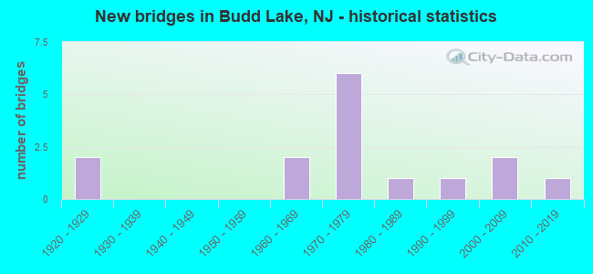
- New bridges - historical statistics
- 21920-1929
- 21960-1969
- 61970-1979
- 11980-1989
- 11990-1999
- 22000-2009
- 12010-2019
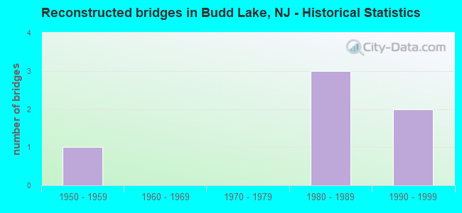
- Reconstructed bridges - Historical Statistics
- 11950-1959
- 01960-1969
- 01970-1979
- 31980-1989
- 21990-1999
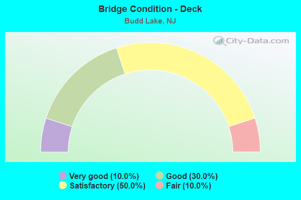
- Bridge Condition - Deck
- 10.0%Very good
- 30.0%Good
- 50.0%Satisfactory
- 10.0%Fair
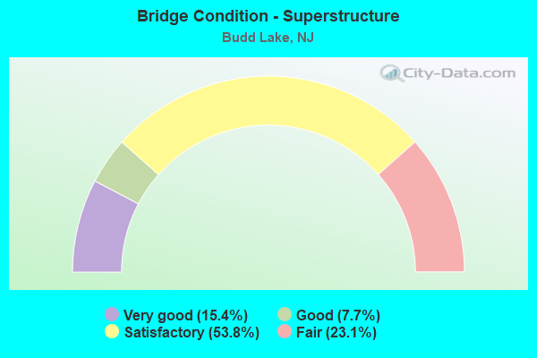
- Bridge Condition - Superstructure
- 15.4%Very good
- 7.7%Good
- 53.8%Satisfactory
- 23.1%Fair
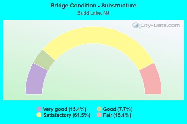
- Bridge Condition - Substructure
- 15.4%Very good
- 7.7%Good
- 61.5%Satisfactory
- 15.4%Fair
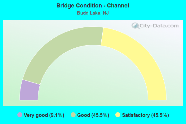
- Bridge Condition - Channel
- 9.1%Very good
- 45.5%Good
- 45.5%Satisfactory
Find on map >> Show street view
Structure Number: 1401047, Location: .6MI.N.WATERLOO VALLEY RD (Lat: 40.908750, Lng: -74.772081), Route carried "on" structure: Other road , Year Built: 1968, Year Reconstructed: 1996, Status: Open, Structure Length: 2.13m (6.99ft), Average Daily Traffic: 91 (year 2021), Truck Traffic: 5%, Average Future Daily Traffic: 111 (year 2041), Design Load: HS 25 or greater, Features Intersected: MUSCONETCONG RIVER, Facility Carried by Structure: KINNY ROAD
Minimum Vertical Clearance: 30+ m (98+ ft), Kilometerpoint: 0.000, Lanes on structure: 2, Owner: County Highway Agency, Approaching Roadway Width: 6.4m (21.0ft), Material/Design: Steel, Design/Construction: Truss - Thru, Number Of Spans In Main Unit: 1, Length of Maximum Span: 19.8m (65.0ft), Curb-To-Curb Width: 7.9m (25.9ft), Out-to-Out Width: 8.4m (27.6ft)
Condition: Deck: Very good, Superstructure: Good, Substructure: Satisfactory, Channel: Good, Operating Rating: 42.6 metric tons, Method Used To Determine Operating Rating: Load Factor (LF), Inventory Rating: 25.4 metric tons, Method Used To Determine Inventory Rating: Load Factor (LF), Structural Evaluation: Equal to present minimum criteria, Deck Geometry: Equal to present minimum criteria, Waterway Adequacy: Better than present minimum criteria, Approach Roadway Alignment: Equal to present minimum criteria, Designated Inspection Frequency: Every 24 months, Critical Feature Inspection Frequency: Every 24 months, Inspection Date: August 2021, Critical Feature Inspection Date: August 2021, Deck Structure Type: Concrete Cast-file-Place, Wearing Surface/Protective System: Wearing Surface: Monolithic Concrete, Deck Protection: Epoxy Coated Reinforcing
Find on map >> Show street view
Structure Number: 1401075, Location: .3 MI NORTH OF RT 46 (Lat: 40.872881, Lng: -74.737761), Route carried "on" structure: City street , Year Built: 1986, Status: Open, Structure Length: 0.98m (3.22ft), Average Daily Traffic: 5,192 (year 2021), Truck Traffic: 3%, Average Future Daily Traffic: 6,336 (year 2041), Design Load: HS 20+Mod, Features Intersected: TRIBUTARY TO BUDD LAKE, Facility Carried by Structure: SAND SHORE ROAD
Minimum Vertical Clearance: 30+ m (98+ ft), Kilometerpoint: 0.000, Lanes on structure: 2, Owner: County Highway Agency, Approaching Roadway Width: 9.1m (29.9ft), Skew: 1 degrees, Material/Design: Prestressed concrete, Design/Construction: Slab, Number Of Spans In Main Unit: 1, Length of Maximum Span: 9.4m (30.8ft), Curb or Sidewalk Widths: Left: 0.9m (3.0ft), Right: 0.4m (1.3ft), Curb-To-Curb Width: 9.0m (29.5ft), Out-to-Out Width: 10.9m (35.8ft)
Condition: Deck: Satisfactory, Superstructure: Satisfactory, Substructure: Good, Channel: Good, Operating Rating: 62.6 metric tons, Method Used To Determine Operating Rating: Load Factor (LF), Inventory Rating: 37.2 metric tons, Method Used To Determine Inventory Rating: Load Factor (LF), Structural Evaluation: Equal to present minimum criteria, Deck Geometry: High priority of replacement, Waterway Adequacy: Meets minimum limits, Approach Roadway Alignment: Equal to present desirable criteria, Length Of Structure Improvement: 0.98m (3.22ft), Designated Inspection Frequency: Every 24 months, Underwater Inspection Frequency: Every 24 months, Inspection Date: July 2021, Underwater Inspection Date: August 2021, Bridge Improvement Cost: $22,000, Roadway Improvement Cost: $3,000, Total Project Cost: $37,000 ( Estimate for 2021), Deck Structure Type: Concrete Precast Panels, Wearing Surface/Protective System: Wearing Surface: Bituminous
Find on map >> Show street view
Structure Number: 1401083, Location: 50 feet east of US 206 (Lat: 40.863139, Lng: -74.696311), Route carried "on" structure: City street , Year Built: 2002, Status: Open, Structure Length: 1.65m (5.41ft), Average Daily Traffic: 166 (year 2021), Truck Traffic: 1%, Average Future Daily Traffic: 203 (year 2041), Design Load: HS 25 or greater, Features Intersected: CONLON POND BROOK, Facility Carried by Structure: CHESTNUT WAY
Minimum Vertical Clearance: 30+ m (98+ ft), Kilometerpoint: 0.000, Lanes on structure: 2, Owner: County Highway Agency, Approaching Roadway Width: 9.1m (29.9ft), Material/Design: Steel, Design/Construction: Truss - Deck, Number Of Spans In Main Unit: 1, Length of Maximum Span: 14.9m (48.9ft), Curb or Sidewalk Widths: Left: 0.0m, Right: 1.2m (3.9ft), Curb-To-Curb Width: 10.4m (34.1ft), Out-to-Out Width: 10.7m (35.1ft)
Condition: Deck: Good, Superstructure: Satisfactory, Substructure: Satisfactory, Channel: Satisfactory, Operating Rating: 63.5 metric tons, Method Used To Determine Operating Rating: Load Factor (LF), Inventory Rating: 32.7 metric tons, Method Used To Determine Inventory Rating: Load Factor (LF), Structural Evaluation: Equal to present minimum criteria, Deck Geometry: Better than present minimum criteria, Waterway Adequacy: Better than present minimum criteria, Approach Roadway Alignment: Better than present minimum criteria, Designated Inspection Frequency: Every 24 months, Critical Feature Inspection Frequency: Every 24 months, Inspection Date: July 2021, Critical Feature Inspection Date: July 2021, Deck Structure Type: Concrete Cast-file-Place, Wearing Surface/Protective System: Wearing Surface: Monolithic Concrete, Deck Protection: Epoxy Coated Reinforcing
Find on map >> Show street view
Structure Number: 1401103, Location: 4 MI. E. OF JCT. 46 & 57 (Lat: 40.862969, Lng: -74.754519), Route carried "on" structure: County highway , Year Built: 2005, Status: Open, Structure Length: 0.64m (2.10ft), Average Daily Traffic: 668 (year 2021), Truck Traffic: 1%, Average Future Daily Traffic: 816 (year 2041), Design Load: HS 20+Mod, Features Intersected: S. BR. OF RARITAN RIVER, Facility Carried by Structure: MANOR HOUSE ROAD
Minimum Vertical Clearance: 30+ m (98+ ft), Kilometerpoint: 0.000, Lanes on structure: 2, Owner: County Highway Agency, Approaching Roadway Width: 7.9m (25.9ft), Skew: 1 degrees, Material/Design: Concrete, Design/Construction: Arch - Deck, Number Of Spans In Main Unit: 1, Length of Maximum Span: 6.4m (21.0ft), Curb or Sidewalk Widths: Left: 0.0m, Right: 1.5m (4.9ft), Curb-To-Curb Width: 7.9m (25.9ft), Out-to-Out Width: 9.2m (30.2ft)
Condition: Superstructure: Very good, Substructure: Very good, Channel: Good, Operating Rating: 54.4 metric tons, Method Used To Determine Operating Rating: Load Factor (LF), Inventory Rating: 32.7 metric tons, Method Used To Determine Inventory Rating: Load Factor (LF), Structural Evaluation: Equal to present desirable criteria, Deck Geometry: Somewhat better than minimum adequacy, Waterway Adequacy: Equal to present minimum criteria, Approach Roadway Alignment: Better than present minimum criteria, Designated Inspection Frequency: Every 24 months, Underwater Inspection Frequency: Every 24 months, Inspection Date: July 2021, Underwater Inspection Date: August 2021
Find on map >> Show street view
Structure Number: 1401107, Location: 2.9 MI WEST OF CO RT 613 (Lat: 40.843189, Lng: -74.752250), Route carried "on" structure: City street , Year Built: 2018, Status: Open, Structure Length: 1.10m (3.61ft), Average Daily Traffic: 953 (year 2020), Truck Traffic: 1%, Average Future Daily Traffic: 1,163 (year 2040), Design Load: HL 93, Features Intersected: S. BRANCH RARITAN RIVER, Facility Carried by Structure: FLANDERS-DRAKESTOW
Minimum Vertical Clearance: 30+ m (98+ ft), Kilometerpoint: 0.000, Lanes on structure: 2, Owner: County Highway Agency, Approaching Roadway Width: 9.1m (29.9ft), Material/Design: Concrete, Design/Construction: Arch - Deck, Number Of Spans In Main Unit: 2, Length of Maximum Span: 4.9m (16.1ft), Curb-To-Curb Width: 9.1m (29.9ft), Out-to-Out Width: 10.6m (34.8ft)
Condition: Superstructure: Very good, Substructure: Very good, Channel: Very good, Operating Rating: 73.5 metric tons, Method Used To Determine Operating Rating: Field evaluation and documented engineering judgment, Inventory Rating: 44.5 metric tons, Method Used To Determine Inventory Rating: Field evaluation and documented engineering judgment, Structural Evaluation: Equal to present desirable criteria, Deck Geometry: Equal to present minimum criteria, Waterway Adequacy: Better than present minimum criteria, Approach Roadway Alignment: Equal to present minimum criteria, Length Of Structure Improvement: 1.65m (5.41ft), Designated Inspection Frequency: Every 24 months, Inspection Date: July 2020, Bridge Improvement Cost: $756,000, Roadway Improvement Cost: $76,000, Total Project Cost: $1,074,000 ( Estimate for 2015)
Find on map >> Show street view
Structure Number: 1401112, Location: 1.3 M WEST OF CO RT 612 (Lat: 40.834219, Lng: -74.738889), Route carried "on" structure: City street , Year Built: 1960, Status: Open, Structure Length: 1.43m (4.69ft), Average Daily Traffic: 3,542 (year 2021), Truck Traffic: 3%, Average Future Daily Traffic: 4,321 (year 2041), Design Load: HS 20, Features Intersected: S BRANCH RARITAN RIVER, Facility Carried by Structure: RIVER ROAD
Minimum Vertical Clearance: 30+ m (98+ ft), Kilometerpoint: 1.979, Lanes on structure: 2, Owner: County Highway Agency, Approaching Roadway Width: 9.8m (32.2ft), Skew: 5 degrees, Material/Design: Steel, Design/Construction: Arch - Deck, Number Of Spans In Main Unit: 2, Length of Maximum Span: 6.4m (21.0ft), Curb-To-Curb Width: 9.7m (31.8ft), Out-to-Out Width: 10.6m (34.8ft)
Condition: Superstructure: Fair, Substructure: Satisfactory, Channel: Satisfactory, Structural Evaluation: Somewhat better than minimum adequacy, Deck Geometry: Meets minimum limits, Waterway Adequacy: Better than present minimum criteria, Approach Roadway Alignment: Equal to present minimum criteria, Designated Inspection Frequency: Every 24 months, Inspection Date: July 2021
Find on map >> Show street view
Structure Number: 1401114, Location: 50FEET WEST OF RIVER ROAD (Lat: 40.829311, Lng: -74.723919), Route carried "on" structure: City street , Year Built: 1994, Status: Open, Structure Length: 3.17m (10.40ft), Average Daily Traffic: 2,155 (year 2021), Truck Traffic: 3%, Average Future Daily Traffic: 2,630 (year 2041), Design Load: HS 25 or greater, Features Intersected: SO.BRANCH RARITAN RIVER, Facility Carried by Structure: DRAKESTOWN ROAD
Minimum Vertical Clearance: 30+ m (98+ ft), Kilometerpoint: 8.047, Lanes on structure: 2, Owner: County Highway Agency, Approaching Roadway Width: 7.9m (25.9ft), Skew: 1 degrees, Material/Design: Steel, Design/Construction: Truss - Thru, Number Of Spans In Main Unit: 1, Length of Maximum Span: 30.8m (101.0ft), Curb or Sidewalk Widths: Left: 0.3m (1.0ft), Right: 0.3m (1.0ft), Curb-To-Curb Width: 8.0m (26.2ft), Out-to-Out Width: 8.6m (28.2ft)
Condition: Deck: Satisfactory, Superstructure: Satisfactory, Substructure: Satisfactory, Channel: Satisfactory, Operating Rating: 58.1 metric tons, Method Used To Determine Operating Rating: Load Factor (LF), Inventory Rating: 34.5 metric tons, Method Used To Determine Inventory Rating: Load Factor (LF), Structural Evaluation: Equal to present minimum criteria, Deck Geometry: High priority of corrective action, Waterway Adequacy: Equal to present minimum criteria, Approach Roadway Alignment: Equal to present minimum criteria, Length Of Structure Improvement: 3.17m (10.40ft), Designated Inspection Frequency: Every 24 months, Critical Feature Inspection Frequency: Every 24 months, Inspection Date: August 2021, Critical Feature Inspection Date: August 2021, Bridge Improvement Cost: $1,691,000, Roadway Improvement Cost: $254,000, Total Project Cost: $2,626,000 ( Estimate for 2021), Deck Structure Type: Concrete Cast-file-Place, Wearing Surface/Protective System: Wearing Surface: Monolithic Concrete, Deck Protection: Epoxy Coated Reinforcing
Find on map >> Show street view
Structure Number: 1401127, Location: 1.7 MI W OF CTY RT 612 (Lat: 40.837811, Lng: -74.745331), Route carried "on" structure: City street , Year Built: 1978, Status: Open, Structure Length: 0.94m (3.08ft), Average Daily Traffic: 483 (year 2021), Truck Traffic: 1%, Average Future Daily Traffic: 590 (year 2041), Features Intersected: SOUTH BR.RARITAN RIVER, Facility Carried by Structure: STEPHENS MILL ROAD
Minimum Vertical Clearance: 30+ m (98+ ft), Kilometerpoint: 0.000, Lanes on structure: 2, Owner: County Highway Agency, Approaching Roadway Width: 5.8m (19.0ft), Material/Design: Steel, Design/Construction: Stringer/Multi-beam, Number Of Spans In Main Unit: 1, Length of Maximum Span: 9.1m (29.9ft), Curb-To-Curb Width: 5.5m (18.0ft), Out-to-Out Width: 5.7m (18.7ft)
Condition: Deck: Satisfactory, Superstructure: Fair, Substructure: Satisfactory, Channel: Satisfactory, Inventory Rating: 62.6 metric tons, Method Used To Determine Inventory Rating: Load Factor (LF), Structural Evaluation: Somewhat better than minimum adequacy, Deck Geometry: High priority of replacement, Waterway Adequacy: Better than present minimum criteria, Approach Roadway Alignment: Meets minimum limits, Length Of Structure Improvement: 0.94m (3.08ft), Designated Inspection Frequency: Every 24 months, Inspection Date: July 2021, Bridge Improvement Cost: $138,000, Roadway Improvement Cost: $9,000, Total Project Cost: $310,000 ( Estimate for 2021), Deck Structure Type: Corrugated Steel, Wearing Surface/Protective System: Wearing Surface: Bituminous
Find on map >> Show street view
Structure Number: 1407156, Location: 3.6MI WEST OF I-80 JCT (Lat: 40.859350, Lng: -74.760889), Route carried "on" structure: US 46, Year Built: 1921, Year Reconstructed: 1964, Status: Open, Structure Length: 1.04m (3.41ft), Average Daily Traffic: 24,562 (year 2021), Truck Traffic: 4%, Average Future Daily Traffic: 29,474 (year 2041), Features Intersected: SOUTH BR RARITAN RIVER
Minimum Vertical Clearance: 30+ m (98+ ft), Kilometerpoint: 41.650, Lanes on structure: 4, Base Highway Network: Yes, Owner: State Highway Agency, Approaching Roadway Width: 14.0m (45.9ft), Skew: 4 degrees, Material/Design: Steel, Design/Construction: Stringer/Multi-beam, Number Of Spans In Main Unit: 1, Length of Maximum Span: 9.8m (32.2ft), Curb or Sidewalk Widths: Left: 1.8m (5.9ft), Right: 1.7m (5.6ft), Curb-To-Curb Width: 14.0m (45.9ft), Out-to-Out Width: 18.3m (60.0ft)
Condition: Deck: Fair, Superstructure: Fair, Substructure: Fair, Channel: Satisfactory, Operating Rating: 80.7 metric tons, Method Used To Determine Operating Rating: Load Factor (LF), Inventory Rating: 20.0 metric tons, Method Used To Determine Inventory Rating: Load Factor (LF), Structural Evaluation: Somewhat better than minimum adequacy, Deck Geometry: High priority of replacement, Waterway Adequacy: Superior to present desirable criteria, Approach Roadway Alignment: Equal to present desirable criteria, Length Of Structure Improvement: 1.04m (3.41ft), Designated Inspection Frequency: Every 24 months, Inspection Date: May 2021, Bridge Improvement Cost: $141,000, Roadway Improvement Cost: $89,000, Total Project Cost: $634,000 ( Estimate for 2021), Deck Structure Type: Concrete Cast-file-Place, Wearing Surface/Protective System: Wearing Surface: Bituminous
Find on map >> Show street view
Structure Number: 1417158, Location: 2.6 MI SOUTH OF I-80 JCT (Lat: 40.855761, Lng: -74.701211), Route carried "on" structure: US 206, Year Built: 1928, Year Reconstructed: 1998, Status: Open, Structure Length: 0.73m (2.40ft), Average Daily Traffic: 27,415 (year 2021), Truck Traffic: 4%, Average Future Daily Traffic: 33,451 (year 2041), Design Load: HS 25 or greater, Features Intersected: SO BRANCH OF RARITAN RIV
Minimum Vertical Clearance: 30+ m (98+ ft), Kilometerpoint: 149.074, Lanes on structure: 3, Base Highway Network: Yes, Owner: State Highway Agency, Approaching Roadway Width: 14.6m (47.9ft), Skew: 4 degrees, Material/Design: Concrete, Design/Construction: Slab, Number Of Spans In Main Unit: 1, Length of Maximum Span: 6.1m (20.0ft), Curb-To-Curb Width: 14.8m (48.6ft), Out-to-Out Width: 15.7m (51.5ft)
Condition: Deck: Satisfactory, Superstructure: Satisfactory, Substructure: Fair, Channel: Good, Operating Rating: 44.5 metric tons, Method Used To Determine Operating Rating: Load Factor (LF), Inventory Rating: 26.3 metric tons, Method Used To Determine Inventory Rating: Load Factor (LF), Structural Evaluation: Somewhat better than minimum adequacy, Deck Geometry: Equal to present minimum criteria, Waterway Adequacy: Equal to present desirable criteria, Approach Roadway Alignment: Better than present minimum criteria, Length Of Structure Improvement: 0.70m (2.30ft), Designated Inspection Frequency: Every 24 months, Inspection Date: March 2021, Bridge Improvement Cost: $35,000, Total Project Cost: $35,000 ( Estimate for 2021), Deck Structure Type: Concrete Cast-file-Place, Wearing Surface/Protective System: Wearing Surface: Bituminous
Find on map >> Show street view
Structure Number: 190615, Location: 2.3 MI W OF I-80 EXIT 25 (Lat: 40.915631, Lng: -74.765511), Route carried "on" structure: Interstate 80, Year Built: 1973, Year Reconstructed: 1986, Status: Open, Structure Length: 3.54m (11.61ft), Average Daily Traffic: 37,935 (year 2021), Truck Traffic: 14%, Average Future Daily Traffic: 46,288 (year 2041), Design Load: HS 20, Features Intersected: WATERLOO ROAD (CR 604)
Minimum Vertical Clearance: 30+ m (98+ ft), Kilometerpoint: 36.854, Lanes on structure: 3, Lanes under structure: 2, Base Highway Network: Yes, Owner: State Highway Agency, Approaching Roadway Width: 16.5m (54.1ft), Skew: 1 degrees, Material/Design: Steel, Design/Construction: Stringer/Multi-beam, Number Of Spans In Main Unit: 1, Length of Maximum Span: 33.5m (109.9ft), Curb or Sidewalk Widths: Left: 0.2m (0.7ft), Right: 0.2m (0.7ft), Curb-To-Curb Width: 16.5m (54.1ft), Out-to-Out Width: 17.6m (57.7ft)
Condition: Deck: Good, Superstructure: Satisfactory, Substructure: Satisfactory, Operating Rating: 88.9 metric tons, Method Used To Determine Operating Rating: Load Factor (LF), Inventory Rating: 53.5 metric tons, Method Used To Determine Inventory Rating: Load Factor (LF), Structural Evaluation: Equal to present minimum criteria, Deck Geometry: Equal to present minimum criteria, Underclear: Meets minimum limits, Approach Roadway Alignment: Better than present minimum criteria, Designated Inspection Frequency: Every 24 months, Inspection Date: May 2021, Deck Structure Type: Concrete Cast-file-Place, Wearing Surface/Protective System: Wearing Surface: Bituminous
Find on map >> Show street view
Structure Number: 1906151, Location: 2.3 MI WEST OF US 206 (Lat: 40.915819, Lng: -74.764850), Route carried "on" structure: Interstate 80, Year Built: 1973, Year Reconstructed: 1986, Status: Open, Structure Length: 3.54m (11.61ft), Average Daily Traffic: 37,935 (year 2021), Truck Traffic: 14%, Average Future Daily Traffic: 46,288 (year 2041), Design Load: HS 20, Features Intersected: WATERLOO ROAD (CR 604)
Minimum Vertical Clearance: 30+ m (98+ ft), Kilometerpoint: 36.854, Lanes on structure: 3, Lanes under structure: 2, Base Highway Network: Yes, Owner: State Highway Agency, Approaching Roadway Width: 16.5m (54.1ft), Skew: 1 degrees, Material/Design: Steel, Design/Construction: Stringer/Multi-beam, Number Of Spans In Main Unit: 1, Length of Maximum Span: 33.5m (109.9ft), Curb or Sidewalk Widths: Left: 0.2m (0.7ft), Right: 0.2m (0.7ft), Curb-To-Curb Width: 16.5m (54.1ft), Out-to-Out Width: 17.6m (57.7ft)
Condition: Deck: Good, Superstructure: Satisfactory, Substructure: Satisfactory, Operating Rating: 86.2 metric tons, Method Used To Determine Operating Rating: Load Factor (LF), Inventory Rating: 51.7 metric tons, Method Used To Determine Inventory Rating: Load Factor (LF), Structural Evaluation: Equal to present minimum criteria, Deck Geometry: Equal to present minimum criteria, Underclear: Meets minimum limits, Approach Roadway Alignment: Better than present minimum criteria, Designated Inspection Frequency: Every 24 months, Inspection Date: May 2021, Deck Structure Type: Concrete Cast-file-Place, Wearing Surface/Protective System: Wearing Surface: Bituminous
Find on map >> Show street view
Structure Number: 1906152, Location: 2.0 MI WEST OF US 206 (Lat: 40.913461, Lng: -74.760611), Route carried "on" structure: Interstate 80, Year Built: 1972, Year Reconstructed: 1985, Status: Open, Structure Length: 7.16m (23.49ft), Average Daily Traffic: 60,319 (year 2021), Truck Traffic: 14%, Average Future Daily Traffic: 73,383 (year 2041), Design Load: HS 20, Features Intersected: MUSCONETCONG RIVER
Minimum Vertical Clearance: 30+ m (98+ ft), Kilometerpoint: 37.353, Lanes on structure: 6, Base Highway Network: Yes, Owner: State Highway Agency, Approaching Roadway Width: 31.4m (103.0ft), Skew: 30 degrees, Material/Design: Steel, Design/Construction: Stringer/Multi-beam, Number Of Spans In Main Unit: 3, Length of Maximum Span: 29.9m (98.1ft), Curb or Sidewalk Widths: Left: 0.2m (0.7ft), Right: 0.2m (0.7ft), Curb-To-Curb Width: 31.4m (103.0ft), Out-to-Out Width: 33.3m (109.3ft)
Condition: Deck: Satisfactory, Superstructure: Satisfactory, Substructure: Satisfactory, Channel: Good, Operating Rating: 64.4 metric tons, Method Used To Determine Operating Rating: Load Factor (LF), Inventory Rating: 38.1 metric tons, Method Used To Determine Inventory Rating: Load Factor (LF), Structural Evaluation: Equal to present minimum criteria, Deck Geometry: Superior to present desirable criteria, Waterway Adequacy: Superior to present desirable criteria, Approach Roadway Alignment: Equal to present desirable criteria, Designated Inspection Frequency: Every 24 months, Inspection Date: April 2021, Deck Structure Type: Concrete Cast-file-Place, Wearing Surface/Protective System: Wearing Surface: Bituminous
Find on map >> Show street view
Structure Number: 190615, Location: 2.3 MI W OF I-80 EXIT 25 (Lat: 40.915631, Lng: -74.765511), Route carried "under" structure: County highway 604, Year Built: 1973, Structure Length: 0. m, Average Daily Traffic: 3,461 (year 2021), Truck Traffic: 3%, Features Intersected: WATERLOO ROAD (CR 604), Facility Carried by Structure: I-80 EB
Minimum Vertical Clearance: 4.37m (14.34ft), Kilometerpoint: 0.451, Lanes on structure: 3, Lanes under structure: 2, Material/Design: Steel, Design/Construction: Stringer/Multi-beam, Length of Maximum Span: 33.5m (109.9ft)
Find on map >> Show street view
Structure Number: 1906151, Location: 2.3 MI WEST OF US 206 (Lat: 40.915819, Lng: -74.764850), Route carried "under" structure: County highway 604, Year Built: 1973, Structure Length: 0. m, Average Daily Traffic: 3,461 (year 2021), Truck Traffic: 3%, Features Intersected: WATERLOO ROAD (CR 604), Facility Carried by Structure: I-80 WB
Minimum Vertical Clearance: 4.40m (14.44ft), Kilometerpoint: 0.451, Lanes on structure: 3, Lanes under structure: 2, Material/Design: Steel, Design/Construction: Stringer/Multi-beam, Length of Maximum Span: 33.5m (109.9ft)