Bridge Statistics for Buena Vista, Colorado (CO)
Condition, Traffic, Stress, Structural Evaluation, Project Costs
- National Bridge Inventory (NBI) Statistics
- 12Number of bridges
- 43ft / 12.6mTotal length
- $107,000Total costs
- 24,609Total average daily traffic
- 1,004Total average daily truck traffic
- 32,066Total future (year 2038) average daily traffic
- National Bridge Inventory (NBI) Registered Bridges for Buena Vista
- No street view available for this location
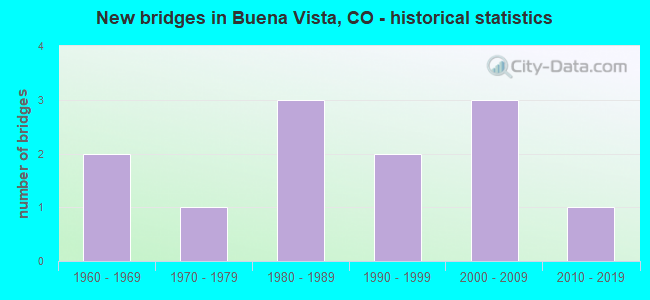
- New bridges - historical statistics
- 21960-1969
- 11970-1979
- 31980-1989
- 21990-1999
- 32000-2009
- 12010-2019


- Bridge Condition - Deck
- 50.0%Good
- 37.5%Satisfactory
- 12.5%Fair

- Bridge Condition - Superstructure
- 25.0%Very good
- 37.5%Good
- 37.5%Satisfactory

- Bridge Condition - Substructure
- 75.0%Good
- 25.0%Fair

- Bridge Condition - Channel
- 33.3%Very good
- 41.7%Good
- 25.0%Satisfactory

- Bridge Condition - Culverts
- 25.0%Good
- 75.0%Satisfactory
Find on map >> Show street view
Structure Number: B.V.-CEDAR-A, Location: .1 MI E of SH 24 (Lat: 38.840953, Lng: -106.131772), Route carried "on" structure: City street , Year Built: 1988, Status: Open, Structure Length: 1.02m (3.35ft), Average Daily Traffic: 165 (year 2018), Truck Traffic: 2%, Average Future Daily Traffic: 221 (year 2038), Design Load: HS 20, Features Intersected: COTTONWOOD CREEK, Facility Carried by Structure: CEDAR STREET
Minimum Vertical Clearance: 30+ m (98+ ft), Kilometerpoint: 0.042, Lanes on structure: 2, Owner: Town or Township Highway Agency, Approaching Roadway Width: 9.1m (29.9ft), Skew: 4 degrees, Material/Design: Concrete, Design/Construction: Frame, Number Of Spans In Main Unit: 1, Length of Maximum Span: 9.4m (30.8ft), Curb or Sidewalk Widths: Left: 0.0m, Right: 1.5m (4.9ft), Curb-To-Curb Width: 9.0m (29.5ft), Out-to-Out Width: 10.8m (35.4ft)
Condition: Deck: Satisfactory, Superstructure: Satisfactory, Substructure: Good, Channel: Very good, Operating Rating: 54.4 metric tons, Method Used To Determine Operating Rating: Load Factor (LF), Inventory Rating: 32.7 metric tons, Method Used To Determine Inventory Rating: Load Factor (LF), Structural Evaluation: Equal to present minimum criteria, Deck Geometry: Equal to present minimum criteria, Waterway Adequacy: Better than present minimum criteria, Approach Roadway Alignment: Equal to present desirable criteria, Designated Inspection Frequency: Every 24 months, Inspection Date: March 2020, Deck Structure Type: Other, Wearing Surface/Protective System: Wearing Surface: Bituminous
Find on map >> Show street view
Structure Number: B.V.-JAMES ST., Location: .1 MI W of Waters Ave (Lat: 38.844639, Lng: -106.139528), Route carried "on" structure: City street , Year Built: 1968, Status: Open, Structure Length: 0.67m (2.20ft), Average Daily Traffic: 550 (year 2018), Truck Traffic: 2%, Average Future Daily Traffic: 736 (year 2038), Features Intersected: COTTONWOOD CREEK, Facility Carried by Structure: JAMES STREET
Minimum Vertical Clearance: 30+ m (98+ ft), Kilometerpoint: 0.547, Lanes on structure: 2, Owner: Town or Township Highway Agency, Approaching Roadway Width: 7.6m (24.9ft), Material/Design: Steel, Design/Construction: Stringer/Multi-beam, Number Of Spans In Main Unit: 1, Length of Maximum Span: 6.1m (20.0ft), Curb-To-Curb Width: 5.9m (19.4ft), Out-to-Out Width: 6.1m (20.0ft)
Condition: Deck: Fair, Superstructure: Satisfactory, Substructure: Fair, Channel: Satisfactory, Operating Rating: 32.1 metric tons, Method Used To Determine Operating Rating: Load Factor (LF), Inventory Rating: 19.2 metric tons, Method Used To Determine Inventory Rating: Load Factor (LF), Structural Evaluation: Somewhat better than minimum adequacy, Deck Geometry: High priority of replacement, Waterway Adequacy: Better than present minimum criteria, Approach Roadway Alignment: Somewhat better than minimum adequacy, Length Of Structure Improvement: 0.67m (2.20ft), Designated Inspection Frequency: Every 24 months, Inspection Date: March 2020, Bridge Improvement Cost: $98,000, Roadway Improvement Cost: $10,000, Total Project Cost: $107,000 ( Estimate for 2020), Deck Structure Type: Corrugated Steel, Wearing Surface/Protective System: Wearing Surface: Bituminous
Find on map >> Show street view
Structure Number: B.V.-PLEASANT-A, Location: .1 MI N OF PRINCETON AVE (Lat: 38.844531, Lng: -106.137042), Route carried "on" structure: City street , Year Built: 1988, Status: Open, Structure Length: 0.91m (2.99ft), Average Daily Traffic: 1,527 (year 2018), Truck Traffic: 5%, Average Future Daily Traffic: 2,046 (year 2038), Design Load: HS 20, Features Intersected: COTTONWOOD CREEK, Facility Carried by Structure: PLEASANT AVENUE
Minimum Vertical Clearance: 30+ m (98+ ft), Kilometerpoint: 0.953, Lanes on structure: 2, Owner: Town or Township Highway Agency, Approaching Roadway Width: 10.7m (35.1ft), Skew: 1 degrees, Material/Design: Concrete, Design/Construction: Frame, Number Of Spans In Main Unit: 1, Length of Maximum Span: 8.6m (28.2ft), Curb-To-Curb Width: 10.4m (34.1ft), Out-to-Out Width: 10.8m (35.4ft)
Condition: Deck: Satisfactory, Superstructure: Satisfactory, Substructure: Good, Channel: Very good, Operating Rating: 54.4 metric tons, Method Used To Determine Operating Rating: Load Factor (LF), Inventory Rating: 32.7 metric tons, Method Used To Determine Inventory Rating: Load Factor (LF), Structural Evaluation: Equal to present minimum criteria, Deck Geometry: Equal to present minimum criteria, Waterway Adequacy: Equal to present minimum criteria, Approach Roadway Alignment: Equal to present desirable criteria, Designated Inspection Frequency: Every 24 months, Inspection Date: March 2020, Deck Structure Type: Other, Wearing Surface/Protective System: Wearing Surface: Bituminous
Find on map >> Show street view
Structure Number: B.V.-RAILROAD, Location: .2 MI S OF CR 306 (Lat: 38.840217, Lng: -106.129786), Route carried "on" structure: City street , Year Built: 1979, Status: Open, Structure Length: 0.76m (2.49ft), Average Daily Traffic: 2,679 (year 2018), Truck Traffic: 5%, Average Future Daily Traffic: 3,590 (year 2038), Features Intersected: COTTONWOOD CREEK, Facility Carried by Structure: RAILROAD STREET
Minimum Vertical Clearance: 30+ m (98+ ft), Kilometerpoint: 0.950, Lanes on structure: 2, Owner: Town or Township Highway Agency, Approaching Roadway Width: 9.1m (29.9ft), Skew: 4 degrees, Material/Design: Concrete, Design/Construction: Culvert, Number Of Spans In Main Unit: 2, Length of Maximum Span: 3.6m (11.8ft), Curb or Sidewalk Widths: Left: 2.0m (6.6ft), Right: 0.0m, Out-to-Out Width: 13.2m (43.3ft)
Condition: Channel: Satisfactory, Culverts: Satisfactory, Operating Rating: 36.3 metric tons, Method Used To Determine Operating Rating: Field evaluation and documented engineering judgment, Inventory Rating: 32.7 metric tons, Method Used To Determine Inventory Rating: Field evaluation and documented engineering judgment, Structural Evaluation: Equal to present minimum criteria, Waterway Adequacy: Better than present minimum criteria, Approach Roadway Alignment: Equal to present desirable criteria, Designated Inspection Frequency: Every 24 months, Inspection Date: March 2020
Find on map >> Show street view
Structure Number: CHA338-00.85A, Location: .2 MI NW OF CR 306 (Lat: 38.826253, Lng: -106.183400), Route carried "on" structure: County highway , Year Built: 2005, Status: Open, Structure Length: 0.75m (2.46ft), Average Daily Traffic: 208 (year 2018), Truck Traffic: 2%, Average Future Daily Traffic: 279 (year 2038), Design Load: HS 20+Mod, Features Intersected: COTTONWOOD CREEK, Facility Carried by Structure: COUNTY ROAD 338
Minimum Vertical Clearance: 30+ m (98+ ft), Kilometerpoint: 1.711, Lanes on structure: 2, Owner: County Highway Agency, Approaching Roadway Width: 8.5m (27.9ft), Skew: 1 degrees, Material/Design: Aluminum, Iron, Design/Construction: Culvert, Number Of Spans In Main Unit: 1, Length of Maximum Span: 7.5m (24.6ft), Curb-To-Curb Width: 8.7m (28.5ft), Out-to-Out Width: 9.7m (31.8ft)
Condition: Channel: Good, Culverts: Satisfactory, Inventory Rating: 54.2 metric tons, Method Used To Determine Inventory Rating: Load Factor (LF), Structural Evaluation: Equal to present minimum criteria, Deck Geometry: Equal to present minimum criteria, Waterway Adequacy: Equal to present desirable criteria, Approach Roadway Alignment: Equal to present minimum criteria, Designated Inspection Frequency: Every 24 months, Inspection Date: March 2020
Find on map >> Show street view
Structure Number: CHA340-00.08A, Location: .1 MI NW OF CR 306 (Lat: 38.817483, Lng: -106.199083), Route carried "on" structure: County highway , Year Built: 1991, Status: Open, Structure Length: 0.98m (3.22ft), Average Daily Traffic: 112 (year 2018), Average Future Daily Traffic: 151 (year 2038), Design Load: HS 20, Features Intersected: COTTONWOOD CREEK, Facility Carried by Structure: COUNTY ROAD 340
Minimum Vertical Clearance: 30+ m (98+ ft), Kilometerpoint: 0.261, Lanes on structure: 2, Owner: County Highway Agency, Approaching Roadway Width: 6.7m (22.0ft), Material/Design: Wood or Timber, Design/Construction: Slab, Number Of Spans In Main Unit: 1, Length of Maximum Span: 9.1m (29.9ft), Curb-To-Curb Width: 8.5m (27.9ft), Out-to-Out Width: 9.2m (30.2ft)
Condition: Deck: Good, Superstructure: Good, Substructure: Good, Channel: Good, Operating Rating: 50.1 metric tons, Method Used To Determine Operating Rating: Allowable Stress (AS), Inventory Rating: 35.1 metric tons, Method Used To Determine Inventory Rating: Allowable Stress (AS), Structural Evaluation: Better than present minimum criteria, Deck Geometry: Equal to present minimum criteria, Waterway Adequacy: Equal to present desirable criteria, Approach Roadway Alignment: Somewhat better than minimum adequacy, Designated Inspection Frequency: Every 24 months, Inspection Date: March 2020, Deck Structure Type: Wood or Timber, Wearing Surface/Protective System: Wearing Surface: Bituminous
Find on map >> Show street view
Structure Number: CHA340-02.30A, Location: .5 MI NW OF CR 306 (Lat: 38.832786, Lng: -106.185636), Route carried "on" structure: County highway , Year Built: 2001, Status: Open, Structure Length: 0.88m (2.89ft), Average Daily Traffic: 546 (year 2018), Truck Traffic: 2%, Average Future Daily Traffic: 732 (year 2038), Features Intersected: NORTH COTTONWOOD CREEK, Facility Carried by Structure: COUNTY RD 340
Minimum Vertical Clearance: 30+ m (98+ ft), Kilometerpoint: 1.582, Lanes on structure: 2, Owner: County Highway Agency, Approaching Roadway Width: 9.1m (29.9ft), Skew: 2 degrees, Material/Design: Steel, Design/Construction: Stringer/Multi-beam, Number Of Spans In Main Unit: 1, Length of Maximum Span: 8.1m (26.6ft), Curb-To-Curb Width: 9.2m (30.2ft), Out-to-Out Width: 9.3m (30.5ft)
Condition: Deck: Satisfactory, Superstructure: Good, Substructure: Good, Channel: Good, Operating Rating: 47.8 metric tons, Method Used To Determine Operating Rating: Load Factor (LF), Inventory Rating: 28.6 metric tons, Method Used To Determine Inventory Rating: Load Factor (LF), Structural Evaluation: Better than present minimum criteria, Deck Geometry: Equal to present minimum criteria, Waterway Adequacy: Equal to present desirable criteria, Approach Roadway Alignment: Equal to present desirable criteria, Designated Inspection Frequency: Every 24 months, Inspection Date: March 2020, Deck Structure Type: Concrete Cast-file-Place, Wearing Surface/Protective System: Wearing Surface: Monolithic Concrete, Deck Protection: Epoxy Coated Reinforcing
Find on map >> Show street view
Structure Number: CHA350-01.25A, Location: 1.0 MI WESTOF SH 24 (Lat: 38.846819, Lng: -106.151047), Route carried "on" structure: County highway , Year Built: 1997, Status: Open, Structure Length: 0.90m (2.95ft), Average Daily Traffic: 2,528 (year 2018), Truck Traffic: 5%, Average Future Daily Traffic: 3,387 (year 2038), Features Intersected: COTTONWOOD CREEK, Facility Carried by Structure: COUNTY ROAD 350
Minimum Vertical Clearance: 30+ m (98+ ft), Kilometerpoint: 2.044, Lanes on structure: 2, Owner: County Highway Agency, Approaching Roadway Width: 9.1m (29.9ft), Skew: 1 degrees, Material/Design: Steel, Design/Construction: Stringer/Multi-beam, Number Of Spans In Main Unit: 1, Length of Maximum Span: 8.4m (27.6ft), Curb-To-Curb Width: 9.1m (29.9ft), Out-to-Out Width: 9.9m (32.5ft)
Condition: Deck: Good, Superstructure: Very good, Substructure: Fair, Channel: Good, Operating Rating: 87.5 metric tons, Method Used To Determine Operating Rating: Load Factor (LF), Inventory Rating: 52.5 metric tons, Method Used To Determine Inventory Rating: Load Factor (LF), Structural Evaluation: Somewhat better than minimum adequacy, Deck Geometry: Meets minimum limits, Waterway Adequacy: Better than present minimum criteria, Approach Roadway Alignment: Equal to present desirable criteria, Designated Inspection Frequency: Every 24 months, Inspection Date: March 2020, Deck Structure Type: Concrete Cast-file-Place, Wearing Surface/Protective System: Wearing Surface: Bituminous
Find on map >> Show street view
Structure Number: CHA350-01.70A, Location: 0.5 MI WEST OF SH 24 (Lat: 38.846858, Lng: -106.144147), Route carried "on" structure: County highway , Year Built: 2001, Status: Open, Structure Length: 0.98m (3.22ft), Average Daily Traffic: 2,389 (year 2018), Truck Traffic: 5%, Average Future Daily Traffic: 3,201 (year 2038), Features Intersected: COTTONWOOD CREEK, Facility Carried by Structure: COUNTY RD 350
Minimum Vertical Clearance: 30+ m (98+ ft), Kilometerpoint: 2.655, Lanes on structure: 2, Owner: County Highway Agency, Approaching Roadway Width: 9.1m (29.9ft), Material/Design: Steel, Design/Construction: Stringer/Multi-beam, Number Of Spans In Main Unit: 1, Length of Maximum Span: 9.1m (29.9ft), Curb-To-Curb Width: 10.4m (34.1ft), Out-to-Out Width: 10.5m (34.4ft)
Condition: Deck: Good, Superstructure: Very good, Substructure: Good, Channel: Very good, Operating Rating: 59.1 metric tons, Method Used To Determine Operating Rating: Load Factor (LF), Inventory Rating: 35.4 metric tons, Method Used To Determine Inventory Rating: Load Factor (LF), Structural Evaluation: Better than present minimum criteria, Deck Geometry: Somewhat better than minimum adequacy, Waterway Adequacy: Better than present minimum criteria, Approach Roadway Alignment: Equal to present desirable criteria, Designated Inspection Frequency: Every 24 months, Inspection Date: March 2020, Deck Structure Type: Concrete Cast-file-Place, Wearing Surface/Protective System: Wearing Surface: Bituminous, Deck Protection: Epoxy Coated Reinforcing
Find on map >> Show street view
Structure Number: CHA361-00.20A, Location: .2 MI N OF CR 306 (Lat: 38.830683, Lng: -106.177581), Route carried "on" structure: County highway , Year Built: 2011, Status: Open, Structure Length: 0.91m (2.99ft), Average Daily Traffic: 768 (year 2018), Average Future Daily Traffic: 1,029 (year 2038), Features Intersected: COTTONWOOD CREEK, Facility Carried by Structure: COUNTY ROAD 361
Minimum Vertical Clearance: 30+ m (98+ ft), Kilometerpoint: 0.272, Lanes on structure: 2, Owner: County Highway Agency, Approaching Roadway Width: 7.3m (24.0ft), Material/Design: Concrete, Design/Construction: Culvert, Number Of Spans In Main Unit: 1, Length of Maximum Span: 9.1m (29.9ft), Curb-To-Curb Width: 11.2m (36.7ft), Out-to-Out Width: 12.8m (42.0ft)
Condition: Channel: Satisfactory, Culverts: Good, Operating Rating: 36.3 metric tons, Method Used To Determine Operating Rating: Field evaluation and documented engineering judgment, Inventory Rating: 32.7 metric tons, Method Used To Determine Inventory Rating: Field evaluation and documented engineering judgment, Structural Evaluation: Better than present minimum criteria, Deck Geometry: Better than present minimum criteria, Waterway Adequacy: Equal to present desirable criteria, Approach Roadway Alignment: Equal to present desirable criteria, Designated Inspection Frequency: Every 24 months, Inspection Date: March 2020
Find on map >> Show street view
Structure Number: CHA371-01.70A, Location: 1.6 MI N OF MAIN STREET (Lat: 38.865872, Lng: -106.138831), Route carried "on" structure: County highway , Year Built: 1987, Status: Open, Structure Length: 2.65m (8.69ft), Average Daily Traffic: 137 (year 2018), Truck Traffic: 2%, Average Future Daily Traffic: 184 (year 2038), Features Intersected: ARKANSAS RIVER, Facility Carried by Structure: COUNTY ROAD 371
Minimum Vertical Clearance: 30+ m (98+ ft), Kilometerpoint: 2.403, Lanes on structure: 2, Owner: County Highway Agency, Approaching Roadway Width: 7.9m (25.9ft), Material/Design: Prestressed concrete, Design/Construction: Stringer/Multi-beam, Number Of Spans In Main Unit: 1, Length of Maximum Span: 25.0m (82.0ft), Curb-To-Curb Width: 8.5m (27.9ft), Out-to-Out Width: 9.3m (30.5ft)
Condition: Deck: Good, Superstructure: Good, Substructure: Good, Channel: Very good, Operating Rating: 36.3 metric tons, Method Used To Determine Operating Rating: Field evaluation and documented engineering judgment, Inventory Rating: 32.7 metric tons, Method Used To Determine Inventory Rating: Field evaluation and documented engineering judgment, Structural Evaluation: Better than present minimum criteria, Deck Geometry: Equal to present minimum criteria, Waterway Adequacy: Equal to present desirable criteria, Approach Roadway Alignment: Equal to present minimum criteria, Designated Inspection Frequency: Every 24 months, Inspection Date: March 2020, Deck Structure Type: Concrete Cast-file-Place, Wearing Surface/Protective System: Wearing Surface: Bituminous, Membrane: Built-up
Find on map >> Show street view
Structure Number: I-12-S, Location: IN BUENA VISTA (Lat: 38.840978, Lng: -106.132131), Route carried "on" structure: US 24A, Year Built: 1969, Status: Open, Structure Length: 1.19m (3.90ft), Average Daily Traffic: 13,000 (year 2020), Truck Traffic: 4%, Average Future Daily Traffic: 16,510 (year 2040), Design Load: HS 20, Features Intersected: COTTONWOOD CREEK, Facility Carried by Structure: US 24 ML
Minimum Vertical Clearance: 30+ m (98+ ft), Kilometerpoint: 106.934, Lanes on structure: 4, Base Highway Network: Yes, Owner: State Highway Agency, Approaching Roadway Width: 20.1m (65.9ft), Skew: 3 degrees, Material/Design: Concrete, Design/Construction: Culvert, Number Of Spans In Main Unit: 3, Length of Maximum Span: 4.4m (14.4ft), Curb or Sidewalk Widths: Left: 2.0m (6.6ft), Right: 1.5m (4.9ft), Curb-To-Curb Width: 20.1m (65.9ft), Out-to-Out Width: 32.9m (107.9ft)
Condition: Channel: Good, Culverts: Satisfactory, Operating Rating: 36.3 metric tons, Method Used To Determine Operating Rating: Field evaluation and documented engineering judgment, Inventory Rating: 32.7 metric tons, Method Used To Determine Inventory Rating: Field evaluation and documented engineering judgment, Structural Evaluation: Equal to present minimum criteria, Deck Geometry: Better than present minimum criteria, Waterway Adequacy: Equal to present desirable criteria, Approach Roadway Alignment: Equal to present desirable criteria, Designated Inspection Frequency: Every 24 months, Inspection Date: April 2021