Bridge Statistics for Buena Vista, Michigan (MI)
Condition, Traffic, Stress, Structural Evaluation, Project Costs
- National Bridge Inventory (NBI) Statistics
- 22Number of bridges
- 256ft / 78.5mTotal length
- 654,504Total average daily traffic
- 59,266Total average daily truck traffic
- National Bridge Inventory (NBI) Registered Bridges for Buena Vista
- No street view available for this location
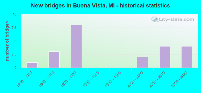
- New bridges - historical statistics
- 11950-1959
- 31960-1969
- 81970-1979
- 22000-2009
- 42010-2019
- 42020-2022
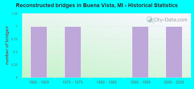
- Reconstructed bridges - Historical Statistics
- 11960-1969
- 11970-1979
- 01980-1989
- 11990-1999
- 12000-2009
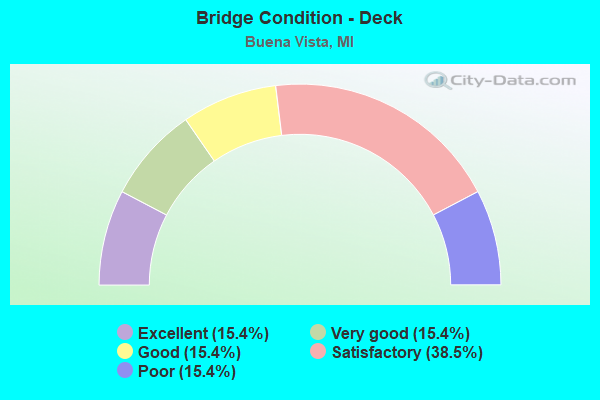
- Bridge Condition - Deck
- 15.4%Excellent
- 15.4%Very good
- 15.4%Good
- 38.5%Satisfactory
- 15.4%Poor
- Bridge Condition - Superstructure
- 23.1%Excellent
- 23.1%Very good
- 30.8%Good
- 15.4%Satisfactory
- 7.7%Fair
- Bridge Condition - Substructure
- 23.1%Excellent
- 7.7%Very good
- 15.4%Good
- 46.2%Satisfactory
- 7.7%Fair
Find on map >> Show street view
Structure Number: 9124, Location: @ I-75 (Lat: 43.429014, Lng: -83.889583), Route carried "on" structure: County highway , Year Built: 1971, Status: Open, Structure Length: 3.34m (10.96ft), Average Daily Traffic: 1,409 (year 1994), Truck Traffic: 3%, Average Future Daily Traffic: 1,040 (year 1977), Design Load: H 15, Features Intersected: I-675 RAMP, Facility Carried by Structure: JANES RD
Minimum Vertical Clearance: 30.48m (100.00ft), Kilometerpoint: 4.188, Lanes on structure: 2, Lanes under structure: 1, Owner: State Highway Agency, Approaching Roadway Width: 14.6m (47.9ft), Skew: 2 degrees, Material/Design: Steel, Design/Construction: Stringer/Multi-beam, Number Of Spans In Main Unit: 3, Length of Maximum Span: 13.3m (43.6ft), Curb-To-Curb Width: 8.7m (28.5ft), Out-to-Out Width: 9.9m (32.5ft)
Condition: Deck: Poor, Superstructure: Good, Substructure: Good, Operating Rating: 56.3 metric tons, Method Used To Determine Operating Rating: Load Factor (LF), Inventory Rating: 33.8 metric tons, Method Used To Determine Inventory Rating: Load Factor (LF), Structural Evaluation: Better than present minimum criteria, Deck Geometry: Somewhat better than minimum adequacy, Underclear: High priority of corrective action, Approach Roadway Alignment: Equal to present desirable criteria, Designated Inspection Frequency: Every 24 months, Other Special Inspection Frequency: Every 12 months, Inspection Date: October 2020, Other Special Inspection Date: October 2021, Deck Structure Type: Concrete Cast-file-Place, Wearing Surface/Protective System: Wearing Surface: Monolithic Concrete
Find on map >> Show street view
Structure Number: 9125, Location: @ S JCT I-75 (Lat: 43.433628, Lng: -83.890658), Route carried "on" structure: Interstate 675, Year Built: 1971, Status: Open, Structure Length: 8.23m (27.00ft), Average Daily Traffic: 10,300 (year 2007), Truck Traffic: 6%, Average Future Daily Traffic: 20,630 (year 2027), Design Load: HS 20, Features Intersected: I-75
Minimum Vertical Clearance: 30.48m (100.00ft), Kilometerpoint: 0.000, Lanes on structure: 2, Lanes under structure: 7, Base Highway Network: Yes (Inventory Route: 46, Subroute: 2), Owner: State Highway Agency, Approaching Roadway Width: 16.4m (53.8ft), Skew: 2 degrees, Material/Design: Steel, Design/Construction: Stringer/Multi-beam, Number Of Spans In Main Unit: 4, Length of Maximum Span: 30.0m (98.4ft), Curb-To-Curb Width: 11.9m (39.0ft), Out-to-Out Width: 13.1m (43.0ft)
Condition: Deck: Satisfactory, Superstructure: Good, Substructure: Satisfactory, Operating Rating: 79.0 metric tons, Method Used To Determine Operating Rating: Load Factor (LF), Inventory Rating: 47.4 metric tons, Method Used To Determine Inventory Rating: Load Factor (LF), Structural Evaluation: Equal to present minimum criteria, Deck Geometry: Equal to present minimum criteria, Underclear: Somewhat better than minimum adequacy, Approach Roadway Alignment: Equal to present desirable criteria, Designated Inspection Frequency: Every 24 months, Inspection Date: November 2020, Deck Structure Type: Concrete Cast-file-Place, Wearing Surface/Protective System: Wearing Surface: Latex Concrete
Find on map >> Show street view
Structure Number: 9126, Location: 0.1 MI W OF I-75 (Lat: 43.433639, Lng: -83.896386), Route carried "on" structure: County highway 2004, Year Built: 1971, Year Reconstructed: 2009, Status: Open, Structure Length: 8.63m (28.31ft), Average Daily Traffic: 10,489 (year 1994), Truck Traffic: 3%, Average Future Daily Traffic: 8,250 (year 1977), Design Load: H 15, Features Intersected: I-675, Facility Carried by Structure: OUTER DRIVE
Minimum Vertical Clearance: 30.48m (100.00ft), Kilometerpoint: 4.564, Lanes on structure: 2, Lanes under structure: 6, Base Highway Network: Yes (Inventory Route: 46, Subroute: 10), Owner: State Highway Agency, Approaching Roadway Width: 15.8m (51.8ft), Skew: 9 degrees, Material/Design: Steel, Design/Construction: Stringer/Multi-beam, Number Of Spans In Main Unit: 5, Length of Maximum Span: 24.3m (79.7ft), Curb or Sidewalk Widths: Left: 0.2m (0.7ft), Right: 0.2m (0.7ft), Curb-To-Curb Width: 9.9m (32.5ft), Out-to-Out Width: 11.1m (36.4ft)
Condition: Deck: Satisfactory, Superstructure: Fair, Substructure: Satisfactory, Operating Rating: 74.8 metric tons, Method Used To Determine Operating Rating: Load Factor (LF) rating reported by rating factor (RF) method using MS18 loading, Inventory Rating: 44.1 metric tons, Method Used To Determine Inventory Rating: Load Factor (LF) rating reported by rating factor (RF) method using MS18 loading, Structural Evaluation: Somewhat better than minimum adequacy, Deck Geometry: Meets minimum limits, Underclear: High priority of corrective action, Approach Roadway Alignment: Equal to present desirable criteria, Designated Inspection Frequency: Every 24 months, Inspection Date: October 2020, Deck Structure Type: Concrete Cast-file-Place, Wearing Surface/Protective System: Wearing Surface: Epoxy Overlay
Find on map >> Show street view
Structure Number: 9151, Location: @ N JCT I-75 (Lat: 43.431242, Lng: -83.890647), Route carried "on" structure: Ramp Interstate 675, Year Built: 1971, Status: Open, Structure Length: 11.55m (37.89ft), Average Daily Traffic: 1,290 (year 1982), Truck Traffic: 6%, Average Future Daily Traffic: 1,290 (year 2002), Design Load: HS 20, Features Intersected: I-675 & I-75
Minimum Vertical Clearance: 30.48m (100.00ft), Kilometerpoint: 0.838, Lanes on structure: 1, Lanes under structure: 7, Owner: State Highway Agency, Approaching Roadway Width: 11.5m (37.7ft), Skew: 9 degrees, Material/Design: Steel, Design/Construction: Stringer/Multi-beam, Number Of Spans In Main Unit: 6, Length of Maximum Span: 26.7m (87.6ft), Curb-To-Curb Width: 7.0m (23.0ft), Out-to-Out Width: 8.2m (26.9ft)
Condition: Deck: Satisfactory, Superstructure: Satisfactory, Substructure: Satisfactory, Operating Rating: 67.2 metric tons, Method Used To Determine Operating Rating: Load Factor (LF), Inventory Rating: 40.3 metric tons, Method Used To Determine Inventory Rating: Load Factor (LF), Structural Evaluation: Equal to present minimum criteria, Deck Geometry: Equal to present minimum criteria, Underclear: Meets minimum limits, Approach Roadway Alignment: Equal to present desirable criteria, Designated Inspection Frequency: Every 24 months, Inspection Date: November 2020, Deck Structure Type: Concrete Cast-file-Place, Wearing Surface/Protective System: Wearing Surface: Epoxy Overlay
Find on map >> Show street view
Structure Number: 9156, Location: 0.5 MI S OF M-81 (Lat: 43.443236, Lng: -83.890675), Route carried "on" structure: Interstate 75, Year Built: 1961, Year Reconstructed: 1999, Status: Open, Structure Length: 4.17m (13.68ft), Average Daily Traffic: 47,480 (year 2007), Truck Traffic: 12%, Average Future Daily Traffic: 57,597 (year 2018), Design Load: HS 25 or greater, Features Intersected: CSX RR
Minimum Vertical Clearance: 30.48m (100.00ft), Kilometerpoint: 27.621, Lanes on structure: 6, Base Highway Network: Yes (Inventory Route: 46, Subroute: 3), Owner: State Highway Agency, Approaching Roadway Width: 37.8m (124.0ft), Skew: 30 degrees, Material/Design: Prestressed concrete, Design/Construction: Box Beam or Girders - Single/Spread, Number Of Spans In Main Unit: 3, Length of Maximum Span: 14.0m (45.9ft), Curb-To-Curb Width: 38.1m (125.0ft), Out-to-Out Width: 40.2m (131.9ft)
Condition: Deck: Satisfactory, Superstructure: Very good, Substructure: Fair, Operating Rating: 59.9 metric tons, Method Used To Determine Operating Rating: Load Factor (LF) rating reported by rating factor (RF) method using MS18 loading, Inventory Rating: 36.0 metric tons, Method Used To Determine Inventory Rating: Load Factor (LF) rating reported by rating factor (RF) method using MS18 loading, Structural Evaluation: Somewhat better than minimum adequacy, Deck Geometry: Superior to present desirable criteria, Approach Roadway Alignment: Equal to present desirable criteria, Designated Inspection Frequency: Every 24 months, Inspection Date: September 2021, Deck Structure Type: Concrete Cast-file-Place, Wearing Surface/Protective System: Wearing Surface: Monolithic Concrete, Deck Protection: Epoxy Coated Reinforcing
Find on map >> Show street view
Structure Number: 9157, Location: 1.0 MI S OF M-13 (Lat: 43.467714, Lng: -83.893542), Route carried "on" structure: Interstate 75, Year Built: 1958, Year Reconstructed: 1977, Status: Open, Structure Length: 4.07m (13.35ft), Average Daily Traffic: 46,000 (year 2009), Truck Traffic: 10%, Average Future Daily Traffic: 51,849 (year 2032), Design Load: HS 20, Features Intersected: CSX RR
Minimum Vertical Clearance: 30.48m (100.00ft), Kilometerpoint: 30.387, Lanes on structure: 6, Base Highway Network: Yes (Inventory Route: 46, Subroute: 3), Owner: State Highway Agency, Approaching Roadway Width: 37.8m (124.0ft), Skew: 31 degrees, Material/Design: Steel, Design/Construction: Stringer/Multi-beam, Number Of Spans In Main Unit: 3, Length of Maximum Span: 13.4m (44.0ft), Curb-To-Curb Width: 37.8m (124.0ft), Out-to-Out Width: 39.4m (129.3ft)
Condition: Deck: Satisfactory, Superstructure: Good, Substructure: Satisfactory, Operating Rating: 63.2 metric tons, Method Used To Determine Operating Rating: Load Factor (LF) rating reported by rating factor (RF) method using MS18 loading, Inventory Rating: 37.6 metric tons, Method Used To Determine Inventory Rating: Load Factor (LF) rating reported by rating factor (RF) method using MS18 loading, Structural Evaluation: Equal to present minimum criteria, Deck Geometry: Superior to present desirable criteria, Approach Roadway Alignment: Equal to present desirable criteria, Designated Inspection Frequency: Every 24 months, Inspection Date: November 2020, Deck Structure Type: Concrete Cast-file-Place, Wearing Surface/Protective System: Wearing Surface: Epoxy Overlay
Find on map >> Show street view
Structure Number: 916, Location: 0.8 MI S OF M-46 (Lat: 43.401158, Lng: -83.890992), Route carried "on" structure: County highway 2004, Year Built: 2015, Status: Open, Structure Length: 5.98m (19.62ft), Average Daily Traffic: 4,080 (year 2015), Truck Traffic: 3%, Average Future Daily Traffic: 4,800 (year 2035), Design Load: Greater than HL93, Features Intersected: I-75, Facility Carried by Structure: HESS RD
Minimum Vertical Clearance: 30.48m (100.00ft), Kilometerpoint: 6.016, Lanes on structure: 2, Lanes under structure: 6, Owner: State Highway Agency, Approaching Roadway Width: 13.4m (44.0ft), Material/Design: Prestressed concrete, Design/Construction: Stringer/Multi-beam, Number Of Spans In Main Unit: 2, Length of Maximum Span: 29.4m (96.5ft), Curb-To-Curb Width: 13.4m (44.0ft), Out-to-Out Width: 14.4m (47.2ft)
Condition: Deck: Very good, Superstructure: Very good, Substructure: Satisfactory, Operating Rating: 70.3 metric tons, Method Used To Determine Operating Rating: Load and Resistance Factor Rating (LRFR) rating reported by rating factor(RF) method using HL-93 loadings, Inventory Rating: 41.5 metric tons, Method Used To Determine Inventory Rating: Load and Resistance Factor Rating (LRFR) rating reported by rating factor(RF) method using HL-93 loadings, Structural Evaluation: Equal to present minimum criteria, Deck Geometry: Better than present minimum criteria, Underclear: Equal to present minimum criteria, Approach Roadway Alignment: Equal to present minimum criteria, Designated Inspection Frequency: Every 24 months, Inspection Date: August 2021, Deck Structure Type: Concrete Cast-file-Place, Wearing Surface/Protective System: Wearing Surface: Monolithic Concrete, Deck Protection: Epoxy Coated Reinforcing
Find on map >> Show street view
Structure Number: 9161, Location: @ M-46 (Lat: 43.414678, Lng: -83.890800), Route carried "on" structure: State highway 46, Year Built: 2021, Status: Open, Structure Length: 6.17m (20.24ft), Average Daily Traffic: 16,800 (year 2020), Truck Traffic: 4%, Average Future Daily Traffic: 18,550 (year 2040), Design Load: Greater than HL93, Features Intersected: I-75
Minimum Vertical Clearance: 30.48m (100.00ft), Kilometerpoint: 6.418, Lanes on structure: 4, Lanes under structure: 10, Base Highway Network: Yes (Inventory Route: 373, Subroute: 53), Owner: State Highway Agency, Approaching Roadway Width: 17.1m (56.1ft), Material/Design: Prestressed concrete, Design/Construction: Stringer/Multi-beam, Number Of Spans In Main Unit: 2, Length of Maximum Span: 30.8m (101.0ft), Curb or Sidewalk Widths: Left: 0.0m, Right: 2.7m (8.9ft), Curb-To-Curb Width: 17.1m (56.1ft), Out-to-Out Width: 19.9m (65.3ft)
Condition: Deck: Very good, Superstructure: Excellent, Substructure: Excellent, Operating Rating: 63.2 metric tons, Method Used To Determine Operating Rating: Load and Resistance Factor Rating (LRFR) rating reported by rating factor(RF) method using HL-93 loadings, Inventory Rating: 37.9 metric tons, Method Used To Determine Inventory Rating: Load and Resistance Factor Rating (LRFR) rating reported by rating factor(RF) method using HL-93 loadings, Structural Evaluation: Superior to present desirable criteria, Deck Geometry: Somewhat better than minimum adequacy, Underclear: Meets minimum limits, Approach Roadway Alignment: Equal to present minimum criteria, Designated Inspection Frequency: Every 24 months, Inspection Date: September 2021, Deck Structure Type: Concrete Cast-file-Place, Wearing Surface/Protective System: Wearing Surface: Monolithic Concrete, Deck Protection: Epoxy Coated Reinforcing
Find on map >> Show street view
Structure Number: 9162, Location: 1.0 MI N OF M-46 & I-75 B (Lat: 43.429019, Lng: -83.890639), Route carried "on" structure: County highway , Year Built: 2012, Status: Open, Structure Length: 5.85m (19.19ft), Average Daily Traffic: 1,000 (year 2012), Truck Traffic: 5%, Average Future Daily Traffic: 1,200 (year 2032), Design Load: Greater than HL93, Features Intersected: I-75, Facility Carried by Structure: JANES RD
Minimum Vertical Clearance: 30.48m (100.00ft), Kilometerpoint: 4.102, Lanes on structure: 2, Lanes under structure: 8, Owner: State Highway Agency, Approaching Roadway Width: 12.2m (40.0ft), Material/Design: Steel continuous, Design/Construction: Stringer/Multi-beam, Number Of Spans In Main Unit: 2, Length of Maximum Span: 32.5m (106.6ft), Curb-To-Curb Width: 12.2m (40.0ft), Out-to-Out Width: 13.2m (43.3ft)
Condition: Deck: Good, Superstructure: Very good, Substructure: Very good, Operating Rating: 47.3 metric tons, Method Used To Determine Operating Rating: Load and Resistance Factor Rating (LRFR) rating reported by rating factor(RF) method using HL-93 loadings, Inventory Rating: 36.6 metric tons, Method Used To Determine Inventory Rating: Load and Resistance Factor Rating (LRFR) rating reported by rating factor(RF) method using HL-93 loadings, Structural Evaluation: Equal to present desirable criteria, Deck Geometry: Equal to present desirable criteria, Underclear: Somewhat better than minimum adequacy, Approach Roadway Alignment: Somewhat better than minimum adequacy, Designated Inspection Frequency: Every 24 months, Inspection Date: November 2020, Deck Structure Type: Concrete Cast-file-Place, Wearing Surface/Protective System: Wearing Surface: Epoxy Overlay, Deck Protection: Epoxy Coated Reinforcing
Find on map >> Show street view
Structure Number: 9163, Location: 1.0 MI S OF M-81 (Lat: 43.436236, Lng: -83.890656), Route carried "on" structure: County highway , Year Built: 1961, Year Reconstructed: 1971, Status: Posted for load, Structure Length: 7.15m (23.46ft), Average Daily Traffic: 360 (year 2012), Truck Traffic: 5%, Average Future Daily Traffic: 450 (year 2032), Design Load: H 15, Features Intersected: I-75, Facility Carried by Structure: WADSWORTH RD
Minimum Vertical Clearance: 30.48m (100.00ft), Kilometerpoint: 2.018, Lanes on structure: 2, Lanes under structure: 7, Owner: State Highway Agency, Approaching Roadway Width: 12.8m (42.0ft), Material/Design: Steel, Design/Construction: Stringer/Multi-beam, Number Of Spans In Main Unit: 5, Length of Maximum Span: 19.2m (63.0ft), Curb-To-Curb Width: 9.1m (29.9ft), Out-to-Out Width: 10.2m (33.5ft)
Condition: Deck: Poor, Superstructure: Satisfactory, Substructure: Satisfactory, Operating Rating: 37.3 metric tons, Method Used To Determine Operating Rating: Load Factor (LF) rating reported by rating factor (RF) method using MS18 loading, Inventory Rating: 22.4 metric tons, Method Used To Determine Inventory Rating: Load Factor (LF) rating reported by rating factor (RF) method using MS18 loading, Structural Evaluation: Equal to present minimum criteria, Deck Geometry: Equal to present minimum criteria, Underclear: High priority of corrective action, Approach Roadway Alignment: Equal to present desirable criteria, Bridge Posting: Required (Relationship of Operating Rating to Maximum Legal Load: 20.0 - 29.9% below), Designated Inspection Frequency: Every 24 months, Other Special Inspection Frequency: Every 12 months, Inspection Date: November 2020, Other Special Inspection Date: November 2021, Deck Structure Type: Concrete Cast-file-Place, Wearing Surface/Protective System: Wearing Surface: Bituminous, Membrane: Preformed Fabric
Find on map >> Show street view
Structure Number: 9164, Location: @ M-81 (Lat: 43.450625, Lng: -83.890672), Route carried "on" structure: State highway 81, Year Built: 2006, Status: Open, Structure Length: 5.93m (19.46ft), Average Daily Traffic: 16,400 (year 2005), Truck Traffic: 8%, Average Future Daily Traffic: 29,620 (year 2025), Design Load: HS 25 or greater, Features Intersected: I-75
Minimum Vertical Clearance: 30.48m (100.00ft), Kilometerpoint: 16.088, Lanes on structure: 2, Lanes under structure: 6, Base Highway Network: Yes (Inventory Route: 47, Subroute: 10), Owner: State Highway Agency, Approaching Roadway Width: 15.2m (49.9ft), Material/Design: Steel continuous, Design/Construction: Stringer/Multi-beam, Number Of Spans In Main Unit: 2, Length of Maximum Span: 29.2m (95.8ft), Curb-To-Curb Width: 14.6m (47.9ft), Out-to-Out Width: 15.6m (51.2ft)
Condition: Deck: Good, Superstructure: Good, Substructure: Good, Operating Rating: 82.3 metric tons, Method Used To Determine Operating Rating: Load Factor (LF) rating reported by rating factor (RF) method using MS18 loading, Inventory Rating: 49.2 metric tons, Method Used To Determine Inventory Rating: Load Factor (LF) rating reported by rating factor (RF) method using MS18 loading, Structural Evaluation: Better than present minimum criteria, Deck Geometry: Superior to present desirable criteria, Underclear: Somewhat better than minimum adequacy, Approach Roadway Alignment: Equal to present desirable criteria, Designated Inspection Frequency: Every 24 months, Inspection Date: Febuary 2021, Deck Structure Type: Concrete Cast-file-Place, Wearing Surface/Protective System: Wearing Surface: Monolithic Concrete, Deck Protection: Epoxy Coated Reinforcing
Find on map >> Show street view
Structure Number: 14325, Location: 0.3 MI S OF M-46 (Lat: 43.409408, Lng: -83.890872), Route carried "on" structure: Interstate 75, Year Built: 2021, Status: Open, Structure Length: 3.69m (12.11ft), Average Daily Traffic: 32,900 (year 2020), Truck Traffic: 7%, Average Future Daily Traffic: 36,375 (year 2040), Design Load: Greater than HL93, Features Intersected: CSX RR
Minimum Vertical Clearance: 30.48m (100.00ft), Kilometerpoint: 23.861, Lanes on structure: 4, Base Highway Network: Yes (Inventory Route: 46, Subroute: 3), Owner: State Highway Agency, Approaching Roadway Width: 21.5m (70.5ft), Skew: 1 degrees, Material/Design: Prestressed concrete, Design/Construction: Stringer/Multi-beam, Number Of Spans In Main Unit: 1, Length of Maximum Span: 36.0m (118.1ft), Curb-To-Curb Width: 21.4m (70.2ft), Out-to-Out Width: 22.3m (73.2ft)
Condition: Deck: Excellent, Superstructure: Excellent, Substructure: Excellent, Operating Rating: 71.6 metric tons, Method Used To Determine Operating Rating: Load and Resistance Factor Rating (LRFR) rating reported by rating factor(RF) method using HL-93 loadings, Inventory Rating: 37.9 metric tons, Method Used To Determine Inventory Rating: Load and Resistance Factor Rating (LRFR) rating reported by rating factor(RF) method using HL-93 loadings, Structural Evaluation: Superior to present desirable criteria, Deck Geometry: Better than present minimum criteria, Approach Roadway Alignment: Equal to present desirable criteria, Designated Inspection Frequency: Every 20 months, Inspection Date: January 2022, Deck Structure Type: Concrete Cast-file-Place, Wearing Surface/Protective System: Wearing Surface: Monolithic Concrete, Deck Protection: Epoxy Coated Reinforcing
Find on map >> Show street view
Structure Number: 14326, Location: 0.3 MI S OF M-46 (Lat: 43.409447, Lng: -83.891144), Route carried "on" structure: Interstate 75, Year Built: 2021, Status: Open, Structure Length: 3.69m (12.11ft), Average Daily Traffic: 32,900 (year 2020), Truck Traffic: 7%, Average Future Daily Traffic: 36,375 (year 2040), Design Load: Greater than HL93, Features Intersected: CSX RR
Minimum Vertical Clearance: 30.48m (100.00ft), Kilometerpoint: 23.860, Lanes on structure: 4, Base Highway Network: Yes (Inventory Route: 46, Subroute: 2), Owner: State Highway Agency, Approaching Roadway Width: 21.5m (70.5ft), Skew: 1 degrees, Material/Design: Prestressed concrete, Design/Construction: Stringer/Multi-beam, Number Of Spans In Main Unit: 1, Length of Maximum Span: 36.0m (118.1ft), Curb-To-Curb Width: 21.4m (70.2ft), Out-to-Out Width: 22.3m (73.2ft)
Condition: Deck: Excellent, Superstructure: Excellent, Substructure: Excellent, Operating Rating: 71.6 metric tons, Method Used To Determine Operating Rating: Load and Resistance Factor Rating (LRFR) rating reported by rating factor(RF) method using HL-93 loadings, Inventory Rating: 37.9 metric tons, Method Used To Determine Inventory Rating: Load and Resistance Factor Rating (LRFR) rating reported by rating factor(RF) method using HL-93 loadings, Structural Evaluation: Superior to present desirable criteria, Deck Geometry: Better than present minimum criteria, Approach Roadway Alignment: Equal to present desirable criteria, Designated Inspection Frequency: Every 20 months, Inspection Date: January 2022, Deck Structure Type: Concrete Cast-file-Place, Wearing Surface/Protective System: Wearing Surface: Monolithic Concrete, Deck Protection: Epoxy Coated Reinforcing
Find on map >> Show street view
Structure Number: 9124, Location: @ I-75 (Lat: 43.429014, Lng: -83.889583), Route carried "under" structure: Ramp Interstate 675, Year Built: 1971, Structure Length: 0. m, Average Daily Traffic: 8,250 (year 1988), Features Intersected: I-675 RAMP, Facility Carried by Structure: JANES RD
Minimum Vertical Clearance: 30+ m (98+ ft), Kilometerpoint: 0.364, Lanes on structure: 2, Lanes under structure: 1, Material/Design: Steel, Design/Construction: Stringer/Multi-beam, Length of Maximum Span: 13.3m (43.6ft)
Find on map >> Show street view
Structure Number: 9125, Location: @ S JCT I-75 (Lat: 43.433628, Lng: -83.890658), Route carried "under" structure: Interstate 75, Year Built: 1971, Structure Length: 0. m, Average Daily Traffic: 47,480 (year 2007), Truck Traffic: 12%, Features Intersected: I-75
Minimum Vertical Clearance: 4.95m (16.24ft), Kilometerpoint: 26.553, Lanes on structure: 2, Lanes under structure: 7, Material/Design: Steel, Design/Construction: Stringer/Multi-beam, Length of Maximum Span: 30.0m (98.4ft)
Find on map >> Show street view
Structure Number: 9126, Location: 0.1 MI W OF I-75 (Lat: 43.433639, Lng: -83.896386), Route carried "under" structure: Interstate 675, Year Built: 1971, Structure Length: 0. m, Average Daily Traffic: 18,738 (year 2017), Truck Traffic: 9%, Features Intersected: I-675, Facility Carried by Structure: OUTER DRIVE
Minimum Vertical Clearance: 4.55m (14.93ft), Kilometerpoint: 0.478, Lanes on structure: 2, Lanes under structure: 6, Material/Design: Steel, Design/Construction: Stringer/Multi-beam, Length of Maximum Span: 24.3m (79.7ft)
Find on map >> Show street view
Structure Number: 9151, Location: @ N JCT I-75 (Lat: 43.431242, Lng: -83.890647), Route carried "under" structure: Interstate 675, Year Built: 1971, Structure Length: 0. m, Average Daily Traffic: 69,334 (year 2007), Truck Traffic: 12%, Features Intersected: I-675 & I-75
Minimum Vertical Clearance: 5.36m (17.59ft), Kilometerpoint: 26.288, Lanes on structure: 1, Lanes under structure: 7, Material/Design: Steel, Design/Construction: Stringer/Multi-beam, Length of Maximum Span: 26.7m (87.6ft)
Find on map >> Show street view
Structure Number: 916, Location: 0.8 MI S OF M-46 (Lat: 43.401158, Lng: -83.890992), Route carried "under" structure: Interstate 75, Year Built: 2015, Structure Length: 0. m, Average Daily Traffic: 59,200 (year 2013), Truck Traffic: 7%, Features Intersected: I-75, Facility Carried by Structure: HESS RD
Minimum Vertical Clearance: 5.89m (19.32ft), Kilometerpoint: 22.947, Lanes on structure: 2, Lanes under structure: 6, Material/Design: Prestressed concrete, Design/Construction: Stringer/Multi-beam, Length of Maximum Span: 29.4m (96.5ft)
Find on map >> Show street view
Structure Number: 9161, Location: @ M-46 (Lat: 43.414678, Lng: -83.890800), Route carried "under" structure: Interstate 75, Year Built: 2021, Structure Length: 0. m, Average Daily Traffic: 65,800 (year 2020), Truck Traffic: 7%, Features Intersected: I-75, Facility Carried by Structure: M-46
Minimum Vertical Clearance: 4.95m (16.24ft), Kilometerpoint: 24.448, Lanes on structure: 4, Lanes under structure: 10, Material/Design: Prestressed concrete, Design/Construction: Stringer/Multi-beam, Length of Maximum Span: 30.8m (101.0ft)
Find on map >> Show street view
Structure Number: 9162, Location: 1.0 MI N OF M-46 & I-75 B (Lat: 43.429019, Lng: -83.890639), Route carried "under" structure: Interstate 75, Year Built: 2012, Structure Length: 0. m, Average Daily Traffic: 69,334 (year 2007), Truck Traffic: 9%, Features Intersected: I-75, Facility Carried by Structure: JANES RD
Minimum Vertical Clearance: 4.88m (16.01ft), Kilometerpoint: 26.040, Lanes on structure: 2, Lanes under structure: 8, Material/Design: Steel continuous, Design/Construction: Stringer/Multi-beam, Length of Maximum Span: 32.5m (106.6ft)
Find on map >> Show street view
Structure Number: 9163, Location: 1.0 MI S OF M-81 (Lat: 43.436236, Lng: -83.890656), Route carried "under" structure: Interstate 75, Year Built: 1961, Structure Length: 0. m, Average Daily Traffic: 47,480 (year 2007), Truck Traffic: 12%, Features Intersected: I-75, Facility Carried by Structure: WADSWORTH RD
Minimum Vertical Clearance: 5.28m (17.32ft), Kilometerpoint: 26.842, Lanes on structure: 2, Lanes under structure: 7, Material/Design: Steel, Design/Construction: Stringer/Multi-beam, Length of Maximum Span: 19.2m (63.0ft)
Find on map >> Show street view
Structure Number: 9164, Location: @ M-81 (Lat: 43.450625, Lng: -83.890672), Route carried "under" structure: Interstate 75, Year Built: 2006, Structure Length: 0. m, Average Daily Traffic: 47,480 (year 2007), Truck Traffic: 10%, Features Intersected: I-75, Facility Carried by Structure: M-81,WASHINGTON ST
Minimum Vertical Clearance: 5.08m (16.67ft), Kilometerpoint: 28.440, Lanes on structure: 2, Lanes under structure: 6, Material/Design: Steel continuous, Design/Construction: Stringer/Multi-beam, Length of Maximum Span: 29.2m (95.8ft)