Bridge Statistics for Bulger, Pennsylvania (PA)
Condition, Traffic, Stress, Structural Evaluation, Project Costs
- National Bridge Inventory (NBI) Statistics
- 21Number of bridges
- 157ft / 47.8mTotal length
- $775,000Total costs
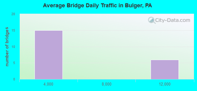
- 77,050Total average daily traffic
- 8,592Total average daily truck traffic
- National Bridge Inventory (NBI) Registered Bridges for Bulger
- No street view available for this location
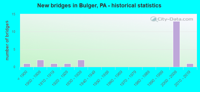
- New bridges - historical statistics
- 1Before 1900
- 21900-1909
- 11910-1919
- 11920-1929
- 21930-1939
- 132000-2009
- 12010-2019
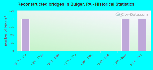
- Reconstructed bridges - Historical Statistics
- 11940-1949
- 01950-1959
- 01960-1969
- 01970-1979
- 01980-1989
- 01990-1999
- 12000-2009
- 12010-2019
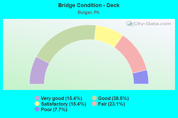
- Bridge Condition - Deck
- 15.4%Very good
- 38.5%Good
- 15.4%Satisfactory
- 23.1%Fair
- 7.7%Poor
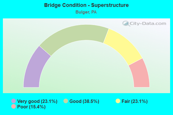
- Bridge Condition - Superstructure
- 23.1%Very good
- 38.5%Good
- 23.1%Fair
- 15.4%Poor
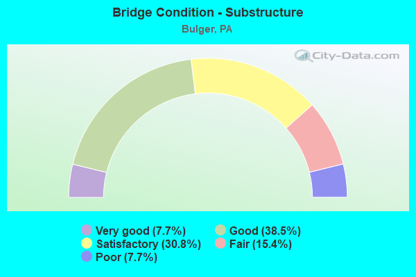
- Bridge Condition - Substructure
- 7.7%Very good
- 38.5%Good
- 30.8%Satisfactory
- 15.4%Fair
- 7.7%Poor
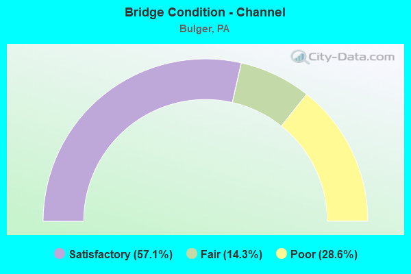
- Bridge Condition - Channel
- 57.1%Satisfactory
- 14.3%Fair
- 28.6%Poor
Find on map >> Show street view
Structure Number: 35123, Location: ROBINSON TOWNSHIP (Lat: 40.403214, Lng: -80.306992), Route carried "on" structure: State highway , Year Built: 1929, Status: Open, Structure Length: 0.70m (2.30ft), Average Daily Traffic: 312 (year 2022), Truck Traffic: 7%, Average Future Daily Traffic: 350 (year 2032), Design Load: HS 20, Features Intersected: RACCOON CREEK, Facility Carried by Structure: SR 4009
Minimum Vertical Clearance: 30+ m (98+ ft), Kilometerpoint: 4.387, Lanes on structure: 2, Owner: State Highway Agency, Approaching Roadway Width: 4.9m (16.1ft), Material/Design: Concrete continuous, Design/Construction: Stringer/Multi-beam, Number Of Spans In Main Unit: 1, Length of Maximum Span: 6.4m (21.0ft), Curb or Sidewalk Widths: Left: 0.2m (0.7ft), Right: 0.2m (0.7ft), Curb-To-Curb Width: 6.9m (22.6ft), Out-to-Out Width: 7.8m (25.6ft)
Condition: Deck: Satisfactory, Superstructure: Fair, Substructure: Satisfactory, Channel: Satisfactory, Operating Rating: 92.5 metric tons, Method Used To Determine Operating Rating: Load Factor (LF), Inventory Rating: 55.3 metric tons, Method Used To Determine Inventory Rating: Load Factor (LF), Structural Evaluation: Somewhat better than minimum adequacy, Deck Geometry: Meets minimum limits, Waterway Adequacy: Superior to present desirable criteria, Approach Roadway Alignment: Equal to present desirable criteria, Length Of Structure Improvement: 1.30m (4.27ft), Designated Inspection Frequency: Every 24 months, Inspection Date: June 2020, Bridge Improvement Cost: $9,000, Roadway Improvement Cost: $27,000, Total Project Cost: $124,000, Deck Structure Type: Concrete Cast-file-Place, Wearing Surface/Protective System: Wearing Surface: Bituminous
Find on map >> Show street view
Structure Number: 35145, Location: MOUNT PLEASANT TOWNSHIP (Lat: 40.341169, Lng: -80.330558), Route carried "on" structure: State highway , Year Built: 1938, Year Reconstructed: 1948, Status: Open, Structure Length: 0.88m (2.89ft), Average Daily Traffic: 1,053 (year 2020), Truck Traffic: 3%, Average Future Daily Traffic: 684 (year 2032), Design Load: H 20, Features Intersected: CHERRY RUN, Facility Carried by Structure: SR 4015
Minimum Vertical Clearance: 30+ m (98+ ft), Kilometerpoint: 6.035, Lanes on structure: 2, Owner: State Highway Agency, Approaching Roadway Width: 6.7m (22.0ft), Material/Design: Steel, Design/Construction: Stringer/Multi-beam, Number Of Spans In Main Unit: 1, Length of Maximum Span: 8.5m (27.9ft), Curb or Sidewalk Widths: Left: 0.2m (0.7ft), Right: 0.2m (0.7ft), Curb-To-Curb Width: 6.7m (22.0ft), Out-to-Out Width: 7.4m (24.3ft)
Condition: Deck: Fair, Superstructure: Fair, Substructure: Satisfactory, Channel: Fair, Operating Rating: 54.4 metric tons, Method Used To Determine Operating Rating: Load Factor (LF), Inventory Rating: 32.7 metric tons, Method Used To Determine Inventory Rating: Load Factor (LF), Structural Evaluation: Somewhat better than minimum adequacy, Deck Geometry: High priority of corrective action, Waterway Adequacy: Superior to present desirable criteria, Approach Roadway Alignment: Better than present minimum criteria, Length Of Structure Improvement: 1.60m (5.25ft), Designated Inspection Frequency: Every 24 months, Inspection Date: June 2020, Bridge Improvement Cost: $5,000, Roadway Improvement Cost: $13,000, Total Project Cost: $62,000, Deck Structure Type: Concrete Cast-file-Place, Wearing Surface/Protective System: Wearing Surface: Bituminous
Find on map >> Show street view
Structure Number: 35146, Location: SMITH TOWNSHIP (Lat: 40.347683, Lng: -80.333978), Route carried "on" structure: State highway , Year Built: 1912, Status: Open, Structure Length: 0.76m (2.49ft), Average Daily Traffic: 851 (year 2022), Truck Traffic: 9%, Average Future Daily Traffic: 1,013 (year 2032), Features Intersected: BULGER RUN, Facility Carried by Structure: SR 4015
Minimum Vertical Clearance: 30+ m (98+ ft), Kilometerpoint: 6.832, Lanes on structure: 2, Owner: State Highway Agency, Approaching Roadway Width: 5.5m (18.0ft), Skew: 2 degrees, Material/Design: Steel, Design/Construction: Stringer/Multi-beam, Number Of Spans In Main Unit: 1, Length of Maximum Span: 6.4m (21.0ft), Curb-To-Curb Width: 5.6m (18.4ft), Out-to-Out Width: 6.0m (19.7ft)
Condition: Deck: Poor, Superstructure: Poor, Substructure: Fair, Channel: Poor, Operating Rating: 57.2 metric tons, Method Used To Determine Operating Rating: Field evaluation and documented engineering judgment, Inventory Rating: 34.5 metric tons, Method Used To Determine Inventory Rating: Field evaluation and documented engineering judgment, Structural Evaluation: Meets minimum limits, Deck Geometry: High priority of replacement, Waterway Adequacy: Superior to present desirable criteria, Approach Roadway Alignment: Equal to present desirable criteria, Length Of Structure Improvement: 0.80m (2.62ft), Designated Inspection Frequency: Every 24 months, Inspection Date: June 2020, Bridge Improvement Cost: $4,000, Roadway Improvement Cost: $12,000, Total Project Cost: $55,000, Wearing Surface/Protective System: Wearing Surface: Bituminous
Find on map >> Show street view
Structure Number: 35306, Location: 200' WEST OF SR 4015 (Lat: 40.340853, Lng: -80.331047), Route carried "on" structure: City street T799, Year Built: 1887, Status: Posted for load, Structure Length: 0.88m (2.89ft), Average Daily Traffic: 40 (year 1993), Average Future Daily Traffic: 40 (year 2010), Design Load: H 15, Features Intersected: RACCOON CREEK
Minimum Vertical Clearance: 3.28m (10.76ft), Kilometerpoint: 0.000, Lanes on structure: 1, Base Highway Network: Yes, Owner: County Highway Agency, Approaching Roadway Width: 3.0m (9.8ft), Material/Design: Wood or Timber, Design/Construction: Truss - Thru, Number Of Spans In Main Unit: 2, Length of Maximum Span: 4.0m (13.1ft), Curb or Sidewalk Widths: Left: 0.1m (0.3ft), Right: 0.1m (0.3ft), Curb-To-Curb Width: 3.4m (11.2ft), Out-to-Out Width: 3.7m (12.1ft)
Condition: Deck: Fair, Superstructure: Poor, Substructure: Poor, Channel: Satisfactory, Operating Rating: 12.7 metric tons, Method Used To Determine Operating Rating: Allowable Stress (AS), Inventory Rating: 9.1 metric tons, Method Used To Determine Inventory Rating: Allowable Stress (AS), Structural Evaluation: High priority of corrective action, Deck Geometry: High priority of corrective action, Waterway Adequacy: Better than present minimum criteria, Approach Roadway Alignment: Equal to present minimum criteria, Bridge Posting: Required (Relationship of Operating Rating to Maximum Legal Load: > 39.9% below), Length Of Structure Improvement: 1.60m (5.25ft), Designated Inspection Frequency: Every 24 months, Critical Feature Inspection Frequency: Every 12 months, Other Special Inspection Frequency: Every 12 months, Inspection Date: August 2021, Critical Feature Inspection Date: August 2021, Other Special Inspection Date: August 2021, Bridge Improvement Cost: $1,000, Roadway Improvement Cost: $4,000, Total Project Cost: $18,000, Deck Structure Type: Wood or Timber, Wearing Surface/Protective System: Wearing Surface: Wood or Timber
Find on map >> Show street view
Structure Number: 35328, Location: SOUTH OF SR4026 OFF RT22 (Lat: 40.418044, Lng: -80.340717), Route carried "on" structure: City street T611, Year Built: 1932, Status: Open, Structure Length: 1.46m (4.79ft), Average Daily Traffic: 100 (year 2004), Truck Traffic: 2%, Average Future Daily Traffic: 70 (year 2010), Features Intersected: SAINT PATRICK RUN, Facility Carried by Structure: TOWNSHIP ROAD 611
Minimum Vertical Clearance: 30+ m (98+ ft), Kilometerpoint: 0.000, Lanes on structure: 2, Owner: Town or Township Highway Agency, Approaching Roadway Width: 12.2m (40.0ft), Skew: 4 degrees, Material/Design: Steel, Design/Construction: Stringer/Multi-beam, Number Of Spans In Main Unit: 1, Length of Maximum Span: 14.0m (45.9ft), Curb or Sidewalk Widths: Left: 0.2m (0.7ft), Right: 0.2m (0.7ft), Curb-To-Curb Width: 13.4m (44.0ft), Out-to-Out Width: 13.9m (45.6ft)
Condition: Deck: Fair, Superstructure: Fair, Substructure: Fair, Channel: Poor, Operating Rating: 49.0 metric tons, Method Used To Determine Operating Rating: Field evaluation and documented engineering judgment, Inventory Rating: 32.7 metric tons, Method Used To Determine Inventory Rating: Field evaluation and documented engineering judgment, Structural Evaluation: Somewhat better than minimum adequacy, Deck Geometry: Superior to present desirable criteria, Waterway Adequacy: Better than present minimum criteria, Approach Roadway Alignment: Equal to present desirable criteria, Length Of Structure Improvement: 2.10m (6.89ft), Designated Inspection Frequency: Every 24 months, Inspection Date: November 2020, Bridge Improvement Cost: $19,000, Roadway Improvement Cost: $56,000, Total Project Cost: $257,000, Deck Structure Type: Concrete Cast-file-Place, Wearing Surface/Protective System: Wearing Surface: Bituminous
Find on map >> Show street view
Structure Number: 35329, Location: 200' EAST OF FOLEY RD (Lat: 40.401425, Lng: -80.321558), Route carried "on" structure: City street T839, Year Built: 1904, Year Reconstructed: 2014, Status: Open, Structure Length: 1.86m (6.10ft), Average Daily Traffic: 40 (year 2014), Average Future Daily Traffic: 40 (year 2034), Design Load: HL 93, Features Intersected: RACCOON CREEK trib, Facility Carried by Structure: VALLEYVIEW ROAD
Minimum Vertical Clearance: 30+ m (98+ ft), Kilometerpoint: 0.000, Lanes on structure: 1, Base Highway Network: Yes, Owner: County Highway Agency, Approaching Roadway Width: 3.0m (9.8ft), Skew: 4 degrees, Material/Design: Prestressed concrete, Design/Construction: Box Beam or Girders - Multiple, Number Of Spans In Main Unit: 1, Length of Maximum Span: 17.1m (56.1ft), Curb-To-Curb Width: 4.5m (14.8ft), Out-to-Out Width: 5.1m (16.7ft)
Condition: Deck: Very good, Superstructure: Very good, Substructure: Good, Channel: Satisfactory, Operating Rating: 46.7 metric tons, Method Used To Determine Operating Rating: Assigned ratings based on Load and Resistance Factor Design (LRFD) reported by rating factor (RF) using HL93 loadings, Inventory Rating: 36.0 metric tons, Method Used To Determine Inventory Rating: Assigned ratings based on Load and Resistance Factor Design (LRFD) reported by rating factor (RF) using HL93 loadings, Structural Evaluation: Better than present minimum criteria, Deck Geometry: Equal to present minimum criteria, Waterway Adequacy: Better than present minimum criteria, Approach Roadway Alignment: Equal to present minimum criteria, Length Of Structure Improvement: 2.40m (7.87ft), Designated Inspection Frequency: Every 24 months, Inspection Date: June 2021, Bridge Improvement Cost: $8,000, Roadway Improvement Cost: $25,000, Total Project Cost: $113,000, Deck Structure Type: Concrete Cast-file-Place, Wearing Surface/Protective System: Wearing Surface: Monolithic Concrete, Deck Protection: Epoxy Coated Reinforcing
Find on map >> Show street view
Structure Number: 3533, Location: 700' WEST OF TR 839 (Lat: 40.403750, Lng: -80.339325), Route carried "on" structure: City street T506, Year Built: 1904, Year Reconstructed: 2019, Status: Open, Structure Length: 1.49m (4.89ft), Average Daily Traffic: 20 (year 2019), Average Future Daily Traffic: 20 (year 2039), Design Load: HS 20, Features Intersected: RACCOON CREEK TRIB, Facility Carried by Structure: Maple Grove Road
Minimum Vertical Clearance: 30+ m (98+ ft), Kilometerpoint: 0.000, Lanes on structure: 1, Owner: County Highway Agency, Approaching Roadway Width: 2.7m (8.9ft), Material/Design: Steel, Design/Construction: Stringer/Multi-beam, Number Of Spans In Main Unit: 1, Length of Maximum Span: 14.3m (46.9ft), Curb-To-Curb Width: 4.5m (14.8ft), Out-to-Out Width: 4.9m (16.1ft)
Condition: Deck: Very good, Superstructure: Very good, Substructure: Good, Channel: Satisfactory, Operating Rating: 81.7 metric tons, Method Used To Determine Operating Rating: Assigned ratings based on Load and Resistance Factor Design (LRFD) reported in metric tons, Inventory Rating: 62.6 metric tons, Method Used To Determine Inventory Rating: Assigned ratings based on Load and Resistance Factor Design (LRFD) reported in metric tons, Structural Evaluation: Better than present minimum criteria, Deck Geometry: Equal to present minimum criteria, Waterway Adequacy: Better than present minimum criteria, Approach Roadway Alignment: Meets minimum limits, Length Of Structure Improvement: 2.20m (7.22ft), Designated Inspection Frequency: Every 24 months, Inspection Date: August 2021, Bridge Improvement Cost: $11,000, Roadway Improvement Cost: $32,000, Total Project Cost: $146,000, Deck Structure Type: Corrugated Steel, Wearing Surface/Protective System: Wearing Surface: Monolithic Concrete
Find on map >> Show street view
Structure Number: 44014, Location: Over SR 0022 (Lat: 40.424492, Lng: -80.312839), Route carried "on" structure: State highway , Year Built: 2006, Status: Open, Structure Length: 9.24m (30.31ft), Average Daily Traffic: 312 (year 2022), Truck Traffic: 7%, Average Future Daily Traffic: 350 (year 2032), Design Load: HL 93, Features Intersected: SR 0022, Facility Carried by Structure: SR 4009
Minimum Vertical Clearance: 30+ m (98+ ft), Kilometerpoint: 6.706, Lanes on structure: 2, Lanes under structure: 4, Owner: State Highway Agency, Approaching Roadway Width: 10.4m (34.1ft), Skew: 2 degrees, Material/Design: Prestressed concrete continuous, Design/Construction: Box Beam or Girders - Multiple, Number Of Spans In Main Unit: 3, Length of Maximum Span: 38.1m (125.0ft), Curb-To-Curb Width: 10.4m (34.1ft), Out-to-Out Width: 11.4m (37.4ft)
Condition: Deck: Satisfactory, Superstructure: Good, Substructure: Good, Operating Rating: 74.4 metric tons, Method Used To Determine Operating Rating: Load and Resistance Factor (LRFR), Inventory Rating: 39.9 metric tons, Method Used To Determine Inventory Rating: Load and Resistance Factor (LRFR), Structural Evaluation: Better than present minimum criteria, Deck Geometry: Better than present minimum criteria, Underclear: Meets minimum limits, Approach Roadway Alignment: Equal to present desirable criteria, Designated Inspection Frequency: Every 48 months, Inspection Date: October 2021, Deck Structure Type: Concrete Cast-file-Place, Wearing Surface/Protective System: Wearing Surface: Monolithic Concrete, Deck Protection: Epoxy Coated Reinforcing
Find on map >> Show street view
Structure Number: 4535, Location: ROBINSON TWP (Lat: 40.424267, Lng: -80.317828), Route carried "on" structure: Ramp Interstate 576, Year Built: 2006, Status: Open, Structure Length: 7.19m (23.59ft), Average Daily Traffic: 2,025 (year 2008), Truck Traffic: 8%, Average Future Daily Traffic: 7,300 (year 2030), Design Load: HS 20, Features Intersected: RAMP RE OVER SR 22
Minimum Vertical Clearance: 30+ m (98+ ft), Kilometerpoint: 0.000, Lanes on structure: 2, Lanes under structure: 4, Base Highway Network: Yes, Toll: Toll bridge, Owner: State Toll Authority, Approaching Roadway Width: 14.0m (45.9ft), Material/Design: Steel continuous, Design/Construction: Stringer/Multi-beam, Number Of Spans In Main Unit: 2, Length of Maximum Span: 35.4m (116.1ft), Curb-To-Curb Width: 14.0m (45.9ft), Out-to-Out Width: 15.0m (49.2ft)
Condition: Deck: Good, Superstructure: Good, Substructure: Good, Operating Rating: 72.6 metric tons, Method Used To Determine Operating Rating: Load and Resistance Factor (LRFR), Inventory Rating: 55.3 metric tons, Method Used To Determine Inventory Rating: Load and Resistance Factor (LRFR), Structural Evaluation: Better than present minimum criteria, Deck Geometry: Superior to present desirable criteria, Underclear: Better than present minimum criteria, Approach Roadway Alignment: Equal to present desirable criteria, Designated Inspection Frequency: Every 24 months, Inspection Date: May 2021, Deck Structure Type: Concrete Cast-file-Place, Wearing Surface/Protective System: Wearing Surface: Monolithic Concrete, Deck Protection: Epoxy Coated Reinforcing
Find on map >> Show street view
Structure Number: 45351, Location: ROBINSON TWP (Lat: 40.424086, Lng: -80.319272), Route carried "on" structure: Ramp Interstate 576, Year Built: 2004, Status: Open, Structure Length: 7.19m (23.59ft), Average Daily Traffic: 2,025 (year 2008), Truck Traffic: 8%, Average Future Daily Traffic: 7,300 (year 2030), Design Load: HS 20, Features Intersected: RAMP S OVER SR 22
Minimum Vertical Clearance: 30+ m (98+ ft), Kilometerpoint: 0.000, Lanes on structure: 2, Lanes under structure: 4, Base Highway Network: Yes, Toll: Toll bridge, Owner: State Toll Authority, Approaching Roadway Width: 14.0m (45.9ft), Material/Design: Steel continuous, Design/Construction: Stringer/Multi-beam, Number Of Spans In Main Unit: 2, Length of Maximum Span: 35.4m (116.1ft), Curb-To-Curb Width: 14.0m (45.9ft), Out-to-Out Width: 15.0m (49.2ft)
Condition: Deck: Good, Superstructure: Very good, Substructure: Good, Operating Rating: 91.6 metric tons, Method Used To Determine Operating Rating: Load Factor (LF), Inventory Rating: 55.3 metric tons, Method Used To Determine Inventory Rating: Load Factor (LF), Structural Evaluation: Better than present minimum criteria, Deck Geometry: Superior to present desirable criteria, Underclear: Equal to present desirable criteria, Approach Roadway Alignment: Equal to present desirable criteria, Designated Inspection Frequency: Every 48 months, Inspection Date: May 2019, Deck Structure Type: Concrete Cast-file-Place, Wearing Surface/Protective System: Wearing Surface: Monolithic Concrete, Deck Protection: Epoxy Coated Reinforcing
Find on map >> Show street view
Structure Number: 45352, Location: ROBINSON TWP (Lat: 40.425350, Lng: -80.317972), Route carried "on" structure: Ramp Interstate 576, Year Built: 2006, Status: Open, Structure Length: 3.54m (11.61ft), Average Daily Traffic: 2,025 (year 2008), Truck Traffic: 8%, Average Future Daily Traffic: 7,300 (year 2030), Design Load: HL 93, Features Intersected: SR 4004
Minimum Vertical Clearance: 30+ m (98+ ft), Kilometerpoint: 0.000, Lanes on structure: 2, Lanes under structure: 2, Base Highway Network: Yes, Toll: Toll bridge, Owner: State Toll Authority, Approaching Roadway Width: 14.0m (45.9ft), Skew: 10 degrees, Material/Design: Prestressed concrete, Design/Construction: Stringer/Multi-beam, Number Of Spans In Main Unit: 1, Length of Maximum Span: 34.7m (113.8ft), Curb-To-Curb Width: 14.0m (45.9ft), Out-to-Out Width: 15.0m (49.2ft)
Condition: Deck: Good, Superstructure: Good, Substructure: Satisfactory, Inventory Rating: 45.4 metric tons, Method Used To Determine Inventory Rating: Load Factor (LF), Structural Evaluation: Equal to present minimum criteria, Deck Geometry: Superior to present desirable criteria, Underclear: Equal to present minimum criteria, Approach Roadway Alignment: Equal to present desirable criteria, Designated Inspection Frequency: Every 48 months, Inspection Date: May 2019, Deck Structure Type: Concrete Cast-file-Place, Wearing Surface/Protective System: Wearing Surface: Monolithic Concrete, Deck Protection: Epoxy Coated Reinforcing
Find on map >> Show street view
Structure Number: 45353, Location: ROBINSON TWP (Lat: 40.425350, Lng: -80.317972), Route carried "on" structure: Ramp Interstate 576, Year Built: 2006, Status: Open, Structure Length: 3.66m (12.01ft), Average Daily Traffic: 2,025 (year 2008), Truck Traffic: 8%, Average Future Daily Traffic: 7,300 (year 2030), Design Load: HS 20, Features Intersected: SR 4004
Minimum Vertical Clearance: 30+ m (98+ ft), Kilometerpoint: 0.000, Lanes on structure: 2, Lanes under structure: 2, Base Highway Network: Yes, Toll: On toll road, Owner: State Toll Authority, Approaching Roadway Width: 14.0m (45.9ft), Skew: 10 degrees, Material/Design: Prestressed concrete, Design/Construction: Stringer/Multi-beam, Number Of Spans In Main Unit: 1, Length of Maximum Span: 36.0m (118.1ft), Curb-To-Curb Width: 14.0m (45.9ft), Out-to-Out Width: 15.0m (49.2ft)
Condition: Deck: Good, Superstructure: Good, Substructure: Satisfactory, Operating Rating: 98.9 metric tons, Method Used To Determine Operating Rating: Load Factor (LF), Inventory Rating: 46.3 metric tons, Method Used To Determine Inventory Rating: Load Factor (LF), Structural Evaluation: Equal to present minimum criteria, Deck Geometry: Superior to present desirable criteria, Underclear: Superior to present desirable criteria, Approach Roadway Alignment: Equal to present desirable criteria, Designated Inspection Frequency: Every 48 months, Inspection Date: May 2019, Deck Structure Type: Concrete Cast-file-Place, Wearing Surface/Protective System: Wearing Surface: Monolithic Concrete, Deck Protection: Epoxy Coated Reinforcing
Find on map >> Show street view
Structure Number: 55893, Location: 1.23 miles south of SR 22 (Lat: 40.407194, Lng: -80.308278), Route carried "on" structure: State highway , Year Built: 2018, Status: Open, Structure Length: 8.90m (29.20ft), Average Daily Traffic: 312 (year 2022), Truck Traffic: 7%, Average Future Daily Traffic: 380 (year 2038), Design Load: HL 93, Features Intersected: PA TPK 0576, Facility Carried by Structure: SR 4009(CANDOR RD)
Minimum Vertical Clearance: 30+ m (98+ ft), Kilometerpoint: 4.387, Lanes on structure: 2, Lanes under structure: 4, Owner: State Toll Authority, Approaching Roadway Width: 9.8m (32.2ft), Skew: 2 degrees, Material/Design: Prestressed concrete continuous, Design/Construction: Stringer/Multi-beam, Number Of Spans In Main Unit: 2, Length of Maximum Span: 44.5m (146.0ft), Curb or Sidewalk Widths: Left: 0.2m (0.7ft), Right: 0.2m (0.7ft), Curb-To-Curb Width: 9.8m (32.2ft), Out-to-Out Width: 10.9m (35.8ft)
Condition: Deck: Good, Superstructure: Good, Substructure: Very good, Operating Rating: 48.6 metric tons, Method Used To Determine Operating Rating: Assigned ratings based on Load and Resistance Factor Design (LRFD) reported by rating factor (RF) using HL93 loadings, Inventory Rating: 36.3 metric tons, Method Used To Determine Inventory Rating: Assigned ratings based on Load and Resistance Factor Design (LRFD) reported by rating factor (RF) using HL93 loadings, Structural Evaluation: Better than present minimum criteria, Deck Geometry: Better than present minimum criteria, Underclear: Superior to present desirable criteria, Approach Roadway Alignment: Better than present minimum criteria, Designated Inspection Frequency: Every 24 months, Inspection Date: August 2020, Deck Structure Type: Concrete Cast-file-Place, Wearing Surface/Protective System: Wearing Surface: Monolithic Concrete, Membrane: Epoxy, Deck Protection: Epoxy Coated Reinforcing
Find on map >> Show street view
Structure Number: 44014, Location: Over SR 0022 (Lat: 40.424492, Lng: -80.312839), Route carried "under" structure: US 22, Year Built: 2006, Structure Length: 0. m, Average Daily Traffic: 10,723 (year 2020), Truck Traffic: 13%, Features Intersected: SR 0022, Facility Carried by Structure: SR 4009
Minimum Vertical Clearance: 30+ m (98+ ft), Kilometerpoint: 18.807, Lanes on structure: 2, Lanes under structure: 2, Material/Design: Prestressed concrete continuous, Design/Construction: Box Beam or Girders - Multiple, Length of Maximum Span: 38.1m (125.0ft)
Find on map >> Show street view
Structure Number: 44014, Location: Over SR 0022 (Lat: 40.424492, Lng: -80.312839), Route carried "under" structure: US 22, Year Built: 2006, Structure Length: 0. m, Average Daily Traffic: 10,465 (year 2020), Truck Traffic: 11%, Features Intersected: SR 0022, Facility Carried by Structure: SR 4009
Minimum Vertical Clearance: 30+ m (98+ ft), Kilometerpoint: 18.776, Lanes on structure: 2, Lanes under structure: 2, Material/Design: Prestressed concrete continuous, Design/Construction: Box Beam or Girders - Multiple, Length of Maximum Span: 38.1m (125.0ft)
Find on map >> Show street view
Structure Number: 4535, Location: ROBINSON TWP (Lat: 40.424267, Lng: -80.317828), Route carried "under" structure: US 22, Year Built: 2006, Structure Length: 0. m, Average Daily Traffic: 10,465 (year 2020), Truck Traffic: 11%, Features Intersected: RAMP RE OVER SR 22, Facility Carried by Structure: PA TPK (I-576)
Minimum Vertical Clearance: 6.08m (19.95ft), Kilometerpoint: 17.669, Lanes on structure: 2, Lanes under structure: 2, Material/Design: Steel continuous, Design/Construction: Stringer/Multi-beam, Length of Maximum Span: 35.4m (116.1ft)
Find on map >> Show street view
Structure Number: 4535, Location: ROBINSON TWP (Lat: 40.424267, Lng: -80.317828), Route carried "under" structure: US 22, Year Built: 2006, Structure Length: 0. m, Average Daily Traffic: 10,723 (year 2020), Truck Traffic: 13%, Features Intersected: RAMP RE OVER SR 22, Facility Carried by Structure: PA TPK (I-576)
Minimum Vertical Clearance: 6.13m (20.11ft), Kilometerpoint: 17.683, Lanes on structure: 2, Lanes under structure: 2, Material/Design: Steel continuous, Design/Construction: Stringer/Multi-beam, Length of Maximum Span: 35.4m (116.1ft)
Find on map >> Show street view
Structure Number: 45351, Location: ROBINSON TWP (Lat: 40.424086, Lng: -80.319272), Route carried "under" structure: US 22, Year Built: 2004, Structure Length: 0. m, Average Daily Traffic: 10,465 (year 2020), Truck Traffic: 11%, Features Intersected: RAMP S OVER SR 22, Facility Carried by Structure: PA TPK (I-576)
Minimum Vertical Clearance: 6.24m (20.47ft), Kilometerpoint: 17.669, Lanes on structure: 2, Lanes under structure: 2, Material/Design: Steel continuous, Design/Construction: Stringer/Multi-beam, Length of Maximum Span: 35.4m (116.1ft)
Find on map >> Show street view
Structure Number: 45351, Location: ROBINSON TWP (Lat: 40.424086, Lng: -80.319272), Route carried "under" structure: US 22, Year Built: 2004, Structure Length: 0. m, Average Daily Traffic: 10,723 (year 2020), Truck Traffic: 13%, Features Intersected: RAMP S OVER SR 22, Facility Carried by Structure: PA TPK (I-576)
Minimum Vertical Clearance: 6.30m (20.67ft), Kilometerpoint: 17.683, Lanes on structure: 2, Lanes under structure: 2, Material/Design: Steel continuous, Design/Construction: Stringer/Multi-beam, Length of Maximum Span: 35.4m (116.1ft)
Find on map >> Show street view
Structure Number: 45352, Location: ROBINSON TWP (Lat: 40.425350, Lng: -80.317972), Route carried "under" structure: State highway , Year Built: 2006, Structure Length: 0. m, Average Daily Traffic: 1,173 (year 2021), Truck Traffic: 6%, Features Intersected: SR 4004, Facility Carried by Structure: PA TPK (I-576)
Minimum Vertical Clearance: 4.55m (14.93ft), Kilometerpoint: 18.678, Lanes on structure: 2, Lanes under structure: 2, Material/Design: Prestressed concrete, Design/Construction: Stringer/Multi-beam, Length of Maximum Span: 34.7m (113.8ft)
Find on map >> Show street view
Structure Number: 45353, Location: ROBINSON TWP (Lat: 40.425350, Lng: -80.317972), Route carried "under" structure: Ramp State highway , Year Built: 2006, Structure Length: 0. m, Average Daily Traffic: 1,173 (year 2021), Truck Traffic: 6%, Features Intersected: SR 4004, Facility Carried by Structure: PA TPK (I-576)
Minimum Vertical Clearance: 5.34m (17.52ft), Kilometerpoint: 18.678, Lanes on structure: 2, Lanes under structure: 2, Material/Design: Prestressed concrete, Design/Construction: Stringer/Multi-beam, Length of Maximum Span: 36.0m (118.1ft)