Bridge Statistics for Bull Run Mountain Estates, Virginia (VA)
Condition, Traffic, Stress, Structural Evaluation, Project Costs
- National Bridge Inventory (NBI) Statistics
- 13Number of bridges
- 49ft / 14.8mTotal length
- $1,367,000Total costs
- 60,940Total average daily traffic
- 2,494Total average daily truck traffic
- 79,960Total future (year 2040) average daily traffic
- National Bridge Inventory (NBI) Registered Bridges for Bull Run Mountain Estates
- No street view available for this location
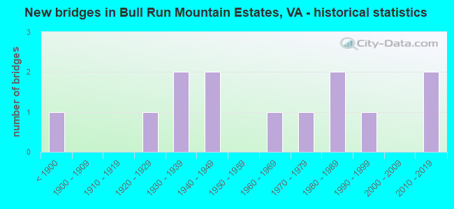
- New bridges - historical statistics
- 1Before 1900
- 11920-1929
- 21930-1939
- 21940-1949
- 11960-1969
- 11970-1979
- 21980-1989
- 11990-1999
- 22010-2019

- Reconstructed bridges - Historical Statistics
- 11980-1989
- 11990-1999


- Bridge Condition - Deck
- 37.5%Good
- 37.5%Satisfactory
- 25.0%Fair

- Bridge Condition - Superstructure
- 30.0%Good
- 40.0%Satisfactory
- 30.0%Fair

- Bridge Condition - Substructure
- 10.0%Very good
- 20.0%Good
- 60.0%Satisfactory
- 10.0%Fair

- Bridge Condition - Channel
- 23.1%Good
- 53.8%Satisfactory
- 23.1%Fair

- Bridge Condition - Culverts
- 33.3%Very good
- 33.3%Satisfactory
- 33.3%Fair
Find on map >> Show street view
Structure Number: 7301, Location: .50FrLoudounCo&1.2To776 (Lat: 38.940675, Lng: -77.674747), Route carried "on" structure: County highway 629, Year Built: 1942, Status: Open, Structure Length: 1.34m (4.40ft), Average Daily Traffic: 69 (year 2019), Average Future Daily Traffic: 76 (year 2040), Features Intersected: Hungry Run, Facility Carried by Structure: Bull Run Mtn Rd
Minimum Vertical Clearance: 30+ m (98+ ft), Kilometerpoint: 10.446, Lanes on structure: 2, Owner: State Highway Agency, Approaching Roadway Width: 4.6m (15.1ft), Skew: 3 degrees, Material/Design: Concrete, Design/Construction: Slab, Number Of Spans In Main Unit: 2, Length of Maximum Span: 6.7m (22.0ft), Curb or Sidewalk Widths: Left: 0.2m (0.7ft), Right: 0.2m (0.7ft), Curb-To-Curb Width: 5.9m (19.4ft), Out-to-Out Width: 6.7m (22.0ft)
Condition: Deck: Satisfactory, Superstructure: Satisfactory, Substructure: Fair, Channel: Satisfactory, Operating Rating: 39.0 metric tons, Method Used To Determine Operating Rating: Load and Resistance Factor (LRFR), Inventory Rating: 29.9 metric tons, Method Used To Determine Inventory Rating: Load and Resistance Factor (LRFR), Structural Evaluation: Somewhat better than minimum adequacy, Deck Geometry: Meets minimum limits, Waterway Adequacy: Equal to present minimum criteria, Approach Roadway Alignment: Equal to present desirable criteria, Length Of Structure Improvement: 1.34m (4.40ft), Designated Inspection Frequency: Every 24 months, Inspection Date: May 2021, Bridge Improvement Cost: $90,000, Roadway Improvement Cost: $10,000, Total Project Cost: $110,000, Deck Structure Type: Concrete Cast-file-Place
Find on map >> Show street view
Structure Number: 11117, Location: 0.35 FR 631 & 0.06 TO 612 (Lat: 38.975250, Lng: -77.639639), Route carried "on" structure: US 50, Year Built: 1824, Year Reconstructed: 2001, Status: Open, Structure Length: 3.29m (10.79ft), Average Daily Traffic: 8,237 (year 2020), Truck Traffic: 3%, Average Future Daily Traffic: 9,061 (year 2040), Design Load: HS 20, Features Intersected: LITTLE RIVER, Facility Carried by Structure: JOHN S. MOSBY HWY.
Minimum Vertical Clearance: 30+ m (98+ ft), Kilometerpoint: 83.105, Lanes on structure: 2, Base Highway Network: Yes, Owner: State Highway Agency, Approaching Roadway Width: 7.6m (24.9ft), Material/Design: Masonry, Design/Construction: Arch - Deck, Number Of Spans In Main Unit: 2, Length of Maximum Span: 9.4m (30.8ft), Curb-To-Curb Width: 5.9m (19.4ft), Out-to-Out Width: 7.0m (23.0ft)
Condition: Superstructure: Fair, Substructure: Satisfactory, Channel: Satisfactory, Operating Rating: 48.6 metric tons, Method Used To Determine Operating Rating: Load Factor (LF), Inventory Rating: 29.7 metric tons, Method Used To Determine Inventory Rating: Load Factor (LF), Structural Evaluation: Somewhat better than minimum adequacy, Deck Geometry: High priority of replacement, Waterway Adequacy: Better than present minimum criteria, Approach Roadway Alignment: Meets minimum limits, Length Of Structure Improvement: 3.29m (10.79ft), Designated Inspection Frequency: Every 24 months, Inspection Date: October 2021, Bridge Improvement Cost: $63,000, Roadway Improvement Cost: $6,000, Total Project Cost: $70,000, Deck Structure Type: Other, Wearing Surface/Protective System: Wearing Surface: Bituminous
Find on map >> Show street view
Structure Number: 11118, Location: 00.45FR631/00.01TO612 (Lat: 38.975400, Lng: -77.640272), Route carried "on" structure: US 50, Year Built: 1929, Status: Open, Structure Length: 0.85m (2.79ft), Average Daily Traffic: 8,237 (year 2020), Truck Traffic: 3%, Average Future Daily Traffic: 9,061 (year 2040), Design Load: HS 20, Features Intersected: MILL RACE, Facility Carried by Structure: JOHN MOSBY HWY.
Minimum Vertical Clearance: 30+ m (98+ ft), Kilometerpoint: 83.040, Lanes on structure: 2, Base Highway Network: Yes, Owner: State Highway Agency, Approaching Roadway Width: 6.7m (22.0ft), Skew: 3 degrees, Material/Design: Concrete, Design/Construction: Tee Beam, Number Of Spans In Main Unit: 1, Length of Maximum Span: 8.5m (27.9ft), Curb or Sidewalk Widths: Left: 0.2m (0.7ft), Right: 0.2m (0.7ft), Curb-To-Curb Width: 7.2m (23.6ft), Out-to-Out Width: 7.9m (25.9ft)
Condition: Deck: Fair, Superstructure: Satisfactory, Substructure: Satisfactory, Channel: Satisfactory, Operating Rating: 56.2 metric tons, Method Used To Determine Operating Rating: Load Factor (LF), Inventory Rating: 33.6 metric tons, Method Used To Determine Inventory Rating: Load Factor (LF), Structural Evaluation: Equal to present minimum criteria, Deck Geometry: High priority of replacement, Waterway Adequacy: Equal to present desirable criteria, Approach Roadway Alignment: Equal to present desirable criteria, Length Of Structure Improvement: 0.85m (2.79ft), Designated Inspection Frequency: Every 24 months, Inspection Date: April 2021, Bridge Improvement Cost: $120,000, Roadway Improvement Cost: $12,000, Total Project Cost: $150,000, Deck Structure Type: Concrete Cast-file-Place, Wearing Surface/Protective System: Wearing Surface: Bituminous
Find on map >> Show street view
Structure Number: 11147, Location: 00.40 15 / 00.15 615 (Lat: 38.936183, Lng: -77.632650), Route carried "on" structure: County highway 600, Year Built: 1993, Status: Open, Structure Length: 0.79m (2.59ft), Average Daily Traffic: 621 (year 2013), Average Future Daily Traffic: 705 (year 2040), Design Load: HS 20, Features Intersected: BULL RUN, Facility Carried by Structure: NEW ROAD
Minimum Vertical Clearance: 30+ m (98+ ft), Kilometerpoint: 0.000, Lanes on structure: 2, Owner: State Highway Agency, Approaching Roadway Width: 6.1m (20.0ft), Skew: 3 degrees, Material/Design: Steel, Design/Construction: Culvert, Number Of Spans In Main Unit: 3, Length of Maximum Span: 2.4m (7.9ft)
Condition: Channel: Fair, Culverts: Fair, Operating Rating: 44.5 metric tons, Method Used To Determine Operating Rating: Field evaluation and documented engineering judgment, Inventory Rating: 32.7 metric tons, Method Used To Determine Inventory Rating: Field evaluation and documented engineering judgment, Structural Evaluation: Somewhat better than minimum adequacy, Waterway Adequacy: Meets minimum limits, Approach Roadway Alignment: Equal to present desirable criteria, Length Of Structure Improvement: 3.75m (12.30ft), Designated Inspection Frequency: Every 24 months, Inspection Date: July 2021, Bridge Improvement Cost: $29,000, Roadway Improvement Cost: $54,000, Total Project Cost: $100,000
Find on map >> Show street view
Structure Number: 11205, Location: 00.10FR50/01.70TODEAD END (Lat: 38.976836, Lng: -77.651317), Route carried "on" structure: County highway 632, Year Built: 1989, Status: Open, Structure Length: 1.37m (4.49ft), Average Daily Traffic: 96 (year 2014), Average Future Daily Traffic: 108 (year 2040), Design Load: HS 20, Features Intersected: LITTLE RIVER, Facility Carried by Structure: ALDIE DAM ROAD
Minimum Vertical Clearance: 30+ m (98+ ft), Kilometerpoint: 2.716, Lanes on structure: 2, Owner: State Highway Agency, Approaching Roadway Width: 4.9m (16.1ft), Skew: 1 degrees, Material/Design: Prestressed concrete, Design/Construction: Slab, Number Of Spans In Main Unit: 1, Length of Maximum Span: 13.7m (44.9ft), Curb or Sidewalk Widths: Left: 0.2m (0.7ft), Right: 0.2m (0.7ft), Curb-To-Curb Width: 7.2m (23.6ft), Out-to-Out Width: 8.2m (26.9ft)
Condition: Deck: Good, Superstructure: Good, Substructure: Good, Channel: Satisfactory, Operating Rating: 72.6 metric tons, Method Used To Determine Operating Rating: Load and Resistance Factor (LRFR), Inventory Rating: 56.2 metric tons, Method Used To Determine Inventory Rating: Load and Resistance Factor (LRFR), Structural Evaluation: Better than present minimum criteria, Deck Geometry: Somewhat better than minimum adequacy, Waterway Adequacy: Equal to present minimum criteria, Approach Roadway Alignment: Meets minimum limits, Length Of Structure Improvement: 1.37m (4.49ft), Designated Inspection Frequency: Every 24 months, Inspection Date: December 2021, Bridge Improvement Cost: $54,000, Roadway Improvement Cost: $89,000, Total Project Cost: $156,000, Deck Structure Type: Concrete Cast-file-Place, Wearing Surface/Protective System: Wearing Surface: Bituminous, Membrane: Epoxy, Deck Protection: Epoxy Coated Reinforcing
Find on map >> Show street view
Structure Number: 14175, Location: 0.02FR615/2.92TO620 (Lat: 38.912736, Lng: -77.628247), Route carried "on" structure: US 15, Year Built: 1935, Year Reconstructed: 1992, Status: Open, Structure Length: 0.72m (2.36ft), Average Daily Traffic: 12,465 (year 2020), Truck Traffic: 5%, Average Future Daily Traffic: 17,451 (year 2040), Design Load: HS 20, Features Intersected: BLACK BRANCH, Facility Carried by Structure: JAMES MADISON HWY.
Minimum Vertical Clearance: 30+ m (98+ ft), Kilometerpoint: 325.356, Lanes on structure: 2, Base Highway Network: Yes, Owner: State Highway Agency, Approaching Roadway Width: 6.4m (21.0ft), Skew: 4 degrees, Material/Design: Concrete, Design/Construction: Slab, Number Of Spans In Main Unit: 1, Length of Maximum Span: 6.5m (21.3ft), Curb-To-Curb Width: 9.3m (30.5ft), Out-to-Out Width: 10.4m (34.1ft)
Condition: Deck: Satisfactory, Superstructure: Satisfactory, Substructure: Satisfactory, Channel: Satisfactory, Operating Rating: 41.2 metric tons, Method Used To Determine Operating Rating: Load and Resistance Factor (LRFR), Inventory Rating: 31.8 metric tons, Method Used To Determine Inventory Rating: Load and Resistance Factor (LRFR), Structural Evaluation: Equal to present minimum criteria, Deck Geometry: High priority of corrective action, Waterway Adequacy: Better than present minimum criteria, Approach Roadway Alignment: Better than present minimum criteria, Length Of Structure Improvement: 1.83m (6.00ft), Designated Inspection Frequency: Every 24 months, Inspection Date: June 2021, Bridge Improvement Cost: $85,000, Roadway Improvement Cost: $20,000, Total Project Cost: $175,000, Deck Structure Type: Concrete Cast-file-Place, Wearing Surface/Protective System: Wearing Surface: Bituminous
Find on map >> Show street view
Structure Number: 14182, Location: 01.50FR615/0.34TO600 (Lat: 38.931689, Lng: -77.625036), Route carried "on" structure: US 15, Year Built: 1933, Status: Open, Structure Length: 0.79m (2.59ft), Average Daily Traffic: 12,465 (year 2020), Truck Traffic: 5%, Average Future Daily Traffic: 17,451 (year 2040), Design Load: HS 20, Features Intersected: BULL RUN, Facility Carried by Structure: JAMES MADISON HWY
Minimum Vertical Clearance: 30+ m (98+ ft), Kilometerpoint: 327.464, Lanes on structure: 2, Base Highway Network: Yes, Owner: State Highway Agency, Approaching Roadway Width: 13.4m (44.0ft), Skew: 3 degrees, Material/Design: Concrete, Design/Construction: Slab, Number Of Spans In Main Unit: 1, Length of Maximum Span: 7.3m (24.0ft), Curb-To-Curb Width: 13.4m (44.0ft), Out-to-Out Width: 14.6m (47.9ft)
Condition: Deck: Fair, Superstructure: Fair, Substructure: Satisfactory, Channel: Good, Operating Rating: 45.5 metric tons, Method Used To Determine Operating Rating: Load and Resistance Factor (LRFR), Inventory Rating: 35.2 metric tons, Method Used To Determine Inventory Rating: Load and Resistance Factor (LRFR), Structural Evaluation: Somewhat better than minimum adequacy, Deck Geometry: Equal to present minimum criteria, Waterway Adequacy: Equal to present minimum criteria, Approach Roadway Alignment: Equal to present desirable criteria, Length Of Structure Improvement: 3.05m (10.01ft), Designated Inspection Frequency: Every 24 months, Inspection Date: December 2020, Bridge Improvement Cost: $25,000, Roadway Improvement Cost: $15,000, Total Project Cost: $50,000 ( Estimate for 2014), Deck Structure Type: Concrete Cast-file-Place, Wearing Surface/Protective System: Wearing Surface: Bituminous
Find on map >> Show street view
Structure Number: 14292, Location: 0.21 FR 731 & 0.30 TO 680 (Lat: 38.862028, Lng: -77.667200), Route carried "on" structure: County highway 601, Year Built: 1961, Status: Posted for load, Structure Length: 0.73m (2.40ft), Average Daily Traffic: 1,205 (year 2020), Average Future Daily Traffic: 1,326 (year 2040), Design Load: HS 20, Features Intersected: CATHARPIN CREEK, Facility Carried by Structure: WATERFALL ROAD
Minimum Vertical Clearance: 30+ m (98+ ft), Kilometerpoint: 4.023, Lanes on structure: 2, Owner: State Highway Agency, Approaching Roadway Width: 4.9m (16.1ft), Material/Design: Steel, Design/Construction: Stringer/Multi-beam, Number Of Spans In Main Unit: 1, Length of Maximum Span: 6.7m (22.0ft), Curb-To-Curb Width: 6.1m (20.0ft), Out-to-Out Width: 6.7m (22.0ft)
Condition: Deck: Satisfactory, Superstructure: Fair, Substructure: Satisfactory, Channel: Fair, Operating Rating: 35.8 metric tons, Method Used To Determine Operating Rating: Load and Resistance Factor (LRFR), Inventory Rating: 27.7 metric tons, Method Used To Determine Inventory Rating: Load and Resistance Factor (LRFR), Structural Evaluation: Somewhat better than minimum adequacy, Deck Geometry: High priority of replacement, Waterway Adequacy: High priority of corrective action, Approach Roadway Alignment: Better than present minimum criteria, Length Of Structure Improvement: 1.52m (4.99ft), Designated Inspection Frequency: Every 24 months, Inspection Date: April 2020, Bridge Improvement Cost: $180,000, Roadway Improvement Cost: $100,000, Total Project Cost: $300,000, Deck Structure Type: Wood or Timber, Wearing Surface/Protective System: Wearing Surface: Bituminous
Find on map >> Show street view
Structure Number: 14371, Location: 01.10 15 / 00.71 701 (Lat: 38.889689, Lng: -77.629086), Route carried "on" structure: County highway 686, Year Built: 1988, Status: Open, Structure Length: 1.55m (5.09ft), Average Daily Traffic: 185 (year 2013), Average Future Daily Traffic: 210 (year 2040), Design Load: HS 20, Features Intersected: CHESTNUT LICK RUN, Facility Carried by Structure: INGRAM DRIVE
Minimum Vertical Clearance: 30+ m (98+ ft), Kilometerpoint: 1.770, Lanes on structure: 2, Owner: State Highway Agency, Approaching Roadway Width: 7.3m (24.0ft), Skew: 2 degrees, Material/Design: Prestressed concrete, Design/Construction: Slab, Number Of Spans In Main Unit: 1, Length of Maximum Span: 14.9m (48.9ft), Curb-To-Curb Width: 7.2m (23.6ft), Out-to-Out Width: 8.2m (26.9ft)
Condition: Deck: Good, Superstructure: Good, Substructure: Good, Channel: Good, Operating Rating: 74.4 metric tons, Method Used To Determine Operating Rating: Load and Resistance Factor (LRFR), Inventory Rating: 57.2 metric tons, Method Used To Determine Inventory Rating: Load and Resistance Factor (LRFR), Structural Evaluation: Better than present minimum criteria, Deck Geometry: Meets minimum limits, Waterway Adequacy: Equal to present desirable criteria, Approach Roadway Alignment: Equal to present minimum criteria, Length Of Structure Improvement: 1.52m (4.99ft), Designated Inspection Frequency: Every 24 months, Inspection Date: November 2020, Bridge Improvement Cost: $22,000, Roadway Improvement Cost: $44,000, Total Project Cost: $100,000 ( Estimate for 2014), Deck Structure Type: Concrete Precast Panels, Wearing Surface/Protective System: Wearing Surface: Bituminous
Find on map >> Show street view
Structure Number: 14429, Location: 00.40FR2010/00.40TO END (Lat: 38.876981, Lng: -77.661803), Route carried "on" structure: County highway 2013, Year Built: 1974, Status: Open, Structure Length: 0.61m (2.00ft), Average Daily Traffic: 276 (year 2013), Average Future Daily Traffic: 386 (year 2040), Design Load: HS 20, Features Intersected: CHESTNUT LICK BRANCH, Facility Carried by Structure: DELASHMUTT DR.
Minimum Vertical Clearance: 30+ m (98+ ft), Kilometerpoint: 0.595, Lanes on structure: 2, Owner: State Highway Agency, Approaching Roadway Width: 9.4m (30.8ft), Material/Design: Steel, Design/Construction: Culvert, Number Of Spans In Main Unit: 2, Length of Maximum Span: 3.0m (9.8ft)
Condition: Channel: Good, Culverts: Satisfactory, Operating Rating: 44.5 metric tons, Method Used To Determine Operating Rating: Allowable Stress (AS), Inventory Rating: 32.7 metric tons, Method Used To Determine Inventory Rating: Allowable Stress (AS), Structural Evaluation: Equal to present minimum criteria, Waterway Adequacy: Better than present minimum criteria, Approach Roadway Alignment: Equal to present minimum criteria, Length Of Structure Improvement: 0.30m (0.98ft), Designated Inspection Frequency: Every 24 months, Inspection Date: April 2021, Bridge Improvement Cost: $1,000, Roadway Improvement Cost: $1,000, Total Project Cost: $3,000 ( Estimate for 2015)
Find on map >> Show street view
Structure Number: 23618, Location: 00.84FR.701/00.83TO686 (Lat: 38.888378, Lng: -77.632417), Route carried "on" structure: US 15, Year Built: 1941, Status: Open, Structure Length: 1.31m (4.30ft), Average Daily Traffic: 14,133 (year 2020), Truck Traffic: 5%, Average Future Daily Traffic: 19,786 (year 2040), Design Load: HS 20+Mod, Features Intersected: CHESTNUT LICK CREEK, Facility Carried by Structure: JAMES MADISON HWY
Minimum Vertical Clearance: 30+ m (98+ ft), Kilometerpoint: 322.624, Lanes on structure: 2, Base Highway Network: Yes, Owner: State Highway Agency, Approaching Roadway Width: 9.1m (29.9ft), Material/Design: Prestressed concrete, Design/Construction: Slab, Number Of Spans In Main Unit: 1, Length of Maximum Span: 13.1m (43.0ft), Curb-To-Curb Width: 9.4m (30.8ft), Out-to-Out Width: 10.6m (34.8ft)
Condition: Deck: Good, Superstructure: Satisfactory, Substructure: Satisfactory, Channel: Satisfactory, Operating Rating: 64.8 metric tons, Method Used To Determine Operating Rating: Load and Resistance Factor (LRFR), Inventory Rating: 50.0 metric tons, Method Used To Determine Inventory Rating: Load and Resistance Factor (LRFR), Structural Evaluation: Equal to present minimum criteria, Deck Geometry: High priority of corrective action, Waterway Adequacy: Better than present minimum criteria, Approach Roadway Alignment: Equal to present desirable criteria, Length Of Structure Improvement: 1.31m (4.30ft), Designated Inspection Frequency: Every 24 months, Inspection Date: April 2021, Bridge Improvement Cost: $55,000, Roadway Improvement Cost: $79,000, Total Project Cost: $150,000 ( Estimate for 2015), Deck Structure Type: Concrete Precast Panels, Wearing Surface/Protective System: Wearing Surface: Bituminous, Membrane: Epoxy, Deck Protection: Epoxy Coated Reinforcing
Find on map >> Show street view
Structure Number: 30048, Location: 0.73 fr 601 0.01 to 680 (Lat: 38.869889, Lng: -77.683889), Route carried "on" structure: Alternate County highway 600, Year Built: 2012, Status: Open, Structure Length: 0.78m (2.56ft), Average Daily Traffic: 507 (year 2013), Average Future Daily Traffic: 575 (year 2040), Design Load: HS 20+Mod, Features Intersected: CATHARPIN CREEK, Facility Carried by Structure: Mountain Road
Minimum Vertical Clearance: 30.18m (99.02ft), Kilometerpoint: 0.000, Lanes on structure: 2, Owner: State Highway Agency, Approaching Roadway Width: 8.5m (27.9ft), Skew: 2 degrees, Material/Design: Concrete, Design/Construction: Arch - Deck, Number Of Spans In Main Unit: 1, Length of Maximum Span: 7.2m (23.6ft), Curb-To-Curb Width: 9.1m (29.9ft), Out-to-Out Width: 18.3m (60.0ft)
Condition: Superstructure: Good, Substructure: Very good, Channel: Fair, Operating Rating: 63.1 metric tons, Method Used To Determine Operating Rating: Load and Resistance Factor (LRFR), Inventory Rating: 54.6 metric tons, Method Used To Determine Inventory Rating: Load and Resistance Factor (LRFR), Structural Evaluation: Better than present minimum criteria, Deck Geometry: Equal to present minimum criteria, Waterway Adequacy: Equal to present minimum criteria, Approach Roadway Alignment: Equal to present desirable criteria, Length Of Structure Improvement: 0.30m (0.98ft), Designated Inspection Frequency: Every 24 months, Inspection Date: November 2020, Bridge Improvement Cost: $1,000, Roadway Improvement Cost: $1,000, Total Project Cost: $3,000 ( Estimate for 2014), Deck Structure Type: Concrete Cast-file-Place, Wearing Surface/Protective System: Wearing Surface: Bituminous, Membrane: Preformed Fabric, Deck Protection: Epoxy Coated Reinforcing
Find on map >> Show street view
Structure Number: 30343, Location: 1.23fr15 0.28to600 (Lat: 38.903431, Lng: -77.654147), Route carried "on" structure: Alternate County highway 701, Year Built: 2015, Status: Open, Structure Length: 0.67m (2.20ft), Average Daily Traffic: 2,444 (year 2013), Truck Traffic: 2%, Average Future Daily Traffic: 3,764 (year 2040), Design Load: HS 20, Features Intersected: CHESTNUT LICK, Facility Carried by Structure: LOGMILL ROAD
Minimum Vertical Clearance: 30.18m (99.02ft), Kilometerpoint: 0.000, Lanes on structure: 2, Owner: State Highway Agency, Approaching Roadway Width: 7.9m (25.9ft), Material/Design: Concrete, Design/Construction: Culvert, Number Of Spans In Main Unit: 2, Length of Maximum Span: 3.0m (9.8ft)
Condition: Channel: Satisfactory, Culverts: Very good, Operating Rating: 86.2 metric tons, Method Used To Determine Operating Rating: Load Factor (LF), Inventory Rating: 51.7 metric tons, Method Used To Determine Inventory Rating: Load Factor (LF), Structural Evaluation: Equal to present desirable criteria, Waterway Adequacy: Better than present minimum criteria, Approach Roadway Alignment: Better than present minimum criteria, Designated Inspection Frequency: Every 24 months, Inspection Date: January 2022