Bridge Statistics for Burlington, Oklahoma (OK)
Condition, Traffic, Stress, Structural Evaluation, Project Costs
- National Bridge Inventory (NBI) Statistics
- 19Number of bridges
- 115ft / 34.6mTotal length
- $7,826,000Total costs
- 5,600Total average daily traffic
- 778Total average daily truck traffic
- 8,960Total future (year 2040) average daily traffic
- National Bridge Inventory (NBI) Registered Bridges for Burlington
- No street view available for this location
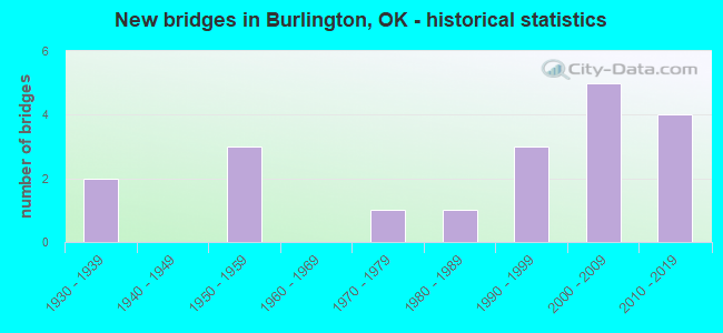
- New bridges - historical statistics
- 21930-1939
- 31950-1959
- 11970-1979
- 11980-1989
- 31990-1999
- 52000-2009
- 42010-2019

- Bridge Condition - Deck
- 17.6%Very good
- 41.2%Good
- 35.3%Satisfactory
- 5.9%Failed

- Bridge Condition - Superstructure
- 23.5%Very good
- 11.8%Good
- 58.8%Satisfactory
- 5.9%Failed

- Bridge Condition - Substructure
- 11.8%Very good
- 23.5%Good
- 58.8%Satisfactory
- 5.9%Failed

- Bridge Condition - Channel
- 10.5%Very good
- 52.6%Good
- 31.6%Satisfactory
- 5.3%Fair
Find on map >> Show street view
Structure Number: 4454, Location: 1S OF BURLINGTON (Lat: 36.884497, Lng: -98.427028), Route carried "on" structure: County highway E0090, Year Built: 1935, Status: Open, Structure Length: 1.28m (4.20ft), Average Daily Traffic: 50 (year 2020), Truck Traffic: 10%, Average Future Daily Traffic: 80 (year 2040), Design Load: HS 20, Features Intersected: DRIFTWOOD CREEK
Minimum Vertical Clearance: 30+ m (98+ ft), Kilometerpoint: 0.483, Lanes on structure: 2, Owner: County Highway Agency, Approaching Roadway Width: 5.5m (18.0ft), Material/Design: Steel, Design/Construction: Stringer/Multi-beam, Number Of Spans In Main Unit: 1, Length of Maximum Span: 12.8m (42.0ft), Curb-To-Curb Width: 5.5m (18.0ft), Out-to-Out Width: 6.5m (21.3ft)
Condition: Deck: Satisfactory, Superstructure: Satisfactory, Substructure: Satisfactory, Channel: Satisfactory, Operating Rating: 50.8 metric tons, Method Used To Determine Operating Rating: Allowable Stress (AS), Inventory Rating: 29.9 metric tons, Method Used To Determine Inventory Rating: Allowable Stress (AS), Structural Evaluation: Equal to present minimum criteria, Deck Geometry: Meets minimum limits, Waterway Adequacy: Better than present minimum criteria, Approach Roadway Alignment: Meets minimum limits, Length Of Structure Improvement: 3.93m (12.89ft), Designated Inspection Frequency: Every 24 months, Inspection Date: July 2021, Bridge Improvement Cost: $201,000, Roadway Improvement Cost: $110,000, Total Project Cost: $319,000 ( Estimate for 2015), Deck Structure Type: Concrete Cast-file-Place, Wearing Surface/Protective System: Wearing Surface: Monolithic Concrete
Find on map >> Show street view
Structure Number: 5176, Location: 4N OF BURLINGTON (Lat: 36.956817, Lng: -98.420817), Route carried "on" structure: County highway E0040, Year Built: 1937, Status: Temporarily open, Structure Length: 0.61m (2.00ft), Average Daily Traffic: 100 (year 2020), Truck Traffic: 10%, Average Future Daily Traffic: 160 (year 2040), Design Load: HS 20, Features Intersected: CREEK
Minimum Vertical Clearance: 30+ m (98+ ft), Kilometerpoint: 1.287, Lanes on structure: 2, Owner: County Highway Agency, Approaching Roadway Width: 6.1m (20.0ft), Material/Design: Steel, Design/Construction: Stringer/Multi-beam, Number Of Spans In Main Unit: 1, Length of Maximum Span: 6.1m (20.0ft), Curb-To-Curb Width: 6.1m (20.0ft), Out-to-Out Width: 6.6m (21.7ft)
Condition: Deck: Failed, Superstructure: Failed, Substructure: Failed, Channel: Satisfactory, Deck Geometry: Somewhat better than minimum adequacy, Waterway Adequacy: High priority of corrective action, Approach Roadway Alignment: Equal to present desirable criteria, Length Of Structure Improvement: 2.66m (8.73ft), Designated Inspection Frequency: Every 12 months, Inspection Date: June 2021, Bridge Improvement Cost: $136,000, Roadway Improvement Cost: $75,000, Total Project Cost: $225,000 ( Estimate for 2015), Deck Structure Type: Concrete Cast-file-Place, Wearing Surface/Protective System: Wearing Surface: Other
Find on map >> Show street view
Structure Number: 12893, Location: 8 M. E. OF WOODS C/L (Lat: 36.899158, Lng: -98.395983), Route carried "on" structure: State highway 8, Year Built: 1953, Status: Open, Structure Length: 0.73m (2.40ft), Average Daily Traffic: 1,400 (year 2020), Truck Traffic: 15%, Average Future Daily Traffic: 2,240 (year 2040), Design Load: HS 20, Features Intersected: CREEK
Minimum Vertical Clearance: 30+ m (98+ ft), Kilometerpoint: 14.545, Lanes on structure: 2, Owner: State Highway Agency, Approaching Roadway Width: 8.2m (26.9ft), Skew: 3 degrees, Material/Design: Concrete, Design/Construction: Culvert, Number Of Spans In Main Unit: 2, Length of Maximum Span: 3.0m (9.8ft), Curb-To-Curb Width: 9.9m (32.5ft), Out-to-Out Width: 10.5m (34.4ft)
Condition: Channel: Good, Culverts: Satisfactory, Operating Rating: 42.1 metric tons, Method Used To Determine Operating Rating: Load Factor (LF), Inventory Rating: 25.3 metric tons, Method Used To Determine Inventory Rating: Load Factor (LF), Structural Evaluation: Equal to present minimum criteria, Deck Geometry: Somewhat better than minimum adequacy, Waterway Adequacy: Better than present minimum criteria, Approach Roadway Alignment: Equal to present desirable criteria, Length Of Structure Improvement: 0.73m (2.40ft), Designated Inspection Frequency: Every 24 months, Inspection Date: October 2021, Bridge Improvement Cost: $230,000, Roadway Improvement Cost: $380,000, Total Project Cost: $644,000 ( Estimate for 2015)
Find on map >> Show street view
Structure Number: 12939, Location: 8.0 MI.N&W.JCT.US64 (Lat: 36.899175, Lng: -98.377925), Route carried "on" structure: State highway 8, Year Built: 1953, Status: Open, Structure Length: 1.13m (3.71ft), Average Daily Traffic: 1,400 (year 2020), Truck Traffic: 15%, Average Future Daily Traffic: 2,240 (year 2040), Design Load: HS 20, Features Intersected: CREEK
Minimum Vertical Clearance: 30+ m (98+ ft), Kilometerpoint: 12.936, Lanes on structure: 2, Owner: State Highway Agency, Approaching Roadway Width: 8.2m (26.9ft), Skew: 3 degrees, Material/Design: Concrete, Design/Construction: Culvert, Number Of Spans In Main Unit: 3, Length of Maximum Span: 3.0m (9.8ft), Curb-To-Curb Width: 9.9m (32.5ft), Out-to-Out Width: 10.4m (34.1ft)
Condition: Channel: Fair, Culverts: Satisfactory, Operating Rating: 39.2 metric tons, Method Used To Determine Operating Rating: Load Factor (LF), Inventory Rating: 23.5 metric tons, Method Used To Determine Inventory Rating: Load Factor (LF), Structural Evaluation: Equal to present minimum criteria, Deck Geometry: Somewhat better than minimum adequacy, Waterway Adequacy: Superior to present desirable criteria, Approach Roadway Alignment: Equal to present desirable criteria, Length Of Structure Improvement: 1.13m (3.71ft), Designated Inspection Frequency: Every 24 months, Inspection Date: October 2021, Bridge Improvement Cost: $230,000, Roadway Improvement Cost: $380,000, Total Project Cost: $644,000 ( Estimate for 2015)
Find on map >> Show street view
Structure Number: 13041, Location: 3.3 W JCT S.H. 58 (Lat: 36.899078, Lng: -98.419164), Route carried "on" structure: State highway 8, Year Built: 1953, Year Reconstructed: 2016, Status: Open, Structure Length: 3.81m (12.50ft), Average Daily Traffic: 1,400 (year 2020), Truck Traffic: 15%, Average Future Daily Traffic: 2,240 (year 2040), Design Load: HL 93, Features Intersected: STINK CREEK
Minimum Vertical Clearance: 30+ m (98+ ft), Kilometerpoint: 16.605, Lanes on structure: 2, Owner: State Highway Agency, Approaching Roadway Width: 8.2m (26.9ft), Material/Design: Concrete, Design/Construction: Slab, Number Of Spans In Main Unit: 5, Length of Maximum Span: 7.6m (24.9ft), Curb-To-Curb Width: 9.1m (29.9ft), Out-to-Out Width: 9.8m (32.2ft)
Condition: Deck: Very good, Superstructure: Very good, Substructure: Very good, Channel: Good, Operating Rating: 49.4 metric tons, Method Used To Determine Operating Rating: Load and Resistance Factor (LRFR), Inventory Rating: 38.1 metric tons, Method Used To Determine Inventory Rating: Load and Resistance Factor (LRFR), Structural Evaluation: Equal to present desirable criteria, Deck Geometry: Somewhat better than minimum adequacy, Waterway Adequacy: Equal to present desirable criteria, Approach Roadway Alignment: Equal to present desirable criteria, Length Of Structure Improvement: 7.01m (23.00ft), Designated Inspection Frequency: Every 24 months, Inspection Date: October 2021, Bridge Improvement Cost: $590,000, Roadway Improvement Cost: $973,000, Total Project Cost: $1,651,000 ( Estimate for 2015), Deck Structure Type: Concrete Cast-file-Place, Wearing Surface/Protective System: Wearing Surface: Bituminous
Find on map >> Show street view
Structure Number: 18752, Location: 4.8N OF US 64 (Lat: 36.866439, Lng: -98.413994), Route carried "on" structure: County highway N2580, Year Built: 1974, Status: Open, Structure Length: 6.10m (20.01ft), Average Daily Traffic: 50 (year 2020), Truck Traffic: 15%, Average Future Daily Traffic: 80 (year 2040), Design Load: HS 20, Features Intersected: DRIFTWOOD CREEK
Minimum Vertical Clearance: 30+ m (98+ ft), Kilometerpoint: 12.550, Lanes on structure: 2, Owner: County Highway Agency, Approaching Roadway Width: 6.7m (22.0ft), Material/Design: Concrete, Design/Construction: Tee Beam, Number Of Spans In Main Unit: 5, Length of Maximum Span: 12.2m (40.0ft), Curb-To-Curb Width: 7.5m (24.6ft), Out-to-Out Width: 8.3m (27.2ft)
Condition: Deck: Satisfactory, Superstructure: Good, Substructure: Satisfactory, Channel: Satisfactory, Operating Rating: 43.5 metric tons, Method Used To Determine Operating Rating: Allowable Stress (AS), Inventory Rating: 32.7 metric tons, Method Used To Determine Inventory Rating: Allowable Stress (AS), Structural Evaluation: Equal to present minimum criteria, Deck Geometry: Equal to present minimum criteria, Waterway Adequacy: Better than present minimum criteria, Approach Roadway Alignment: Equal to present desirable criteria, Length Of Structure Improvement: 9.00m (29.53ft), Designated Inspection Frequency: Every 24 months, Inspection Date: July 2021, Bridge Improvement Cost: $460,000, Roadway Improvement Cost: $253,000, Total Project Cost: $716,000 ( Estimate for 2015), Deck Structure Type: Concrete Cast-file-Place, Wearing Surface/Protective System: Wearing Surface: Bituminous
Find on map >> Show street view
Structure Number: 21575, Location: 1.5W .1N OF BURLING (Lat: 36.900858, Lng: -98.449803), Route carried "on" structure: County highway N2560, Year Built: 1987, Status: Open, Structure Length: 2.29m (7.51ft), Average Daily Traffic: 100 (year 2020), Truck Traffic: 10%, Average Future Daily Traffic: 160 (year 2040), Design Load: HS 20, Features Intersected: DRIFTWOOD CREEK
Minimum Vertical Clearance: 30+ m (98+ ft), Kilometerpoint: 1.448, Lanes on structure: 2, Owner: County Highway Agency, Approaching Roadway Width: 7.9m (25.9ft), Material/Design: Prestressed concrete, Design/Construction: Stringer/Multi-beam, Number Of Spans In Main Unit: 1, Length of Maximum Span: 22.9m (75.1ft), Curb-To-Curb Width: 7.9m (25.9ft), Out-to-Out Width: 8.7m (28.5ft)
Condition: Deck: Good, Superstructure: Very good, Substructure: Very good, Channel: Good, Operating Rating: 73.5 metric tons, Method Used To Determine Operating Rating: Load Factor (LF), Inventory Rating: 35.4 metric tons, Method Used To Determine Inventory Rating: Load Factor (LF), Structural Evaluation: Equal to present desirable criteria, Deck Geometry: Equal to present minimum criteria, Waterway Adequacy: Somewhat better than minimum adequacy, Approach Roadway Alignment: Equal to present desirable criteria, Length Of Structure Improvement: 5.35m (17.55ft), Designated Inspection Frequency: Every 24 months, Inspection Date: March 2021, Bridge Improvement Cost: $273,000, Roadway Improvement Cost: $150,000, Total Project Cost: $436,000 ( Estimate for 2015), Deck Structure Type: Concrete Cast-file-Place, Wearing Surface/Protective System: Wearing Surface: Monolithic Concrete
Find on map >> Show street view
Structure Number: 22534, Location: MI WEST OF SH-58 (Lat: 36.884514, Lng: -98.367214), Route carried "on" structure: County highway E0090, Year Built: 1990, Status: Posted for load, Structure Length: 1.46m (4.79ft), Average Daily Traffic: 100 (year 2020), Truck Traffic: 10%, Average Future Daily Traffic: 160 (year 2040), Design Load: HS 20, Features Intersected: STINK CREEK
Minimum Vertical Clearance: 30+ m (98+ ft), Kilometerpoint: 0.966, Lanes on structure: 2, Owner: County Highway Agency, Approaching Roadway Width: 4.9m (16.1ft), Material/Design: Steel continuous, Design/Construction: Stringer/Multi-beam, Number Of Spans In Main Unit: 3, Length of Maximum Span: 4.9m (16.1ft), Curb-To-Curb Width: 6.2m (20.3ft), Out-to-Out Width: 6.3m (20.7ft)
Condition: Deck: Satisfactory, Superstructure: Satisfactory, Substructure: Satisfactory, Channel: Satisfactory, Operating Rating: 24.5 metric tons, Method Used To Determine Operating Rating: Load Factor (LF), Inventory Rating: 14.5 metric tons, Method Used To Determine Inventory Rating: Load Factor (LF), Structural Evaluation: Meets minimum limits, Deck Geometry: Somewhat better than minimum adequacy, Waterway Adequacy: Equal to present desirable criteria, Approach Roadway Alignment: Equal to present desirable criteria, Bridge Posting: Required (Relationship of Operating Rating to Maximum Legal Load: 30.0 - 39.9% below), Length Of Structure Improvement: 4.22m (13.85ft), Designated Inspection Frequency: Every 24 months, Inspection Date: August 2021, Bridge Improvement Cost: $215,000, Roadway Improvement Cost: $118,000, Total Project Cost: $342,000 ( Estimate for 2015), Deck Structure Type: Concrete Cast-file-Place, Wearing Surface/Protective System: Wearing Surface: Monolithic Concrete
Find on map >> Show street view
Structure Number: 24528, Location: 6.8N OF US 64 (Lat: 36.895950, Lng: -98.413922), Route carried "on" structure: County highway N2580, Year Built: 1993, Status: Open, Structure Length: 1.52m (4.99ft), Average Daily Traffic: 50 (year 2020), Truck Traffic: 15%, Average Future Daily Traffic: 80 (year 2040), Design Load: HS 20, Features Intersected: STINK CREEK
Minimum Vertical Clearance: 30+ m (98+ ft), Kilometerpoint: 15.768, Lanes on structure: 2, Owner: County Highway Agency, Approaching Roadway Width: 9.1m (29.9ft), Material/Design: Steel continuous, Design/Construction: Stringer/Multi-beam, Number Of Spans In Main Unit: 2, Length of Maximum Span: 7.6m (24.9ft), Curb-To-Curb Width: 7.0m (23.0ft), Out-to-Out Width: 7.0m (23.0ft)
Condition: Deck: Good, Superstructure: Satisfactory, Substructure: Satisfactory, Channel: Good, Operating Rating: 56.2 metric tons, Method Used To Determine Operating Rating: Load Factor (LF), Inventory Rating: 33.6 metric tons, Method Used To Determine Inventory Rating: Load Factor (LF), Structural Evaluation: Equal to present minimum criteria, Deck Geometry: Somewhat better than minimum adequacy, Waterway Adequacy: Equal to present minimum criteria, Approach Roadway Alignment: Equal to present desirable criteria, Length Of Structure Improvement: 4.31m (14.14ft), Designated Inspection Frequency: Every 24 months, Inspection Date: July 2021, Bridge Improvement Cost: $220,000, Roadway Improvement Cost: $121,000, Total Project Cost: $350,000 ( Estimate for 2015), Deck Structure Type: Concrete Cast-file-Place, Wearing Surface/Protective System: Wearing Surface: Bituminous
Find on map >> Show street view
Structure Number: 24529, Location: 1W .5S OF JCT SH8/SH58 (Lat: 36.892261, Lng: -98.377689), Route carried "on" structure: County highway N2600, Year Built: 1993, Status: Posted for load, Structure Length: 1.53m (5.02ft), Average Daily Traffic: 100 (year 2020), Truck Traffic: 10%, Average Future Daily Traffic: 160 (year 2040), Design Load: HS 20, Features Intersected: STINK CREEK
Minimum Vertical Clearance: 30+ m (98+ ft), Kilometerpoint: 0.805, Lanes on structure: 2, Owner: County Highway Agency, Approaching Roadway Width: 7.3m (24.0ft), Material/Design: Steel, Design/Construction: Stringer/Multi-beam, Number Of Spans In Main Unit: 2, Length of Maximum Span: 7.7m (25.3ft), Curb-To-Curb Width: 7.6m (24.9ft), Out-to-Out Width: 7.9m (25.9ft)
Condition: Deck: Satisfactory, Superstructure: Satisfactory, Substructure: Satisfactory, Channel: Satisfactory, Operating Rating: 23.6 metric tons, Method Used To Determine Operating Rating: Load Factor (LF), Inventory Rating: 13.6 metric tons, Method Used To Determine Inventory Rating: Load Factor (LF), Structural Evaluation: Meets minimum limits, Deck Geometry: Equal to present minimum criteria, Waterway Adequacy: Better than present minimum criteria, Approach Roadway Alignment: Equal to present desirable criteria, Bridge Posting: Required (Relationship of Operating Rating to Maximum Legal Load: 30.0 - 39.9% below), Length Of Structure Improvement: 4.31m (14.14ft), Designated Inspection Frequency: Every 24 months, Inspection Date: August 2021, Bridge Improvement Cost: $220,000, Roadway Improvement Cost: $121,000, Total Project Cost: $350,000 ( Estimate for 2015), Deck Structure Type: Concrete Cast-file-Place, Wearing Surface/Protective System: Wearing Surface: Monolithic Concrete
Find on map >> Show street view
Structure Number: 27184, Location: 2.5W 1.3S OF BURLINGTON (Lat: 36.879928, Lng: -98.467897), Route carried "on" structure: County highway N2550, Year Built: 2002, Status: Open, Structure Length: 1.86m (6.10ft), Average Daily Traffic: 100 (year 2020), Truck Traffic: 10%, Average Future Daily Traffic: 160 (year 2040), Design Load: H 20, Features Intersected: DRY CREEK
Minimum Vertical Clearance: 30+ m (98+ ft), Kilometerpoint: 0.483, Lanes on structure: 2, Owner: County Highway Agency, Approaching Roadway Width: 7.0m (23.0ft), Material/Design: Steel continuous, Design/Construction: Stringer/Multi-beam, Number Of Spans In Main Unit: 2, Length of Maximum Span: 9.3m (30.5ft), Curb-To-Curb Width: 7.0m (23.0ft), Out-to-Out Width: 7.9m (25.9ft)
Condition: Deck: Satisfactory, Superstructure: Satisfactory, Substructure: Good, Channel: Good, Operating Rating: 88.0 metric tons, Method Used To Determine Operating Rating: Load Factor (LF), Inventory Rating: 52.6 metric tons, Method Used To Determine Inventory Rating: Load Factor (LF), Structural Evaluation: Equal to present minimum criteria, Deck Geometry: Somewhat better than minimum adequacy, Waterway Adequacy: Equal to present minimum criteria, Approach Roadway Alignment: Better than present minimum criteria, Length Of Structure Improvement: 3.05m (10.01ft), Designated Inspection Frequency: Every 24 months, Inspection Date: July 2021, Bridge Improvement Cost: $249,000, Roadway Improvement Cost: $124,000, Total Project Cost: $414,000 ( Estimate for 2015), Deck Structure Type: Concrete Cast-file-Place, Wearing Surface/Protective System: Wearing Surface: Monolithic Concrete
Find on map >> Show street view
Structure Number: 27185, Location: 1.4S 1.5W OF BURLINGTON (Lat: 36.878203, Lng: -98.449897), Route carried "on" structure: County highway N2560, Year Built: 2002, Status: Open, Structure Length: 1.86m (6.10ft), Average Daily Traffic: 75 (year 2020), Truck Traffic: 10%, Average Future Daily Traffic: 120 (year 2040), Design Load: H 20, Features Intersected: DRIFTWOOD CREEK TRIB.
Minimum Vertical Clearance: 30+ m (98+ ft), Kilometerpoint: 0.644, Lanes on structure: 2, Owner: County Highway Agency, Approaching Roadway Width: 7.0m (23.0ft), Material/Design: Steel, Design/Construction: Stringer/Multi-beam, Number Of Spans In Main Unit: 2, Length of Maximum Span: 9.3m (30.5ft), Curb-To-Curb Width: 7.0m (23.0ft), Out-to-Out Width: 7.9m (25.9ft)
Condition: Deck: Good, Superstructure: Satisfactory, Substructure: Satisfactory, Channel: Good, Operating Rating: 88.0 metric tons, Method Used To Determine Operating Rating: Load Factor (LF), Inventory Rating: 52.6 metric tons, Method Used To Determine Inventory Rating: Load Factor (LF), Structural Evaluation: Equal to present minimum criteria, Deck Geometry: Somewhat better than minimum adequacy, Waterway Adequacy: Equal to present minimum criteria, Approach Roadway Alignment: Better than present minimum criteria, Length Of Structure Improvement: 3.05m (10.01ft), Designated Inspection Frequency: Every 24 months, Inspection Date: July 2021, Bridge Improvement Cost: $249,000, Roadway Improvement Cost: $124,000, Total Project Cost: $414,000 ( Estimate for 2015), Deck Structure Type: Concrete Cast-file-Place, Wearing Surface/Protective System: Wearing Surface: Monolithic Concrete
Find on map >> Show street view
Structure Number: 28054, Location: .5W .7S OF BULRINGTON (Lat: 36.888611, Lng: -98.431944), Route carried "on" structure: County highway N2570, Year Built: 2008, Status: Posted for load, Structure Length: 2.74m (8.99ft), Average Daily Traffic: 100 (year 2020), Truck Traffic: 10%, Average Future Daily Traffic: 160 (year 2040), Design Load: HS 20, Features Intersected: DRIFTWOOD CREEK
Minimum Vertical Clearance: 30+ m (98+ ft), Kilometerpoint: 1.127, Lanes on structure: 2, Owner: County Highway Agency, Approaching Roadway Width: 7.3m (24.0ft), Skew: 3 degrees, Material/Design: Prestressed concrete, Design/Construction: Tee Beam, Number Of Spans In Main Unit: 3, Length of Maximum Span: 9.1m (29.9ft), Curb-To-Curb Width: 8.0m (26.2ft), Out-to-Out Width: 8.7m (28.5ft)
Condition: Deck: Satisfactory, Superstructure: Very good, Substructure: Satisfactory, Channel: Very good, Operating Rating: 44.5 metric tons, Method Used To Determine Operating Rating: Load Factor (LF), Inventory Rating: 26.3 metric tons, Method Used To Determine Inventory Rating: Load Factor (LF), Structural Evaluation: Equal to present minimum criteria, Deck Geometry: Equal to present minimum criteria, Waterway Adequacy: Equal to present desirable criteria, Approach Roadway Alignment: Equal to present desirable criteria, Bridge Posting: Required (Relationship of Operating Rating to Maximum Legal Load: 0.1 - 9.9% below), Designated Inspection Frequency: Every 24 months, Inspection Date: August 2020, Bridge Improvement Cost: $335,000, Roadway Improvement Cost: $167,000, Total Project Cost: $536,000 ( Estimate for 2015), Deck Structure Type: Concrete Cast-file-Place, Wearing Surface/Protective System: Wearing Surface: Monolithic Concrete
Find on map >> Show street view
Structure Number: 28236, Location: 3N .2W OF BURLINGTON (Lat: 36.942272, Lng: -98.423658), Route carried "on" structure: County highway E0050, Year Built: 2005, Status: Open, Structure Length: 0.94m (3.08ft), Average Daily Traffic: 100 (year 2020), Truck Traffic: 15%, Average Future Daily Traffic: 160 (year 2040), Design Load: HS 20, Features Intersected: CREEK
Minimum Vertical Clearance: 30+ m (98+ ft), Kilometerpoint: 1.287, Lanes on structure: 2, Owner: County Highway Agency, Approaching Roadway Width: 6.7m (22.0ft), Material/Design: Steel, Design/Construction: Stringer/Multi-beam, Number Of Spans In Main Unit: 1, Length of Maximum Span: 9.4m (30.8ft), Curb-To-Curb Width: 6.7m (22.0ft), Out-to-Out Width: 7.8m (25.6ft)
Condition: Deck: Good, Superstructure: Satisfactory, Substructure: Satisfactory, Channel: Good, Operating Rating: 62.6 metric tons, Method Used To Determine Operating Rating: Load Factor (LF), Inventory Rating: 37.2 metric tons, Method Used To Determine Inventory Rating: Load Factor (LF), Structural Evaluation: Equal to present minimum criteria, Deck Geometry: Somewhat better than minimum adequacy, Waterway Adequacy: Equal to present desirable criteria, Approach Roadway Alignment: Better than present minimum criteria, Length Of Structure Improvement: 1.13m (3.71ft), Designated Inspection Frequency: Every 24 months, Inspection Date: August 2021, Bridge Improvement Cost: $103,000, Roadway Improvement Cost: $51,000, Total Project Cost: $225,000 ( Estimate for 2015), Deck Structure Type: Concrete Cast-file-Place, Wearing Surface/Protective System: Wearing Surface: Monolithic Concrete
Find on map >> Show street view
Structure Number: 29573, Location: .5N OF BURLINGTON (Lat: 36.903889, Lng: -98.423056), Route carried "on" structure: County highway N2575, Year Built: 2009, Status: Open, Structure Length: 1.47m (4.82ft), Average Daily Traffic: 100 (year 2020), Truck Traffic: 10%, Average Future Daily Traffic: 160 (year 2040), Design Load: HS 20, Features Intersected: CREEK
Minimum Vertical Clearance: 30+ m (98+ ft), Kilometerpoint: 0.966, Lanes on structure: 2, Owner: County Highway Agency, Approaching Roadway Width: 7.3m (24.0ft), Material/Design: Steel, Design/Construction: Stringer/Multi-beam, Number Of Spans In Main Unit: 1, Length of Maximum Span: 14.7m (48.2ft), Curb-To-Curb Width: 7.7m (25.3ft), Out-to-Out Width: 7.9m (25.9ft)
Condition: Deck: Good, Superstructure: Satisfactory, Substructure: Good, Channel: Very good, Operating Rating: 57.2 metric tons, Method Used To Determine Operating Rating: Load Factor (LF), Inventory Rating: 33.6 metric tons, Method Used To Determine Inventory Rating: Load Factor (LF), Structural Evaluation: Equal to present minimum criteria, Deck Geometry: Equal to present minimum criteria, Waterway Adequacy: Equal to present desirable criteria, Approach Roadway Alignment: Equal to present desirable criteria, Designated Inspection Frequency: Every 24 months, Inspection Date: July 2021, Bridge Improvement Cost: $163,000, Roadway Improvement Cost: $81,000, Total Project Cost: $261,000 ( Estimate for 2015), Deck Structure Type: Concrete Cast-file-Place, Wearing Surface/Protective System: Wearing Surface: Monolithic Concrete
Find on map >> Show street view
Structure Number: 29774, Location: 2W; 2.7S OF SH58/SH11 (Lat: 36.859167, Lng: -98.395833), Route carried "on" structure: County highway N2590, Year Built: 2010, Status: Open, Structure Length: 1.55m (5.09ft), Average Daily Traffic: 100 (year 2020), Truck Traffic: 10%, Average Future Daily Traffic: 160 (year 2040), Design Load: HS 20, Features Intersected: DRIFTWOOD CREEK
Minimum Vertical Clearance: 30+ m (98+ ft), Kilometerpoint: 1.127, Lanes on structure: 2, Owner: County Highway Agency, Approaching Roadway Width: 7.3m (24.0ft), Skew: 3 degrees, Material/Design: Steel, Design/Construction: Stringer/Multi-beam, Number Of Spans In Main Unit: 1, Length of Maximum Span: 15.5m (50.9ft), Curb-To-Curb Width: 8.0m (26.2ft), Out-to-Out Width: 8.2m (26.9ft)
Condition: Deck: Very good, Superstructure: Good, Substructure: Good, Channel: Good, Operating Rating: 59.9 metric tons, Method Used To Determine Operating Rating: Load Factor (LF), Inventory Rating: 35.4 metric tons, Method Used To Determine Inventory Rating: Load Factor (LF), Structural Evaluation: Better than present minimum criteria, Deck Geometry: Equal to present minimum criteria, Waterway Adequacy: Equal to present desirable criteria, Approach Roadway Alignment: Equal to present desirable criteria, Length Of Structure Improvement: 3.05m (10.01ft), Designated Inspection Frequency: Every 24 months, Inspection Date: Febuary 2020, Bridge Improvement Cost: $88,000, Roadway Improvement Cost: $44,000, Total Project Cost: $299,000 ( Estimate for 2015), Deck Structure Type: Concrete Cast-file-Place, Wearing Surface/Protective System: Wearing Surface: Monolithic Concrete
Find on map >> Show street view
Structure Number: 3055, Location: 4N OF BURLINGTON (Lat: 36.956667, Lng: -98.443333), Route carried "on" structure: County highway E0040, Year Built: 2012, Status: Open, Structure Length: 1.52m (4.99ft), Average Daily Traffic: 100 (year 2020), Truck Traffic: 10%, Average Future Daily Traffic: 160 (year 2040), Design Load: HS 20, Features Intersected: STINK CREEK
Minimum Vertical Clearance: 30+ m (98+ ft), Kilometerpoint: 1.448, Lanes on structure: 2, Owner: County Highway Agency, Approaching Roadway Width: 7.3m (24.0ft), Material/Design: Steel, Design/Construction: Stringer/Multi-beam, Number Of Spans In Main Unit: 1, Length of Maximum Span: 15.2m (49.9ft), Curb-To-Curb Width: 10.2m (33.5ft), Out-to-Out Width: 10.4m (34.1ft)
Condition: Deck: Good, Superstructure: Very good, Substructure: Good, Channel: Good, Operating Rating: 59.9 metric tons, Method Used To Determine Operating Rating: Load Factor (LF), Inventory Rating: 36.3 metric tons, Method Used To Determine Inventory Rating: Load Factor (LF), Structural Evaluation: Better than present minimum criteria, Deck Geometry: Superior to present desirable criteria, Waterway Adequacy: Equal to present desirable criteria, Approach Roadway Alignment: Equal to present desirable criteria, Designated Inspection Frequency: Every 24 months, Inspection Date: June 2020, Deck Structure Type: Concrete Cast-file-Place, Wearing Surface/Protective System: Wearing Surface: Monolithic Concrete
Find on map >> Show street view
Structure Number: 30563, Location: 2W .2S OF SH11/SH58 (Lat: 36.896389, Lng: -98.395833), Route carried "on" structure: County highway N2590, Year Built: 2012, Status: Open, Structure Length: 1.40m (4.59ft), Average Daily Traffic: 75 (year 2020), Truck Traffic: 10%, Average Future Daily Traffic: 120 (year 2040), Design Load: HS 20, Features Intersected: STINK CREEK
Minimum Vertical Clearance: 30+ m (98+ ft), Kilometerpoint: 0.322, Lanes on structure: 2, Owner: County Highway Agency, Approaching Roadway Width: 7.3m (24.0ft), Material/Design: Steel, Design/Construction: Stringer/Multi-beam, Number Of Spans In Main Unit: 1, Length of Maximum Span: 14.0m (45.9ft), Curb-To-Curb Width: 8.0m (26.2ft), Out-to-Out Width: 8.2m (26.9ft)
Condition: Deck: Good, Superstructure: Satisfactory, Substructure: Satisfactory, Channel: Satisfactory, Operating Rating: 51.7 metric tons, Method Used To Determine Operating Rating: Load Factor (LF), Inventory Rating: 30.8 metric tons, Method Used To Determine Inventory Rating: Load Factor (LF), Structural Evaluation: Equal to present minimum criteria, Deck Geometry: Equal to present minimum criteria, Waterway Adequacy: Equal to present desirable criteria, Approach Roadway Alignment: Equal to present desirable criteria, Designated Inspection Frequency: Every 24 months, Inspection Date: June 2020, Deck Structure Type: Concrete Cast-file-Place, Wearing Surface/Protective System: Wearing Surface: Monolithic Concrete
Find on map >> Show street view
Structure Number: 32017, Location: 3N .9E OF BURLINGTON (Lat: 36.939908, Lng: -98.400469), Route carried "on" structure: County highway E0050, Year Built: 2017, Status: Open, Structure Length: 0.76m (2.49ft), Average Daily Traffic: 100 (year 2020), Truck Traffic: 10%, Average Future Daily Traffic: 160 (year 2040), Design Load: HS 20, Features Intersected: CREEK
Minimum Vertical Clearance: 30+ m (98+ ft), Kilometerpoint: 1.448, Lanes on structure: 2, Owner: County Highway Agency, Approaching Roadway Width: 7.3m (24.0ft), Material/Design: Steel, Design/Construction: Stringer/Multi-beam, Number Of Spans In Main Unit: 1, Length of Maximum Span: 7.6m (24.9ft), Curb-To-Curb Width: 9.1m (29.9ft), Out-to-Out Width: 9.1m (29.9ft)
Condition: Deck: Very good, Superstructure: Satisfactory, Substructure: Satisfactory, Channel: Good, Operating Rating: 90.7 metric tons, Method Used To Determine Operating Rating: Load Factor (LF), Inventory Rating: 61.7 metric tons, Method Used To Determine Inventory Rating: Load Factor (LF), Structural Evaluation: Equal to present minimum criteria, Deck Geometry: Better than present minimum criteria, Waterway Adequacy: Equal to present desirable criteria, Approach Roadway Alignment: Equal to present desirable criteria, Designated Inspection Frequency: Every 24 months, Inspection Date: June 2021, Deck Structure Type: Concrete Cast-file-Place, Wearing Surface/Protective System: Wearing Surface: Monolithic Concrete