Bridge Statistics for Burnt Prairie, Illinois (IL)
Condition, Traffic, Stress, Structural Evaluation, Project Costs
- National Bridge Inventory (NBI) Statistics
- 24Number of bridges
- 217ft / 65.5mTotal length
- $389,000Total costs
- 91,920Total average daily traffic
- 37,448Total average daily truck traffic
- National Bridge Inventory (NBI) Registered Bridges for Burnt Prairie
- No street view available for this location
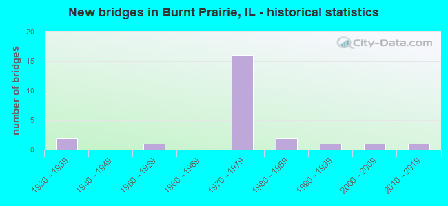
- New bridges - historical statistics
- 21930-1939
- 11950-1959
- 161970-1979
- 21980-1989
- 11990-1999
- 12000-2009
- 12010-2019


- Bridge Condition - Deck
- 5.9%Very good
- 41.2%Good
- 41.2%Satisfactory
- 5.9%Fair
- 5.9%Poor

- Bridge Condition - Superstructure
- 5.9%Very good
- 29.4%Good
- 47.1%Satisfactory
- 5.9%Fair
- 11.8%Poor

- Bridge Condition - Substructure
- 17.6%Very good
- 41.2%Good
- 29.4%Satisfactory
- 5.9%Fair
- 5.9%Serious

- Bridge Condition - Channel
- 6.3%Very good
- 56.3%Good
- 31.3%Satisfactory
- 6.3%Fair

- Bridge Condition - Culverts
- 66.7%Good
- 33.3%Fair
Find on map >> Show street view
Structure Number: 960037, Location: 4.5 MI E US-45 INT (Lat: 38.260194, Lng: -88.273211), Route carried "on" structure: County highway , Year Built: 1972, Status: Open, Structure Length: 8.35m (27.40ft), Average Daily Traffic: 200 (year 2019), Truck Traffic: 10%, Average Future Daily Traffic: 200 (year 2032), Design Load: HS 15, Features Intersected: FAI-64, Facility Carried by Structure: CH-6
Minimum Vertical Clearance: 5.18m (16.99ft), Kilometerpoint: 16.334, Lanes on structure: 2, Lanes under structure: 4, Owner: State Highway Agency, Approaching Roadway Width: 6.7m (22.0ft), Skew: 2 degrees, Material/Design: Steel continuous, Design/Construction: Stringer/Multi-beam, Number Of Spans In Main Unit: 2, Number Of Approach Spans: 2, Length of Maximum Span: 35.4m (116.1ft), Curb-To-Curb Width: 8.1m (26.6ft), Out-to-Out Width: 9.2m (30.2ft)
Condition: Deck: Good, Superstructure: Satisfactory, Substructure: Good, Operating Rating: 41.5 metric tons, Method Used To Determine Operating Rating: Load Factor (LF) rating reported by rating factor (RF) method using MS18 loading, Inventory Rating: 24.9 metric tons, Method Used To Determine Inventory Rating: Load Factor (LF) rating reported by rating factor (RF) method using MS18 loading, Structural Evaluation: Equal to present minimum criteria, Deck Geometry: Somewhat better than minimum adequacy, Underclear: Equal to present minimum criteria, Approach Roadway Alignment: Equal to present desirable criteria, Length Of Structure Improvement: 1.31m (4.30ft), Designated Inspection Frequency: Every 24 months, Inspection Date: May 2021, Bridge Improvement Cost: $170,000, Roadway Improvement Cost: $29,000, Total Project Cost: $199,000, Deck Structure Type: Concrete Cast-file-Place
Find on map >> Show street view
Structure Number: 960038, Location: 5.5 MI E US-45 INT (Lat: 38.260650, Lng: -88.261011), Route carried "on" structure: County highway , Year Built: 1974, Status: Open, Structure Length: 7.19m (23.59ft), Average Daily Traffic: 75 (year 2019), Truck Traffic: 9%, Average Future Daily Traffic: 75 (year 2032), Design Load: HS 15, Features Intersected: FAI-64, Facility Carried by Structure: FAS 2812
Minimum Vertical Clearance: 4.98m (16.34ft), Kilometerpoint: 13.937, Lanes on structure: 2, Lanes under structure: 4, Owner: State Highway Agency, Approaching Roadway Width: 4.9m (16.1ft), Material/Design: Steel continuous, Design/Construction: Stringer/Multi-beam, Number Of Spans In Main Unit: 2, Number Of Approach Spans: 2, Length of Maximum Span: 27.7m (90.9ft), Curb-To-Curb Width: 8.1m (26.6ft), Out-to-Out Width: 9.4m (30.8ft)
Condition: Deck: Good, Superstructure: Good, Substructure: Good, Operating Rating: 65.4 metric tons, Method Used To Determine Operating Rating: Load Factor (LF) rating reported by rating factor (RF) method using MS18 loading, Inventory Rating: 39.2 metric tons, Method Used To Determine Inventory Rating: Load Factor (LF) rating reported by rating factor (RF) method using MS18 loading, Structural Evaluation: Better than present minimum criteria, Deck Geometry: Equal to present minimum criteria, Underclear: Somewhat better than minimum adequacy, Approach Roadway Alignment: Equal to present desirable criteria, Designated Inspection Frequency: Every 24 months, Inspection Date: May 2021, Deck Structure Type: Concrete Cast-file-Place
Find on map >> Show street view
Structure Number: 960051, Location: 6 MI E US-45 INT (Lat: 38.259461, Lng: -88.252103), Route carried "on" structure: Interstate 64, Year Built: 1974, Status: Open, Structure Length: 2.99m (9.81ft), Average Daily Traffic: 6,050 (year 2021), Truck Traffic: 41%, Average Future Daily Traffic: 4,830 (year 2032), Design Load: HS 20+Mod, Features Intersected: POND CREEK BRANCH
Minimum Vertical Clearance: 30+ m (98+ ft), Kilometerpoint: 186.341, Lanes on structure: 2, Base Highway Network: Yes, Owner: State Highway Agency, Approaching Roadway Width: 12.2m (40.0ft), Material/Design: Concrete continuous, Design/Construction: Slab, Number Of Spans In Main Unit: 3, Length of Maximum Span: 11.0m (36.1ft), Curb-To-Curb Width: 11.7m (38.4ft), Out-to-Out Width: 12.8m (42.0ft)
Condition: Deck: Satisfactory, Superstructure: Satisfactory, Substructure: Good, Channel: Good, Operating Rating: 44.7 metric tons, Method Used To Determine Operating Rating: Load Factor (LF) rating reported by rating factor (RF) method using MS18 loading, Inventory Rating: 26.6 metric tons, Method Used To Determine Inventory Rating: Load Factor (LF) rating reported by rating factor (RF) method using MS18 loading, Structural Evaluation: Equal to present minimum criteria, Deck Geometry: Equal to present minimum criteria, Waterway Adequacy: Equal to present desirable criteria, Approach Roadway Alignment: Equal to present desirable criteria, Designated Inspection Frequency: Every 24 months, Inspection Date: June 2020, Deck Structure Type: Concrete Cast-file-Place, Wearing Surface/Protective System: Wearing Surface: Other
Find on map >> Show street view
Structure Number: 960052, Location: 6 MI E US-45 INT (Lat: 38.259294, Lng: -88.251642), Route carried "on" structure: Interstate 64, Year Built: 1974, Status: Open, Structure Length: 3.17m (10.40ft), Average Daily Traffic: 6,050 (year 2021), Truck Traffic: 41%, Average Future Daily Traffic: 4,830 (year 2032), Design Load: HS 20+Mod, Features Intersected: POND CREEK BRANCH
Minimum Vertical Clearance: 30+ m (98+ ft), Kilometerpoint: 186.389, Lanes on structure: 2, Base Highway Network: Yes, Owner: State Highway Agency, Approaching Roadway Width: 12.2m (40.0ft), Skew: 1 degrees, Material/Design: Concrete continuous, Design/Construction: Slab, Number Of Spans In Main Unit: 3, Length of Maximum Span: 11.6m (38.1ft), Curb-To-Curb Width: 11.7m (38.4ft), Out-to-Out Width: 12.8m (42.0ft)
Condition: Deck: Satisfactory, Superstructure: Satisfactory, Substructure: Good, Channel: Good, Operating Rating: 44.4 metric tons, Method Used To Determine Operating Rating: Load Factor (LF) rating reported by rating factor (RF) method using MS18 loading, Inventory Rating: 26.6 metric tons, Method Used To Determine Inventory Rating: Load Factor (LF) rating reported by rating factor (RF) method using MS18 loading, Structural Evaluation: Equal to present minimum criteria, Deck Geometry: Equal to present minimum criteria, Waterway Adequacy: Equal to present desirable criteria, Approach Roadway Alignment: Equal to present desirable criteria, Designated Inspection Frequency: Every 24 months, Inspection Date: June 2020, Deck Structure Type: Concrete Cast-file-Place, Wearing Surface/Protective System: Wearing Surface: Other
Find on map >> Show street view
Structure Number: 96006, Location: 6.1 MI E US-45 INT (Lat: 38.258869, Lng: -88.250581), Route carried "on" structure: Interstate 64, Year Built: 1974, Status: Open, Structure Length: 5.73m (18.80ft), Average Daily Traffic: 6,050 (year 2021), Truck Traffic: 41%, Average Future Daily Traffic: 4,830 (year 2032), Design Load: HS 20+Mod, Features Intersected: POND CREEK
Minimum Vertical Clearance: 30+ m (98+ ft), Kilometerpoint: 186.502, Lanes on structure: 2, Base Highway Network: Yes, Owner: State Highway Agency, Approaching Roadway Width: 12.2m (40.0ft), Skew: 5 degrees, Material/Design: Steel continuous, Design/Construction: Stringer/Multi-beam, Number Of Spans In Main Unit: 3, Length of Maximum Span: 21.3m (69.9ft), Curb-To-Curb Width: 11.7m (38.4ft), Out-to-Out Width: 13.0m (42.7ft)
Condition: Deck: Satisfactory, Superstructure: Satisfactory, Substructure: Satisfactory, Channel: Good, Operating Rating: 71.9 metric tons, Method Used To Determine Operating Rating: Load Factor (LF) rating reported by rating factor (RF) method using MS18 loading, Inventory Rating: 39.5 metric tons, Method Used To Determine Inventory Rating: Load Factor (LF) rating reported by rating factor (RF) method using MS18 loading, Structural Evaluation: Equal to present minimum criteria, Deck Geometry: Equal to present minimum criteria, Waterway Adequacy: Equal to present desirable criteria, Approach Roadway Alignment: Equal to present desirable criteria, Designated Inspection Frequency: Every 24 months, Inspection Date: June 2020, Deck Structure Type: Concrete Cast-file-Place, Wearing Surface/Protective System: Wearing Surface: Other
Find on map >> Show street view
Structure Number: 963353, Location: 4.5 MI S GOLDEN GATE (Lat: 38.293003, Lng: -88.235850), Route carried "on" structure: County highway , Year Built: 1984, Status: Open, Structure Length: 0.76m (2.49ft), Average Daily Traffic: 50 (year 2017), Truck Traffic: 8%, Average Future Daily Traffic: 53 (year 2032), Features Intersected: POND CREEK, Facility Carried by Structure: TR-627
Minimum Vertical Clearance: 30+ m (98+ ft), Kilometerpoint: 0.901, Lanes on structure: 2, Owner: Town or Township Highway Agency, Approaching Roadway Width: 4.9m (16.1ft), Material/Design: Steel, Design/Construction: Stringer/Multi-beam, Number Of Spans In Main Unit: 1, Length of Maximum Span: 7.3m (24.0ft), Curb-To-Curb Width: 4.9m (16.1ft), Out-to-Out Width: 4.9m (16.1ft)
Condition: Deck: Good, Superstructure: Poor, Substructure: Fair, Channel: Satisfactory, Operating Rating: 40.2 metric tons, Method Used To Determine Operating Rating: Load Factor (LF) rating reported by rating factor (RF) method using MS18 loading, Inventory Rating: 24.0 metric tons, Method Used To Determine Inventory Rating: Load Factor (LF) rating reported by rating factor (RF) method using MS18 loading, Structural Evaluation: Meets minimum limits, Deck Geometry: High priority of corrective action, Waterway Adequacy: High priority of corrective action, Approach Roadway Alignment: Equal to present minimum criteria, Designated Inspection Frequency: Every 24 months, Other Special Inspection Frequency: Every 12 months, Inspection Date: January 2022, Other Special Inspection Date: January 2022, Deck Structure Type: Concrete Cast-file-Place
Find on map >> Show street view
Structure Number: 963388, Location: 2 MI NE BURNT PRAIRI (Lat: 38.282181, Lng: -88.235842), Route carried "on" structure: County highway , Year Built: 1990, Status: Open, Structure Length: 2.79m (9.15ft), Average Daily Traffic: 50 (year 2017), Truck Traffic: 8%, Average Future Daily Traffic: 53 (year 2032), Design Load: HS 20, Features Intersected: POND CREEK, Facility Carried by Structure: TR 647
Minimum Vertical Clearance: 30+ m (98+ ft), Kilometerpoint: 0.531, Lanes on structure: 2, Owner: Town or Township Highway Agency, Approaching Roadway Width: 4.9m (16.1ft), Material/Design: Prestressed concrete, Design/Construction: Box Beam or Girders - Multiple, Number Of Spans In Main Unit: 3, Length of Maximum Span: 12.2m (40.0ft), Curb-To-Curb Width: 7.3m (24.0ft), Out-to-Out Width: 7.3m (24.0ft)
Condition: Deck: Good, Superstructure: Good, Substructure: Good, Channel: Good, Operating Rating: 44.4 metric tons, Method Used To Determine Operating Rating: Assigned rating based on Load Factor Design (LFD) reported by rating factor (RF) using MS18 loading, Inventory Rating: 32.4 metric tons, Method Used To Determine Inventory Rating: Assigned rating based on Load Factor Design (LFD) reported by rating factor (RF) using MS18 loading, Structural Evaluation: Better than present minimum criteria, Deck Geometry: Equal to present minimum criteria, Waterway Adequacy: Somewhat better than minimum adequacy, Approach Roadway Alignment: Equal to present desirable criteria, Designated Inspection Frequency: Every 48 months, Inspection Date: Febuary 2019, Deck Structure Type: Concrete Precast Panels
Find on map >> Show street view
Structure Number: 96342, Location: 6 MI SE BARNHILL (Lat: 38.275214, Lng: -88.260667), Route carried "on" structure: County highway , Year Built: 2000, Status: Open, Structure Length: 1.96m (6.43ft), Average Daily Traffic: 75 (year 2017), Truck Traffic: 8%, Average Future Daily Traffic: 53 (year 2032), Design Load: HS 20, Features Intersected: STREAM, Facility Carried by Structure: FAS 2812 (TR 536)
Minimum Vertical Clearance: 30+ m (98+ ft), Kilometerpoint: 12.359, Lanes on structure: 2, Owner: Town or Township Highway Agency, Approaching Roadway Width: 5.5m (18.0ft), Skew: 2 degrees, Material/Design: Prestressed concrete, Design/Construction: Box Beam or Girders - Multiple, Number Of Spans In Main Unit: 1, Length of Maximum Span: 18.3m (60.0ft), Curb-To-Curb Width: 7.3m (24.0ft), Out-to-Out Width: 7.3m (24.0ft)
Condition: Deck: Good, Superstructure: Good, Substructure: Very good, Channel: Good, Operating Rating: 44.1 metric tons, Method Used To Determine Operating Rating: Assigned rating based on Load Factor Design (LFD) reported by rating factor (RF) using MS18 loading, Inventory Rating: 32.4 metric tons, Method Used To Determine Inventory Rating: Assigned rating based on Load Factor Design (LFD) reported by rating factor (RF) using MS18 loading, Structural Evaluation: Better than present minimum criteria, Deck Geometry: Equal to present minimum criteria, Waterway Adequacy: Equal to present desirable criteria, Approach Roadway Alignment: Equal to present desirable criteria, Designated Inspection Frequency: Every 48 months, Inspection Date: Febuary 2018, Deck Structure Type: Concrete Precast Panels
Find on map >> Show street view
Structure Number: 97004, Location: .25 MI E WAYNE CO LN (Lat: 38.254519, Lng: -88.242306), Route carried "on" structure: Interstate 64, Year Built: 1971, Status: Open, Structure Length: 4.33m (14.21ft), Average Daily Traffic: 6,050 (year 2021), Truck Traffic: 41%, Average Future Daily Traffic: 4,609 (year 2032), Design Load: HS 20+Mod, Features Intersected: POND CREEK
Minimum Vertical Clearance: 30+ m (98+ ft), Kilometerpoint: 187.387, Lanes on structure: 2, Base Highway Network: Yes, Owner: State Highway Agency, Approaching Roadway Width: 12.2m (40.0ft), Skew: 2 degrees, Material/Design: Steel continuous, Design/Construction: Stringer/Multi-beam, Number Of Spans In Main Unit: 3, Length of Maximum Span: 15.2m (49.9ft), Curb-To-Curb Width: 11.7m (38.4ft), Out-to-Out Width: 12.9m (42.3ft)
Condition: Deck: Satisfactory, Superstructure: Satisfactory, Substructure: Good, Channel: Good, Operating Rating: 61.2 metric tons, Method Used To Determine Operating Rating: Load Factor (LF) rating reported by rating factor (RF) method using MS18 loading, Inventory Rating: 32.7 metric tons, Method Used To Determine Inventory Rating: Load Factor (LF) rating reported by rating factor (RF) method using MS18 loading, Structural Evaluation: Equal to present minimum criteria, Deck Geometry: Equal to present minimum criteria, Waterway Adequacy: Equal to present desirable criteria, Approach Roadway Alignment: Equal to present desirable criteria, Designated Inspection Frequency: Every 24 months, Inspection Date: August 2020, Deck Structure Type: Concrete Cast-file-Place, Wearing Surface/Protective System: Wearing Surface: Other
Find on map >> Show street view
Structure Number: 970042, Location: 11.5 MI W ILL-1 (Lat: 38.245792, Lng: -88.210397), Route carried "on" structure: Interstate 64, Year Built: 1972, Status: Open, Structure Length: 1.04m (3.41ft), Average Daily Traffic: 6,050 (year 2021), Truck Traffic: 41%, Average Future Daily Traffic: 4,709 (year 2032), Design Load: HS 20+Mod, Features Intersected: TRIB RANDOLPH DITCH
Minimum Vertical Clearance: 30+ m (98+ ft), Kilometerpoint: 190.300, Lanes on structure: 2, Base Highway Network: Yes, Owner: State Highway Agency, Approaching Roadway Width: 12.2m (40.0ft), Material/Design: Concrete, Design/Construction: Slab, Number Of Spans In Main Unit: 1, Length of Maximum Span: 10.4m (34.1ft), Curb-To-Curb Width: 12.1m (39.7ft), Out-to-Out Width: 12.9m (42.3ft)
Condition: Deck: Satisfactory, Superstructure: Satisfactory, Substructure: Satisfactory, Channel: Satisfactory, Operating Rating: 62.9 metric tons, Method Used To Determine Operating Rating: Load Factor (LF) rating reported by rating factor (RF) method using MS18 loading, Inventory Rating: 37.6 metric tons, Method Used To Determine Inventory Rating: Load Factor (LF) rating reported by rating factor (RF) method using MS18 loading, Structural Evaluation: Equal to present minimum criteria, Deck Geometry: Equal to present minimum criteria, Waterway Adequacy: Equal to present desirable criteria, Approach Roadway Alignment: Equal to present desirable criteria, Designated Inspection Frequency: Every 24 months, Inspection Date: August 2020, Deck Structure Type: Concrete Cast-file-Place, Wearing Surface/Protective System: Wearing Surface: Other
Find on map >> Show street view
Structure Number: 970043, Location: 11.5 MI W ILL-1 (Lat: 38.245828, Lng: -88.210569), Route carried "on" structure: Interstate 64, Year Built: 1972, Status: Open, Structure Length: 1.04m (3.41ft), Average Daily Traffic: 6,050 (year 2021), Truck Traffic: 41%, Average Future Daily Traffic: 4,709 (year 2032), Design Load: HS 20+Mod, Features Intersected: TRIB RANDOLPH DITCH
Minimum Vertical Clearance: 30+ m (98+ ft), Kilometerpoint: 190.284, Lanes on structure: 2, Base Highway Network: Yes, Owner: State Highway Agency, Approaching Roadway Width: 12.2m (40.0ft), Material/Design: Concrete, Design/Construction: Slab, Number Of Spans In Main Unit: 1, Length of Maximum Span: 10.4m (34.1ft), Curb-To-Curb Width: 12.1m (39.7ft), Out-to-Out Width: 13.0m (42.7ft)
Condition: Deck: Satisfactory, Superstructure: Satisfactory, Substructure: Satisfactory, Channel: Satisfactory, Operating Rating: 62.9 metric tons, Method Used To Determine Operating Rating: Load Factor (LF) rating reported by rating factor (RF) method using MS18 loading, Inventory Rating: 37.6 metric tons, Method Used To Determine Inventory Rating: Load Factor (LF) rating reported by rating factor (RF) method using MS18 loading, Structural Evaluation: Equal to present minimum criteria, Deck Geometry: Equal to present minimum criteria, Waterway Adequacy: Equal to present desirable criteria, Approach Roadway Alignment: Equal to present desirable criteria, Designated Inspection Frequency: Every 24 months, Inspection Date: August 2020, Deck Structure Type: Concrete Cast-file-Place, Wearing Surface/Protective System: Wearing Surface: Other
Find on map >> Show street view
Structure Number: 970044, Location: BURNT PRAIRIE INT (Lat: 38.250300, Lng: -88.230011), Route carried "on" structure: County highway , Year Built: 1972, Status: Open, Structure Length: 7.77m (25.49ft), Average Daily Traffic: 400 (year 2019), Truck Traffic: 28%, Average Future Daily Traffic: 1,052 (year 2032), Design Load: HS 15, Features Intersected: FAI-64, Facility Carried by Structure: FAS-815 (CH-20)
Minimum Vertical Clearance: 30+ m (98+ ft), Kilometerpoint: 10.396, Lanes on structure: 2, Lanes under structure: 4, Owner: State Highway Agency, Approaching Roadway Width: 9.1m (29.9ft), Skew: 2 degrees, Material/Design: Steel continuous, Design/Construction: Stringer/Multi-beam, Number Of Spans In Main Unit: 2, Number Of Approach Spans: 2, Length of Maximum Span: 32.9m (107.9ft), Curb-To-Curb Width: 8.7m (28.5ft), Out-to-Out Width: 9.8m (32.2ft)
Condition: Deck: Satisfactory, Superstructure: Satisfactory, Substructure: Satisfactory, Operating Rating: 60.9 metric tons, Method Used To Determine Operating Rating: Load Factor (LF) rating reported by rating factor (RF) method using MS18 loading, Inventory Rating: 36.6 metric tons, Method Used To Determine Inventory Rating: Load Factor (LF) rating reported by rating factor (RF) method using MS18 loading, Structural Evaluation: Equal to present minimum criteria, Deck Geometry: Equal to present minimum criteria, Underclear: Somewhat better than minimum adequacy, Approach Roadway Alignment: Equal to present desirable criteria, Designated Inspection Frequency: Every 24 months, Inspection Date: October 2020, Deck Structure Type: Concrete Cast-file-Place, Wearing Surface/Protective System: Wearing Surface: Bituminous, Membrane: Built-up
Find on map >> Show street view
Structure Number: 970045, Location: 10 MI W ILL-1 (Lat: 38.241900, Lng: -88.197139), Route carried "on" structure: County highway , Year Built: 1975, Status: Open, Structure Length: 7.65m (25.10ft), Average Daily Traffic: 25 (year 2019), Truck Traffic: 56%, Average Future Daily Traffic: 75 (year 2032), Design Load: HS 15, Features Intersected: FAI-64, Facility Carried by Structure: TR-214
Minimum Vertical Clearance: 30+ m (98+ ft), Kilometerpoint: 0.772, Lanes on structure: 2, Lanes under structure: 4, Owner: State Highway Agency, Approaching Roadway Width: 6.1m (20.0ft), Skew: 2 degrees, Material/Design: Steel continuous, Design/Construction: Stringer/Multi-beam, Number Of Spans In Main Unit: 2, Number Of Approach Spans: 2, Length of Maximum Span: 32.3m (106.0ft), Curb-To-Curb Width: 8.1m (26.6ft), Out-to-Out Width: 9.2m (30.2ft)
Condition: Deck: Good, Superstructure: Good, Substructure: Good, Operating Rating: 50.5 metric tons, Method Used To Determine Operating Rating: Load Factor (LF) rating reported by rating factor (RF) method using MS18 loading, Inventory Rating: 30.5 metric tons, Method Used To Determine Inventory Rating: Load Factor (LF) rating reported by rating factor (RF) method using MS18 loading, Structural Evaluation: Better than present minimum criteria, Deck Geometry: Equal to present minimum criteria, Underclear: Somewhat better than minimum adequacy, Approach Roadway Alignment: Equal to present desirable criteria, Designated Inspection Frequency: Every 24 months, Inspection Date: October 2020, Deck Structure Type: Concrete Cast-file-Place
Find on map >> Show street view
Structure Number: 972004, Location: 0.1MI E WAYNE CO LN (Lat: 38.255481, Lng: -88.244250), Route carried "on" structure: Interstate 64, Year Built: 1975, Status: Open, Structure Length: 1.91m (6.27ft), Average Daily Traffic: 6,050 (year 2021), Truck Traffic: 41%, Average Future Daily Traffic: 4,609 (year 2032), Design Load: HS 20+Mod, Features Intersected: POND CREEK OVFL
Minimum Vertical Clearance: 30+ m (98+ ft), Kilometerpoint: 187.194, Lanes on structure: 2, Base Highway Network: Yes, Owner: State Highway Agency, Approaching Roadway Width: 11.6m (38.1ft), Skew: 6 degrees, Material/Design: Concrete continuous, Design/Construction: Culvert, Number Of Spans In Main Unit: 3, Length of Maximum Span: 7.1m (23.3ft)
Condition: Channel: Good, Culverts: Fair, Operating Rating: 77.8 metric tons, Method Used To Determine Operating Rating: Load Factor (LF) rating reported by rating factor (RF) method using MS18 loading, Inventory Rating: 46.3 metric tons, Method Used To Determine Inventory Rating: Load Factor (LF) rating reported by rating factor (RF) method using MS18 loading, Structural Evaluation: Somewhat better than minimum adequacy, Waterway Adequacy: Equal to present desirable criteria, Approach Roadway Alignment: Equal to present desirable criteria, Designated Inspection Frequency: Every 24 months, Inspection Date: January 2022
Find on map >> Show street view
Structure Number: 973086, Location: 2.5 MI E BURNT PRAIR (Lat: 38.249186, Lng: -88.206092), Route carried "on" structure: County highway , Year Built: 1956, Status: Posted for load, Structure Length: 0.91m (2.99ft), Average Daily Traffic: 10 (year 2019), Truck Traffic: 10%, Average Future Daily Traffic: 9 (year 2032), Design Load: H 15, Features Intersected: DRAINAGE DITCH, Facility Carried by Structure: TR-206
Minimum Vertical Clearance: 30+ m (98+ ft), Kilometerpoint: 0.805, Lanes on structure: 2, Owner: Town or Township Highway Agency, Approaching Roadway Width: 6.7m (22.0ft), Material/Design: Prestressed concrete, Design/Construction: Box Beam or Girders - Multiple, Number Of Spans In Main Unit: 1, Length of Maximum Span: 8.5m (27.9ft), Curb-To-Curb Width: 5.9m (19.4ft), Out-to-Out Width: 6.4m (21.0ft)
Condition: Deck: Poor, Superstructure: Poor, Substructure: Serious, Channel: Fair, Operating Rating: 32.4 metric tons, Method Used To Determine Operating Rating: Load Factor (LF) rating reported by rating factor (RF) method using MS18 loading, Structural Evaluation: High priority of replacement, Deck Geometry: Meets minimum limits, Waterway Adequacy: Equal to present minimum criteria, Approach Roadway Alignment: Meets minimum limits, Bridge Posting: Required (Relationship of Operating Rating to Maximum Legal Load: > 39.9% below), Length Of Structure Improvement: 0.91m (2.99ft), Designated Inspection Frequency: Every 24 months, Other Special Inspection Frequency: Every 6 months, Inspection Date: January 2021, Other Special Inspection Date: July 2021, Bridge Improvement Cost: $150,000, Roadway Improvement Cost: $40,000, Total Project Cost: $190,000, Deck Structure Type: Concrete Precast Panels
Find on map >> Show street view
Structure Number: 973151, Location: 3 MI E BURNT PRAIRIE (Lat: 38.246081, Lng: -88.197033), Route carried "on" structure: County highway , Year Built: 1977, Status: Open, Structure Length: 1.83m (6.00ft), Average Daily Traffic: 25 (year 2019), Truck Traffic: 56%, Average Future Daily Traffic: 75 (year 2032), Design Load: HS 20, Features Intersected: DRAINAGE DITCH, Facility Carried by Structure: TR-214
Minimum Vertical Clearance: 30+ m (98+ ft), Kilometerpoint: 0.338, Lanes on structure: 2, Owner: Town or Township Highway Agency, Approaching Roadway Width: 7.3m (24.0ft), Skew: 4 degrees, Material/Design: Concrete, Design/Construction: Channel Beam, Number Of Spans In Main Unit: 3, Length of Maximum Span: 8.8m (28.9ft), Curb-To-Curb Width: 6.7m (22.0ft), Out-to-Out Width: 6.9m (22.6ft)
Condition: Deck: Good, Superstructure: Good, Substructure: Satisfactory, Channel: Good, Operating Rating: 44.1 metric tons, Method Used To Determine Operating Rating: Assigned rating based on Load Factor Design (LFD) reported by rating factor (RF) using MS18 loading, Inventory Rating: 32.4 metric tons, Method Used To Determine Inventory Rating: Assigned rating based on Load Factor Design (LFD) reported by rating factor (RF) using MS18 loading, Structural Evaluation: Equal to present minimum criteria, Deck Geometry: Somewhat better than minimum adequacy, Waterway Adequacy: Equal to present desirable criteria, Approach Roadway Alignment: Equal to present desirable criteria, Designated Inspection Frequency: Every 24 months, Inspection Date: Febuary 2022, Deck Structure Type: Concrete Precast Panels
Find on map >> Show street view
Structure Number: 973181, Location: 2 MI SW BURNT PRAIRI (Lat: 38.224222, Lng: -88.273406), Route carried "on" structure: County highway , Year Built: 1984, Status: Open, Structure Length: 1.58m (5.18ft), Average Daily Traffic: 10 (year 2019), Truck Traffic: 10%, Average Future Daily Traffic: 251 (year 2032), Design Load: HS 20, Features Intersected: PRAIRE CREEK, Facility Carried by Structure: TR-19
Minimum Vertical Clearance: 30+ m (98+ ft), Kilometerpoint: 4.780, Lanes on structure: 2, Owner: Town or Township Highway Agency, Approaching Roadway Width: 6.7m (22.0ft), Material/Design: Prestressed concrete, Design/Construction: Box Beam or Girders - Multiple, Number Of Spans In Main Unit: 1, Length of Maximum Span: 14.6m (47.9ft), Curb-To-Curb Width: 7.3m (24.0ft), Out-to-Out Width: 7.3m (24.0ft)
Condition: Deck: Fair, Superstructure: Fair, Substructure: Very good, Channel: Good, Operating Rating: 44.4 metric tons, Method Used To Determine Operating Rating: Assigned rating based on Load Factor Design (LFD) reported by rating factor (RF) using MS18 loading, Inventory Rating: 32.4 metric tons, Method Used To Determine Inventory Rating: Assigned rating based on Load Factor Design (LFD) reported by rating factor (RF) using MS18 loading, Structural Evaluation: Somewhat better than minimum adequacy, Deck Geometry: Equal to present minimum criteria, Waterway Adequacy: Equal to present desirable criteria, Approach Roadway Alignment: Equal to present minimum criteria, Designated Inspection Frequency: Every 24 months, Inspection Date: March 2021, Deck Structure Type: Concrete Precast Panels
Find on map >> Show street view
Structure Number: 973281, Location: 4.25 MI NE SPRINGRTN (Lat: 38.211158, Lng: -88.284689), Route carried "on" structure: County highway , Year Built: 2015, Status: Open, Structure Length: 2.17m (7.12ft), Average Daily Traffic: 50 (year 2019), Truck Traffic: 20%, Average Future Daily Traffic: 25 (year 2032), Design Load: HS 25 or greater, Features Intersected: PRAIRIE CREEK, Facility Carried by Structure: 475 E
Minimum Vertical Clearance: 30+ m (98+ ft), Kilometerpoint: 4.747, Lanes on structure: 2, Owner: Town or Township Highway Agency, Approaching Roadway Width: 5.5m (18.0ft), Material/Design: Prestressed concrete, Design/Construction: Box Beam or Girders - Multiple, Number Of Spans In Main Unit: 1, Length of Maximum Span: 21.0m (68.9ft), Curb-To-Curb Width: 7.3m (24.0ft), Out-to-Out Width: 7.3m (24.0ft)
Condition: Deck: Very good, Superstructure: Very good, Substructure: Very good, Channel: Very good, Operating Rating: 42.1 metric tons, Method Used To Determine Operating Rating: Assigned ratings based on Load and Resistance Factor Design (LRFD) reported by rating factor (RF) using HL93 loadings, Inventory Rating: 32.4 metric tons, Method Used To Determine Inventory Rating: Assigned ratings based on Load and Resistance Factor Design (LRFD) reported by rating factor (RF) using HL93 loadings, Structural Evaluation: Equal to present desirable criteria, Deck Geometry: Equal to present minimum criteria, Waterway Adequacy: Equal to present desirable criteria, Approach Roadway Alignment: Equal to present desirable criteria, Designated Inspection Frequency: Every 48 months, Inspection Date: March 2018, Deck Structure Type: Concrete Precast Panels
Find on map >> Show street view
Structure Number: 975001, Location: 2 MI E BURNT PRAIRIE (Lat: 38.249400, Lng: -88.214861), Route carried "on" structure: County highway , Year Built: 1937, Status: Open, Structure Length: 1.31m (4.30ft), Average Daily Traffic: 100 (year 2019), Truck Traffic: 26%, Average Future Daily Traffic: 125 (year 2032), Design Load: HS 15, Features Intersected: DRAINAGE DITCH, Facility Carried by Structure: FAS-815
Minimum Vertical Clearance: 30+ m (98+ ft), Kilometerpoint: 11.796, Lanes on structure: 2, Owner: County Highway Agency, Approaching Roadway Width: 8.8m (28.9ft), Skew: 4 degrees, Material/Design: Concrete, Design/Construction: Culvert, Number Of Spans In Main Unit: 3, Length of Maximum Span: 4.0m (13.1ft), Curb-To-Curb Width: 9.2m (30.2ft), Out-to-Out Width: 9.5m (31.2ft)
Condition: Channel: Satisfactory, Culverts: Good, Operating Rating: 40.5 metric tons, Method Used To Determine Operating Rating: Field evaluation and documented engineering judgment, Inventory Rating: 24.3 metric tons, Method Used To Determine Inventory Rating: Field evaluation and documented engineering judgment, Structural Evaluation: Equal to present minimum criteria, Deck Geometry: Better than present minimum criteria, Waterway Adequacy: Somewhat better than minimum adequacy, Approach Roadway Alignment: Better than present minimum criteria, Designated Inspection Frequency: Every 24 months, Inspection Date: January 2020
Find on map >> Show street view
Structure Number: 975002, Location: 2.75 MI E BURNT PRAI (Lat: 38.249331, Lng: -88.201322), Route carried "on" structure: County highway , Year Built: 1937, Status: Open, Structure Length: 1.07m (3.51ft), Average Daily Traffic: 100 (year 2019), Truck Traffic: 26%, Average Future Daily Traffic: 150 (year 2032), Design Load: HS 15, Features Intersected: DRAINAGE DITCH, Facility Carried by Structure: FAS-815
Minimum Vertical Clearance: 30+ m (98+ ft), Kilometerpoint: 12.987, Lanes on structure: 2, Owner: County Highway Agency, Approaching Roadway Width: 7.3m (24.0ft), Skew: 4 degrees, Material/Design: Concrete, Design/Construction: Culvert, Number Of Spans In Main Unit: 2, Length of Maximum Span: 4.6m (15.1ft), Curb-To-Curb Width: 9.2m (30.2ft), Out-to-Out Width: 9.4m (30.8ft)
Condition: Channel: Satisfactory, Culverts: Good, Operating Rating: 40.5 metric tons, Method Used To Determine Operating Rating: Field evaluation and documented engineering judgment, Inventory Rating: 24.3 metric tons, Method Used To Determine Inventory Rating: Field evaluation and documented engineering judgment, Structural Evaluation: Equal to present minimum criteria, Deck Geometry: Better than present minimum criteria, Waterway Adequacy: Somewhat better than minimum adequacy, Approach Roadway Alignment: Equal to present desirable criteria, Designated Inspection Frequency: Every 24 months, Inspection Date: Febuary 2022, Wearing Surface/Protective System: Wearing Surface: Gravel
Find on map >> Show street view
Structure Number: 960037, Location: 4.5 MI E US-45 INT (Lat: 38.260069, Lng: -88.273111), Route carried "under" structure: Interstate 64, Year Built: 1972, Structure Length: 0. m, Average Daily Traffic: 12,100 (year 2021), Truck Traffic: 41%, Features Intersected: FAI-64, Facility Carried by Structure: CH-6
Minimum Vertical Clearance: 5.21m (17.09ft), Kilometerpoint: 184.410, Lanes on structure: 2, Lanes under structure: 4, Material/Design: Steel continuous, Design/Construction: Stringer/Multi-beam, Length of Maximum Span: 35.4m (116.1ft)
Find on map >> Show street view
Structure Number: 960038, Location: 5.5 MI E US-45 INT (Lat: 38.260650, Lng: -88.261011), Route carried "under" structure: Interstate 64, Year Built: 1974, Structure Length: 0. m, Average Daily Traffic: 12,100 (year 2021), Truck Traffic: 41%, Features Intersected: FAI-64, Facility Carried by Structure: FAS 2812
Minimum Vertical Clearance: 5.03m (16.50ft), Kilometerpoint: 185.472, Lanes on structure: 2, Lanes under structure: 4, Material/Design: Steel continuous, Design/Construction: Stringer/Multi-beam, Length of Maximum Span: 27.7m (90.9ft)
Find on map >> Show street view
Structure Number: 970044, Location: BURNT PRAIRIE INT (Lat: 38.250300, Lng: -88.230011), Route carried "under" structure: Interstate 64, Year Built: 1972, Structure Length: 0. m, Average Daily Traffic: 12,100 (year 2021), Truck Traffic: 41%, Features Intersected: FAI-64, Facility Carried by Structure: FAS-815 (CH-20)
Minimum Vertical Clearance: 5.69m (18.67ft), Kilometerpoint: 188.513, Lanes on structure: 2, Lanes under structure: 4, Material/Design: Steel continuous, Design/Construction: Stringer/Multi-beam, Length of Maximum Span: 32.9m (107.9ft)
Find on map >> Show street view
Structure Number: 970045, Location: 10 MI W ILL-1 (Lat: 38.241900, Lng: -88.197139), Route carried "under" structure: Interstate 64, Year Built: 1975, Structure Length: 0. m, Average Daily Traffic: 12,100 (year 2021), Truck Traffic: 41%, Features Intersected: FAI-64, Facility Carried by Structure: TR-214
Minimum Vertical Clearance: 5.03m (16.50ft), Kilometerpoint: 191.571, Lanes on structure: 2, Lanes under structure: 4, Material/Design: Steel continuous, Design/Construction: Stringer/Multi-beam, Length of Maximum Span: 32.3m (106.0ft)