Bridge Statistics for Burton, Michigan (MI)
Condition, Traffic, Stress, Structural Evaluation, Project Costs
- National Bridge Inventory (NBI) Statistics
- 38Number of bridges
- 259ft / 78.9mTotal length
- $1,241,000Total costs
- 791,353Total average daily traffic
- 50,211Total average daily truck traffic
- National Bridge Inventory (NBI) Registered Bridges for Burton
- No street view available for this location
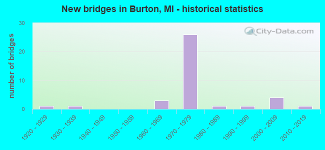
- New bridges - historical statistics
- 11920-1929
- 11930-1939
- 31960-1969
- 261970-1979
- 11980-1989
- 11990-1999
- 42000-2009
- 12010-2019
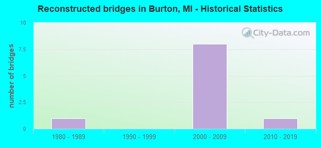
- Reconstructed bridges - Historical Statistics
- 11980-1989
- 01990-1999
- 82000-2009
- 12010-2019
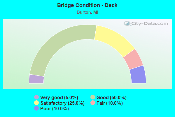
- Bridge Condition - Deck
- 5.0%Very good
- 50.0%Good
- 25.0%Satisfactory
- 10.0%Fair
- 10.0%Poor
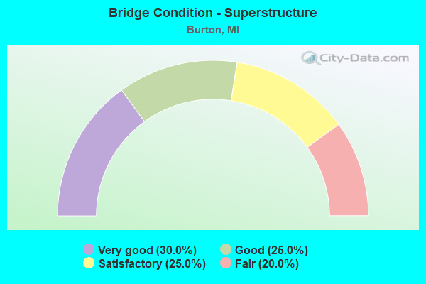
- Bridge Condition - Superstructure
- 30.0%Very good
- 25.0%Good
- 25.0%Satisfactory
- 20.0%Fair
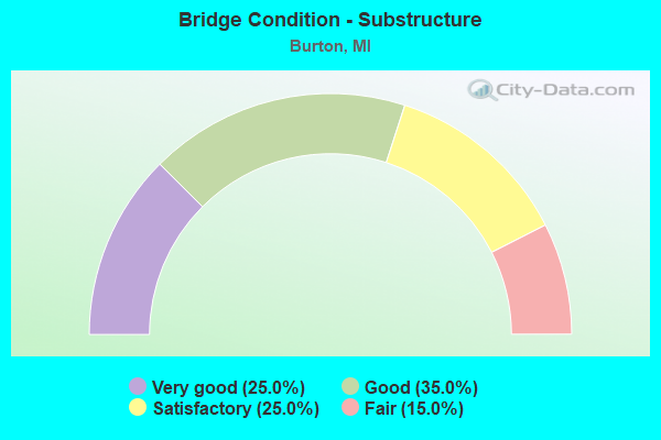
- Bridge Condition - Substructure
- 25.0%Very good
- 35.0%Good
- 25.0%Satisfactory
- 15.0%Fair
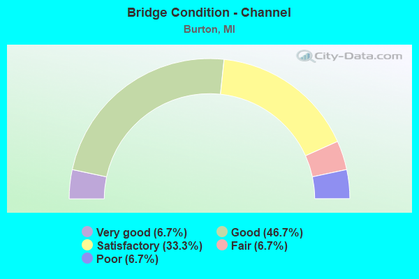
- Bridge Condition - Channel
- 6.7%Very good
- 46.7%Good
- 33.3%Satisfactory
- 6.7%Fair
- 6.7%Poor
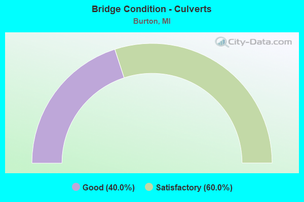
- Bridge Condition - Culverts
- 40.0%Good
- 60.0%Satisfactory
Find on map >> Show street view
Structure Number: 2576, Location: 2.6 MI W OF M-15 (Lat: 43.016322, Lng: -83.568536), Route carried "on" structure: Interstate 69, Year Built: 1970, Status: Open, Structure Length: 2.54m (8.33ft), Average Daily Traffic: 28,913 (year 2007), Truck Traffic: 10%, Average Future Daily Traffic: 76,000 (year 2026), Design Load: HS 20, Features Intersected: KEARSLEY CR
Minimum Vertical Clearance: 30.48m (100.00ft), Kilometerpoint: 31.135, Lanes on structure: 3, Base Highway Network: Yes (Inventory Route: 149, Subroute: 6), Owner: State Highway Agency, Approaching Roadway Width: 17.3m (56.8ft), Skew: 1 degrees, Material/Design: Steel, Design/Construction: Stringer/Multi-beam, Number Of Spans In Main Unit: 1, Length of Maximum Span: 25.3m (83.0ft), Curb or Sidewalk Widths: Left: 0.6m (2.0ft), Right: 0.6m (2.0ft), Curb-To-Curb Width: 15.6m (51.2ft), Out-to-Out Width: 16.8m (55.1ft)
Condition: Deck: Good, Superstructure: Satisfactory, Substructure: Good, Channel: Good, Operating Rating: 69.3 metric tons, Method Used To Determine Operating Rating: Load Factor (LF) rating reported by rating factor (RF) method using MS18 loading, Inventory Rating: 41.5 metric tons, Method Used To Determine Inventory Rating: Load Factor (LF) rating reported by rating factor (RF) method using MS18 loading, Structural Evaluation: Equal to present minimum criteria, Deck Geometry: Somewhat better than minimum adequacy, Waterway Adequacy: Equal to present desirable criteria, Approach Roadway Alignment: Equal to present desirable criteria, Designated Inspection Frequency: Every 24 months, Inspection Date: August 2020, Deck Structure Type: Concrete Cast-file-Place, Wearing Surface/Protective System: Wearing Surface: Monolithic Concrete
Find on map >> Show street view
Structure Number: 2591, Location: 1.0 MI E OF FLINT (Lat: 43.017619, Lng: -83.615103), Route carried "on" structure: Interstate 69, Year Built: 1971, Year Reconstructed: 2000, Status: Open, Structure Length: 5.31m (17.42ft), Average Daily Traffic: 33,948 (year 2007), Truck Traffic: 10%, Average Future Daily Traffic: 77,100 (year 2026), Design Load: HS 20, Features Intersected: GENESEE RD
Minimum Vertical Clearance: 30.48m (100.00ft), Kilometerpoint: 27.234, Lanes on structure: 3, Lanes under structure: 2, Base Highway Network: Yes (Inventory Route: 149, Subroute: 5), Owner: State Highway Agency, Approaching Roadway Width: 17.6m (57.7ft), Skew: 2 degrees, Material/Design: Steel, Design/Construction: Stringer/Multi-beam, Number Of Spans In Main Unit: 3, Length of Maximum Span: 29.4m (96.5ft), Curb-To-Curb Width: 15.6m (51.2ft), Out-to-Out Width: 16.8m (55.1ft)
Condition: Deck: Fair, Superstructure: Fair, Substructure: Fair, Operating Rating: 91.4 metric tons, Method Used To Determine Operating Rating: Load Factor (LF) rating reported by rating factor (RF) method using MS18 loading, Inventory Rating: 53.1 metric tons, Method Used To Determine Inventory Rating: Load Factor (LF) rating reported by rating factor (RF) method using MS18 loading, Structural Evaluation: Somewhat better than minimum adequacy, Deck Geometry: Somewhat better than minimum adequacy, Underclear: Equal to present minimum criteria, Approach Roadway Alignment: Equal to present desirable criteria, Designated Inspection Frequency: Every 24 months, Inspection Date: August 2020, Deck Structure Type: Concrete Cast-file-Place, Wearing Surface/Protective System: Wearing Surface: Latex Concrete
Find on map >> Show street view
Structure Number: 2592, Location: 2.0 MI E OF FLINT (Lat: 43.019433, Lng: -83.595342), Route carried "on" structure: County highway 2002, Year Built: 1971, Status: Open, Structure Length: 7.80m (25.59ft), Average Daily Traffic: 11,800 (year 1988), Average Future Daily Traffic: 13,570 (year 2008), Design Load: H 20, Features Intersected: I-69, Facility Carried by Structure: BELSAY RD
Minimum Vertical Clearance: 30.48m (100.00ft), Kilometerpoint: 6.476, Lanes on structure: 4, Lanes under structure: 8, Owner: State Highway Agency, Approaching Roadway Width: 23.4m (76.8ft), Skew: 20 degrees, Material/Design: Steel continuous, Design/Construction: Stringer/Multi-beam, Number Of Spans In Main Unit: 2, Length of Maximum Span: 38.3m (125.7ft), Curb-To-Curb Width: 20.7m (67.9ft), Out-to-Out Width: 24.4m (80.1ft)
Condition: Deck: Satisfactory, Superstructure: Fair, Substructure: Satisfactory, Operating Rating: 65.4 metric tons, Method Used To Determine Operating Rating: Load Factor (LF) rating reported by rating factor (RF) method using MS18 loading, Inventory Rating: 39.2 metric tons, Method Used To Determine Inventory Rating: Load Factor (LF) rating reported by rating factor (RF) method using MS18 loading, Structural Evaluation: Somewhat better than minimum adequacy, Deck Geometry: Superior to present desirable criteria, Underclear: Somewhat better than minimum adequacy, Approach Roadway Alignment: Equal to present desirable criteria, Length Of Structure Improvement: 7.80m (25.59ft), Designated Inspection Frequency: Every 24 months, Inspection Date: August 2020, Bridge Improvement Cost: $330,000, Roadway Improvement Cost: $17,000, Total Project Cost: $197,000, Deck Structure Type: Concrete Cast-file-Place, Wearing Surface/Protective System: Wearing Surface: Epoxy Overlay
Find on map >> Show street view
Structure Number: 2593, Location: 4.0 MI E OF FLINT (Lat: 43.016806, Lng: -83.555644), Route carried "on" structure: Interstate 69, Year Built: 1970, Year Reconstructed: 2013, Status: Open, Structure Length: 5.35m (17.55ft), Average Daily Traffic: 23,125 (year 2013), Truck Traffic: 12%, Average Future Daily Traffic: 24,576 (year 2033), Design Load: HS 20, Features Intersected: IRISH RD
Minimum Vertical Clearance: 30.48m (100.00ft), Kilometerpoint: 32.190, Lanes on structure: 4, Lanes under structure: 6, Base Highway Network: Yes (Inventory Route: 149, Subroute: 6), Owner: State Highway Agency, Approaching Roadway Width: 17.8m (58.4ft), Material/Design: Steel, Design/Construction: Stringer/Multi-beam, Number Of Spans In Main Unit: 4, Length of Maximum Span: 17.6m (57.7ft), Curb-To-Curb Width: 17.8m (58.4ft), Out-to-Out Width: 19.0m (62.3ft)
Condition: Deck: Good, Superstructure: Good, Substructure: Good, Operating Rating: 77.4 metric tons, Method Used To Determine Operating Rating: Load Factor (LF) rating reported by rating factor (RF) method using MS18 loading, Inventory Rating: 46.3 metric tons, Method Used To Determine Inventory Rating: Load Factor (LF) rating reported by rating factor (RF) method using MS18 loading, Structural Evaluation: Better than present minimum criteria, Deck Geometry: Meets minimum limits, Underclear: Meets minimum limits, Approach Roadway Alignment: Equal to present desirable criteria, Designated Inspection Frequency: Every 24 months, Inspection Date: September 2021, Deck Structure Type: Concrete Cast-file-Place, Wearing Surface/Protective System: Wearing Surface: Integral Concrete
Find on map >> Show street view
Structure Number: 2599, Location: 4.0 MI E OF FLINT (Lat: 43.016483, Lng: -83.555647), Route carried "on" structure: Interstate 69, Year Built: 1970, Year Reconstructed: 2013, Status: Open, Structure Length: 5.35m (17.55ft), Average Daily Traffic: 23,125 (year 2013), Truck Traffic: 12%, Average Future Daily Traffic: 24,515 (year 2033), Design Load: HS 20, Features Intersected: IRISH RD
Minimum Vertical Clearance: 30.48m (100.00ft), Kilometerpoint: 32.193, Lanes on structure: 4, Lanes under structure: 6, Base Highway Network: Yes (Inventory Route: 149, Subroute: 5), Owner: State Highway Agency, Approaching Roadway Width: 17.8m (58.4ft), Material/Design: Steel, Design/Construction: Stringer/Multi-beam, Number Of Spans In Main Unit: 4, Length of Maximum Span: 17.6m (57.7ft), Curb-To-Curb Width: 17.8m (58.4ft), Out-to-Out Width: 19.0m (62.3ft)
Condition: Deck: Good, Superstructure: Very good, Substructure: Satisfactory, Operating Rating: 77.4 metric tons, Method Used To Determine Operating Rating: Load Factor (LF) rating reported by rating factor (RF) method using MS18 loading, Inventory Rating: 46.3 metric tons, Method Used To Determine Inventory Rating: Load Factor (LF) rating reported by rating factor (RF) method using MS18 loading, Structural Evaluation: Equal to present minimum criteria, Deck Geometry: Meets minimum limits, Underclear: Meets minimum limits, Approach Roadway Alignment: Equal to present desirable criteria, Designated Inspection Frequency: Every 24 months, Inspection Date: September 2021, Deck Structure Type: Concrete Cast-file-Place, Wearing Surface/Protective System: Wearing Surface: Latex Concrete
Find on map >> Show street view
Structure Number: 2631, Location: 2.4 MI SE OF US-23 (Lat: 42.928319, Lng: -83.691544), Route carried "on" structure: County highway 2002, Year Built: 1962, Year Reconstructed: 1980, Status: Open, Structure Length: 9.15m (30.02ft), Average Daily Traffic: 12,000 (year 2013), Truck Traffic: 3%, Average Future Daily Traffic: 25,000 (year 2016), Design Load: H 20, Features Intersected: I-75, Facility Carried by Structure: FENTON RD
Minimum Vertical Clearance: 30.48m (100.00ft), Kilometerpoint: 15.272, Lanes on structure: 4, Lanes under structure: 4, Owner: State Highway Agency, Approaching Roadway Width: 15.2m (49.9ft), Skew: 4 degrees, Material/Design: Steel, Design/Construction: Stringer/Multi-beam, Number Of Spans In Main Unit: 4, Length of Maximum Span: 30.8m (101.0ft), Curb-To-Curb Width: 15.6m (51.2ft), Out-to-Out Width: 16.7m (54.8ft)
Condition: Deck: Fair, Superstructure: Fair, Substructure: Satisfactory, Operating Rating: 71.3 metric tons, Method Used To Determine Operating Rating: Load Factor (LF) rating reported by rating factor (RF) method using MS18 loading, Inventory Rating: 42.8 metric tons, Method Used To Determine Inventory Rating: Load Factor (LF) rating reported by rating factor (RF) method using MS18 loading, Structural Evaluation: Somewhat better than minimum adequacy, Deck Geometry: Meets minimum limits, Underclear: Somewhat better than minimum adequacy, Approach Roadway Alignment: Equal to present desirable criteria, Designated Inspection Frequency: Every 24 months, Inspection Date: May 2021, Deck Structure Type: Concrete Cast-file-Place, Wearing Surface/Protective System: Wearing Surface: Epoxy Overlay
Find on map >> Show street view
Structure Number: 2638, Location: 0.1 MI S OF MAPLE RD (Lat: 42.958581, Lng: -83.682411), Route carried "on" structure: Interstate 475, Year Built: 1972, Status: Open, Structure Length: 0.73m (2.40ft), Average Daily Traffic: 40,400 (year 2007), Truck Traffic: 5%, Average Future Daily Traffic: 51,020 (year 2018), Design Load: HS 20+Mod, Features Intersected: GIBSON DRAIN
Minimum Vertical Clearance: 30.48m (100.00ft), Kilometerpoint: 4.395, Lanes on structure: 4, Base Highway Network: Yes (Inventory Route: 149, Subroute: 3), Owner: State Highway Agency, Approaching Roadway Width: 11.0m (36.1ft), Material/Design: Concrete, Design/Construction: Culvert, Number Of Spans In Main Unit: 2, Length of Maximum Span: 3.0m (9.8ft), Out-to-Out Width: 81.1m (266.1ft)
Condition: Channel: Poor, Culverts: Satisfactory, Operating Rating: 97.2 metric tons, Method Used To Determine Operating Rating: Load Factor (LF) rating reported by rating factor (RF) method using MS18 loading, Inventory Rating: 97.2 metric tons, Method Used To Determine Inventory Rating: Load Factor (LF) rating reported by rating factor (RF) method using MS18 loading, Structural Evaluation: Equal to present minimum criteria, Waterway Adequacy: Equal to present minimum criteria, Approach Roadway Alignment: Equal to present desirable criteria, Designated Inspection Frequency: Every 24 months, Inspection Date: July 2020
Find on map >> Show street view
Structure Number: 2649, Location: 2.5 MI S OF FLINT CITY LT (Lat: 42.944053, Lng: -83.681386), Route carried "on" structure: County highway 2002, Year Built: 1971, Year Reconstructed: 2009, Status: Open, Structure Length: 7.01m (23.00ft), Average Daily Traffic: 28,640 (year 1996), Truck Traffic: 5%, Average Future Daily Traffic: 34,700 (year 2030), Design Load: HS 20, Features Intersected: I-475, Facility Carried by Structure: HILL RD
Minimum Vertical Clearance: 30.48m (100.00ft), Kilometerpoint: 14.473, Lanes on structure: 6, Lanes under structure: 6, Base Highway Network: Yes (Inventory Route: 151, Subroute: 9), Owner: State Highway Agency, Approaching Roadway Width: 24.4m (80.1ft), Skew: 20 degrees, Material/Design: Steel, Design/Construction: Stringer/Multi-beam, Number Of Spans In Main Unit: 2, Length of Maximum Span: 34.7m (113.8ft), Curb or Sidewalk Widths: Left: 1.8m (5.9ft), Right: 1.8m (5.9ft), Curb-To-Curb Width: 24.4m (80.1ft), Out-to-Out Width: 31.9m (104.7ft)
Condition: Deck: Satisfactory, Superstructure: Satisfactory, Substructure: Good, Operating Rating: 78.6 metric tons, Method Used To Determine Operating Rating: Load Factor (LF), Inventory Rating: 47.1 metric tons, Method Used To Determine Inventory Rating: Load Factor (LF), Structural Evaluation: Equal to present minimum criteria, Deck Geometry: Somewhat better than minimum adequacy, Underclear: High priority of corrective action, Approach Roadway Alignment: Equal to present desirable criteria, Designated Inspection Frequency: Every 24 months, Inspection Date: July 2020, Deck Structure Type: Concrete Cast-file-Place, Wearing Surface/Protective System: Wearing Surface: Latex Concrete
Find on map >> Show street view
Structure Number: 265, Location: 1.5 MI S OF FLINT (Lat: 42.959758, Lng: -83.682808), Route carried "on" structure: Interstate 475, Year Built: 1971, Year Reconstructed: 2009, Status: Open, Structure Length: 3.89m (12.76ft), Average Daily Traffic: 20,200 (year 2007), Truck Traffic: 5%, Average Future Daily Traffic: 26,900 (year 2030), Design Load: HS 20+Mod, Features Intersected: MAPLE RD
Minimum Vertical Clearance: 30.48m (100.00ft), Kilometerpoint: 4.757, Lanes on structure: 2, Lanes under structure: 2, Base Highway Network: Yes (Inventory Route: 149, Subroute: 4), Owner: State Highway Agency, Approaching Roadway Width: 13.4m (44.0ft), Material/Design: Prestressed concrete, Design/Construction: Stringer/Multi-beam, Number Of Spans In Main Unit: 3, Length of Maximum Span: 19.1m (62.7ft), Curb-To-Curb Width: 13.4m (44.0ft), Out-to-Out Width: 14.5m (47.6ft)
Condition: Deck: Good, Superstructure: Good, Substructure: Satisfactory, Operating Rating: 81.8 metric tons, Method Used To Determine Operating Rating: Load Factor (LF), Inventory Rating: 40.7 metric tons, Method Used To Determine Inventory Rating: Load Factor (LF), Structural Evaluation: Equal to present minimum criteria, Deck Geometry: Superior to present desirable criteria, Underclear: Equal to present minimum criteria, Approach Roadway Alignment: Equal to present desirable criteria, Designated Inspection Frequency: Every 24 months, Inspection Date: June 2020, Deck Structure Type: Concrete Cast-file-Place, Wearing Surface/Protective System: Wearing Surface: Latex Concrete
Find on map >> Show street view
Structure Number: 2651, Location: 0.5 MI S OF FLINT (Lat: 42.974264, Lng: -83.681792), Route carried "on" structure: County highway 90300, Year Built: 1971, Year Reconstructed: 2009, Status: Open, Structure Length: 4.27m (14.01ft), Average Daily Traffic: 17,300 (year 1982), Truck Traffic: 5%, Average Future Daily Traffic: 19,895 (year 2002), Design Load: HS 20, Features Intersected: I-475, Facility Carried by Structure: BRISTOL RD(OLDM121
Minimum Vertical Clearance: 30.48m (100.00ft), Kilometerpoint: 4.135, Lanes on structure: 4, Lanes under structure: 4, Base Highway Network: Yes (Inventory Route: 325, Subroute: 74), Owner: State Highway Agency, Approaching Roadway Width: 19.5m (64.0ft), Material/Design: Steel continuous, Design/Construction: Stringer/Multi-beam, Number Of Spans In Main Unit: 2, Length of Maximum Span: 21.0m (68.9ft), Curb or Sidewalk Widths: Left: 1.6m (5.2ft), Right: 1.6m (5.2ft), Curb-To-Curb Width: 19.5m (64.0ft), Out-to-Out Width: 23.4m (76.8ft)
Condition: Deck: Satisfactory, Superstructure: Satisfactory, Substructure: Good, Operating Rating: 60.3 metric tons, Method Used To Determine Operating Rating: Load Factor (LF) rating reported by rating factor (RF) method using MS18 loading, Inventory Rating: 36.0 metric tons, Method Used To Determine Inventory Rating: Load Factor (LF) rating reported by rating factor (RF) method using MS18 loading, Structural Evaluation: Equal to present minimum criteria, Deck Geometry: Better than present minimum criteria, Underclear: High priority of corrective action, Approach Roadway Alignment: Equal to present desirable criteria, Designated Inspection Frequency: Every 24 months, Inspection Date: July 2020, Deck Structure Type: Concrete Cast-file-Place, Wearing Surface/Protective System: Wearing Surface: Latex Concrete
Find on map >> Show street view
Structure Number: 2652, Location: @ S FLINT CITY LTS (Lat: 42.981542, Lng: -83.682106), Route carried "on" structure: City street 2002, Year Built: 1971, Status: Open, Structure Length: 4.26m (13.98ft), Average Daily Traffic: 15,000 (year 1988), Truck Traffic: 3%, Average Future Daily Traffic: 17,250 (year 2008), Design Load: HS 20, Features Intersected: I-475, Facility Carried by Structure: HEMPHILL RD
Minimum Vertical Clearance: 30.48m (100.00ft), Kilometerpoint: 2.522, Lanes on structure: 4, Lanes under structure: 4, Base Highway Network: Yes (Inventory Route: 153, Subroute: 6), Owner: State Highway Agency, Approaching Roadway Width: 15.5m (50.9ft), Material/Design: Steel continuous, Design/Construction: Stringer/Multi-beam, Number Of Spans In Main Unit: 2, Length of Maximum Span: 21.3m (69.9ft), Curb or Sidewalk Widths: Left: 1.8m (5.9ft), Right: 1.8m (5.9ft), Curb-To-Curb Width: 15.8m (51.8ft), Out-to-Out Width: 20.2m (66.3ft)
Condition: Deck: Poor, Superstructure: Satisfactory, Substructure: Fair, Operating Rating: 73.2 metric tons, Method Used To Determine Operating Rating: Load Factor (LF) rating reported by rating factor (RF) method using MS18 loading, Inventory Rating: 43.7 metric tons, Method Used To Determine Inventory Rating: Load Factor (LF) rating reported by rating factor (RF) method using MS18 loading, Structural Evaluation: Somewhat better than minimum adequacy, Deck Geometry: Meets minimum limits, Underclear: Meets minimum limits, Approach Roadway Alignment: Equal to present desirable criteria, Designated Inspection Frequency: Every 24 months, Inspection Date: April 2020, Deck Structure Type: Concrete Cast-file-Place, Wearing Surface/Protective System: Wearing Surface: Monolithic Concrete
Find on map >> Show street view
Structure Number: 2685, Location: 1.5 MI S OF FLINT (Lat: 42.959772, Lng: -83.682458), Route carried "on" structure: Interstate 475, Year Built: 1971, Year Reconstructed: 2009, Status: Open, Structure Length: 3.89m (12.76ft), Average Daily Traffic: 20,200 (year 2007), Truck Traffic: 5%, Average Future Daily Traffic: 26,900 (year 2030), Design Load: HS 20+Mod, Features Intersected: MAPLE RD
Minimum Vertical Clearance: 30.48m (100.00ft), Kilometerpoint: 4.527, Lanes on structure: 2, Lanes under structure: 2, Base Highway Network: Yes (Inventory Route: 149, Subroute: 3), Owner: State Highway Agency, Approaching Roadway Width: 13.4m (44.0ft), Material/Design: Prestressed concrete, Design/Construction: Stringer/Multi-beam, Number Of Spans In Main Unit: 3, Length of Maximum Span: 19.1m (62.7ft), Curb-To-Curb Width: 13.4m (44.0ft), Out-to-Out Width: 14.5m (47.6ft)
Condition: Deck: Good, Superstructure: Good, Substructure: Good, Operating Rating: 83.3 metric tons, Method Used To Determine Operating Rating: Load Factor (LF), Inventory Rating: 42.0 metric tons, Method Used To Determine Inventory Rating: Load Factor (LF), Structural Evaluation: Better than present minimum criteria, Deck Geometry: Superior to present desirable criteria, Underclear: Somewhat better than minimum adequacy, Approach Roadway Alignment: Equal to present desirable criteria, Designated Inspection Frequency: Every 24 months, Inspection Date: June 2020, Deck Structure Type: Concrete Cast-file-Place, Wearing Surface/Protective System: Wearing Surface: Latex Concrete
Find on map >> Show street view
Structure Number: 2713, Location: BET DORT & CENTER RD (Lat: 42.960350, Lng: -83.643569), Route carried "on" structure: City street 2002, Year Built: 2011, Status: Open, Structure Length: 1.95m (6.40ft), Average Daily Traffic: 8,600 (year 2010), Truck Traffic: 5%, Average Future Daily Traffic: 10,500 (year 2030), Design Load: HL 93, Features Intersected: THREAD RIVER, Facility Carried by Structure: MAPLE AVE
Minimum Vertical Clearance: 30.48m (100.00ft), Kilometerpoint: 7.680, Lanes on structure: 2, Owner: City or Municipal Highway Agency, Approaching Roadway Width: 12.4m (40.7ft), Skew: 1 degrees, Material/Design: Prestressed concrete, Design/Construction: Box Beam or Girders - Multiple, Number Of Spans In Main Unit: 1, Length of Maximum Span: 18.7m (61.4ft), Curb or Sidewalk Widths: Left: 2.6m (8.5ft), Right: 0.0m, Curb-To-Curb Width: 12.4m (40.7ft), Out-to-Out Width: 16.2m (53.1ft)
Condition: Deck: Good, Superstructure: Very good, Substructure: Very good, Channel: Good, Operating Rating: 72.3 metric tons, Method Used To Determine Operating Rating: Load and Resistance Factor Rating (LRFR) rating reported by rating factor(RF) method using HL-93 loadings, Inventory Rating: 55.7 metric tons, Method Used To Determine Inventory Rating: Load and Resistance Factor Rating (LRFR) rating reported by rating factor(RF) method using HL-93 loadings, Structural Evaluation: Equal to present desirable criteria, Deck Geometry: Somewhat better than minimum adequacy, Waterway Adequacy: Better than present minimum criteria, Approach Roadway Alignment: Better than present minimum criteria, Designated Inspection Frequency: Every 24 months, Inspection Date: August 2021, Deck Structure Type: Concrete Cast-file-Place, Wearing Surface/Protective System: Wearing Surface: Monolithic Concrete, Deck Protection: Epoxy Coated Reinforcing
Find on map >> Show street view
Structure Number: 2714, Location: BETWEEN CENTER & DORT HWY (Lat: 42.975017, Lng: -83.635522), Route carried "on" structure: City street 2002, Year Built: 1973, Year Reconstructed: 2017, Status: Open, Structure Length: 1.37m (4.49ft), Average Daily Traffic: 12,844 (year 2014), Truck Traffic: 5%, Average Future Daily Traffic: 16,147 (year 2037), Design Load: HS 20+Mod, Features Intersected: THREAD RIVER, Facility Carried by Structure: BRISTOL ROAD
Minimum Vertical Clearance: 30.48m (100.00ft), Kilometerpoint: 7.909, Lanes on structure: 5, Base Highway Network: Yes (Inventory Route: 325, Subroute: 74), Owner: City or Municipal Highway Agency, Approaching Roadway Width: 19.5m (64.0ft), Material/Design: Steel, Design/Construction: Stringer/Multi-beam, Number Of Spans In Main Unit: 1, Length of Maximum Span: 13.1m (43.0ft), Curb or Sidewalk Widths: Left: 1.5m (4.9ft), Right: 1.5m (4.9ft), Curb-To-Curb Width: 19.5m (64.0ft), Out-to-Out Width: 23.6m (77.4ft)
Condition: Deck: Very good, Superstructure: Very good, Substructure: Good, Channel: Good, Operating Rating: 57.7 metric tons, Method Used To Determine Operating Rating: Load and Resistance Factor Rating (LRFR) rating reported by rating factor(RF) method using HL-93 loadings, Inventory Rating: 44.7 metric tons, Method Used To Determine Inventory Rating: Load and Resistance Factor Rating (LRFR) rating reported by rating factor(RF) method using HL-93 loadings, Structural Evaluation: Better than present minimum criteria, Deck Geometry: Meets minimum limits, Waterway Adequacy: Equal to present desirable criteria, Approach Roadway Alignment: Equal to present desirable criteria, Designated Inspection Frequency: Every 24 months, Inspection Date: August 2021, Deck Structure Type: Concrete Cast-file-Place, Wearing Surface/Protective System: Wearing Surface: Monolithic Concrete, Deck Protection: Epoxy Coated Reinforcing
Find on map >> Show street view
Structure Number: 2718, Location: 0.25 MILE W OF CENTER RD (Lat: 42.989461, Lng: -83.638125), Route carried "on" structure: City street 2002, Year Built: 1928, Year Reconstructed: 2012, Status: Open, Structure Length: 1.37m (4.49ft), Average Daily Traffic: 10,339 (year 2008), Truck Traffic: 5%, Average Future Daily Traffic: 15,983 (year 2030), Design Load: H 20, Features Intersected: THREAD RIVER, Facility Carried by Structure: ATHERTON ROAD
Minimum Vertical Clearance: 30.48m (100.00ft), Kilometerpoint: 6.132, Lanes on structure: 4, Owner: City or Municipal Highway Agency, Approaching Roadway Width: 15.2m (49.9ft), Material/Design: Prestressed concrete, Design/Construction: Box Beam or Girders - Single/Spread, Number Of Spans In Main Unit: 1, Length of Maximum Span: 12.9m (42.3ft), Curb or Sidewalk Widths: Left: 1.5m (4.9ft), Right: 1.5m (4.9ft), Curb-To-Curb Width: 15.2m (49.9ft), Out-to-Out Width: 19.5m (64.0ft)
Condition: Deck: Good, Superstructure: Very good, Substructure: Fair, Channel: Satisfactory, Operating Rating: 76.8 metric tons, Method Used To Determine Operating Rating: Load and Resistance Factor Rating (LRFR) rating reported by rating factor(RF) method using HL-93 loadings, Inventory Rating: 59.3 metric tons, Method Used To Determine Inventory Rating: Load and Resistance Factor Rating (LRFR) rating reported by rating factor(RF) method using HL-93 loadings, Structural Evaluation: Somewhat better than minimum adequacy, Deck Geometry: High priority of corrective action, Waterway Adequacy: Equal to present desirable criteria, Approach Roadway Alignment: Equal to present desirable criteria, Designated Inspection Frequency: Every 24 months, Inspection Date: August 2021, Deck Structure Type: Concrete Cast-file-Place, Wearing Surface/Protective System: Wearing Surface: Monolithic Concrete, Deck Protection: Epoxy Coated Reinforcing
Find on map >> Show street view
Structure Number: 272, Location: BET VASSAR & IRISH RD (Lat: 43.011678, Lng: -83.562153), Route carried "on" structure: County highway 2002, Year Built: 1992, Status: Open, Structure Length: 2.37m (7.78ft), Average Daily Traffic: 6,964 (year 2018), Truck Traffic: 5%, Average Future Daily Traffic: 12,578 (year 2038), Design Load: HS 20, Features Intersected: KEARSLEY CREEK, Facility Carried by Structure: LAPEER ROAD
Minimum Vertical Clearance: 30.48m (100.00ft), Kilometerpoint: 9.954, Lanes on structure: 2, Owner: County Highway Agency, Approaching Roadway Width: 11.9m (39.0ft), Skew: 3 degrees, Material/Design: Prestressed concrete, Design/Construction: Box Beam or Girders - Multiple, Number Of Spans In Main Unit: 1, Length of Maximum Span: 21.6m (70.9ft), Curb-To-Curb Width: 11.9m (39.0ft), Out-to-Out Width: 13.3m (43.6ft)
Condition: Deck: Satisfactory, Superstructure: Satisfactory, Substructure: Good, Channel: Satisfactory, Operating Rating: 94.0 metric tons, Method Used To Determine Operating Rating: Load Factor (LF) rating reported by rating factor (RF) method using MS18 loading, Inventory Rating: 54.8 metric tons, Method Used To Determine Inventory Rating: Load Factor (LF) rating reported by rating factor (RF) method using MS18 loading, Structural Evaluation: Equal to present minimum criteria, Deck Geometry: Somewhat better than minimum adequacy, Waterway Adequacy: High priority of replacement, Approach Roadway Alignment: High priority of replacement, Designated Inspection Frequency: Every 24 months, Inspection Date: November 2020, Deck Structure Type: Concrete Cast-file-Place, Wearing Surface/Protective System: Wearing Surface: Monolithic Concrete, Deck Protection: Epoxy Coated Reinforcing
Find on map >> Show street view
Structure Number: 2752, Location: 500 FT SOUTH OF LAPEER RD (Lat: 43.009878, Lng: -83.555417), Route carried "on" structure: County highway 2002, Year Built: 2007, Status: Open, Structure Length: 1.52m (4.99ft), Average Daily Traffic: 12,282 (year 2007), Truck Traffic: 5%, Average Future Daily Traffic: 22,183 (year 2027), Design Load: HS 20+Mod, Features Intersected: KEARSLEY CREEK, Facility Carried by Structure: IRISH ROAD
Minimum Vertical Clearance: 30.48m (100.00ft), Kilometerpoint: 7.867, Lanes on structure: 5, Owner: County Highway Agency, Approaching Roadway Width: 19.5m (64.0ft), Material/Design: Prestressed concrete, Design/Construction: Box Beam or Girders - Multiple, Number Of Spans In Main Unit: 1, Length of Maximum Span: 14.6m (47.9ft), Curb or Sidewalk Widths: Left: 1.9m (6.2ft), Right: 0.0m, Curb-To-Curb Width: 19.5m (64.0ft), Out-to-Out Width: 22.9m (75.1ft)
Condition: Deck: Satisfactory, Superstructure: Very good, Substructure: Very good, Channel: Good, Operating Rating: 69.7 metric tons, Method Used To Determine Operating Rating: Load Factor (LF) rating reported by rating factor (RF) method using MS18 loading, Inventory Rating: 41.8 metric tons, Method Used To Determine Inventory Rating: Load Factor (LF) rating reported by rating factor (RF) method using MS18 loading, Structural Evaluation: Equal to present desirable criteria, Deck Geometry: Meets minimum limits, Waterway Adequacy: Equal to present desirable criteria, Approach Roadway Alignment: Equal to present desirable criteria, Designated Inspection Frequency: Every 24 months, Inspection Date: October 2020, Deck Structure Type: Concrete Cast-file-Place, Wearing Surface/Protective System: Deck Protection: Epoxy Coated Reinforcing
Find on map >> Show street view
Structure Number: 2757, Location: BET BELSAY & VASSAR ROAD (Lat: 43.033617, Lng: -83.581661), Route carried "on" structure: City street 2002, Year Built: 2003, Status: Open, Structure Length: 2.12m (6.96ft), Average Daily Traffic: 11,350 (year 2003), Truck Traffic: 5%, Average Future Daily Traffic: 17,900 (year 2023), Design Load: HS 20, Features Intersected: KEARSLEY CREEK, Facility Carried by Structure: DAVISON ROAD
Minimum Vertical Clearance: 30.48m (100.00ft), Kilometerpoint: 7.621, Lanes on structure: 5, Owner: City or Municipal Highway Agency, Approaching Roadway Width: 20.1m (65.9ft), Material/Design: Prestressed concrete, Design/Construction: Box Beam or Girders - Multiple, Number Of Spans In Main Unit: 1, Length of Maximum Span: 20.0m (65.6ft), Curb or Sidewalk Widths: Left: 1.8m (5.9ft), Right: 1.8m (5.9ft), Curb-To-Curb Width: 20.1m (65.9ft), Out-to-Out Width: 24.8m (81.4ft)
Condition: Deck: Good, Superstructure: Good, Substructure: Very good, Channel: Satisfactory, Operating Rating: 75.5 metric tons, Method Used To Determine Operating Rating: Load Factor (LF) rating reported by rating factor (RF) method using MS18 loading, Inventory Rating: 45.4 metric tons, Method Used To Determine Inventory Rating: Load Factor (LF) rating reported by rating factor (RF) method using MS18 loading, Structural Evaluation: Better than present minimum criteria, Deck Geometry: Somewhat better than minimum adequacy, Waterway Adequacy: Somewhat better than minimum adequacy, Approach Roadway Alignment: High priority of corrective action, Designated Inspection Frequency: Every 24 months, Inspection Date: August 2021, Deck Structure Type: Concrete Precast Panels, Wearing Surface/Protective System: Wearing Surface: Monolithic Concrete, Deck Protection: Epoxy Coated Reinforcing
Find on map >> Show street view
Structure Number: 2758, Location: INT.BRISTOL & FENTON RDS (Lat: 42.974061, Lng: -83.692497), Route carried "on" structure: City street , Year Built: 1977, Status: Open, Structure Length: 1.15m (3.77ft), Average Daily Traffic: 25,568 (year 1998), Truck Traffic: 5%, Average Future Daily Traffic: 46,179 (year 2018), Design Load: HS 20+Mod, Features Intersected: GIBSON DRAIN, Facility Carried by Structure: BRISTOL RD
Minimum Vertical Clearance: 30.48m (100.00ft), Kilometerpoint: 3.261, Lanes on structure: 6, Base Highway Network: Yes (Inventory Route: 325, Subroute: 74), Owner: City or Municipal Highway Agency, Approaching Roadway Width: 11.0m (36.1ft), Material/Design: Concrete, Design/Construction: Culvert, Number Of Spans In Main Unit: 2, Length of Maximum Span: 10.9m (35.8ft), Curb or Sidewalk Widths: Left: 0.6m (2.0ft), Right: 0.6m (2.0ft), Curb-To-Curb Width: 11.0m (36.1ft), Out-to-Out Width: 61.8m (202.8ft)
Condition: Channel: Fair, Culverts: Satisfactory, Operating Rating: 34.7 metric tons, Method Used To Determine Operating Rating: Load Factor (LF) rating reported by rating factor (RF) method using MS18 loading, Inventory Rating: 20.7 metric tons, Method Used To Determine Inventory Rating: Load Factor (LF) rating reported by rating factor (RF) method using MS18 loading, Structural Evaluation: Somewhat better than minimum adequacy, Deck Geometry: High priority of replacement, Waterway Adequacy: Equal to present minimum criteria, Approach Roadway Alignment: Equal to present minimum criteria, Designated Inspection Frequency: Every 24 months, Inspection Date: August 2021
Find on map >> Show street view
Structure Number: 277, Location: 2600 FT EAST OF IRISH RD (Lat: 42.953883, Lng: -83.544581), Route carried "on" structure: County highway , Year Built: 1934, Status: Posted for load, Structure Length: 1.25m (4.10ft), Average Daily Traffic: 315 (year 2016), Truck Traffic: 2%, Average Future Daily Traffic: 569 (year 2036), Design Load: HS 20+Mod, Features Intersected: KEARSLEY CREEK, Facility Carried by Structure: JORDAN ROAD
Minimum Vertical Clearance: 30.48m (100.00ft), Kilometerpoint: 2.361, Lanes on structure: 2, Owner: County Highway Agency, Approaching Roadway Width: 11.0m (36.1ft), Material/Design: Steel, Design/Construction: Stringer/Multi-beam, Number Of Spans In Main Unit: 1, Length of Maximum Span: 12.2m (40.0ft), Curb-To-Curb Width: 9.1m (29.9ft), Out-to-Out Width: 10.0m (32.8ft)
Condition: Deck: Poor, Superstructure: Fair, Substructure: Satisfactory, Channel: Satisfactory, Operating Rating: 34.0 metric tons, Method Used To Determine Operating Rating: Load Factor (LF) rating reported by rating factor (RF) method using MS18 loading, Inventory Rating: 20.4 metric tons, Method Used To Determine Inventory Rating: Load Factor (LF) rating reported by rating factor (RF) method using MS18 loading, Structural Evaluation: Somewhat better than minimum adequacy, Deck Geometry: Equal to present minimum criteria, Waterway Adequacy: Somewhat better than minimum adequacy, Approach Roadway Alignment: Equal to present desirable criteria, Bridge Posting: Required (Relationship of Operating Rating to Maximum Legal Load: 30.0 - 39.9% below), Length Of Structure Improvement: 1.25m (4.10ft), Designated Inspection Frequency: Every 24 months, Inspection Date: October 2020, Bridge Improvement Cost: $96,000, Roadway Improvement Cost: $10,000, Total Project Cost: $121,000, Deck Structure Type: Concrete Cast-file-Place, Wearing Surface/Protective System: Wearing Surface: Monolithic Concrete
Find on map >> Show street view
Structure Number: 2777, Location: BET VASSAR & IRISH ROAD (Lat: 43.019292, Lng: -83.566369), Route carried "on" structure: County highway , Year Built: 2000, Status: Open, Structure Length: 1.25m (4.10ft), Average Daily Traffic: 3,975 (year 2009), Truck Traffic: 5%, Average Future Daily Traffic: 7,179 (year 2029), Design Load: HS 20+Mod, Features Intersected: KEARSLEY CREEK, Facility Carried by Structure: EAST COURT STREET
Minimum Vertical Clearance: 30.48m (100.00ft), Kilometerpoint: 20.616, Lanes on structure: 2, Owner: County Highway Agency, Approaching Roadway Width: 10.1m (33.1ft), Material/Design: Prestressed concrete, Design/Construction: Box Beam or Girders - Single/Spread, Number Of Spans In Main Unit: 1, Length of Maximum Span: 11.8m (38.7ft), Curb-To-Curb Width: 11.9m (39.0ft), Out-to-Out Width: 12.4m (40.7ft)
Condition: Deck: Good, Superstructure: Good, Substructure: Very good, Channel: Good, Operating Rating: 73.9 metric tons, Method Used To Determine Operating Rating: Load Factor (LF) rating reported by rating factor (RF) method using MS18 loading, Inventory Rating: 44.4 metric tons, Method Used To Determine Inventory Rating: Load Factor (LF) rating reported by rating factor (RF) method using MS18 loading, Structural Evaluation: Better than present minimum criteria, Deck Geometry: Somewhat better than minimum adequacy, Waterway Adequacy: Better than present minimum criteria, Approach Roadway Alignment: Equal to present desirable criteria, Length Of Structure Improvement: 1.37m (4.49ft), Designated Inspection Frequency: Every 24 months, Inspection Date: November 2020, Bridge Improvement Cost: $400,000, Roadway Improvement Cost: $23,000, Total Project Cost: $423,000, Deck Structure Type: Concrete Cast-file-Place, Wearing Surface/Protective System: Wearing Surface: Monolithic Concrete
Find on map >> Show street view
Structure Number: 282, Location: IN BURTON (Lat: 42.990867, Lng: -83.642253), Route carried "on" structure: City street , Year Built: 2004, Status: Open, Structure Length: 1.80m (5.91ft), Average Daily Traffic: 2,324 (year 2004), Truck Traffic: 5%, Average Future Daily Traffic: 4,197 (year 2024), Design Load: HS 20, Features Intersected: THREAD CREEK, Facility Carried by Structure: TERM STREET
Minimum Vertical Clearance: 30.48m (100.00ft), Kilometerpoint: 1.236, Lanes on structure: 2, Owner: City or Municipal Highway Agency, Approaching Roadway Width: 9.8m (32.2ft), Material/Design: Prestressed concrete, Design/Construction: Box Beam or Girders - Multiple, Number Of Spans In Main Unit: 1, Length of Maximum Span: 16.8m (55.1ft), Curb-To-Curb Width: 11.0m (36.1ft), Out-to-Out Width: 11.7m (38.4ft)
Condition: Deck: Good, Superstructure: Very good, Substructure: Very good, Channel: Very good, Operating Rating: 93.6 metric tons, Method Used To Determine Operating Rating: Load Factor (LF) rating reported by rating factor (RF) method using MS18 loading, Inventory Rating: 56.1 metric tons, Method Used To Determine Inventory Rating: Load Factor (LF) rating reported by rating factor (RF) method using MS18 loading, Structural Evaluation: Equal to present desirable criteria, Deck Geometry: Somewhat better than minimum adequacy, Waterway Adequacy: Superior to present desirable criteria, Approach Roadway Alignment: Equal to present desirable criteria, Length Of Structure Improvement: 1.80m (5.91ft), Designated Inspection Frequency: Every 24 months, Inspection Date: August 2021, Bridge Improvement Cost: $300,000, Roadway Improvement Cost: $150,000, Total Project Cost: $500,000, Deck Structure Type: Concrete Cast-file-Place, Wearing Surface/Protective System: Wearing Surface: Monolithic Concrete, Deck Protection: Epoxy Coated Reinforcing
Find on map >> Show street view
Structure Number: 12834, Location: BURTON TWP SEC 14 & 15 (Lat: 43.017097, Lng: -83.615108), Route carried "on" structure: City street , Year Built: 1968, Status: Open, Structure Length: 0.68m (2.23ft), Average Daily Traffic: 9,818 (year 1998), Truck Traffic: 5%, Average Future Daily Traffic: 17,732 (year 2018), Features Intersected: GILKEY CREEK, Facility Carried by Structure: GENESEE ROAD
Minimum Vertical Clearance: 30.48m (100.00ft), Kilometerpoint: 7.995, Lanes on structure: 2, Owner: City or Municipal Highway Agency, Approaching Roadway Width: 13.1m (43.0ft), Skew: 6 degrees, Material/Design: Steel, Design/Construction: Culvert, Number Of Spans In Main Unit: 2, Length of Maximum Span: 3.2m (10.5ft), Curb-To-Curb Width: 12.5m (41.0ft), Out-to-Out Width: 13.0m (42.7ft)
Condition: Channel: Good, Culverts: Good, Operating Rating: 39.9 metric tons, Method Used To Determine Operating Rating: Load Factor (LF) rating reported by rating factor (RF) method using MS18 loading, Inventory Rating: 32.7 metric tons, Method Used To Determine Inventory Rating: Load Factor (LF) rating reported by rating factor (RF) method using MS18 loading, Structural Evaluation: Better than present minimum criteria, Deck Geometry: Somewhat better than minimum adequacy, Waterway Adequacy: Somewhat better than minimum adequacy, Approach Roadway Alignment: Equal to present desirable criteria, Designated Inspection Frequency: Every 24 months, Inspection Date: August 2021
Find on map >> Show street view
Structure Number: 12835, Location: BURTON TWP SEC 10 & 11 (Lat: 43.020344, Lng: -83.615144), Route carried "on" structure: City street , Year Built: 1970, Status: Open, Structure Length: 1.92m (6.30ft), Average Daily Traffic: 11,283 (year 1998), Truck Traffic: 5%, Average Future Daily Traffic: 20,378 (year 2018), Features Intersected: GILKEY CREEK, Facility Carried by Structure: GENESEE ROAD
Minimum Vertical Clearance: 30.48m (100.00ft), Kilometerpoint: 8.356, Lanes on structure: 2, Owner: City or Municipal Highway Agency, Approaching Roadway Width: 13.1m (43.0ft), Skew: 2 degrees, Material/Design: Steel, Design/Construction: Culvert, Number Of Spans In Main Unit: 2, Length of Maximum Span: 9.4m (30.8ft), Curb-To-Curb Width: 12.8m (42.0ft), Out-to-Out Width: 13.0m (42.7ft)
Condition: Channel: Satisfactory, Culverts: Satisfactory, Operating Rating: 42.8 metric tons, Method Used To Determine Operating Rating: Load Factor (LF) rating reported by rating factor (RF) method using MS18 loading, Inventory Rating: 36.0 metric tons, Method Used To Determine Inventory Rating: Load Factor (LF) rating reported by rating factor (RF) method using MS18 loading, Structural Evaluation: Equal to present minimum criteria, Deck Geometry: Somewhat better than minimum adequacy, Waterway Adequacy: Meets minimum limits, Approach Roadway Alignment: Equal to present desirable criteria, Designated Inspection Frequency: Every 24 months, Inspection Date: August 2021
Find on map >> Show street view
Structure Number: 13133, Location: IN BURTON (Lat: 43.004217, Lng: -83.610522), Route carried "on" structure: City street 2002, Year Built: 1984, Status: Open, Structure Length: 0.62m (2.03ft), Average Daily Traffic: 7,000 (year 1983), Average Future Daily Traffic: 8,050 (year 2003), Design Load: HS 20, Features Intersected: GILKEY CREEK, Facility Carried by Structure: LIPPINCOTT BLVD
Minimum Vertical Clearance: 30.48m (100.00ft), Kilometerpoint: 5.686, Lanes on structure: 2, Owner: City or Municipal Highway Agency, Approaching Roadway Width: 11.0m (36.1ft), Skew: 3 degrees, Material/Design: Concrete, Design/Construction: Culvert, Number Of Spans In Main Unit: 2, Length of Maximum Span: 2.8m (9.2ft), Curb-To-Curb Width: 7.3m (24.0ft), Out-to-Out Width: 23.2m (76.1ft)
Condition: Channel: Good, Culverts: Good, Operating Rating: 71.3 metric tons, Method Used To Determine Operating Rating: Load Factor (LF) rating reported by rating factor (RF) method using MS18 loading, Inventory Rating: 42.8 metric tons, Method Used To Determine Inventory Rating: Load Factor (LF) rating reported by rating factor (RF) method using MS18 loading, Structural Evaluation: Better than present minimum criteria, Deck Geometry: High priority of replacement, Waterway Adequacy: Better than present minimum criteria, Approach Roadway Alignment: Equal to present desirable criteria, Designated Inspection Frequency: Every 24 months, Inspection Date: August 2021, Deck Structure Type: Concrete Cast-file-Place, Wearing Surface/Protective System: Wearing Surface: Bituminous, Deck Protection: Epoxy Coated Reinforcing
Find on map >> Show street view
Structure Number: 2581, Location: 2.3 MI E OF FLINT (Lat: 43.019539, Lng: -83.589353), Route carried "under" structure: Interstate 69, Year Built: 1971, Structure Length: 0. m, Average Daily Traffic: 57,826 (year 2007), Truck Traffic: 9%, Features Intersected: I-69, Facility Carried by Structure: PED @ ADAMS AVE
Minimum Vertical Clearance: 6.10m (20.01ft), Kilometerpoint: 29.367, Lanes under structure: 8, Material/Design: Steel, Design/Construction: Girder and Floorbeam System, Length of Maximum Span: 37.2m (122.0ft)
Find on map >> Show street view
Structure Number: 2591, Location: 1.0 MI E OF FLINT (Lat: 43.017619, Lng: -83.615103), Route carried "under" structure: County highway 2002, Year Built: 1971, Structure Length: 0. m, Average Daily Traffic: 9,691 (year 1996), Truck Traffic: 3%, Features Intersected: GENESEE RD, Facility Carried by Structure: I-69 EB
Minimum Vertical Clearance: 4.70m (15.42ft), Kilometerpoint: 8.053, Lanes on structure: 3, Lanes under structure: 2, Material/Design: Steel, Design/Construction: Stringer/Multi-beam, Length of Maximum Span: 29.4m (96.5ft)
Find on map >> Show street view
Structure Number: 2592, Location: 2.0 MI E OF FLINT (Lat: 43.019433, Lng: -83.595342), Route carried "under" structure: Interstate 69, Year Built: 1971, Structure Length: 0. m, Average Daily Traffic: 60,621 (year 2014), Truck Traffic: 7%, Features Intersected: I-69, Facility Carried by Structure: BELSAY RD
Minimum Vertical Clearance: 5.28m (17.32ft), Kilometerpoint: 28.879, Lanes on structure: 4, Lanes under structure: 8, Material/Design: Steel continuous, Design/Construction: Stringer/Multi-beam, Length of Maximum Span: 38.3m (125.7ft)
Find on map >> Show street view
Structure Number: 2593, Location: 4.0 MI E OF FLINT (Lat: 43.016806, Lng: -83.555644), Route carried "under" structure: County highway 2002, Year Built: 1970, Structure Length: 0. m, Average Daily Traffic: 13,400 (year 2013), Truck Traffic: 5%, Features Intersected: IRISH RD, Facility Carried by Structure: I-69 WB
Minimum Vertical Clearance: 4.47m (14.67ft), Kilometerpoint: 8.636, Lanes on structure: 4, Lanes under structure: 6, Material/Design: Steel, Design/Construction: Stringer/Multi-beam, Length of Maximum Span: 17.6m (57.7ft)
Find on map >> Show street view
Structure Number: 2599, Location: 4.0 MI E OF FLINT (Lat: 43.016483, Lng: -83.555647), Route carried "under" structure: County highway 2002, Year Built: 1970, Structure Length: 0. m, Average Daily Traffic: 18,400 (year 2013), Truck Traffic: 5%, Features Intersected: IRISH RD, Facility Carried by Structure: I-69 EB
Minimum Vertical Clearance: 4.42m (14.50ft), Kilometerpoint: 8.601, Lanes on structure: 4, Lanes under structure: 6, Material/Design: Steel, Design/Construction: Stringer/Multi-beam, Length of Maximum Span: 17.6m (57.7ft)
Find on map >> Show street view
Structure Number: 2631, Location: 2.4 MI SE OF US-23 (Lat: 42.928319, Lng: -83.691544), Route carried "under" structure: Interstate 75, Year Built: 1962, Structure Length: 0. m, Average Daily Traffic: 40,700 (year 2013), Truck Traffic: 6%, Features Intersected: I-75, Facility Carried by Structure: FENTON RD
Minimum Vertical Clearance: 5.08m (16.67ft), Kilometerpoint: 10.233, Lanes on structure: 4, Lanes under structure: 4, Material/Design: Steel, Design/Construction: Stringer/Multi-beam, Length of Maximum Span: 30.8m (101.0ft)
Find on map >> Show street view
Structure Number: 2648, Location: 4.5 MI S OF FLINT (Lat: 42.922706, Lng: -83.681003), Route carried "under" structure: Interstate 75, Year Built: 1971, Structure Length: 0. m, Average Daily Traffic: 29,102 (year 2007), Truck Traffic: 9%, Features Intersected: I-75 NB
Minimum Vertical Clearance: 5.00m (16.40ft), Kilometerpoint: 9.141, Lanes on structure: 2, Lanes under structure: 2, Material/Design: Steel, Design/Construction: Stringer/Multi-beam, Length of Maximum Span: 32.6m (107.0ft)
Find on map >> Show street view
Structure Number: 2649, Location: 2.5 MI S OF FLINT CITY LT (Lat: 42.944053, Lng: -83.681386), Route carried "under" structure: Interstate 475, Year Built: 1971, Structure Length: 0. m, Average Daily Traffic: 40,400 (year 2007), Truck Traffic: 5%, Features Intersected: I-475, Facility Carried by Structure: HILL RD
Minimum Vertical Clearance: 4.55m (14.93ft), Kilometerpoint: 2.778, Lanes on structure: 6, Lanes under structure: 6, Material/Design: Steel, Design/Construction: Stringer/Multi-beam, Length of Maximum Span: 34.7m (113.8ft)
Find on map >> Show street view
Structure Number: 265, Location: 1.5 MI S OF FLINT (Lat: 42.959758, Lng: -83.682808), Route carried "under" structure: County highway 2002, Year Built: 1971, Structure Length: 0. m, Average Daily Traffic: 22,000 (year 1995), Truck Traffic: 6%, Features Intersected: MAPLE RD, Facility Carried by Structure: I-475 SB
Minimum Vertical Clearance: 30+ m (98+ ft), Kilometerpoint: 4.479, Lanes on structure: 2, Lanes under structure: 2, Material/Design: Prestressed concrete, Design/Construction: Stringer/Multi-beam, Length of Maximum Span: 19.1m (62.7ft)
Find on map >> Show street view
Structure Number: 2651, Location: 0.5 MI S OF FLINT (Lat: 42.974264, Lng: -83.681792), Route carried "under" structure: Interstate 475, Year Built: 1971, Structure Length: 0. m, Average Daily Traffic: 40,400 (year 2007), Truck Traffic: 7%, Features Intersected: I-475, Facility Carried by Structure: BRISTOL RD(OLDM121
Minimum Vertical Clearance: 4.50m (14.76ft), Kilometerpoint: 6.138, Lanes on structure: 4, Lanes under structure: 4, Material/Design: Steel continuous, Design/Construction: Stringer/Multi-beam, Length of Maximum Span: 21.0m (68.9ft)
Find on map >> Show street view
Structure Number: 2652, Location: @ S FLINT CITY LTS (Lat: 42.981542, Lng: -83.682106), Route carried "under" structure: Interstate 475, Year Built: 1971, Structure Length: 0. m, Average Daily Traffic: 48,400 (year 2007), Truck Traffic: 6%, Features Intersected: I-475, Facility Carried by Structure: HEMPHILL RD
Minimum Vertical Clearance: 4.72m (15.49ft), Kilometerpoint: 6.948, Lanes on structure: 4, Lanes under structure: 4, Material/Design: Steel continuous, Design/Construction: Stringer/Multi-beam, Length of Maximum Span: 21.3m (69.9ft)
Find on map >> Show street view
Structure Number: 2685, Location: 1.5 MI S OF FLINT (Lat: 42.959772, Lng: -83.682458), Route carried "under" structure: County highway 2002, Year Built: 1971, Structure Length: 0. m, Average Daily Traffic: 4,900 (year 1988), Features Intersected: MAPLE RD, Facility Carried by Structure: I-475 NB
Minimum Vertical Clearance: 4.47m (14.67ft), Kilometerpoint: 4.508, Lanes on structure: 2, Lanes under structure: 2, Material/Design: Prestressed concrete, Design/Construction: Stringer/Multi-beam, Length of Maximum Span: 19.1m (62.7ft)
Find on map >> Show street view
Structure Number: 2759, Location: IN CITY OF BURTON (Lat: 42.974303, Lng: -83.679122), Route carried "under" structure: City street 24764, Year Built: 1979, Structure Length: 0. m, Average Daily Traffic: 8,200 (year 1988), Features Intersected: BRISTOL RD (OLD M-121), Facility Carried by Structure: PED AT GREENLY ST
Minimum Vertical Clearance: 5.18m (16.99ft), Kilometerpoint: 4.352, Lanes under structure: 5, Material/Design: Steel, Design/Construction: Stringer/Multi-beam, Length of Maximum Span: 32.9m (107.9ft)