Bridge Statistics for Byesville, Ohio (OH)
Condition, Traffic, Stress, Structural Evaluation, Project Costs
- National Bridge Inventory (NBI) Statistics
- 25Number of bridges
- 312ft / 95.2mTotal length
- 183,399Total average daily traffic
- 44,298Total average daily truck traffic
- National Bridge Inventory (NBI) Registered Bridges for Byesville
- No street view available for this location
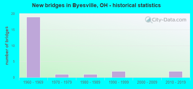
- New bridges - historical statistics
- 191960-1969
- 11970-1979
- 11980-1989
- 21990-1999
- 22010-2019

- Reconstructed bridges - Historical Statistics
- 12000-2009
- 22010-2019


- Bridge Condition - Deck
- 17.6%Excellent
- 11.8%Very good
- 52.9%Good
- 5.9%Satisfactory
- 11.8%Fair

- Bridge Condition - Superstructure
- 5.9%Excellent
- 23.5%Very good
- 52.9%Good
- 5.9%Satisfactory
- 11.8%Fair

- Bridge Condition - Substructure
- 29.4%Very good
- 35.3%Good
- 35.3%Satisfactory

- Bridge Condition - Channel
- 63.6%Good
- 36.4%Satisfactory
Find on map >> Show street view
Structure Number: 3001385, Location: AT JCT OF I-77 (Lat: 39.998169, Lng: -81.556100), Route carried "on" structure: Interstate 70, Year Built: 1965, Status: Open, Structure Length: 3.02m (9.91ft), Average Daily Traffic: 11,461 (year 2018), Truck Traffic: 35%, Average Future Daily Traffic: 15,908 (year 2038), Design Load: HS 20+Mod, Features Intersected: IR 70E OVER IR 77N
Minimum Vertical Clearance: 30+ m (98+ ft), Kilometerpoint: 15.997, Lanes on structure: 2, Lanes under structure: 2, Base Highway Network: Yes, Owner: State Highway Agency, Approaching Roadway Width: 26.8m (87.9ft), Material/Design: Steel, Design/Construction: Stringer/Multi-beam, Number Of Spans In Main Unit: 1, Length of Maximum Span: 29.3m (96.1ft), Curb-To-Curb Width: 24.5m (80.4ft), Out-to-Out Width: 25.1m (82.3ft)
Condition: Deck: Good, Superstructure: Good, Substructure: Satisfactory, Operating Rating: 44.7 metric tons, Method Used To Determine Operating Rating: Load Factor (LF) rating reported by rating factor (RF) method using MS18 loading, Inventory Rating: 26.9 metric tons, Method Used To Determine Inventory Rating: Load Factor (LF) rating reported by rating factor (RF) method using MS18 loading, Structural Evaluation: Equal to present minimum criteria, Deck Geometry: Superior to present desirable criteria, Underclear: Somewhat better than minimum adequacy, Approach Roadway Alignment: Equal to present desirable criteria, Designated Inspection Frequency: Every 12 months, Inspection Date: June 2021, Deck Structure Type: Concrete Cast-file-Place, Wearing Surface/Protective System: Wearing Surface: Integral Concrete
Find on map >> Show street view
Structure Number: 3001474, Location: AT SR 265 (Lat: 40.003581, Lng: -81.513319), Route carried "on" structure: Interstate 70, Year Built: 1965, Year Reconstructed: 2016, Status: Open, Structure Length: 13.66m (44.82ft), Average Daily Traffic: 15,357 (year 2017), Truck Traffic: 35%, Average Future Daily Traffic: 21,316 (year 2037), Design Load: HS 20+Mod, Features Intersected: IR 70 OVER SR 265
Minimum Vertical Clearance: 30+ m (98+ ft), Kilometerpoint: 19.827, Lanes on structure: 2, Lanes under structure: 2, Base Highway Network: Yes, Owner: State Highway Agency, Approaching Roadway Width: 16.3m (53.5ft), Skew: 5 degrees, Material/Design: Steel continuous, Design/Construction: Stringer/Multi-beam, Number Of Spans In Main Unit: 4, Length of Maximum Span: 39.0m (128.0ft), Curb-To-Curb Width: 16.3m (53.5ft), Out-to-Out Width: 17.2m (56.4ft)
Condition: Deck: Very good, Superstructure: Very good, Substructure: Very good, Operating Rating: 38.9 metric tons, Method Used To Determine Operating Rating: Load and Resistance Factor Rating (LRFR) rating reported by rating factor(RF) method using HL-93 loadings, Inventory Rating: 29.2 metric tons, Method Used To Determine Inventory Rating: Load and Resistance Factor Rating (LRFR) rating reported by rating factor(RF) method using HL-93 loadings, Structural Evaluation: Better than present minimum criteria, Deck Geometry: Superior to present desirable criteria, Underclear: Superior to present desirable criteria, Approach Roadway Alignment: Equal to present desirable criteria, Designated Inspection Frequency: Every 24 months, Inspection Date: June 2021, Deck Structure Type: Concrete Cast-file-Place, Wearing Surface/Protective System: Wearing Surface: Monolithic Concrete
Find on map >> Show street view
Structure Number: 3001504, Location: AT SR 265 (Lat: 40.003319, Lng: -81.512881), Route carried "on" structure: Interstate 70, Year Built: 1965, Year Reconstructed: 2016, Status: Open, Structure Length: 13.66m (44.82ft), Average Daily Traffic: 15,357 (year 2017), Truck Traffic: 35%, Average Future Daily Traffic: 21,316 (year 2037), Design Load: HS 20+Mod, Features Intersected: IR 70 OVER SR 265
Minimum Vertical Clearance: 30+ m (98+ ft), Kilometerpoint: 19.827, Lanes on structure: 2, Lanes under structure: 2, Base Highway Network: Yes, Owner: State Highway Agency, Approaching Roadway Width: 17.2m (56.4ft), Skew: 5 degrees, Material/Design: Steel continuous, Design/Construction: Stringer/Multi-beam, Number Of Spans In Main Unit: 4, Length of Maximum Span: 39.0m (128.0ft), Curb-To-Curb Width: 16.3m (53.5ft), Out-to-Out Width: 17.2m (56.4ft)
Condition: Deck: Excellent, Superstructure: Very good, Substructure: Very good, Operating Rating: 42.1 metric tons, Method Used To Determine Operating Rating: Load Factor (LF) rating reported by rating factor (RF) method using MS18 loading, Inventory Rating: 32.4 metric tons, Method Used To Determine Inventory Rating: Load Factor (LF) rating reported by rating factor (RF) method using MS18 loading, Structural Evaluation: Equal to present desirable criteria, Deck Geometry: Superior to present desirable criteria, Underclear: Superior to present desirable criteria, Approach Roadway Alignment: Equal to present desirable criteria, Designated Inspection Frequency: Every 24 months, Inspection Date: June 2021, Deck Structure Type: Concrete Cast-file-Place, Wearing Surface/Protective System: Wearing Surface: Monolithic Concrete
Find on map >> Show street view
Structure Number: 3001539, Location: 3.8 M W OF JCT SR 285 &40 (Lat: 40.003050, Lng: -81.504969), Route carried "on" structure: Interstate 70, Year Built: 1965, Status: Open, Structure Length: 5.24m (17.19ft), Average Daily Traffic: 15,357 (year 2018), Truck Traffic: 35%, Average Future Daily Traffic: 21,316 (year 2038), Design Load: HS 20+Mod, Features Intersected: IR 70 OVR LEATHRWOOD CRK
Minimum Vertical Clearance: 30+ m (98+ ft), Kilometerpoint: 20.519, Lanes on structure: 2, Base Highway Network: Yes, Owner: State Highway Agency, Approaching Roadway Width: 14.9m (48.9ft), Skew: 1 degrees, Material/Design: Steel continuous, Design/Construction: Stringer/Multi-beam, Number Of Spans In Main Unit: 3, Length of Maximum Span: 19.8m (65.0ft), Curb-To-Curb Width: 12.5m (41.0ft), Out-to-Out Width: 13.5m (44.3ft)
Condition: Deck: Good, Superstructure: Good, Substructure: Good, Channel: Satisfactory, Operating Rating: 42.1 metric tons, Method Used To Determine Operating Rating: Allowable Stress (AS) rating reported by rating factor (RF) method using MS18 loading, Inventory Rating: 32.4 metric tons, Method Used To Determine Inventory Rating: Allowable Stress (AS) rating reported by rating factor (RF) method using MS18 loading, Structural Evaluation: Better than present minimum criteria, Deck Geometry: Better than present minimum criteria, Waterway Adequacy: Better than present minimum criteria, Approach Roadway Alignment: Equal to present desirable criteria, Designated Inspection Frequency: Every 24 months, Inspection Date: June 2021, Deck Structure Type: Concrete Cast-file-Place, Wearing Surface/Protective System: Wearing Surface: Bituminous
Find on map >> Show street view
Structure Number: 3001563, Location: 3.8 M W OF JCT SR 285 &40 (Lat: 40.002819, Lng: -81.504900), Route carried "on" structure: Interstate 70, Year Built: 1965, Status: Open, Structure Length: 5.24m (17.19ft), Average Daily Traffic: 15,357 (year 2018), Truck Traffic: 35%, Average Future Daily Traffic: 21,316 (year 2038), Design Load: HS 20+Mod, Features Intersected: IR 70 OVR LEATHRWOOD CRK
Minimum Vertical Clearance: 30+ m (98+ ft), Kilometerpoint: 20.519, Lanes on structure: 2, Base Highway Network: Yes, Owner: State Highway Agency, Approaching Roadway Width: 14.9m (48.9ft), Skew: 1 degrees, Material/Design: Steel continuous, Design/Construction: Stringer/Multi-beam, Number Of Spans In Main Unit: 3, Length of Maximum Span: 19.8m (65.0ft), Curb-To-Curb Width: 12.5m (41.0ft), Out-to-Out Width: 13.5m (44.3ft)
Condition: Deck: Good, Superstructure: Good, Substructure: Good, Channel: Good, Operating Rating: 42.1 metric tons, Method Used To Determine Operating Rating: Allowable Stress (AS) rating reported by rating factor (RF) method using MS18 loading, Inventory Rating: 32.4 metric tons, Method Used To Determine Inventory Rating: Allowable Stress (AS) rating reported by rating factor (RF) method using MS18 loading, Structural Evaluation: Better than present minimum criteria, Deck Geometry: Better than present minimum criteria, Waterway Adequacy: Better than present minimum criteria, Approach Roadway Alignment: Equal to present desirable criteria, Designated Inspection Frequency: Every 24 months, Inspection Date: June 2021, Deck Structure Type: Concrete Cast-file-Place, Wearing Surface/Protective System: Wearing Surface: Bituminous
Find on map >> Show street view
Structure Number: 3002586, Location: AT JCT OF SR 209 (Lat: 39.969911, Lng: -81.531450), Route carried "on" structure: Interstate 77, Year Built: 1968, Status: Open, Structure Length: 4.48m (14.70ft), Average Daily Traffic: 9,596 (year 2018), Truck Traffic: 22%, Average Future Daily Traffic: 13,319 (year 2038), Design Load: HS 20+Mod, Features Intersected: I 77 OVER SR 209 & 821
Minimum Vertical Clearance: 30+ m (98+ ft), Kilometerpoint: 8.320, Lanes on structure: 2, Lanes under structure: 2, Base Highway Network: Yes, Owner: State Highway Agency, Approaching Roadway Width: 14.6m (47.9ft), Skew: 3 degrees, Material/Design: Steel continuous, Design/Construction: Stringer/Multi-beam, Number Of Spans In Main Unit: 3, Length of Maximum Span: 18.3m (60.0ft), Curb-To-Curb Width: 11.6m (38.1ft), Out-to-Out Width: 12.8m (42.0ft)
Condition: Deck: Good, Superstructure: Good, Substructure: Good, Operating Rating: 55.1 metric tons, Method Used To Determine Operating Rating: Load Factor (LF) rating reported by rating factor (RF) method using MS18 loading, Inventory Rating: 32.4 metric tons, Method Used To Determine Inventory Rating: Load Factor (LF) rating reported by rating factor (RF) method using MS18 loading, Structural Evaluation: Better than present minimum criteria, Deck Geometry: Equal to present minimum criteria, Underclear: Somewhat better than minimum adequacy, Approach Roadway Alignment: Better than present minimum criteria, Designated Inspection Frequency: Every 24 months, Inspection Date: May 2021, Deck Structure Type: Concrete Cast-file-Place, Wearing Surface/Protective System: Wearing Surface: Bituminous, Membrane: Built-up
Find on map >> Show street view
Structure Number: 3002616, Location: AT JCT OF SR 209 (Lat: 39.969919, Lng: -81.530961), Route carried "on" structure: Interstate 77, Year Built: 1968, Status: Open, Structure Length: 4.51m (14.80ft), Average Daily Traffic: 9,596 (year 2018), Truck Traffic: 22%, Average Future Daily Traffic: 13,319 (year 2038), Design Load: HS 20+Mod, Features Intersected: I 77 OVER SR 209 & 821
Minimum Vertical Clearance: 30+ m (98+ ft), Kilometerpoint: 8.320, Lanes on structure: 2, Lanes under structure: 2, Base Highway Network: Yes, Owner: State Highway Agency, Approaching Roadway Width: 19.5m (64.0ft), Skew: 3 degrees, Material/Design: Steel continuous, Design/Construction: Stringer/Multi-beam, Number Of Spans In Main Unit: 3, Length of Maximum Span: 18.3m (60.0ft), Curb-To-Curb Width: 17.7m (58.1ft), Out-to-Out Width: 19.0m (62.3ft)
Condition: Deck: Good, Superstructure: Satisfactory, Substructure: Satisfactory, Operating Rating: 42.1 metric tons, Method Used To Determine Operating Rating: Allowable Stress (AS) rating reported by rating factor (RF) method using MS18 loading, Inventory Rating: 32.4 metric tons, Method Used To Determine Inventory Rating: Allowable Stress (AS) rating reported by rating factor (RF) method using MS18 loading, Structural Evaluation: Equal to present minimum criteria, Deck Geometry: Superior to present desirable criteria, Underclear: Somewhat better than minimum adequacy, Approach Roadway Alignment: Better than present minimum criteria, Designated Inspection Frequency: Every 12 months, Inspection Date: May 2021, Deck Structure Type: Concrete Cast-file-Place, Wearing Surface/Protective System: Wearing Surface: Bituminous, Membrane: Built-up
Find on map >> Show street view
Structure Number: 3002675, Location: .8 M N OF JCT SR 209 (Lat: 39.978961, Lng: -81.540800), Route carried "on" structure: County highway C0043, Year Built: 1968, Status: Open, Structure Length: 8.63m (28.31ft), Average Daily Traffic: 1,626 (year 2018), Truck Traffic: 5%, Average Future Daily Traffic: 33,316 (year 2038), Design Load: H 15, Features Intersected: CR 43 OVER I-77, Facility Carried by Structure: CR 43
Minimum Vertical Clearance: 30+ m (98+ ft), Kilometerpoint: 160.918, Lanes on structure: 2, Lanes under structure: 4, Owner: State Highway Agency, Approaching Roadway Width: 9.8m (32.2ft), Material/Design: Steel continuous, Design/Construction: Stringer/Multi-beam, Number Of Spans In Main Unit: 4, Length of Maximum Span: 25.3m (83.0ft), Curb or Sidewalk Widths: Left: 0.5m (1.6ft), Right: 0.5m (1.6ft), Curb-To-Curb Width: 7.6m (24.9ft), Out-to-Out Width: 9.5m (31.2ft)
Condition: Deck: Fair, Superstructure: Fair, Substructure: Satisfactory, Operating Rating: 32.4 metric tons, Method Used To Determine Operating Rating: Load and Resistance Factor Rating (LRFR) rating reported by rating factor(RF) method using HL-93 loadings, Inventory Rating: 25.9 metric tons, Method Used To Determine Inventory Rating: Load and Resistance Factor Rating (LRFR) rating reported by rating factor(RF) method using HL-93 loadings, Structural Evaluation: Somewhat better than minimum adequacy, Deck Geometry: Meets minimum limits, Underclear: High priority of corrective action, Approach Roadway Alignment: Equal to present desirable criteria, Designated Inspection Frequency: Every 12 months, Inspection Date: May 2021, Deck Structure Type: Concrete Cast-file-Place, Wearing Surface/Protective System: Wearing Surface: Monolithic Concrete
Find on map >> Show street view
Structure Number: 3002705, Location: 1.9 M N OF JCT SR 209 (Lat: 39.992861, Lng: -81.550639), Route carried "on" structure: County highway C0035, Year Built: 1965, Status: Open, Structure Length: 8.53m (27.99ft), Average Daily Traffic: 2,533 (year 2017), Truck Traffic: 4%, Average Future Daily Traffic: 33,316 (year 2037), Design Load: HS 20+Mod, Features Intersected: CR 35 OVER I 77, Facility Carried by Structure: CR 35
Minimum Vertical Clearance: 30+ m (98+ ft), Kilometerpoint: 160.918, Lanes on structure: 2, Lanes under structure: 4, Owner: State Highway Agency, Approaching Roadway Width: 9.8m (32.2ft), Material/Design: Steel continuous, Design/Construction: Stringer/Multi-beam, Number Of Spans In Main Unit: 4, Length of Maximum Span: 25.0m (82.0ft), Curb-To-Curb Width: 8.4m (27.6ft), Out-to-Out Width: 9.5m (31.2ft)
Condition: Deck: Excellent, Superstructure: Very good, Substructure: Very good, Operating Rating: 32.4 metric tons, Method Used To Determine Operating Rating: Load and Resistance Factor Rating (LRFR) rating reported by rating factor(RF) method using HL-93 loadings, Inventory Rating: 25.9 metric tons, Method Used To Determine Inventory Rating: Load and Resistance Factor Rating (LRFR) rating reported by rating factor(RF) method using HL-93 loadings, Structural Evaluation: Equal to present minimum criteria, Deck Geometry: High priority of corrective action, Underclear: High priority of corrective action, Approach Roadway Alignment: Equal to present desirable criteria, Designated Inspection Frequency: Every 24 months, Inspection Date: May 2021, Deck Structure Type: Concrete Cast-file-Place, Wearing Surface/Protective System: Wearing Surface: Monolithic Concrete
Find on map >> Show street view
Structure Number: 3004325, Location: .1 M W OF JCT I 77 (Lat: 39.970111, Lng: -81.533150), Route carried "on" structure: State highway 209, Year Built: 1966, Status: Open, Structure Length: 7.13m (23.39ft), Average Daily Traffic: 7,318 (year 2015), Truck Traffic: 9%, Average Future Daily Traffic: 10,157 (year 2035), Design Load: H 20, Features Intersected: 209 & 821 OVER WILLS CR
Minimum Vertical Clearance: 30+ m (98+ ft), Kilometerpoint: 23.303, Lanes on structure: 2, Base Highway Network: Yes, Owner: State Highway Agency, Approaching Roadway Width: 13.4m (44.0ft), Skew: 3 degrees, Material/Design: Steel continuous, Design/Construction: Stringer/Multi-beam, Number Of Spans In Main Unit: 3, Length of Maximum Span: 23.5m (77.1ft), Curb-To-Curb Width: 13.4m (44.0ft), Out-to-Out Width: 13.4m (44.0ft)
Condition: Deck: Satisfactory, Superstructure: Good, Substructure: Satisfactory, Channel: Satisfactory, Operating Rating: 42.1 metric tons, Method Used To Determine Operating Rating: Allowable Stress (AS) rating reported by rating factor (RF) method using MS18 loading, Inventory Rating: 32.4 metric tons, Method Used To Determine Inventory Rating: Allowable Stress (AS) rating reported by rating factor (RF) method using MS18 loading, Structural Evaluation: Equal to present minimum criteria, Deck Geometry: Equal to present minimum criteria, Waterway Adequacy: Equal to present desirable criteria, Approach Roadway Alignment: Equal to present desirable criteria, Designated Inspection Frequency: Every 12 months, Underwater Inspection Frequency: Every 60 months, Inspection Date: November 2021, Underwater Inspection Date: August 2018, Deck Structure Type: Concrete Cast-file-Place, Wearing Surface/Protective System: Wearing Surface: Integral Concrete, Deck Protection: Epoxy Coated Reinforcing
Find on map >> Show street view
Structure Number: 3004457, Location: .6 M E OF JCT US 40 (Lat: 40.011039, Lng: -81.518939), Route carried "on" structure: State highway 265, Year Built: 1998, Status: Open, Structure Length: 0.67m (2.20ft), Average Daily Traffic: 2,424 (year 2015), Truck Traffic: 6%, Average Future Daily Traffic: 3,365 (year 2035), Design Load: HS 20+Mod, Features Intersected: TRIB OF LEATHERWOOD CRK
Minimum Vertical Clearance: 30+ m (98+ ft), Kilometerpoint: 0.950, Lanes on structure: 2, Owner: State Highway Agency, Approaching Roadway Width: 10.4m (34.1ft), Skew: 1 degrees, Material/Design: Concrete, Design/Construction: Culvert, Number Of Spans In Main Unit: 1, Length of Maximum Span: 6.1m (20.0ft)
Condition: Channel: Good, Culverts: Very good, Operating Rating: 32.4 metric tons, Method Used To Determine Operating Rating: Load and Resistance Factor Rating (LRFR) rating reported by rating factor(RF) method using HL-93 loadings, Inventory Rating: 25.9 metric tons, Method Used To Determine Inventory Rating: Load and Resistance Factor Rating (LRFR) rating reported by rating factor(RF) method using HL-93 loadings, Structural Evaluation: Equal to present minimum criteria, Waterway Adequacy: Equal to present desirable criteria, Approach Roadway Alignment: Somewhat better than minimum adequacy, Designated Inspection Frequency: Every 24 months, Inspection Date: July 2021, Wearing Surface/Protective System: Membrane: Built-up
Find on map >> Show street view
Structure Number: 3004481, Location: 1.1 M E OF JCT US 40 (Lat: 40.004931, Lng: -81.515000), Route carried "on" structure: State highway 265, Year Built: 1984, Status: Open, Structure Length: 4.30m (14.11ft), Average Daily Traffic: 2,424 (year 2015), Truck Traffic: 6%, Average Future Daily Traffic: 3,365 (year 2035), Design Load: HS 20+Mod, Features Intersected: OVER LEATHERWOOD CREEK
Minimum Vertical Clearance: 30+ m (98+ ft), Kilometerpoint: 1.738, Lanes on structure: 2, Owner: State Highway Agency, Approaching Roadway Width: 7.9m (25.9ft), Skew: 3 degrees, Material/Design: Steel continuous, Design/Construction: Stringer/Multi-beam, Number Of Spans In Main Unit: 2, Length of Maximum Span: 21.3m (69.9ft), Curb-To-Curb Width: 9.1m (29.9ft), Out-to-Out Width: 9.1m (29.9ft)
Condition: Deck: Good, Superstructure: Good, Substructure: Good, Channel: Good, Operating Rating: 42.1 metric tons, Method Used To Determine Operating Rating: Allowable Stress (AS) rating reported by rating factor (RF) method using MS18 loading, Inventory Rating: 32.4 metric tons, Method Used To Determine Inventory Rating: Allowable Stress (AS) rating reported by rating factor (RF) method using MS18 loading, Structural Evaluation: Better than present minimum criteria, Deck Geometry: Meets minimum limits, Waterway Adequacy: Equal to present desirable criteria, Approach Roadway Alignment: Equal to present desirable criteria, Designated Inspection Frequency: Every 24 months, Inspection Date: July 2021, Deck Structure Type: Concrete Cast-file-Place, Wearing Surface/Protective System: Wearing Surface: Monolithic Concrete, Deck Protection: Epoxy Coated Reinforcing
Find on map >> Show street view
Structure Number: 3030424, Location: 500FT S OF TOWNSHIP RD35 (Lat: 39.991661, Lng: -81.557961), Route carried "on" structure: County highway C0347, Year Built: 2015, Status: Open, Structure Length: 4.18m (13.71ft), Average Daily Traffic: 2,544 (year 2014), Truck Traffic: 10%, Average Future Daily Traffic: 3,104 (year 2034), Design Load: HL 93, Features Intersected: WILLS CREEK, Facility Carried by Structure: TOWNSHIP RD 347
Minimum Vertical Clearance: 30+ m (98+ ft), Kilometerpoint: 1.522, Lanes on structure: 2, Owner: County Highway Agency, Approaching Roadway Width: 6.7m (22.0ft), Material/Design: Steel, Design/Construction: Truss - Thru, Number Of Spans In Main Unit: 1, Length of Maximum Span: 41.1m (134.8ft), Curb-To-Curb Width: 7.3m (24.0ft), Out-to-Out Width: 7.3m (24.0ft)
Condition: Deck: Very good, Superstructure: Very good, Substructure: Very good, Channel: Good, Operating Rating: 40.8 metric tons, Method Used To Determine Operating Rating: Field evaluation and documented engineering judgment, Inventory Rating: 32.7 metric tons, Method Used To Determine Inventory Rating: Field evaluation and documented engineering judgment, Structural Evaluation: Equal to present desirable criteria, Deck Geometry: High priority of replacement, Waterway Adequacy: Equal to present minimum criteria, Approach Roadway Alignment: Equal to present minimum criteria, Designated Inspection Frequency: Every 12 months, Critical Feature Inspection Frequency: Every 24 months, Inspection Date: June 2021, Critical Feature Inspection Date: June 2021, Deck Structure Type: Concrete Cast-file-Place, Wearing Surface/Protective System: Wearing Surface: Monolithic Concrete, Deck Protection: Epoxy Coated Reinforcing
Find on map >> Show street view
Structure Number: 3030491, Location: 4 MI N of SR 313 (Lat: 39.950161, Lng: -81.524081), Route carried "on" structure: County highway C0035, Year Built: 2017, Status: Open, Structure Length: 1.08m (3.54ft), Average Daily Traffic: 1,215 (year 2017), Truck Traffic: 5%, Average Future Daily Traffic: 1,519 (year 2037), Design Load: HL 93, Features Intersected: Stream, Facility Carried by Structure: CR 35 Vocational R
Minimum Vertical Clearance: 30+ m (98+ ft), Kilometerpoint: 3.838, Lanes on structure: 2, Owner: County Highway Agency, Approaching Roadway Width: 6.1m (20.0ft), Material/Design: Prestressed concrete, Design/Construction: Box Beam or Girders - Multiple, Number Of Spans In Main Unit: 1, Length of Maximum Span: 9.1m (29.9ft), Curb-To-Curb Width: 6.1m (20.0ft), Out-to-Out Width: 6.1m (20.0ft)
Condition: Deck: Excellent, Superstructure: Excellent, Substructure: Very good, Channel: Satisfactory, Operating Rating: 51.8 metric tons, Method Used To Determine Operating Rating: Load and Resistance Factor Rating (LRFR) rating reported by rating factor(RF) method using HL-93 loadings, Inventory Rating: 42.1 metric tons, Method Used To Determine Inventory Rating: Load and Resistance Factor Rating (LRFR) rating reported by rating factor(RF) method using HL-93 loadings, Structural Evaluation: Equal to present desirable criteria, Deck Geometry: High priority of replacement, Waterway Adequacy: Better than present minimum criteria, Approach Roadway Alignment: Equal to present minimum criteria, Designated Inspection Frequency: Every 24 months, Inspection Date: July 2021, Deck Structure Type: Concrete Cast-file-Place, Wearing Surface/Protective System: Wearing Surface: Bituminous, Deck Protection: Epoxy Coated Reinforcing
Find on map >> Show street view
Structure Number: 3031926, Location: .2MI N OF INTERSTATEHWY70 (Lat: 40.011100, Lng: -81.531031), Route carried "on" structure: County highway T0452, Year Built: 1971, Year Reconstructed: 2014, Status: Open, Structure Length: 1.83m (6.00ft), Average Daily Traffic: 11 (year 2015), Truck Traffic: 18%, Average Future Daily Traffic: 15 (year 2035), Features Intersected: LEATHERWOOD CREEK, Facility Carried by Structure: TOWNSHIP RD 452
Minimum Vertical Clearance: 30+ m (98+ ft), Kilometerpoint: 37.031, Lanes on structure: 1, Owner: County Highway Agency, Approaching Roadway Width: 4.6m (15.1ft), Material/Design: Steel, Design/Construction: Stringer/Multi-beam, Number Of Spans In Main Unit: 1, Length of Maximum Span: 17.7m (58.1ft), Curb-To-Curb Width: 4.9m (16.1ft), Out-to-Out Width: 4.9m (16.1ft)
Condition: Deck: Good, Superstructure: Good, Substructure: Satisfactory, Channel: Satisfactory, Operating Rating: 42.1 metric tons, Method Used To Determine Operating Rating: Load Factor (LF) rating reported by rating factor (RF) method using MS18 loading, Inventory Rating: 25.9 metric tons, Method Used To Determine Inventory Rating: Load Factor (LF) rating reported by rating factor (RF) method using MS18 loading, Structural Evaluation: Equal to present minimum criteria, Deck Geometry: High priority of corrective action, Waterway Adequacy: Equal to present minimum criteria, Approach Roadway Alignment: Equal to present minimum criteria, Designated Inspection Frequency: Every 12 months, Inspection Date: June 2021, Deck Structure Type: Wood or Timber, Wearing Surface/Protective System: Wearing Surface: Bituminous
Find on map >> Show street view
Structure Number: 3032027, Location: 4 MI N SR 313 (Lat: 39.951250, Lng: -81.518781), Route carried "on" structure: County highway C0453, Year Built: 1967, Status: Open, Structure Length: 1.22m (4.00ft), Average Daily Traffic: 687 (year 2015), Truck Traffic: 7%, Average Future Daily Traffic: 954 (year 2035), Features Intersected: TRAIL RUN, Facility Carried by Structure: C453 BUFFALO MINE
Minimum Vertical Clearance: 30+ m (98+ ft), Kilometerpoint: 0.982, Lanes on structure: 1, Owner: County Highway Agency, Approaching Roadway Width: 6.7m (22.0ft), Material/Design: Prestressed concrete, Design/Construction: Box Beam or Girders - Multiple, Number Of Spans In Main Unit: 1, Length of Maximum Span: 11.9m (39.0ft), Curb-To-Curb Width: 7.3m (24.0ft), Out-to-Out Width: 7.3m (24.0ft)
Condition: Deck: Good, Superstructure: Good, Substructure: Good, Channel: Good, Operating Rating: 42.1 metric tons, Method Used To Determine Operating Rating: Load Factor (LF) rating reported by rating factor (RF) method using MS18 loading, Inventory Rating: 32.4 metric tons, Method Used To Determine Inventory Rating: Load Factor (LF) rating reported by rating factor (RF) method using MS18 loading, Structural Evaluation: Better than present minimum criteria, Deck Geometry: Meets minimum limits, Waterway Adequacy: Equal to present minimum criteria, Approach Roadway Alignment: Equal to present minimum criteria, Designated Inspection Frequency: Every 24 months, Inspection Date: July 2021, Deck Structure Type: Concrete Cast-file-Place, Wearing Surface/Protective System: Wearing Surface: Bituminous
Find on map >> Show street view
Structure Number: 3033937, Location: .2 MI. WEST OF INT. RT.77 (Lat: 39.977289, Lng: -81.542950), Route carried "on" structure: County highway C0043, Year Built: 1993, Status: Open, Structure Length: 3.35m (10.99ft), Average Daily Traffic: 1,626 (year 2015), Truck Traffic: 5%, Average Future Daily Traffic: 2,257 (year 2035), Design Load: HS 20, Features Intersected: CROSSES OVER WILLS CREEK, Facility Carried by Structure: COUNTY ROAD 43
Minimum Vertical Clearance: 30+ m (98+ ft), Kilometerpoint: 0.177, Lanes on structure: 1, Owner: County Highway Agency, Approaching Roadway Width: 6.1m (20.0ft), Material/Design: Steel, Design/Construction: Truss - Thru, Number Of Spans In Main Unit: 1, Length of Maximum Span: 32.9m (107.9ft), Curb-To-Curb Width: 4.7m (15.4ft), Out-to-Out Width: 4.7m (15.4ft)
Condition: Deck: Fair, Superstructure: Fair, Substructure: Satisfactory, Channel: Good, Operating Rating: 55.1 metric tons, Method Used To Determine Operating Rating: Load Factor (LF) rating reported by rating factor (RF) method using MS18 loading, Inventory Rating: 32.4 metric tons, Method Used To Determine Inventory Rating: Load Factor (LF) rating reported by rating factor (RF) method using MS18 loading, Structural Evaluation: Somewhat better than minimum adequacy, Deck Geometry: High priority of replacement, Waterway Adequacy: Superior to present desirable criteria, Approach Roadway Alignment: Equal to present desirable criteria, Designated Inspection Frequency: Every 12 months, Critical Feature Inspection Frequency: Every 24 months, Inspection Date: June 2021, Critical Feature Inspection Date: June 2021, Deck Structure Type: Corrugated Steel, Wearing Surface/Protective System: Wearing Surface: Bituminous
Find on map >> Show street view
Structure Number: 3035727, Location: 100FT E OF STATE HWY 821 (Lat: 39.940219, Lng: -81.548411), Route carried "on" structure: County highway T2360, Year Built: 1966, Status: Posted for load, Structure Length: 4.45m (14.60ft), Average Daily Traffic: 351 (year 2015), Truck Traffic: 7%, Average Future Daily Traffic: 487 (year 2035), Features Intersected: WILLS CREEK, Facility Carried by Structure: TOWNSHIP RD 2360
Minimum Vertical Clearance: 30+ m (98+ ft), Kilometerpoint: 1.625, Lanes on structure: 2, Owner: County Highway Agency, Approaching Roadway Width: 6.1m (20.0ft), Material/Design: Steel continuous, Design/Construction: Stringer/Multi-beam, Number Of Spans In Main Unit: 3, Length of Maximum Span: 16.8m (55.1ft), Curb-To-Curb Width: 7.3m (24.0ft), Out-to-Out Width: 7.3m (24.0ft)
Condition: Deck: Good, Superstructure: Good, Substructure: Good, Channel: Good, Operating Rating: 38.9 metric tons, Method Used To Determine Operating Rating: Load Factor (LF) rating reported by rating factor (RF) method using MS18 loading, Inventory Rating: 22.7 metric tons, Method Used To Determine Inventory Rating: Load Factor (LF) rating reported by rating factor (RF) method using MS18 loading, Structural Evaluation: Equal to present minimum criteria, Deck Geometry: Somewhat better than minimum adequacy, Waterway Adequacy: Equal to present minimum criteria, Approach Roadway Alignment: Equal to present desirable criteria, Bridge Posting: Required (Relationship of Operating Rating to Maximum Legal Load: 10.0 - 19.9% below), Designated Inspection Frequency: Every 12 months, Inspection Date: July 2021, Deck Structure Type: Concrete Cast-file-Place, Wearing Surface/Protective System: Wearing Surface: Monolithic Concrete
Find on map >> Show street view
Structure Number: 3001385, Location: AT JCT OF I-77 (Lat: 39.998169, Lng: -81.556100), Route carried "under" structure: Interstate 77, Year Built: 1965, Structure Length: 0. m, Average Daily Traffic: 6,144 (year 2015), Truck Traffic: 22%, Features Intersected: NB I77 UNDER EB I70, Facility Carried by Structure: I-70 EB & RAMP F H
Minimum Vertical Clearance: 4.90m (16.08ft), Kilometerpoint: 12.134, Lanes on structure: 2, Lanes under structure: 2, Material/Design: Steel, Design/Construction: Stringer/Multi-beam, Length of Maximum Span: 29.3m (96.1ft)
Find on map >> Show street view
Structure Number: 3001474, Location: AT SR 265 (Lat: 40.003581, Lng: -81.513319), Route carried "under" structure: State highway 265, Year Built: 1965, Structure Length: 0. m, Average Daily Traffic: 2,424 (year 2015), Truck Traffic: 6%, Features Intersected: SR265 UNDER I-70, Facility Carried by Structure: WEST BOUND I-70
Minimum Vertical Clearance: 8.23m (27.00ft), Kilometerpoint: 2.044, Lanes on structure: 2, Lanes under structure: 2, Material/Design: Steel continuous, Design/Construction: Stringer/Multi-beam, Length of Maximum Span: 39.0m (128.0ft)
Find on map >> Show street view
Structure Number: 3001504, Location: AT SR 265 (Lat: 40.003319, Lng: -81.512881), Route carried "under" structure: State highway 265, Year Built: 1965, Structure Length: 0. m, Average Daily Traffic: 2,424 (year 2015), Truck Traffic: 6%, Features Intersected: SR265 UNDER I-70, Facility Carried by Structure: EAST BOUND I-70
Minimum Vertical Clearance: 8.23m (27.00ft), Kilometerpoint: 2.108, Lanes on structure: 2, Lanes under structure: 2, Material/Design: Steel continuous, Design/Construction: Stringer/Multi-beam, Length of Maximum Span: 39.0m (128.0ft)
Find on map >> Show street view
Structure Number: 3002586, Location: AT JCT OF SR 209 (Lat: 39.969911, Lng: -81.531450), Route carried "under" structure: State highway 209, Year Built: 1968, Structure Length: 0. m, Average Daily Traffic: 7,318 (year 2015), Truck Traffic: 9%, Features Intersected: SR 209 & 821 UNDER SBI77, Facility Carried by Structure: SOUTH BOUND I-77
Minimum Vertical Clearance: 4.47m (14.67ft), Kilometerpoint: 23.416, Lanes on structure: 2, Lanes under structure: 2, Material/Design: Steel continuous, Design/Construction: Stringer/Multi-beam, Length of Maximum Span: 18.3m (60.0ft)
Find on map >> Show street view
Structure Number: 3002616, Location: AT JCT OF SR 209 (Lat: 39.969919, Lng: -81.530961), Route carried "under" structure: State highway 209, Year Built: 1968, Structure Length: 0. m, Average Daily Traffic: 2,243 (year 2015), Truck Traffic: 5%, Features Intersected: SR 209 & 821 UNDER NBI77, Facility Carried by Structure: NORTH BOUND I-77
Minimum Vertical Clearance: 4.93m (16.17ft), Kilometerpoint: 23.464, Lanes on structure: 2, Lanes under structure: 2, Material/Design: Steel continuous, Design/Construction: Stringer/Multi-beam, Length of Maximum Span: 18.3m (60.0ft)
Find on map >> Show street view
Structure Number: 3002675, Location: .8 M N OF JCT SR 209 (Lat: 39.978961, Lng: -81.540800), Route carried "under" structure: Interstate 77, Year Built: 1968, Structure Length: 0. m, Average Daily Traffic: 24,003 (year 2015), Truck Traffic: 22%, Features Intersected: I 77 UNDER CR 43, Facility Carried by Structure: CR 43
Minimum Vertical Clearance: 4.95m (16.24ft), Kilometerpoint: 9.640, Lanes on structure: 2, Lanes under structure: 4, Material/Design: Steel continuous, Design/Construction: Stringer/Multi-beam, Length of Maximum Span: 25.3m (83.0ft)
Find on map >> Show street view
Structure Number: 3002705, Location: 1.9 M N OF JCT SR 209 (Lat: 39.992861, Lng: -81.550639), Route carried "under" structure: Interstate 77, Year Built: 1965, Structure Length: 0. m, Average Daily Traffic: 24,003 (year 2015), Truck Traffic: 22%, Features Intersected: IR 77 UNDER CR 35, Facility Carried by Structure: CR 35
Minimum Vertical Clearance: 6.10m (20.01ft), Kilometerpoint: 11.394, Lanes on structure: 2, Lanes under structure: 4, Material/Design: Steel continuous, Design/Construction: Stringer/Multi-beam, Length of Maximum Span: 25.0m (82.0ft)