Bridge Statistics for Byrdstown, Tennessee (TN)
Condition, Traffic, Stress, Structural Evaluation, Project Costs
- National Bridge Inventory (NBI) Statistics
- 11Number of bridges
- 272ft / 83.2mTotal length
- $575,000Total costs
- 21,169Total average daily traffic
- 2,136Total average daily truck traffic
- 33,872Total future (year 2040) average daily traffic
- National Bridge Inventory (NBI) Registered Bridges for Byrdstown
- No street view available for this location
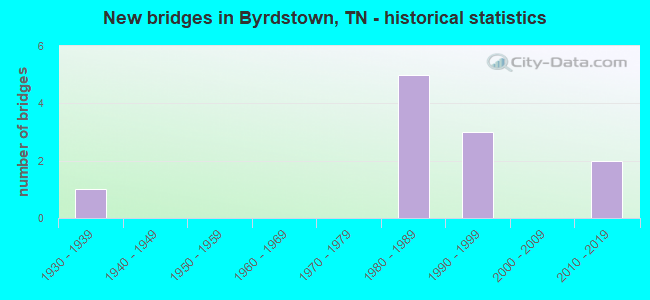
- New bridges - historical statistics
- 11930-1939
- 51980-1989
- 31990-1999
- 22010-2019


- Bridge Condition - Deck
- 75.0%Good
- 25.0%Satisfactory

- Bridge Condition - Superstructure
- 25.0%Good
- 50.0%Satisfactory
- 25.0%Fair

- Bridge Condition - Channel
- 18.2%Very good
- 54.5%Good
- 18.2%Satisfactory
- 9.1%Fair

- Bridge Condition - Culverts
- 71.4%Good
- 14.3%Satisfactory
- 14.3%Fair
Find on map >> Show street view
Structure Number: 690A0760001, Location: 1 MI FROM SR28 (Lat: 36.603031, Lng: -85.075350), Route carried "on" structure: County highway 76, Year Built: 1986, Status: Open, Structure Length: 0.79m (2.59ft), Average Daily Traffic: 40 (year 2022), Truck Traffic: 4%, Average Future Daily Traffic: 64 (year 2040), Design Load: HS 20, Features Intersected: SOUTH BRANCH
Minimum Vertical Clearance: 30+ m (98+ ft), Kilometerpoint: 2.091, Lanes on structure: 2, Owner: County Highway Agency, Approaching Roadway Width: 6.7m (22.0ft), Skew: 3 degrees, Material/Design: Concrete continuous, Design/Construction: Culvert, Number Of Spans In Main Unit: 2, Length of Maximum Span: 3.0m (9.8ft), Curb-To-Curb Width: 6.8m (22.3ft), Out-to-Out Width: 7.8m (25.6ft)
Condition: Channel: Satisfactory, Culverts: Good, Operating Rating: 64.8 metric tons, Method Used To Determine Operating Rating: Load Factor (LF), Inventory Rating: 38.7 metric tons, Method Used To Determine Inventory Rating: Load Factor (LF), Structural Evaluation: Better than present minimum criteria, Deck Geometry: Somewhat better than minimum adequacy, Waterway Adequacy: Better than present minimum criteria, Approach Roadway Alignment: Equal to present desirable criteria, Designated Inspection Frequency: Every 24 months, Inspection Date: January 2022
Find on map >> Show street view
Structure Number: 690A0990001, Location: SOUTHWEST OF SR28 (Lat: 36.557667, Lng: -85.071667), Route carried "on" structure: County highway 99, Year Built: 1994, Status: Open, Structure Length: 5.67m (18.60ft), Average Daily Traffic: 120 (year 2022), Truck Traffic: 2%, Average Future Daily Traffic: 192 (year 2040), Design Load: HS 20, Features Intersected: WOLF RIVER
Minimum Vertical Clearance: 30+ m (98+ ft), Kilometerpoint: 1.061, Lanes on structure: 2, Owner: County Highway Agency, Approaching Roadway Width: 5.8m (19.0ft), Skew: 2 degrees, Material/Design: Prestressed concrete continuous, Design/Construction: Box Beam or Girders - Single/Spread, Number Of Spans In Main Unit: 3, Length of Maximum Span: 21.3m (69.9ft), Curb-To-Curb Width: 6.7m (22.0ft), Out-to-Out Width: 7.4m (24.3ft)
Condition: Deck: Good, Superstructure: Satisfactory, Substructure: Good, Channel: Fair, Operating Rating: 51.3 metric tons, Method Used To Determine Operating Rating: Load Factor (LF), Inventory Rating: 30.6 metric tons, Method Used To Determine Inventory Rating: Load Factor (LF), Structural Evaluation: Equal to present minimum criteria, Deck Geometry: Meets minimum limits, Waterway Adequacy: Equal to present minimum criteria, Approach Roadway Alignment: Equal to present minimum criteria, Designated Inspection Frequency: Every 24 months, Inspection Date: January 2022, Deck Structure Type: Concrete Cast-file-Place, Wearing Surface/Protective System: Wearing Surface: Bituminous, Deck Protection: Epoxy Coated Reinforcing
Find on map >> Show street view
Structure Number: 690A1950001, Location: BRIDGE ROAD (Lat: 36.590000, Lng: -85.204711), Route carried "on" structure: County highway 195, Year Built: 2018, Status: Open, Structure Length: 0.72m (2.36ft), Average Daily Traffic: 40 (year 2022), Truck Traffic: 4%, Average Future Daily Traffic: 64 (year 2042), Design Load: HL 93, Features Intersected: SEWELL CREEK
Minimum Vertical Clearance: 30+ m (98+ ft), Kilometerpoint: 0.129, Lanes on structure: 1, Owner: County Highway Agency, Approaching Roadway Width: 4.9m (16.1ft), Skew: 2 degrees, Material/Design: Concrete continuous, Design/Construction: Culvert, Number Of Spans In Main Unit: 2, Length of Maximum Span: 3.0m (9.8ft), Curb-To-Curb Width: 4.3m (14.1ft), Out-to-Out Width: 5.9m (19.4ft)
Condition: Channel: Good, Culverts: Good, Operating Rating: 44.1 metric tons, Method Used To Determine Operating Rating: Assigned ratings based on Load and Resistance Factor Design (LRFD) reported by rating factor (RF) using HL93 loadings, Inventory Rating: 32.4 metric tons, Method Used To Determine Inventory Rating: Assigned ratings based on Load and Resistance Factor Design (LRFD) reported by rating factor (RF) using HL93 loadings, Structural Evaluation: Better than present minimum criteria, Deck Geometry: Equal to present minimum criteria, Waterway Adequacy: Better than present minimum criteria, Approach Roadway Alignment: Equal to present desirable criteria, Length Of Structure Improvement: 0.72m (2.36ft), Designated Inspection Frequency: Every 24 months, Inspection Date: January 2022, Bridge Improvement Cost: $57,000, Roadway Improvement Cost: $6,000, Total Project Cost: $86,000 ( Estimate for 2022)
Find on map >> Show street view
Structure Number: 69G00060001, Location: NORTH EAST OF BYRDSTOWN (Lat: 36.583689, Lng: -85.118311), Route carried "on" structure: State highway 295, Year Built: 1991, Status: Open, Structure Length: 8.05m (26.41ft), Average Daily Traffic: 615 (year 2020), Truck Traffic: 4%, Average Future Daily Traffic: 984 (year 2042), Design Load: HS 20, Features Intersected: WOLF RIVER
Minimum Vertical Clearance: 30+ m (98+ ft), Kilometerpoint: 0.917, Lanes on structure: 2, Owner: State Highway Agency, Approaching Roadway Width: 8.2m (26.9ft), Skew: 2 degrees, Material/Design: Prestressed concrete continuous, Design/Construction: Stringer/Multi-beam, Number Of Spans In Main Unit: 4, Length of Maximum Span: 19.8m (65.0ft), Curb-To-Curb Width: 8.5m (27.9ft), Out-to-Out Width: 9.1m (29.9ft)
Condition: Deck: Good, Superstructure: Good, Substructure: Good, Channel: Good, Operating Rating: 67.5 metric tons, Method Used To Determine Operating Rating: Load Factor (LF), Inventory Rating: 32.4 metric tons, Method Used To Determine Inventory Rating: Load Factor (LF), Structural Evaluation: Better than present minimum criteria, Deck Geometry: Somewhat better than minimum adequacy, Waterway Adequacy: Equal to present desirable criteria, Approach Roadway Alignment: Equal to present minimum criteria, Designated Inspection Frequency: Every 24 months, Inspection Date: November 2021, Deck Structure Type: Concrete Cast-file-Place, Wearing Surface/Protective System: Wearing Surface: Monolithic Concrete, Deck Protection: Epoxy Coated Reinforcing
Find on map >> Show street view
Structure Number: 69S42350001, Location: IN BYRDSTOWN (Lat: 36.567833, Lng: -85.122000), Route carried "on" structure: State highway 325, Year Built: 1987, Status: Open, Structure Length: 0.85m (2.79ft), Average Daily Traffic: 696 (year 2020), Truck Traffic: 5%, Average Future Daily Traffic: 1,114 (year 2042), Design Load: HS 20, Features Intersected: TOWN CREEK
Minimum Vertical Clearance: 30+ m (98+ ft), Kilometerpoint: 9.511, Lanes on structure: 2, Owner: State Highway Agency, Approaching Roadway Width: 7.3m (24.0ft), Skew: 4 degrees, Material/Design: Concrete, Design/Construction: Culvert, Number Of Spans In Main Unit: 1, Length of Maximum Span: 5.5m (18.0ft), Curb-To-Curb Width: 8.5m (27.9ft), Out-to-Out Width: 9.6m (31.5ft)
Condition: Channel: Good, Culverts: Satisfactory, Operating Rating: 89.1 metric tons, Method Used To Determine Operating Rating: Load Factor (LF), Inventory Rating: 32.4 metric tons, Method Used To Determine Inventory Rating: Load Factor (LF), Structural Evaluation: Equal to present minimum criteria, Deck Geometry: Somewhat better than minimum adequacy, Waterway Adequacy: Equal to present desirable criteria, Approach Roadway Alignment: Equal to present minimum criteria, Designated Inspection Frequency: Every 24 months, Inspection Date: November 2021, Deck Structure Type: Concrete Cast-file-Place, Wearing Surface/Protective System: Wearing Surface: Bituminous
Find on map >> Show street view
Structure Number: 69S42350003, Location: IN BYRDSTOWN (Lat: 36.566667, Lng: -85.121500), Route carried "on" structure: State highway 325, Year Built: 2012, Status: Open, Structure Length: 1.01m (3.31ft), Average Daily Traffic: 696 (year 2020), Truck Traffic: 5%, Average Future Daily Traffic: 1,114 (year 2042), Design Load: HS 20, Features Intersected: RINGBY CREEK
Minimum Vertical Clearance: 30+ m (98+ ft), Kilometerpoint: 9.817, Lanes on structure: 2, Owner: State Highway Agency, Approaching Roadway Width: 10.4m (34.1ft), Skew: 4 degrees, Material/Design: Concrete continuous, Design/Construction: Culvert, Number Of Spans In Main Unit: 2, Length of Maximum Span: 5.0m (16.4ft)
Condition: Channel: Good, Culverts: Good, Operating Rating: 44.1 metric tons, Method Used To Determine Operating Rating: Assigned ratings based on Load and Resistance Factor Design (LRFD) reported by rating factor (RF) using HL93 loadings, Inventory Rating: 32.4 metric tons, Method Used To Determine Inventory Rating: Assigned ratings based on Load and Resistance Factor Design (LRFD) reported by rating factor (RF) using HL93 loadings, Structural Evaluation: Better than present minimum criteria, Waterway Adequacy: Equal to present minimum criteria, Approach Roadway Alignment: Equal to present minimum criteria, Designated Inspection Frequency: Every 24 months, Inspection Date: November 2021, Wearing Surface/Protective System: Deck Protection: Epoxy Coated Reinforcing
Find on map >> Show street view
Structure Number: 69S42350005, Location: 3 MI E OF SR42 (Lat: 36.554833, Lng: -85.085333), Route carried "on" structure: State highway 325, Year Built: 1938, Status: Open, Structure Length: 1.01m (3.31ft), Average Daily Traffic: 696 (year 2020), Truck Traffic: 5%, Average Future Daily Traffic: 1,114 (year 2042), Features Intersected: WIDOW CREEK
Minimum Vertical Clearance: 30+ m (98+ ft), Kilometerpoint: 14.066, Lanes on structure: 2, Owner: State Highway Agency, Approaching Roadway Width: 6.7m (22.0ft), Material/Design: Concrete continuous, Design/Construction: Culvert, Number Of Spans In Main Unit: 3, Length of Maximum Span: 3.0m (9.8ft), Curb-To-Curb Width: 6.1m (20.0ft), Out-to-Out Width: 7.0m (23.0ft)
Condition: Channel: Good, Culverts: Good, Operating Rating: 38.7 metric tons, Method Used To Determine Operating Rating: Load Factor (LF), Inventory Rating: 22.5 metric tons, Method Used To Determine Inventory Rating: Load Factor (LF), Structural Evaluation: Equal to present minimum criteria, Deck Geometry: High priority of corrective action, Waterway Adequacy: Equal to present minimum criteria, Approach Roadway Alignment: Equal to present minimum criteria, Length Of Structure Improvement: 1.01m (3.31ft), Designated Inspection Frequency: Every 24 months, Inspection Date: November 2021, Bridge Improvement Cost: $87,000, Roadway Improvement Cost: $9,000, Total Project Cost: $131,000 ( Estimate for 2022), Deck Structure Type: Concrete Cast-file-Place, Wearing Surface/Protective System: Wearing Surface: Bituminous
Find on map >> Show street view
Structure Number: 69SR0420001, Location: 3.27 MI.N.OF OVERTON CO. (Lat: 36.532500, Lng: -85.161233), Route carried "on" structure: State highway 111, Year Built: 1996, Status: Open, Structure Length: 49.04m (160.89ft), Average Daily Traffic: 4,526 (year 2020), Truck Traffic: 11%, Average Future Daily Traffic: 7,242 (year 2042), Design Load: HS 20, Features Intersected: OBEY RIVER
Minimum Vertical Clearance: 30+ m (98+ ft), Kilometerpoint: 5.166, Lanes on structure: 2, Base Highway Network: Yes, Owner: State Highway Agency, Approaching Roadway Width: 13.4m (44.0ft), Material/Design: Steel continuous, Design/Construction: Stringer/Multi-beam, Number Of Spans In Main Unit: 5, Length of Maximum Span: 106.1m (348.1ft), Curb-To-Curb Width: 14.6m (47.9ft), Out-to-Out Width: 15.2m (49.9ft)
Condition: Deck: Good, Superstructure: Satisfactory, Substructure: Good, Channel: Very good, Operating Rating: 55.8 metric tons, Method Used To Determine Operating Rating: Assigned rating based on Load Factor Design (LFD) reported in metric tons, Inventory Rating: 32.4 metric tons, Method Used To Determine Inventory Rating: Assigned rating based on Load Factor Design (LFD) reported in metric tons, Structural Evaluation: Equal to present minimum criteria, Deck Geometry: Superior to present desirable criteria, Waterway Adequacy: Superior to present desirable criteria, Approach Roadway Alignment: Equal to present desirable criteria, Designated Inspection Frequency: Every 24 months, Underwater Inspection Frequency: Every 60 months, Inspection Date: November 2021, Underwater Inspection Date: May 2017, Deck Structure Type: Concrete Precast Panels, Wearing Surface/Protective System: Wearing Surface: Monolithic Concrete, Deck Protection: Epoxy Coated Reinforcing
Find on map >> Show street view
Structure Number: 69SR0420005, Location: 2 M SOUTH OF KY. STATE LN (Lat: 36.601700, Lng: -85.120867), Route carried "on" structure: State highway 111, Year Built: 1988, Status: Open, Structure Length: 13.96m (45.80ft), Average Daily Traffic: 4,580 (year 2020), Truck Traffic: 11%, Average Future Daily Traffic: 7,328 (year 2042), Design Load: HS 20, Features Intersected: WOLF RIVER
Minimum Vertical Clearance: 30+ m (98+ ft), Kilometerpoint: 15.450, Lanes on structure: 2, Base Highway Network: Yes, Owner: State Highway Agency, Approaching Roadway Width: 12.2m (40.0ft), Skew: 1 degrees, Material/Design: Steel continuous, Design/Construction: Stringer/Multi-beam, Number Of Spans In Main Unit: 4, Length of Maximum Span: 39.0m (128.0ft), Curb-To-Curb Width: 13.4m (44.0ft), Out-to-Out Width: 14.0m (45.9ft)
Condition: Deck: Satisfactory, Superstructure: Fair, Substructure: Good, Channel: Very good, Operating Rating: 55.8 metric tons, Method Used To Determine Operating Rating: Load Factor (LF), Inventory Rating: 33.3 metric tons, Method Used To Determine Inventory Rating: Load Factor (LF), Structural Evaluation: Somewhat better than minimum adequacy, Deck Geometry: Better than present minimum criteria, Waterway Adequacy: Equal to present desirable criteria, Approach Roadway Alignment: Equal to present desirable criteria, Designated Inspection Frequency: Every 24 months, Underwater Inspection Frequency: Every 60 months, Inspection Date: November 2021, Underwater Inspection Date: May 2017, Deck Structure Type: Concrete Cast-file-Place, Wearing Surface/Protective System: Wearing Surface: Monolithic Concrete, Deck Protection: Epoxy Coated Reinforcing
Find on map >> Show street view
Structure Number: 69SR0420007, Location: 1.5 M SOU OF KY STATE LN (Lat: 36.603619, Lng: -85.120069), Route carried "on" structure: State highway 111, Year Built: 1988, Status: Open, Structure Length: 1.16m (3.81ft), Average Daily Traffic: 4,580 (year 2020), Truck Traffic: 11%, Average Future Daily Traffic: 7,328 (year 2042), Design Load: HS 20, Features Intersected: BRANCH
Minimum Vertical Clearance: 30+ m (98+ ft), Kilometerpoint: 15.659, Lanes on structure: 2, Base Highway Network: Yes, Owner: State Highway Agency, Approaching Roadway Width: 12.2m (40.0ft), Skew: 5 degrees, Material/Design: Concrete continuous, Design/Construction: Culvert, Number Of Spans In Main Unit: 2, Length of Maximum Span: 3.0m (9.8ft)
Condition: Channel: Satisfactory, Culverts: Fair, Operating Rating: 54.0 metric tons, Method Used To Determine Operating Rating: Field evaluation and documented engineering judgment, Inventory Rating: 32.4 metric tons, Method Used To Determine Inventory Rating: Field evaluation and documented engineering judgment, Structural Evaluation: Somewhat better than minimum adequacy, Waterway Adequacy: Equal to present desirable criteria, Approach Roadway Alignment: Equal to present desirable criteria, Length Of Structure Improvement: 1.16m (3.81ft), Designated Inspection Frequency: Every 24 months, Inspection Date: November 2021, Bridge Improvement Cost: $238,000, Roadway Improvement Cost: $24,000, Total Project Cost: $358,000 ( Estimate for 2022)
Find on map >> Show street view
Structure Number: 69SR0420009, Location: 1 M SOUTH OF KY STATE LN (Lat: 36.607589, Lng: -85.114711), Route carried "on" structure: State highway 111, Year Built: 1988, Status: Open, Structure Length: 0.91m (2.99ft), Average Daily Traffic: 4,580 (year 2020), Truck Traffic: 11%, Average Future Daily Traffic: 7,328 (year 2042), Design Load: HS 20, Features Intersected: BRANCH
Minimum Vertical Clearance: 30+ m (98+ ft), Kilometerpoint: 16.335, Lanes on structure: 2, Base Highway Network: Yes, Owner: State Highway Agency, Approaching Roadway Width: 12.2m (40.0ft), Skew: 3 degrees, Material/Design: Concrete continuous, Design/Construction: Culvert, Number Of Spans In Main Unit: 2, Length of Maximum Span: 3.0m (9.8ft)
Condition: Channel: Good, Culverts: Good, Operating Rating: 54.0 metric tons, Method Used To Determine Operating Rating: Field evaluation and documented engineering judgment, Inventory Rating: 32.4 metric tons, Method Used To Determine Inventory Rating: Field evaluation and documented engineering judgment, Structural Evaluation: Better than present minimum criteria, Waterway Adequacy: Superior to present desirable criteria, Approach Roadway Alignment: Equal to present desirable criteria, Designated Inspection Frequency: Every 24 months, Inspection Date: November 2021