Bridge Statistics for Cade, Louisiana (LA)
Condition, Traffic, Stress, Structural Evaluation, Project Costs
- National Bridge Inventory (NBI) Statistics
- 11Number of bridges
- 43ft / 13.4mTotal length
- $323,000Total costs
- 35,808Total average daily traffic
- 2,074Total average daily truck traffic
- National Bridge Inventory (NBI) Registered Bridges for Cade
- No street view available for this location
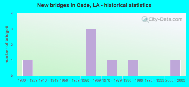
- New bridges - historical statistics
- 11930-1939
- 31960-1969
- 11970-1979
- 11980-1989
- 12000-2009


- Bridge Condition - Deck
- 33.3%Good
- 50.0%Satisfactory
- 16.7%Critical

- Bridge Condition - Superstructure
- 33.3%Good
- 50.0%Satisfactory
- 16.7%Critical

- Bridge Condition - Substructure
- 50.0%Good
- 16.7%Satisfactory
- 16.7%Fair
- 16.7%Poor

- Bridge Condition - Channel
- 28.6%Very good
- 57.1%Good
- 14.3%Satisfactory
Find on map >> Show street view
Structure Number: 32330014915411, Location: 0.5 MI E of US 90 Serv Rd (Lat: 30.021539, Lng: -91.902881), Route carried "on" structure: County highway , Year Built: 1966, Status: Posted for load, Structure Length: 1.19m (3.90ft), Average Daily Traffic: 323 (year 2020), Truck Traffic: 6%, Average Future Daily Traffic: 246 (year 2036), Design Load: H 15, Features Intersected: Segura Branch Canal, Facility Carried by Structure: Estis Rd
Minimum Vertical Clearance: 30+ m (98+ ft), Kilometerpoint: 0.000, Lanes on structure: 2, Owner: County Highway Agency, Approaching Roadway Width: 7.3m (24.0ft), Material/Design: Wood or Timber, Design/Construction: Stringer/Multi-beam, Number Of Spans In Main Unit: 2, Length of Maximum Span: 5.8m (19.0ft), Curb-To-Curb Width: 6.1m (20.0ft), Out-to-Out Width: 6.1m (20.0ft)
Condition: Deck: Satisfactory, Superstructure: Satisfactory, Substructure: Fair, Channel: Good, Operating Rating: 29.0 metric tons, Method Used To Determine Operating Rating: Allowable Stress (AS), Inventory Rating: 19.0 metric tons, Method Used To Determine Inventory Rating: Allowable Stress (AS), Structural Evaluation: Somewhat better than minimum adequacy, Deck Geometry: Meets minimum limits, Waterway Adequacy: Better than present minimum criteria, Approach Roadway Alignment: Equal to present desirable criteria, Bridge Posting: Required (Relationship of Operating Rating to Maximum Legal Load: 0.1 - 9.9% below), Length Of Structure Improvement: 1.83m (6.00ft), Designated Inspection Frequency: Every 24 months, Inspection Date: October 2020, Bridge Improvement Cost: $109,000, Total Project Cost: $163,000 ( Estimate for 2016), Deck Structure Type: Wood or Timber, Wearing Surface/Protective System: Wearing Surface: Bituminous
Find on map >> Show street view
Structure Number: 32330032915531, Location: 0.3 MI North of LA 88 (Lat: 30.054550, Lng: -91.922919), Route carried "on" structure: County highway , Year Built: 1965, Status: Closed, Structure Length: 1.16m (3.81ft), Average Daily Traffic: 829 (year 2020), Average Future Daily Traffic: 18 (year 2036), Design Load: HS 20, Features Intersected: COULEE, Facility Carried by Structure: Labit Rd
Minimum Vertical Clearance: 30+ m (98+ ft), Kilometerpoint: 0.000, Lanes on structure: 2, Owner: County Highway Agency, Approaching Roadway Width: 8.5m (27.9ft), Material/Design: Concrete, Design/Construction: Slab, Number Of Spans In Main Unit: 2, Length of Maximum Span: 5.8m (19.0ft), Curb-To-Curb Width: 6.2m (20.3ft), Out-to-Out Width: 6.7m (22.0ft)
Condition: Deck: Critical, Superstructure: Critical, Substructure: Poor, Channel: Very good, Operating Rating: 11.3 metric tons, Method Used To Determine Operating Rating: Load and Resistance Factor Rating (LRFR) rating reported by rating factor(RF) method using HL-93 loadings, Inventory Rating: 8.7 metric tons, Method Used To Determine Inventory Rating: Load and Resistance Factor Rating (LRFR) rating reported by rating factor(RF) method using HL-93 loadings, Deck Geometry: High priority of corrective action, Waterway Adequacy: Better than present minimum criteria, Approach Roadway Alignment: Equal to present desirable criteria, Bridge Posting: Required (Relationship of Operating Rating to Maximum Legal Load: > 39.9% below), Length Of Structure Improvement: 1.80m (5.91ft), Designated Inspection Frequency: Every 24 months, Other Special Inspection Frequency: Every 6 months, Inspection Date: October 2020, Other Special Inspection Date: October 2021, Bridge Improvement Cost: $107,000, Total Project Cost: $160,000 ( Estimate for 2016), Deck Structure Type: Concrete Precast Panels
Find on map >> Show street view
Structure Number: 35000040302491, Location: 0.23 MI N of LA 92-1 (Lat: 30.091261, Lng: -91.908600), Route carried "on" structure: State highway 182, Year Built: 1931, Status: Open, Structure Length: 1.04m (3.41ft), Average Daily Traffic: 13,800 (year 2016), Truck Traffic: 9%, Average Future Daily Traffic: 9,240 (year 2036), Design Load: H 15, Features Intersected: LASALLE COULEE
Minimum Vertical Clearance: 30+ m (98+ ft), Kilometerpoint: 3.982, Lanes on structure: 2, Owner: State Highway Agency, Approaching Roadway Width: 12.5m (41.0ft), Material/Design: Concrete, Design/Construction: Culvert, Number Of Spans In Main Unit: 6, Length of Maximum Span: 1.5m (4.9ft), Curb-To-Curb Width: 11.9m (39.0ft), Out-to-Out Width: 13.0m (42.7ft)
Condition: Channel: Good, Culverts: Satisfactory, Operating Rating: 32.4 metric tons, Method Used To Determine Operating Rating: Assigned ratings based on Load and Resistance Factor Design (LRFD) reported by rating factor (RF) using HL93 loadings, Inventory Rating: 24.9 metric tons, Method Used To Determine Inventory Rating: Assigned ratings based on Load and Resistance Factor Design (LRFD) reported by rating factor (RF) using HL93 loadings, Structural Evaluation: Equal to present minimum criteria, Deck Geometry: Somewhat better than minimum adequacy, Waterway Adequacy: Better than present minimum criteria, Approach Roadway Alignment: Equal to present desirable criteria, Designated Inspection Frequency: Every 24 months, Inspection Date: August 2020, Deck Structure Type: Concrete Cast-file-Place
Find on map >> Show street view
Structure Number: 35002130701901, Location: 1.5 MI East of US 90 (Lat: 30.088439, Lng: -91.922800), Route carried "on" structure: State highway 92, Year Built: 1973, Status: Open, Structure Length: 1.74m (5.71ft), Average Daily Traffic: 2,536 (year 2020), Truck Traffic: 9%, Average Future Daily Traffic: 2,790 (year 2041), Design Load: HS 20, Features Intersected: LASALLE COULEE
Minimum Vertical Clearance: 30+ m (98+ ft), Kilometerpoint: 2.433, Lanes on structure: 2, Owner: State Highway Agency, Approaching Roadway Width: 6.2m (20.3ft), Material/Design: Concrete, Design/Construction: Slab, Number Of Spans In Main Unit: 3, Length of Maximum Span: 5.8m (19.0ft), Curb-To-Curb Width: 8.6m (28.2ft), Out-to-Out Width: 9.5m (31.2ft)
Condition: Deck: Satisfactory, Superstructure: Satisfactory, Substructure: Satisfactory, Channel: Good, Operating Rating: 61.7 metric tons, Method Used To Determine Operating Rating: Load Factor (LF), Inventory Rating: 36.3 metric tons, Method Used To Determine Inventory Rating: Load Factor (LF), Structural Evaluation: Equal to present minimum criteria, Deck Geometry: Meets minimum limits, Approach Roadway Alignment: Equal to present desirable criteria, Designated Inspection Frequency: Every 24 months, Inspection Date: August 2021, Deck Structure Type: Concrete Precast Panels, Wearing Surface/Protective System: Wearing Surface: Bituminous
Find on map >> Show street view
Structure Number: 35002130801841, Location: 1.84 MI WEST OF LA 182 (Lat: 30.104331, Lng: -91.882600), Route carried "on" structure: State highway 92, Year Built: 2004, Status: Open, Structure Length: 3.63m (11.91ft), Average Daily Traffic: 4,500 (year 2016), Truck Traffic: 13%, Average Future Daily Traffic: 2,640 (year 2036), Design Load: HS 20, Features Intersected: DRAIN
Minimum Vertical Clearance: 30+ m (98+ ft), Kilometerpoint: 2.939, Lanes on structure: 2, Owner: State Highway Agency, Approaching Roadway Width: 13.1m (43.0ft), Material/Design: Concrete, Design/Construction: Slab, Number Of Spans In Main Unit: 6, Length of Maximum Span: 6.1m (20.0ft), Curb-To-Curb Width: 13.4m (44.0ft), Out-to-Out Width: 13.9m (45.6ft)
Condition: Deck: Good, Superstructure: Good, Substructure: Good, Channel: Good, Operating Rating: 50.5 metric tons, Method Used To Determine Operating Rating: Load and Resistance Factor Rating (LRFR) rating reported by rating factor(RF) method using HL-93 loadings, Inventory Rating: 38.9 metric tons, Method Used To Determine Inventory Rating: Load and Resistance Factor Rating (LRFR) rating reported by rating factor(RF) method using HL-93 loadings, Structural Evaluation: Better than present minimum criteria, Deck Geometry: Better than present minimum criteria, Waterway Adequacy: Equal to present desirable criteria, Approach Roadway Alignment: Equal to present minimum criteria, Designated Inspection Frequency: Every 24 months, Inspection Date: June 2020, Deck Structure Type: Concrete Cast-file-Place
Find on map >> Show street view
Structure Number: 35030050915211, Location: 1.6 Mi. W of La 31 (Lat: 30.083019, Lng: -91.869861), Route carried "on" structure: County highway , Year Built: 1985, Status: Open, Structure Length: 2.90m (9.51ft), Design Load: HS 20, Features Intersected: CYPRESS ISLAND COULEE, Facility Carried by Structure: LADY OF LAKE RD
Minimum Vertical Clearance: 30+ m (98+ ft), Kilometerpoint: 0.000, Lanes on structure: 2, Owner: County Highway Agency, Approaching Roadway Width: 8.5m (27.9ft), Material/Design: Concrete, Design/Construction: Slab, Number Of Spans In Main Unit: 5, Length of Maximum Span: 5.8m (19.0ft), Curb-To-Curb Width: 7.2m (23.6ft), Out-to-Out Width: 8.2m (26.9ft)
Condition: Deck: Good, Superstructure: Good, Substructure: Good, Channel: Very good, Operating Rating: 58.3 metric tons, Method Used To Determine Operating Rating: Load and Resistance Factor Rating (LRFR) rating reported by rating factor(RF) method using HL-93 loadings, Inventory Rating: 45.0 metric tons, Method Used To Determine Inventory Rating: Load and Resistance Factor Rating (LRFR) rating reported by rating factor(RF) method using HL-93 loadings, Structural Evaluation: Better than present minimum criteria, Deck Geometry: Somewhat better than minimum adequacy, Waterway Adequacy: Equal to present desirable criteria, Approach Roadway Alignment: Equal to present desirable criteria, Designated Inspection Frequency: Every 24 months, Inspection Date: October 2020, Deck Structure Type: Concrete Precast Panels, Wearing Surface/Protective System: Wearing Surface: Bituminous
Find on map >> Show street view
Structure Number: 35030067915421, Location: 1.1 Mi. NE of La 182 (Lat: 30.112239, Lng: -91.903950), Route carried "on" structure: County highway , Year Built: 1966, Status: Open, Structure Length: 1.74m (5.71ft), Average Daily Traffic: 220 (year 1971), Average Future Daily Traffic: 132 (year 2036), Design Load: HS 20, Features Intersected: LASALLE COULEE, Facility Carried by Structure: Duchamp Rd
Minimum Vertical Clearance: 30+ m (98+ ft), Kilometerpoint: 0.000, Lanes on structure: 2, Owner: County Highway Agency, Approaching Roadway Width: 7.9m (25.9ft), Material/Design: Concrete, Design/Construction: Slab, Number Of Spans In Main Unit: 3, Length of Maximum Span: 5.8m (19.0ft), Curb-To-Curb Width: 7.4m (24.3ft), Out-to-Out Width: 8.0m (26.2ft)
Condition: Deck: Satisfactory, Superstructure: Satisfactory, Substructure: Good, Channel: Satisfactory, Operating Rating: 23.0 metric tons, Method Used To Determine Operating Rating: Load and Resistance Factor Rating (LRFR) rating reported by rating factor(RF) method using HL-93 loadings, Inventory Rating: 17.8 metric tons, Method Used To Determine Inventory Rating: Load and Resistance Factor Rating (LRFR) rating reported by rating factor(RF) method using HL-93 loadings, Structural Evaluation: Somewhat better than minimum adequacy, Deck Geometry: Somewhat better than minimum adequacy, Waterway Adequacy: Equal to present minimum criteria, Approach Roadway Alignment: Equal to present desirable criteria, Designated Inspection Frequency: Every 24 months, Inspection Date: October 2020, Deck Structure Type: Wood or Timber
Find on map >> Show street view
Structure Number: 32304240401441, Location: 1.9 MI E OF LA 89 (Lat: 30.050931, Lng: -91.929189), Route carried "under" structure: State highway 88, Structure Length: 0. m, Average Daily Traffic: 3,400 (year 2016), Features Intersected: LA 88 WB UNDER US 90 EB
Minimum Vertical Clearance: 5.09m (16.70ft), Kilometerpoint: 5.493, Lanes on structure: 2, Lanes under structure: 2, Length of Maximum Span: 0.0m
Find on map >> Show street view
Structure Number: 32304240401441, Location: 1.9 MI E OF LA 89 (Lat: 30.050739, Lng: -91.929239), Route carried "under" structure: State highway 88, Structure Length: 0. m, Average Daily Traffic: 3,400 (year 2016), Features Intersected: LA 88 EB UNDER US 90 EB
Minimum Vertical Clearance: 5.15m (16.90ft), Kilometerpoint: 4.157, Lanes on structure: 2, Lanes under structure: 2, Length of Maximum Span: 0.0m
Find on map >> Show street view
Structure Number: 32304240401442, Location: 1.9 MI E OF LA 89 (Lat: 30.050931, Lng: -91.928869), Route carried "under" structure: State highway 88, Structure Length: 0. m, Average Daily Traffic: 3,400 (year 2016), Features Intersected: LA 88 WB UNDER US 90 WB
Minimum Vertical Clearance: 5.12m (16.80ft), Kilometerpoint: 5.462, Lanes on structure: 2, Lanes under structure: 2, Length of Maximum Span: 0.0m
Find on map >> Show street view
Structure Number: 32304240401442, Location: 1.9 MI E OF LA 89 (Lat: 30.050750, Lng: -91.928919), Route carried "under" structure: State highway 88, Structure Length: 0. m, Average Daily Traffic: 3,400 (year 2016), Features Intersected: LA 88 EB UNDER US 90 WB
Minimum Vertical Clearance: 5.12m (16.80ft), Kilometerpoint: 4.186, Lanes on structure: 2, Lanes under structure: 2, Length of Maximum Span: 0.0m