Bridge Statistics for Cadillac, Michigan (MI)
Condition, Traffic, Stress, Structural Evaluation, Project Costs
- National Bridge Inventory (NBI) Statistics
- 30Number of bridges
- 243ft / 73.9mTotal length
- $581,000Total costs
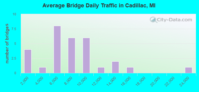
- 211,302Total average daily traffic
- 16,712Total average daily truck traffic
- National Bridge Inventory (NBI) Registered Bridges for Cadillac
- No street view available for this location
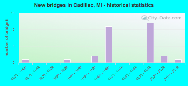
- New bridges - historical statistics
- 11900-1909
- 11930-1939
- 21950-1959
- 111960-1969
- 121990-1999
- 22000-2009
- 12010-2019
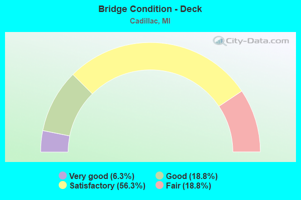
- Bridge Condition - Deck
- 6.3%Very good
- 18.8%Good
- 56.3%Satisfactory
- 18.8%Fair
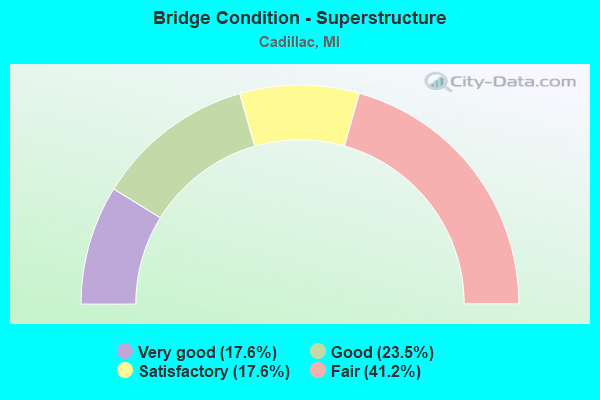
- Bridge Condition - Superstructure
- 17.6%Very good
- 23.5%Good
- 17.6%Satisfactory
- 41.2%Fair
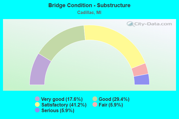
- Bridge Condition - Substructure
- 17.6%Very good
- 29.4%Good
- 41.2%Satisfactory
- 5.9%Fair
- 5.9%Serious
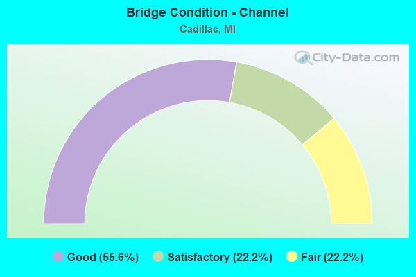
- Bridge Condition - Channel
- 55.6%Good
- 22.2%Satisfactory
- 22.2%Fair
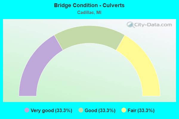
- Bridge Condition - Culverts
- 33.3%Very good
- 33.3%Good
- 33.3%Fair
Find on map >> Show street view
Structure Number: 12541, Location: 5 MI S OF CADILLAC (Lat: 44.179553, Lng: -85.424794), Route carried "on" structure: US 131, Year Built: 1966, Status: Open, Structure Length: 3.56m (11.68ft), Average Daily Traffic: 5,863 (year 2007), Truck Traffic: 13%, Average Future Daily Traffic: 8,615 (year 2018), Design Load: HS 20, Features Intersected: 50 MILE RD
Minimum Vertical Clearance: 30.48m (100.00ft), Kilometerpoint: 2.141, Lanes on structure: 2, Lanes under structure: 2, Base Highway Network: Yes (Inventory Route: 383, Subroute: 28), Owner: State Highway Agency, Approaching Roadway Width: 12.5m (41.0ft), Skew: 1 degrees, Material/Design: Prestressed concrete, Design/Construction: Stringer/Multi-beam, Number Of Spans In Main Unit: 3, Length of Maximum Span: 13.1m (43.0ft), Curb-To-Curb Width: 12.2m (40.0ft), Out-to-Out Width: 12.9m (42.3ft)
Condition: Deck: Satisfactory, Superstructure: Satisfactory, Substructure: Fair, Operating Rating: 68.4 metric tons, Method Used To Determine Operating Rating: Load Factor (LF) rating reported by rating factor (RF) method using MS18 loading, Inventory Rating: 40.8 metric tons, Method Used To Determine Inventory Rating: Load Factor (LF) rating reported by rating factor (RF) method using MS18 loading, Structural Evaluation: Somewhat better than minimum adequacy, Deck Geometry: Better than present minimum criteria, Underclear: Somewhat better than minimum adequacy, Approach Roadway Alignment: Somewhat better than minimum adequacy, Designated Inspection Frequency: Every 24 months, Inspection Date: October 2020, Deck Structure Type: Concrete Cast-file-Place, Wearing Surface/Protective System: Wearing Surface: Epoxy Overlay
Find on map >> Show street view
Structure Number: 12542, Location: 2.2 MI S OF CADILLAC (Lat: 44.205517, Lng: -85.412392), Route carried "on" structure: US 131, Year Built: 1966, Status: Open, Structure Length: 4.23m (13.88ft), Average Daily Traffic: 6,155 (year 2007), Truck Traffic: 8%, Average Future Daily Traffic: 6,615 (year 2018), Design Load: HS 20, Features Intersected: M-115
Minimum Vertical Clearance: 30.48m (100.00ft), Kilometerpoint: 5.271, Lanes on structure: 2, Lanes under structure: 4, Base Highway Network: Yes (Inventory Route: 383, Subroute: 28), Owner: State Highway Agency, Approaching Roadway Width: 12.5m (41.0ft), Material/Design: Steel, Design/Construction: Stringer/Multi-beam, Number Of Spans In Main Unit: 3, Length of Maximum Span: 22.2m (72.8ft), Curb-To-Curb Width: 11.7m (38.4ft), Out-to-Out Width: 12.9m (42.3ft)
Condition: Deck: Fair, Superstructure: Fair, Substructure: Satisfactory, Operating Rating: 67.7 metric tons, Method Used To Determine Operating Rating: Load Factor (LF) rating reported by rating factor (RF) method using MS18 loading, Inventory Rating: 40.5 metric tons, Method Used To Determine Inventory Rating: Load Factor (LF) rating reported by rating factor (RF) method using MS18 loading, Structural Evaluation: Somewhat better than minimum adequacy, Deck Geometry: Better than present minimum criteria, Underclear: Equal to present minimum criteria, Approach Roadway Alignment: Somewhat better than minimum adequacy, Designated Inspection Frequency: Every 17 months, Inspection Date: May 2021, Deck Structure Type: Concrete Cast-file-Place, Wearing Surface/Protective System: Wearing Surface: Epoxy Overlay
Find on map >> Show street view
Structure Number: 12543, Location: 1.8 MI S OF CADILLAC (Lat: 44.210619, Lng: -85.405867), Route carried "on" structure: County highway 8381, Year Built: 1966, Status: Open, Structure Length: 11.55m (37.89ft), Average Daily Traffic: 12,310 (year 2007), Truck Traffic: 8%, Average Future Daily Traffic: 13,229 (year 2018), Design Load: HS 20, Features Intersected: US-131, Facility Carried by Structure: OLD US-131
Minimum Vertical Clearance: 30.48m (100.00ft), Kilometerpoint: 5.964, Lanes on structure: 2, Lanes under structure: 4, Owner: State Highway Agency, Approaching Roadway Width: 11.5m (37.7ft), Skew: 4 degrees, Material/Design: Steel, Design/Construction: Stringer/Multi-beam, Number Of Spans In Main Unit: 4, Length of Maximum Span: 31.4m (103.0ft), Curb or Sidewalk Widths: Left: 0.6m (2.0ft), Right: 0.6m (2.0ft), Curb-To-Curb Width: 9.1m (29.9ft), Out-to-Out Width: 11.1m (36.4ft)
Condition: Deck: Satisfactory, Superstructure: Satisfactory, Substructure: Good, Operating Rating: 75.5 metric tons, Method Used To Determine Operating Rating: Load Factor (LF) rating reported by rating factor (RF) method using MS18 loading, Inventory Rating: 45.4 metric tons, Method Used To Determine Inventory Rating: Load Factor (LF) rating reported by rating factor (RF) method using MS18 loading, Structural Evaluation: Equal to present minimum criteria, Deck Geometry: Meets minimum limits, Underclear: Somewhat better than minimum adequacy, Approach Roadway Alignment: Somewhat better than minimum adequacy, Designated Inspection Frequency: Every 24 months, Inspection Date: October 2020, Deck Structure Type: Concrete Cast-file-Place, Wearing Surface/Protective System: Wearing Surface: Epoxy Overlay
Find on map >> Show street view
Structure Number: 12544, Location: 2.2 MI S OF CADILLAC (Lat: 44.205339, Lng: -85.412103), Route carried "on" structure: US 131, Year Built: 1966, Status: Open, Structure Length: 4.17m (13.68ft), Average Daily Traffic: 6,155 (year 2007), Truck Traffic: 8%, Average Future Daily Traffic: 6,615 (year 2018), Design Load: HS 20, Features Intersected: M-115
Minimum Vertical Clearance: 30.48m (100.00ft), Kilometerpoint: 5.227, Lanes on structure: 2, Lanes under structure: 4, Base Highway Network: Yes (Inventory Route: 383, Subroute: 27), Owner: State Highway Agency, Approaching Roadway Width: 12.5m (41.0ft), Material/Design: Steel, Design/Construction: Stringer/Multi-beam, Number Of Spans In Main Unit: 3, Length of Maximum Span: 22.2m (72.8ft), Curb-To-Curb Width: 11.7m (38.4ft), Out-to-Out Width: 12.9m (42.3ft)
Condition: Deck: Fair, Superstructure: Fair, Substructure: Satisfactory, Operating Rating: 94.3 metric tons, Method Used To Determine Operating Rating: Load Factor (LF) rating reported by rating factor (RF) method using MS18 loading, Inventory Rating: 56.4 metric tons, Method Used To Determine Inventory Rating: Load Factor (LF) rating reported by rating factor (RF) method using MS18 loading, Structural Evaluation: Somewhat better than minimum adequacy, Deck Geometry: Better than present minimum criteria, Underclear: Equal to present minimum criteria, Approach Roadway Alignment: Somewhat better than minimum adequacy, Designated Inspection Frequency: Every 17 months, Inspection Date: May 2021, Deck Structure Type: Concrete Cast-file-Place, Wearing Surface/Protective System: Wearing Surface: Epoxy Overlay
Find on map >> Show street view
Structure Number: 12545, Location: 5 MI S OF CADILLAC (Lat: 44.179569, Lng: -85.423933), Route carried "on" structure: US 131, Year Built: 1966, Status: Open, Structure Length: 3.59m (11.78ft), Average Daily Traffic: 5,863 (year 2007), Truck Traffic: 13%, Average Future Daily Traffic: 8,615 (year 2018), Design Load: HS 20, Features Intersected: 50 MILE RD
Minimum Vertical Clearance: 30.48m (100.00ft), Kilometerpoint: 2.132, Lanes on structure: 2, Lanes under structure: 2, Base Highway Network: Yes (Inventory Route: 383, Subroute: 27), Owner: State Highway Agency, Approaching Roadway Width: 12.5m (41.0ft), Skew: 1 degrees, Material/Design: Prestressed concrete, Design/Construction: Stringer/Multi-beam, Number Of Spans In Main Unit: 3, Length of Maximum Span: 12.8m (42.0ft), Curb-To-Curb Width: 12.2m (40.0ft), Out-to-Out Width: 12.9m (42.3ft)
Condition: Deck: Satisfactory, Superstructure: Fair, Substructure: Satisfactory, Operating Rating: 67.1 metric tons, Method Used To Determine Operating Rating: Load Factor (LF) rating reported by rating factor (RF) method using MS18 loading, Inventory Rating: 32.1 metric tons, Method Used To Determine Inventory Rating: Load Factor (LF) rating reported by rating factor (RF) method using MS18 loading, Structural Evaluation: Somewhat better than minimum adequacy, Deck Geometry: Better than present minimum criteria, Underclear: Somewhat better than minimum adequacy, Approach Roadway Alignment: Somewhat better than minimum adequacy, Designated Inspection Frequency: Every 24 months, Inspection Date: September 2020, Deck Structure Type: Concrete Cast-file-Place, Wearing Surface/Protective System: Wearing Surface: Epoxy Overlay
Find on map >> Show street view
Structure Number: 12546, Location: IN CADILLAC (Lat: 44.257111, Lng: -85.404714), Route carried "on" structure: Business US 131, Year Built: 1935, Year Reconstructed: 2011, Status: Open, Structure Length: 1.46m (4.79ft), Average Daily Traffic: 23,406 (year 2011), Truck Traffic: 3%, Average Future Daily Traffic: 25,800 (year 2031), Design Load: H 15, Features Intersected: CLAM RIVER
Minimum Vertical Clearance: 30.48m (100.00ft), Kilometerpoint: 4.630, Lanes on structure: 4, Base Highway Network: Yes (Inventory Route: 383, Subroute: 70), Owner: State Highway Agency, Approaching Roadway Width: 14.0m (45.9ft), Skew: 4 degrees, Material/Design: Steel, Design/Construction: Stringer/Multi-beam, Number Of Spans In Main Unit: 1, Length of Maximum Span: 14.0m (45.9ft), Curb or Sidewalk Widths: Left: 3.0m (9.8ft), Right: 3.0m (9.8ft), Curb-To-Curb Width: 14.0m (45.9ft), Out-to-Out Width: 20.9m (68.6ft)
Condition: Deck: Good, Superstructure: Fair, Substructure: Satisfactory, Channel: Satisfactory, Inventory Rating: 62.9 metric tons, Method Used To Determine Inventory Rating: Load Factor (LF), Structural Evaluation: Somewhat better than minimum adequacy, Deck Geometry: High priority of replacement, Waterway Adequacy: Equal to present minimum criteria, Approach Roadway Alignment: Equal to present minimum criteria, Designated Inspection Frequency: Every 24 months, Inspection Date: August 2020, Deck Structure Type: Concrete Cast-file-Place, Wearing Surface/Protective System: Wearing Surface: Epoxy Overlay, Deck Protection: Epoxy Coated Reinforcing
Find on map >> Show street view
Structure Number: 12573, Location: @ CADILLAC STATE PARK (Lat: 44.239386, Lng: -85.455281), Route carried "on" structure: State highway 115, Year Built: 1957, Year Reconstructed: 2007, Status: Open, Structure Length: 1.02m (3.35ft), Average Daily Traffic: 8,112 (year 2007), Truck Traffic: 14%, Average Future Daily Traffic: 13,722 (year 2025), Design Load: HS 20, Features Intersected: CADILLAC CANAL
Minimum Vertical Clearance: 30.48m (100.00ft), Kilometerpoint: 38.468, Lanes on structure: 2, Base Highway Network: Yes (Inventory Route: 112, Subroute: 10), Owner: State Highway Agency, Approaching Roadway Width: 11.6m (38.1ft), Skew: 1 degrees, Material/Design: Prestressed concrete, Design/Construction: Box Beam or Girders - Multiple, Number Of Spans In Main Unit: 1, Length of Maximum Span: 10.2m (33.5ft), Curb or Sidewalk Widths: Left: 2.1m (6.9ft), Right: 1.8m (5.9ft), Curb-To-Curb Width: 20.8m (68.2ft), Out-to-Out Width: 26.0m (85.3ft)
Condition: Deck: Satisfactory, Superstructure: Satisfactory, Substructure: Satisfactory, Channel: Fair, Operating Rating: 69.7 metric tons, Method Used To Determine Operating Rating: Load Factor (LF) rating reported by rating factor (RF) method using MS18 loading, Inventory Rating: 41.8 metric tons, Method Used To Determine Inventory Rating: Load Factor (LF) rating reported by rating factor (RF) method using MS18 loading, Structural Evaluation: Equal to present minimum criteria, Deck Geometry: Superior to present desirable criteria, Waterway Adequacy: Equal to present desirable criteria, Approach Roadway Alignment: Somewhat better than minimum adequacy, Designated Inspection Frequency: Every 24 months, Inspection Date: August 2020, Deck Structure Type: Concrete Cast-file-Place, Wearing Surface/Protective System: Wearing Surface: Epoxy Overlay, Deck Protection: Epoxy Coated Reinforcing
Find on map >> Show street view
Structure Number: 1259, Location: W HAYNES ST OVER CLAM RV (Lat: 44.253164, Lng: -85.410772), Route carried "on" structure: City street 2031, Year Built: 1952, Status: Open, Structure Length: 0.64m (2.10ft), Average Daily Traffic: 4,700 (year 2004), Truck Traffic: 10%, Average Future Daily Traffic: 8,500 (year 2024), Design Load: HS 20+Mod, Features Intersected: CLAM RIVER, Facility Carried by Structure: HAYNES STREET
Minimum Vertical Clearance: 30.48m (100.00ft), Kilometerpoint: 0.459, Lanes on structure: 2, Owner: City or Municipal Highway Agency, Approaching Roadway Width: 9.8m (32.2ft), Skew: 2 degrees, Material/Design: Concrete, Design/Construction: Slab, Number Of Spans In Main Unit: 1, Length of Maximum Span: 6.4m (21.0ft), Curb or Sidewalk Widths: Left: 1.8m (5.9ft), Right: 1.8m (5.9ft), Curb-To-Curb Width: 14.6m (47.9ft), Out-to-Out Width: 18.9m (62.0ft)
Condition: Deck: Fair, Superstructure: Fair, Substructure: Satisfactory, Channel: Fair, Operating Rating: 63.8 metric tons, Method Used To Determine Operating Rating: Field evaluation and documented engineering judgment, Inventory Rating: 38.3 metric tons, Method Used To Determine Inventory Rating: Field evaluation and documented engineering judgment, Structural Evaluation: Somewhat better than minimum adequacy, Deck Geometry: Superior to present desirable criteria, Waterway Adequacy: Meets minimum limits, Approach Roadway Alignment: Better than present minimum criteria, Length Of Structure Improvement: 1.28m (4.20ft), Designated Inspection Frequency: Every 24 months, Inspection Date: April 2021, Bridge Improvement Cost: $205,000, Roadway Improvement Cost: $100,000, Total Project Cost: $305,000, Deck Structure Type: Concrete Cast-file-Place, Wearing Surface/Protective System: Wearing Surface: Bituminous
Find on map >> Show street view
Structure Number: 12591, Location: IN CADILLAC (Lat: 44.256231, Lng: -85.405972), Route carried "on" structure: City street 2031, Year Built: 2005, Status: Open, Structure Length: 1.13m (3.71ft), Average Daily Traffic: 3,400 (year 2004), Truck Traffic: 5%, Average Future Daily Traffic: 6,100 (year 2024), Design Load: HS 20, Features Intersected: CLAM RIVER, Facility Carried by Structure: RIVER STREET
Minimum Vertical Clearance: 30.48m (100.00ft), Kilometerpoint: 2.446, Lanes on structure: 2, Owner: City or Municipal Highway Agency, Approaching Roadway Width: 8.2m (26.9ft), Skew: 4 degrees, Material/Design: Prestressed concrete, Design/Construction: Box Beam or Girders - Multiple, Number Of Spans In Main Unit: 1, Length of Maximum Span: 10.1m (33.1ft), Curb or Sidewalk Widths: Left: 2.1m (6.9ft), Right: 3.1m (10.2ft), Curb-To-Curb Width: 8.2m (26.9ft), Out-to-Out Width: 14.4m (47.2ft)
Condition: Deck: Good, Superstructure: Very good, Substructure: Very good, Channel: Good, Operating Rating: 77.4 metric tons, Method Used To Determine Operating Rating: Load Factor (LF) rating reported by rating factor (RF) method using MS18 loading, Inventory Rating: 46.3 metric tons, Method Used To Determine Inventory Rating: Load Factor (LF) rating reported by rating factor (RF) method using MS18 loading, Structural Evaluation: Equal to present desirable criteria, Deck Geometry: High priority of corrective action, Waterway Adequacy: Superior to present desirable criteria, Approach Roadway Alignment: Equal to present minimum criteria, Designated Inspection Frequency: Every 24 months, Inspection Date: April 2021, Deck Structure Type: Concrete Cast-file-Place, Wearing Surface/Protective System: Wearing Surface: Monolithic Concrete, Deck Protection: Epoxy Coated Reinforcing
Find on map >> Show street view
Structure Number: 12592, Location: 0.02 MI W OF PLETT ROAD (Lat: 44.267058, Lng: -85.396981), Route carried "on" structure: City street , Year Built: 1990, Status: Open, Structure Length: 0.79m (2.59ft), Average Daily Traffic: 4,700 (year 2004), Truck Traffic: 10%, Average Future Daily Traffic: 8,500 (year 2024), Design Load: HS 20+Mod, Features Intersected: CLAM RIVER, Facility Carried by Structure: 13 TH ST
Minimum Vertical Clearance: 30.48m (100.00ft), Kilometerpoint: 6.404, Lanes on structure: 2, Owner: City or Municipal Highway Agency, Approaching Roadway Width: 12.2m (40.0ft), Skew: 5 degrees, Material/Design: Concrete, Design/Construction: Culvert, Number Of Spans In Main Unit: 1, Length of Maximum Span: 6.1m (20.0ft)
Condition: Channel: Good, Culverts: Good, Operating Rating: 65.4 metric tons, Method Used To Determine Operating Rating: Field evaluation and documented engineering judgment, Inventory Rating: 42.5 metric tons, Method Used To Determine Inventory Rating: Field evaluation and documented engineering judgment, Structural Evaluation: Better than present minimum criteria, Waterway Adequacy: Equal to present minimum criteria, Approach Roadway Alignment: Equal to present desirable criteria, Designated Inspection Frequency: Every 24 months, Inspection Date: April 2021
Find on map >> Show street view
Structure Number: 12593, Location: IN CADILLAC (Lat: 44.255753, Lng: -85.406725), Route carried "on" structure: City street 2031, Year Built: 2000, Status: Open, Structure Length: 0.80m (2.62ft), Average Daily Traffic: 4,700 (year 2004), Truck Traffic: 10%, Average Future Daily Traffic: 8,500 (year 2024), Design Load: HS 20+Mod, Features Intersected: CLAM RIVER, Facility Carried by Structure: LAKE STREET
Minimum Vertical Clearance: 30.48m (100.00ft), Kilometerpoint: 1.709, Lanes on structure: 2, Owner: City or Municipal Highway Agency, Approaching Roadway Width: 9.1m (29.9ft), Skew: 8 degrees, Material/Design: Prestressed concrete, Design/Construction: Box Beam or Girders - Multiple, Number Of Spans In Main Unit: 1, Length of Maximum Span: 8.0m (26.2ft), Curb or Sidewalk Widths: Left: 2.6m (8.5ft), Right: 2.6m (8.5ft), Curb-To-Curb Width: 9.1m (29.9ft), Out-to-Out Width: 15.2m (49.9ft)
Condition: Deck: Very good, Superstructure: Good, Substructure: Very good, Channel: Good, Operating Rating: 51.8 metric tons, Method Used To Determine Operating Rating: Load and Resistance Factor Rating (LRFR) rating reported by rating factor(RF) method using HL-93 loadings, Inventory Rating: 40.2 metric tons, Method Used To Determine Inventory Rating: Load and Resistance Factor Rating (LRFR) rating reported by rating factor(RF) method using HL-93 loadings, Structural Evaluation: Better than present minimum criteria, Deck Geometry: Meets minimum limits, Waterway Adequacy: High priority of replacement, Approach Roadway Alignment: Equal to present desirable criteria, Length Of Structure Improvement: 2.62m (8.60ft), Designated Inspection Frequency: Every 24 months, Inspection Date: April 2021, Bridge Improvement Cost: $146,000, Roadway Improvement Cost: $15,000, Total Project Cost: $172,000, Deck Structure Type: Concrete Precast Panels, Wearing Surface/Protective System: Wearing Surface: Monolithic Concrete
Find on map >> Show street view
Structure Number: 12594, Location: IN CADILLAC (Lat: 44.251217, Lng: -85.410350), Route carried "on" structure: City street 2031, Year Built: 1968, Status: Open, Structure Length: 0.67m (2.20ft), Average Daily Traffic: 12,000 (year 2004), Truck Traffic: 5%, Average Future Daily Traffic: 15,000 (year 2024), Design Load: HS 20+Mod, Features Intersected: CLAM RIVER, Facility Carried by Structure: CHESTNUT
Minimum Vertical Clearance: 30.48m (100.00ft), Kilometerpoint: 2.168, Lanes on structure: 2, Owner: City or Municipal Highway Agency, Approaching Roadway Width: 11.0m (36.1ft), Skew: 1 degrees, Material/Design: Steel, Design/Construction: Culvert, Number Of Spans In Main Unit: 2, Length of Maximum Span: 2.7m (8.9ft), Curb or Sidewalk Widths: Left: 0.0m, Right: 1.3m (4.3ft), Out-to-Out Width: 22.6m (74.1ft)
Condition: Channel: Good, Culverts: Fair, Operating Rating: 34.0 metric tons, Method Used To Determine Operating Rating: Load Factor (LF) rating reported by rating factor (RF) method using MS18 loading, Inventory Rating: 20.4 metric tons, Method Used To Determine Inventory Rating: Load Factor (LF) rating reported by rating factor (RF) method using MS18 loading, Structural Evaluation: Somewhat better than minimum adequacy, Waterway Adequacy: Equal to present minimum criteria, Approach Roadway Alignment: Equal to present minimum criteria, Length Of Structure Improvement: 4.09m (13.42ft), Designated Inspection Frequency: Every 24 months, Inspection Date: April 2021, Bridge Improvement Cost: $20,000, Roadway Improvement Cost: $23,000, Total Project Cost: $43,000, Deck Structure Type: Concrete Cast-file-Place, Wearing Surface/Protective System: Wearing Surface: Bituminous
Find on map >> Show street view
Structure Number: 12595, Location: CITY OF CADILLAC (Lat: 44.259822, Lng: -85.402661), Route carried "on" structure: City street , Year Built: 1900, Status: Open, Structure Length: 0.73m (2.40ft), Average Daily Traffic: 560 (year 2002), Average Future Daily Traffic: 1,000 (year 2024), Design Load: HS 20+Mod, Features Intersected: CLAM RIVER, Facility Carried by Structure: POWERS STREET
Minimum Vertical Clearance: 30.48m (100.00ft), Kilometerpoint: 0.201, Lanes on structure: 2, Owner: City or Municipal Highway Agency, Approaching Roadway Width: 8.2m (26.9ft), Material/Design: Concrete, Design/Construction: Arch - Deck, Number Of Spans In Main Unit: 1, Length of Maximum Span: 7.3m (24.0ft), Curb or Sidewalk Widths: Left: 1.4m (4.6ft), Right: 1.4m (4.6ft), Curb-To-Curb Width: 7.6m (24.9ft), Out-to-Out Width: 11.1m (36.4ft)
Condition: Superstructure: Fair, Substructure: Serious, Channel: Satisfactory, Operating Rating: 65.4 metric tons, Method Used To Determine Operating Rating: Field evaluation and documented engineering judgment, Inventory Rating: 49.1 metric tons, Method Used To Determine Inventory Rating: Field evaluation and documented engineering judgment, Structural Evaluation: High priority of corrective action, Deck Geometry: Meets minimum limits, Waterway Adequacy: High priority of corrective action, Approach Roadway Alignment: Better than present minimum criteria, Length Of Structure Improvement: 2.26m (7.41ft), Designated Inspection Frequency: Every 12 months, Inspection Date: April 2021, Bridge Improvement Cost: $28,000, Roadway Improvement Cost: $33,000, Total Project Cost: $61,000, Deck Structure Type: Concrete Cast-file-Place, Wearing Surface/Protective System: Wearing Surface: Bituminous
Find on map >> Show street view
Structure Number: 12738, Location: 1/4 MI EAST OF CADILLAC (Lat: 44.252569, Lng: -85.370497), Route carried "on" structure: State highway 55, Year Built: 1997, Status: Open, Structure Length: 6.25m (20.51ft), Average Daily Traffic: 10,045 (year 2007), Truck Traffic: 6%, Average Future Daily Traffic: 9,222 (year 2018), Design Load: HS 25 or greater, Features Intersected: US-131
Minimum Vertical Clearance: 30.48m (100.00ft), Kilometerpoint: 2.507, Lanes on structure: 2, Lanes under structure: 4, Base Highway Network: Yes (Inventory Route: 112, Subroute: 1), Owner: State Highway Agency, Approaching Roadway Width: 17.1m (56.1ft), Skew: 3 degrees, Material/Design: Prestressed concrete, Design/Construction: Stringer/Multi-beam, Number Of Spans In Main Unit: 2, Length of Maximum Span: 33.3m (109.3ft), Curb-To-Curb Width: 18.3m (60.0ft), Out-to-Out Width: 19.3m (63.3ft)
Condition: Deck: Satisfactory, Superstructure: Good, Substructure: Satisfactory, Operating Rating: 62.5 metric tons, Method Used To Determine Operating Rating: Load Factor (LF) rating reported by rating factor (RF) method using MS18 loading, Inventory Rating: 36.3 metric tons, Method Used To Determine Inventory Rating: Load Factor (LF) rating reported by rating factor (RF) method using MS18 loading, Structural Evaluation: Equal to present minimum criteria, Deck Geometry: Superior to present desirable criteria, Underclear: Somewhat better than minimum adequacy, Approach Roadway Alignment: Equal to present desirable criteria, Designated Inspection Frequency: Every 24 months, Inspection Date: August 2020, Deck Structure Type: Concrete Cast-file-Place, Wearing Surface/Protective System: Wearing Surface: Epoxy Overlay, Deck Protection: Epoxy Coated Reinforcing
Find on map >> Show street view
Structure Number: 12739, Location: CITY OF CADILLAC (Lat: 44.256450, Lng: -85.376883), Route carried "on" structure: County highway , Year Built: 1997, Status: Open, Structure Length: 5.85m (19.19ft), Average Daily Traffic: 9,500 (year 1999), Average Future Daily Traffic: 10,440 (year 2015), Design Load: HS 25 or greater, Features Intersected: US-131, Facility Carried by Structure: CROSBY RD
Minimum Vertical Clearance: 30.48m (100.00ft), Kilometerpoint: 1.740, Lanes on structure: 2, Lanes under structure: 5, Owner: State Highway Agency, Approaching Roadway Width: 12.2m (40.0ft), Skew: 2 degrees, Material/Design: Prestressed concrete, Design/Construction: Stringer/Multi-beam, Number Of Spans In Main Unit: 2, Length of Maximum Span: 34.7m (113.8ft), Curb-To-Curb Width: 13.4m (44.0ft), Out-to-Out Width: 14.4m (47.2ft)
Condition: Deck: Good, Superstructure: Good, Substructure: Good, Operating Rating: 64.2 metric tons, Method Used To Determine Operating Rating: Load Factor (LF) rating reported by rating factor (RF) method using MS18 loading, Inventory Rating: 38.6 metric tons, Method Used To Determine Inventory Rating: Load Factor (LF) rating reported by rating factor (RF) method using MS18 loading, Structural Evaluation: Better than present minimum criteria, Deck Geometry: Equal to present minimum criteria, Underclear: Somewhat better than minimum adequacy, Approach Roadway Alignment: Equal to present desirable criteria, Designated Inspection Frequency: Every 24 months, Inspection Date: August 2020, Deck Structure Type: Concrete Cast-file-Place, Wearing Surface/Protective System: Wearing Surface: Epoxy Overlay, Deck Protection: Epoxy Coated Reinforcing
Find on map >> Show street view
Structure Number: 12778, Location: CLAM LAKE TWP SEC 10 (Lat: 44.235239, Lng: -85.373772), Route carried "on" structure: US 131, Year Built: 1998, Status: Open, Structure Length: 3.72m (12.20ft), Average Daily Traffic: 5,489 (year 2018), Truck Traffic: 13%, Average Future Daily Traffic: 6,312 (year 2038), Design Load: HS 25 or greater, Features Intersected: MDOT RR CORRIDOR
Minimum Vertical Clearance: 30.48m (100.00ft), Kilometerpoint: 9.756, Lanes on structure: 2, Base Highway Network: Yes (Inventory Route: 383, Subroute: 27), Owner: State Highway Agency, Approaching Roadway Width: 14.0m (45.9ft), Skew: 1 degrees, Material/Design: Prestressed concrete, Design/Construction: Stringer/Multi-beam, Number Of Spans In Main Unit: 1, Length of Maximum Span: 35.6m (116.8ft), Curb-To-Curb Width: 13.4m (44.0ft), Out-to-Out Width: 14.4m (47.2ft)
Condition: Deck: Satisfactory, Superstructure: Good, Substructure: Good, Operating Rating: 74.2 metric tons, Method Used To Determine Operating Rating: Load Factor (LF) rating reported by rating factor (RF) method using MS18 loading, Inventory Rating: 45.7 metric tons, Method Used To Determine Inventory Rating: Load Factor (LF) rating reported by rating factor (RF) method using MS18 loading, Structural Evaluation: Better than present minimum criteria, Deck Geometry: Superior to present desirable criteria, Underclear: Equal to present minimum criteria, Approach Roadway Alignment: Superior to present desirable criteria, Designated Inspection Frequency: Every 24 months, Inspection Date: September 2020, Deck Structure Type: Concrete Cast-file-Place, Wearing Surface/Protective System: Wearing Surface: Epoxy Overlay, Deck Protection: Epoxy Coated Reinforcing
Find on map >> Show street view
Structure Number: 1278, Location: CLAM LAKE TWP SEC 10 (Lat: 44.231664, Lng: -85.378875), Route carried "on" structure: County highway , Year Built: 1998, Status: Open, Structure Length: 7.45m (24.44ft), Average Daily Traffic: 1,200 (year 1998), Truck Traffic: 5%, Average Future Daily Traffic: 1,440 (year 2010), Design Load: HS 20, Features Intersected: US-131, Facility Carried by Structure: WHALEY ROAD
Minimum Vertical Clearance: 30.48m (100.00ft), Kilometerpoint: 6.188, Lanes on structure: 2, Lanes under structure: 4, Owner: State Highway Agency, Approaching Roadway Width: 14.0m (45.9ft), Skew: 1 degrees, Material/Design: Prestressed concrete, Design/Construction: Stringer/Multi-beam, Number Of Spans In Main Unit: 2, Length of Maximum Span: 39.2m (128.6ft), Curb-To-Curb Width: 13.4m (44.0ft), Out-to-Out Width: 14.4m (47.2ft)
Condition: Deck: Satisfactory, Superstructure: Fair, Substructure: Good, Operating Rating: 47.3 metric tons, Method Used To Determine Operating Rating: Load and Resistance Factor Rating (LRFR) rating reported by rating factor(RF) method using HL-93 loadings, Inventory Rating: 27.9 metric tons, Method Used To Determine Inventory Rating: Load and Resistance Factor Rating (LRFR) rating reported by rating factor(RF) method using HL-93 loadings, Structural Evaluation: Somewhat better than minimum adequacy, Deck Geometry: Equal to present desirable criteria, Underclear: Better than present minimum criteria, Approach Roadway Alignment: Equal to present desirable criteria, Designated Inspection Frequency: Every 24 months, Inspection Date: October 2020, Deck Structure Type: Concrete Cast-file-Place, Wearing Surface/Protective System: Wearing Surface: Epoxy Overlay, Deck Protection: Epoxy Coated Reinforcing
Find on map >> Show street view
Structure Number: 12828, Location: CLAM LAKE TWP SEC 15 & 16 (Lat: 44.219533, Lng: -85.396031), Route carried "on" structure: US 3, Year Built: 1999, Status: Open, Structure Length: 7.78m (25.52ft), Average Daily Traffic: 6,155 (year 2007), Truck Traffic: 8%, Average Future Daily Traffic: 4,896 (year 2018), Design Load: HS 25 or greater, Features Intersected: BL US-131 (S 43 ROAD)
Minimum Vertical Clearance: 30.48m (100.00ft), Kilometerpoint: 7.265, Lanes on structure: 2, Lanes under structure: 4, Base Highway Network: Yes (Inventory Route: 383, Subroute: 27), Owner: State Highway Agency, Approaching Roadway Width: 13.4m (44.0ft), Skew: 4 degrees, Material/Design: Prestressed concrete, Design/Construction: Stringer/Multi-beam, Number Of Spans In Main Unit: 3, Length of Maximum Span: 44.5m (146.0ft), Curb-To-Curb Width: 13.7m (44.9ft), Out-to-Out Width: 14.7m (48.2ft)
Condition: Deck: Satisfactory, Superstructure: Very good, Substructure: Good, Operating Rating: 69.7 metric tons, Method Used To Determine Operating Rating: Load Factor (LF) rating reported by rating factor (RF) method using MS18 loading, Inventory Rating: 41.8 metric tons, Method Used To Determine Inventory Rating: Load Factor (LF) rating reported by rating factor (RF) method using MS18 loading, Structural Evaluation: Better than present minimum criteria, Deck Geometry: Superior to present desirable criteria, Underclear: Better than present minimum criteria, Approach Roadway Alignment: Equal to present desirable criteria, Designated Inspection Frequency: Every 24 months, Inspection Date: September 2020, Deck Structure Type: Concrete Cast-file-Place, Wearing Surface/Protective System: Wearing Surface: Epoxy Overlay, Deck Protection: Epoxy Coated Reinforcing
Find on map >> Show street view
Structure Number: 12829, Location: CLAM LAKE TWP SEC 15 & 16 (Lat: 44.219872, Lng: -85.396056), Route carried "on" structure: US 131, Year Built: 1999, Status: Open, Structure Length: 7.79m (25.56ft), Average Daily Traffic: 6,155 (year 2007), Truck Traffic: 8%, Average Future Daily Traffic: 4,896 (year 2018), Design Load: HS 25 or greater, Features Intersected: BL US-131 (S 43 ROAD)
Minimum Vertical Clearance: 30.48m (100.00ft), Kilometerpoint: 7.336, Lanes on structure: 2, Lanes under structure: 4, Base Highway Network: Yes (Inventory Route: 383, Subroute: 28), Owner: State Highway Agency, Approaching Roadway Width: 13.4m (44.0ft), Skew: 4 degrees, Material/Design: Prestressed concrete, Design/Construction: Stringer/Multi-beam, Number Of Spans In Main Unit: 3, Length of Maximum Span: 44.8m (147.0ft), Curb-To-Curb Width: 13.7m (44.9ft), Out-to-Out Width: 14.7m (48.2ft)
Condition: Deck: Satisfactory, Superstructure: Very good, Substructure: Very good, Operating Rating: 66.7 metric tons, Method Used To Determine Operating Rating: Load Factor (LF) rating reported by rating factor (RF) method using MS18 loading, Inventory Rating: 39.9 metric tons, Method Used To Determine Inventory Rating: Load Factor (LF) rating reported by rating factor (RF) method using MS18 loading, Structural Evaluation: Equal to present desirable criteria, Deck Geometry: Superior to present desirable criteria, Underclear: Equal to present minimum criteria, Approach Roadway Alignment: Equal to present desirable criteria, Designated Inspection Frequency: Every 24 months, Inspection Date: September 2020, Deck Structure Type: Concrete Cast-file-Place, Wearing Surface/Protective System: Wearing Surface: Epoxy Overlay, Deck Protection: Epoxy Coated Reinforcing
Find on map >> Show street view
Structure Number: 13631, Location: N OF 13TH STREET (Lat: 44.267306, Lng: -85.396533), Route carried "on" structure: County highway , Year Built: 2012, Status: Open, Structure Length: 0.68m (2.23ft), Average Daily Traffic: 6,000 (year 2011), Truck Traffic: 6%, Average Future Daily Traffic: 8,081 (year 2031), Design Load: HL 93, Features Intersected: CLAM RIVER, Facility Carried by Structure: PLETT RD
Minimum Vertical Clearance: 30.48m (100.00ft), Kilometerpoint: 0.830, Lanes on structure: 2, Owner: County Highway Agency, Approaching Roadway Width: 11.3m (37.1ft), Skew: 1 degrees, Material/Design: Concrete, Design/Construction: Culvert, Number Of Spans In Main Unit: 1, Length of Maximum Span: 6.2m (20.3ft), Curb-To-Curb Width: 10.7m (35.1ft), Out-to-Out Width: 16.5m (54.1ft)
Condition: Channel: Good, Culverts: Very good, Operating Rating: 52.8 metric tons, Method Used To Determine Operating Rating: Load and Resistance Factor Rating (LRFR) rating reported by rating factor(RF) method using HL-93 loadings, Inventory Rating: 40.8 metric tons, Method Used To Determine Inventory Rating: Load and Resistance Factor Rating (LRFR) rating reported by rating factor(RF) method using HL-93 loadings, Structural Evaluation: Equal to present desirable criteria, Deck Geometry: Meets minimum limits, Waterway Adequacy: Equal to present desirable criteria, Approach Roadway Alignment: Better than present minimum criteria, Designated Inspection Frequency: Every 24 months, Inspection Date: July 2020, Wearing Surface/Protective System: Wearing Surface: Bituminous
Find on map >> Show street view
Structure Number: 12541, Location: 5 MI S OF CADILLAC (Lat: 44.179553, Lng: -85.424794), Route carried "under" structure: County highway , Year Built: 1966, Structure Length: 0. m, Average Daily Traffic: 60 (year 1974), Features Intersected: 50 MILE RD, Facility Carried by Structure: US-131 SB
Minimum Vertical Clearance: 4.39m (14.40ft), Kilometerpoint: 1.587, Lanes on structure: 2, Lanes under structure: 2, Material/Design: Prestressed concrete, Design/Construction: Stringer/Multi-beam, Length of Maximum Span: 13.1m (43.0ft)
Find on map >> Show street view
Structure Number: 12542, Location: 2.2 MI S OF CADILLAC (Lat: 44.205517, Lng: -85.412392), Route carried "under" structure: State highway 115, Year Built: 1966, Structure Length: 0. m, Average Daily Traffic: 6,002 (year 2007), Truck Traffic: 14%, Features Intersected: M-115, Facility Carried by Structure: US-131 SB
Minimum Vertical Clearance: 4.83m (15.85ft), Kilometerpoint: 43.642, Lanes on structure: 2, Lanes under structure: 4, Material/Design: Steel, Design/Construction: Stringer/Multi-beam, Length of Maximum Span: 22.2m (72.8ft)
Find on map >> Show street view
Structure Number: 12543, Location: 1.8 MI S OF CADILLAC (Lat: 44.210619, Lng: -85.405867), Route carried "under" structure: US 131, Year Built: 1966, Structure Length: 0. m, Average Daily Traffic: 14,000 (year 1995), Truck Traffic: 7%, Features Intersected: US-131
Minimum Vertical Clearance: 5.54m (18.18ft), Kilometerpoint: 5.015, Lanes on structure: 2, Lanes under structure: 4, Material/Design: Steel, Design/Construction: Stringer/Multi-beam, Length of Maximum Span: 31.4m (103.0ft)
Find on map >> Show street view
Structure Number: 12544, Location: 2.2 MI S OF CADILLAC (Lat: 44.205339, Lng: -85.412103), Route carried "under" structure: State highway 115, Year Built: 1966, Structure Length: 0. m, Average Daily Traffic: 9,548 (year 2007), Truck Traffic: 8%, Features Intersected: M-115, Facility Carried by Structure: US-131 NB
Minimum Vertical Clearance: 4.52m (14.83ft), Kilometerpoint: 43.673, Lanes on structure: 2, Lanes under structure: 4, Material/Design: Steel, Design/Construction: Stringer/Multi-beam, Length of Maximum Span: 22.2m (72.8ft)
Find on map >> Show street view
Structure Number: 12545, Location: 5 MI S OF CADILLAC (Lat: 44.179569, Lng: -85.423933), Route carried "under" structure: County highway , Year Built: 1966, Structure Length: 0. m, Average Daily Traffic: 60 (year 1974), Features Intersected: 50 MILE RD, Facility Carried by Structure: US-131 NB
Minimum Vertical Clearance: 4.39m (14.40ft), Kilometerpoint: 1.656, Lanes on structure: 2, Lanes under structure: 2, Material/Design: Prestressed concrete, Design/Construction: Stringer/Multi-beam, Length of Maximum Span: 12.8m (42.0ft)
Find on map >> Show street view
Structure Number: 12738, Location: 1/4 MI EAST OF CADILLAC (Lat: 44.252569, Lng: -85.370497), Route carried "under" structure: US 131, Year Built: 1997, Structure Length: 0. m, Average Daily Traffic: 9,838 (year 2007), Truck Traffic: 11%, Features Intersected: US-131, Facility Carried by Structure: M-55
Minimum Vertical Clearance: 6.10m (20.01ft), Kilometerpoint: 11.866, Lanes on structure: 2, Lanes under structure: 4, Material/Design: Prestressed concrete, Design/Construction: Stringer/Multi-beam, Length of Maximum Span: 33.3m (109.3ft)
Find on map >> Show street view
Structure Number: 12739, Location: CITY OF CADILLAC (Lat: 44.256450, Lng: -85.376883), Route carried "under" structure: US 131, Year Built: 1997, Structure Length: 0. m, Average Daily Traffic: 8,510 (year 2007), Truck Traffic: 11%, Features Intersected: US-131, Facility Carried by Structure: CROSBY RD
Minimum Vertical Clearance: 4.98m (16.34ft), Kilometerpoint: 12.536, Lanes on structure: 2, Lanes under structure: 5, Material/Design: Prestressed concrete, Design/Construction: Stringer/Multi-beam, Length of Maximum Span: 34.7m (113.8ft)
Find on map >> Show street view
Structure Number: 1278, Location: CLAM LAKE TWP SEC 10 (Lat: 44.231664, Lng: -85.378875), Route carried "under" structure: US 131, Year Built: 1998, Structure Length: 0. m, Average Daily Traffic: 9,838 (year 2007), Truck Traffic: 8%, Features Intersected: US-131, Facility Carried by Structure: WHALEY ROAD
Minimum Vertical Clearance: 5.84m (19.16ft), Kilometerpoint: 9.185, Lanes on structure: 2, Lanes under structure: 4, Material/Design: Prestressed concrete, Design/Construction: Stringer/Multi-beam, Length of Maximum Span: 39.2m (128.6ft)
Find on map >> Show street view
Structure Number: 12828, Location: CLAM LAKE TWP SEC 15 & 16 (Lat: 44.219533, Lng: -85.396031), Route carried "under" structure: County highway , Year Built: 1999, Structure Length: 0. m, Average Daily Traffic: 5,489 (year 2007), Truck Traffic: 10%, Features Intersected: BL US-131 (S 43 ROAD), Facility Carried by Structure: US-131 NB
Minimum Vertical Clearance: 4.85m (15.91ft), Kilometerpoint: 0.278, Lanes on structure: 2, Lanes under structure: 4, Material/Design: Prestressed concrete, Design/Construction: Stringer/Multi-beam, Length of Maximum Span: 44.5m (146.0ft)
Find on map >> Show street view
Structure Number: 12829, Location: CLAM LAKE TWP SEC 15 & 16 (Lat: 44.219872, Lng: -85.396056), Route carried "under" structure: Business US 131, Year Built: 1999, Structure Length: 0. m, Average Daily Traffic: 5,489 (year 2007), Truck Traffic: 10%, Features Intersected: BL US-131 (S 43 ROAD)
Minimum Vertical Clearance: 4.98m (16.34ft), Kilometerpoint: 0.317, Lanes on structure: 2, Lanes under structure: 4, Material/Design: Prestressed concrete, Design/Construction: Stringer/Multi-beam, Length of Maximum Span: 44.8m (147.0ft)