Bridge Statistics for Cadiz, Ohio (OH)
Condition, Traffic, Stress, Structural Evaluation, Project Costs
- National Bridge Inventory (NBI) Statistics
- 34Number of bridges
- 233ft / 71.2mTotal length
- $1,189,000Total costs
- 77,912Total average daily traffic
- 15,426Total average daily truck traffic
- National Bridge Inventory (NBI) Registered Bridges for Cadiz
- No street view available for this location
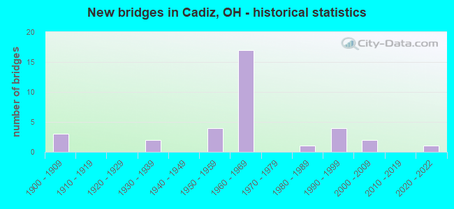
- New bridges - historical statistics
- 31900-1909
- 21930-1939
- 41950-1959
- 171960-1969
- 11980-1989
- 41990-1999
- 22000-2009
- 12020-2022

- Reconstructed bridges - Historical Statistics
- 31970-1979
- 21980-1989
- 81990-1999
- 12000-2009
- 12010-2019


- Bridge Condition - Deck
- 11.5%Excellent
- 15.4%Very good
- 38.5%Good
- 15.4%Satisfactory
- 11.5%Fair
- 7.7%Poor

- Bridge Condition - Superstructure
- 11.5%Excellent
- 23.1%Very good
- 30.8%Good
- 15.4%Satisfactory
- 7.7%Fair
- 7.7%Poor
- 3.8%Serious

- Bridge Condition - Substructure
- 3.8%Excellent
- 15.4%Very good
- 30.8%Good
- 34.6%Satisfactory
- 11.5%Fair
- 3.8%Poor

- Bridge Condition - Channel
- 21.1%Very good
- 5.3%Good
- 63.2%Satisfactory
- 10.5%Poor

- Bridge Condition - Culverts
- 33.3%Very good
- 33.3%Good
- 33.3%Satisfactory
Find on map >> Show street view
Structure Number: 3400166, Location: 4.33 MI N OF SR 149 (Lat: 40.234169, Lng: -81.003289), Route carried "on" structure: State highway 9, Year Built: 1996, Status: Open, Structure Length: 0.87m (2.85ft), Average Daily Traffic: 3,918 (year 2015), Truck Traffic: 11%, Average Future Daily Traffic: 5,438 (year 2035), Design Load: HS 20+Mod, Features Intersected: BR MID FORK SHORT CR
Minimum Vertical Clearance: 30+ m (98+ ft), Kilometerpoint: 9.077, Lanes on structure: 2, Owner: State Highway Agency, Approaching Roadway Width: 9.8m (32.2ft), Material/Design: Concrete, Design/Construction: Slab, Number Of Spans In Main Unit: 1, Length of Maximum Span: 8.2m (26.9ft), Curb-To-Curb Width: 10.4m (34.1ft), Out-to-Out Width: 10.4m (34.1ft)
Condition: Deck: Very good, Superstructure: Very good, Substructure: Good, Channel: Satisfactory, Operating Rating: 97.2 metric tons, Method Used To Determine Operating Rating: Load Factor (LF) rating reported by rating factor (RF) method using MS18 loading, Inventory Rating: 68.0 metric tons, Method Used To Determine Inventory Rating: Load Factor (LF) rating reported by rating factor (RF) method using MS18 loading, Structural Evaluation: Better than present minimum criteria, Deck Geometry: Somewhat better than minimum adequacy, Waterway Adequacy: Superior to present desirable criteria, Approach Roadway Alignment: Somewhat better than minimum adequacy, Designated Inspection Frequency: Every 24 months, Inspection Date: March 2021, Deck Structure Type: Concrete Cast-file-Place, Wearing Surface/Protective System: Wearing Surface: Monolithic Concrete, Deck Protection: Epoxy Coated Reinforcing
Find on map >> Show street view
Structure Number: 340022, Location: CADIZ 2.57 M S OF US 22 (Lat: 40.250389, Lng: -81.001319), Route carried "on" structure: State highway 9, Year Built: 2004, Status: Open, Structure Length: 0.62m (2.03ft), Average Daily Traffic: 3,918 (year 2015), Truck Traffic: 8%, Average Future Daily Traffic: 5,438 (year 2035), Design Load: HS 25 or greater, Features Intersected: SALLY BUFFALO CREEK
Minimum Vertical Clearance: 30+ m (98+ ft), Kilometerpoint: 11.040, Lanes on structure: 2, Owner: State Highway Agency, Approaching Roadway Width: 9.8m (32.2ft), Skew: 3 degrees, Material/Design: Concrete, Design/Construction: Culvert, Number Of Spans In Main Unit: 1, Length of Maximum Span: 6.2m (20.3ft)
Condition: Channel: Satisfactory, Culverts: Very good, Operating Rating: 42.1 metric tons, Method Used To Determine Operating Rating: Load Factor (LF) rating reported by rating factor (RF) method using MS18 loading, Inventory Rating: 32.4 metric tons, Method Used To Determine Inventory Rating: Load Factor (LF) rating reported by rating factor (RF) method using MS18 loading, Structural Evaluation: Equal to present desirable criteria, Waterway Adequacy: Superior to present desirable criteria, Approach Roadway Alignment: Equal to present desirable criteria, Designated Inspection Frequency: Every 24 months, Inspection Date: March 2021
Find on map >> Show street view
Structure Number: 3400328, Location: 3.5 MI. NORTH OF USR 22 (Lat: 40.320669, Lng: -81.029061), Route carried "on" structure: State highway 9, Year Built: 1991, Status: Open, Structure Length: 1.95m (6.40ft), Average Daily Traffic: 2,759 (year 2015), Truck Traffic: 9%, Average Future Daily Traffic: 3,829 (year 2035), Design Load: HS 20+Mod, Features Intersected: CLEAR FORK CREEK
Minimum Vertical Clearance: 30+ m (98+ ft), Kilometerpoint: 20.921, Lanes on structure: 2, Base Highway Network: Yes, Owner: State Highway Agency, Approaching Roadway Width: 12.2m (40.0ft), Skew: 1 degrees, Material/Design: Prestressed concrete, Design/Construction: Box Beam or Girders - Multiple, Number Of Spans In Main Unit: 1, Length of Maximum Span: 19.5m (64.0ft), Curb-To-Curb Width: 12.2m (40.0ft), Out-to-Out Width: 12.3m (40.4ft)
Condition: Deck: Excellent, Superstructure: Excellent, Substructure: Very good, Channel: Satisfactory, Operating Rating: 42.1 metric tons, Method Used To Determine Operating Rating: Load Factor (LF) rating reported by rating factor (RF) method using MS18 loading, Inventory Rating: 32.4 metric tons, Method Used To Determine Inventory Rating: Load Factor (LF) rating reported by rating factor (RF) method using MS18 loading, Structural Evaluation: Equal to present desirable criteria, Deck Geometry: Equal to present minimum criteria, Waterway Adequacy: Superior to present desirable criteria, Approach Roadway Alignment: Equal to present desirable criteria, Designated Inspection Frequency: Every 24 months, Inspection Date: March 2021, Deck Structure Type: Concrete Cast-file-Place, Wearing Surface/Protective System: Wearing Surface: Bituminous, Membrane: Built-up
Find on map >> Show street view
Structure Number: 3400735, Location: 1.84 MI E. SR 519 (Lat: 40.235200, Lng: -81.080831), Route carried "on" structure: US 22, Year Built: 1990, Status: Open, Structure Length: 2.35m (7.71ft), Average Daily Traffic: 2,849 (year 2015), Truck Traffic: 23%, Average Future Daily Traffic: 3,954 (year 2035), Design Load: HS 20+Mod, Features Intersected: BRUSHY FORK
Minimum Vertical Clearance: 30+ m (98+ ft), Kilometerpoint: 18.878, Lanes on structure: 2, Base Highway Network: Yes, Owner: State Highway Agency, Approaching Roadway Width: 12.2m (40.0ft), Skew: 4 degrees, Material/Design: Steel, Design/Construction: Stringer/Multi-beam, Number Of Spans In Main Unit: 1, Length of Maximum Span: 21.6m (70.9ft), Curb-To-Curb Width: 11.0m (36.1ft), Out-to-Out Width: 11.0m (36.1ft)
Condition: Deck: Good, Superstructure: Very good, Substructure: Good, Channel: Very good, Operating Rating: 42.1 metric tons, Method Used To Determine Operating Rating: Load Factor (LF) rating reported by rating factor (RF) method using MS18 loading, Inventory Rating: 32.4 metric tons, Method Used To Determine Inventory Rating: Load Factor (LF) rating reported by rating factor (RF) method using MS18 loading, Structural Evaluation: Better than present minimum criteria, Deck Geometry: Somewhat better than minimum adequacy, Waterway Adequacy: Superior to present desirable criteria, Approach Roadway Alignment: Better than present minimum criteria, Designated Inspection Frequency: Every 24 months, Inspection Date: Febuary 2021, Deck Structure Type: Concrete Cast-file-Place, Wearing Surface/Protective System: Wearing Surface: Monolithic Concrete, Deck Protection: Epoxy Coated Reinforcing
Find on map >> Show street view
Structure Number: 3400875, Location: .42 MI W.JCT.W/US250&SR 9 (Lat: 40.282331, Lng: -81.005889), Route carried "on" structure: US 22, Year Built: 1960, Year Reconstructed: 1979, Status: Open, Structure Length: 7.22m (23.69ft), Average Daily Traffic: 3,875 (year 2015), Truck Traffic: 28%, Average Future Daily Traffic: 5,379 (year 2035), Design Load: HS 20, Features Intersected: CO RD 11
Minimum Vertical Clearance: 30+ m (98+ ft), Kilometerpoint: 27.632, Lanes on structure: 2, Lanes under structure: 2, Base Highway Network: Yes, Owner: State Highway Agency, Approaching Roadway Width: 13.4m (44.0ft), Skew: 4 degrees, Material/Design: Steel continuous, Design/Construction: Stringer/Multi-beam, Number Of Spans In Main Unit: 3, Length of Maximum Span: 27.4m (89.9ft), Curb-To-Curb Width: 12.1m (39.7ft), Out-to-Out Width: 12.2m (40.0ft)
Condition: Deck: Satisfactory, Superstructure: Very good, Substructure: Good, Operating Rating: 42.1 metric tons, Method Used To Determine Operating Rating: Allowable Stress (AS) rating reported by rating factor (RF) method using MS18 loading, Inventory Rating: 32.4 metric tons, Method Used To Determine Inventory Rating: Allowable Stress (AS) rating reported by rating factor (RF) method using MS18 loading, Structural Evaluation: Better than present minimum criteria, Deck Geometry: Better than present minimum criteria, Underclear: Equal to present minimum criteria, Approach Roadway Alignment: Equal to present desirable criteria, Designated Inspection Frequency: Every 12 months, Inspection Date: March 2021, Deck Structure Type: Concrete Cast-file-Place, Wearing Surface/Protective System: Wearing Surface: Monolithic Concrete, Deck Protection: Epoxy Coated Reinforcing
Find on map >> Show street view
Structure Number: 3400905, Location: .42 MI W.OF JCT.US250&SR9 (Lat: 40.282300, Lng: -81.005511), Route carried "on" structure: US 22, Year Built: 1960, Year Reconstructed: 1979, Status: Open, Structure Length: 5.58m (18.31ft), Average Daily Traffic: 3,875 (year 2015), Truck Traffic: 28%, Average Future Daily Traffic: 5,379 (year 2035), Design Load: HS 20, Features Intersected: CO RD 11
Minimum Vertical Clearance: 30+ m (98+ ft), Kilometerpoint: 27.632, Lanes on structure: 2, Lanes under structure: 2, Base Highway Network: Yes, Owner: State Highway Agency, Approaching Roadway Width: 13.4m (44.0ft), Skew: 4 degrees, Material/Design: Steel continuous, Design/Construction: Stringer/Multi-beam, Number Of Spans In Main Unit: 3, Length of Maximum Span: 22.9m (75.1ft), Curb-To-Curb Width: 12.1m (39.7ft), Out-to-Out Width: 12.9m (42.3ft)
Condition: Deck: Satisfactory, Superstructure: Satisfactory, Substructure: Good, Operating Rating: 42.1 metric tons, Method Used To Determine Operating Rating: Load Factor (LF) rating reported by rating factor (RF) method using MS18 loading, Inventory Rating: 32.4 metric tons, Method Used To Determine Inventory Rating: Load Factor (LF) rating reported by rating factor (RF) method using MS18 loading, Structural Evaluation: Equal to present minimum criteria, Deck Geometry: Better than present minimum criteria, Underclear: Equal to present minimum criteria, Approach Roadway Alignment: Equal to present desirable criteria, Designated Inspection Frequency: Every 12 months, Inspection Date: March 2021, Deck Structure Type: Concrete Cast-file-Place, Wearing Surface/Protective System: Wearing Surface: Monolithic Concrete, Deck Protection: Epoxy Coated Reinforcing
Find on map >> Show street view
Structure Number: 3401081, Location: 4.39 MI W OF JCT. SR 151 (Lat: 40.284961, Lng: -81.000400), Route carried "on" structure: US 22, Year Built: 1960, Year Reconstructed: 2001, Status: Open, Structure Length: 4.18m (13.71ft), Average Daily Traffic: 3,875 (year 2015), Truck Traffic: 28%, Average Future Daily Traffic: 5,379 (year 2035), Design Load: HS 20, Features Intersected: OVER SR 9
Minimum Vertical Clearance: 30+ m (98+ ft), Kilometerpoint: 28.147, Lanes on structure: 3, Lanes under structure: 2, Base Highway Network: Yes, Owner: State Highway Agency, Approaching Roadway Width: 15.2m (49.9ft), Skew: 3 degrees, Material/Design: Steel continuous, Design/Construction: Stringer/Multi-beam, Number Of Spans In Main Unit: 3, Length of Maximum Span: 18.3m (60.0ft), Curb-To-Curb Width: 15.5m (50.9ft), Out-to-Out Width: 16.5m (54.1ft)
Condition: Deck: Good, Superstructure: Good, Substructure: Good, Operating Rating: 42.1 metric tons, Method Used To Determine Operating Rating: Allowable Stress (AS) rating reported by rating factor (RF) method using MS18 loading, Inventory Rating: 32.4 metric tons, Method Used To Determine Inventory Rating: Allowable Stress (AS) rating reported by rating factor (RF) method using MS18 loading, Structural Evaluation: Better than present minimum criteria, Deck Geometry: Equal to present minimum criteria, Underclear: Equal to present minimum criteria, Approach Roadway Alignment: Equal to present desirable criteria, Designated Inspection Frequency: Every 24 months, Inspection Date: March 2021, Deck Structure Type: Concrete Cast-file-Place, Wearing Surface/Protective System: Wearing Surface: Monolithic Concrete, Deck Protection: Epoxy Coated Reinforcing
Find on map >> Show street view
Structure Number: 3401111, Location: 4.39 MI.W. OF JCT SR 151 (Lat: 40.284669, Lng: -81.000450), Route carried "on" structure: US 22, Year Built: 1960, Year Reconstructed: 2001, Status: Open, Structure Length: 4.18m (13.71ft), Average Daily Traffic: 3,875 (year 2015), Truck Traffic: 28%, Average Future Daily Traffic: 5,379 (year 2035), Design Load: HS 20, Features Intersected: OVER SR 9
Minimum Vertical Clearance: 30+ m (98+ ft), Kilometerpoint: 28.147, Lanes on structure: 3, Lanes under structure: 2, Base Highway Network: Yes, Owner: State Highway Agency, Approaching Roadway Width: 15.5m (50.9ft), Skew: 3 degrees, Material/Design: Steel continuous, Design/Construction: Stringer/Multi-beam, Number Of Spans In Main Unit: 3, Length of Maximum Span: 18.3m (60.0ft), Curb-To-Curb Width: 15.5m (50.9ft), Out-to-Out Width: 16.5m (54.1ft)
Condition: Deck: Good, Superstructure: Good, Substructure: Good, Operating Rating: 42.1 metric tons, Method Used To Determine Operating Rating: Allowable Stress (AS) rating reported by rating factor (RF) method using MS18 loading, Inventory Rating: 32.4 metric tons, Method Used To Determine Inventory Rating: Allowable Stress (AS) rating reported by rating factor (RF) method using MS18 loading, Structural Evaluation: Better than present minimum criteria, Deck Geometry: Equal to present minimum criteria, Underclear: Equal to present minimum criteria, Approach Roadway Alignment: Equal to present desirable criteria, Designated Inspection Frequency: Every 24 months, Inspection Date: March 2021, Deck Structure Type: Concrete Cast-file-Place, Wearing Surface/Protective System: Wearing Surface: Monolithic Concrete, Deck Protection: Epoxy Coated Reinforcing
Find on map >> Show street view
Structure Number: 3401146, Location: 4.36 MI W OF JCT SR 151 (Lat: 40.285219, Lng: -80.999800), Route carried "on" structure: US 22, Year Built: 1960, Year Reconstructed: 2001, Status: Open, Structure Length: 2.90m (9.51ft), Average Daily Traffic: 3,875 (year 2015), Truck Traffic: 28%, Average Future Daily Traffic: 5,379 (year 2035), Design Load: HS 20, Features Intersected: COLUMBUS & OHIO R.RR
Minimum Vertical Clearance: 30+ m (98+ ft), Kilometerpoint: 28.212, Lanes on structure: 3, Base Highway Network: Yes, Owner: State Highway Agency, Approaching Roadway Width: 15.2m (49.9ft), Skew: 1 degrees, Material/Design: Steel, Design/Construction: Stringer/Multi-beam, Number Of Spans In Main Unit: 1, Length of Maximum Span: 27.4m (89.9ft), Curb-To-Curb Width: 15.2m (49.9ft), Out-to-Out Width: 15.5m (50.9ft)
Condition: Deck: Good, Superstructure: Good, Substructure: Fair, Operating Rating: 42.1 metric tons, Method Used To Determine Operating Rating: Allowable Stress (AS) rating reported by rating factor (RF) method using MS18 loading, Inventory Rating: 32.4 metric tons, Method Used To Determine Inventory Rating: Allowable Stress (AS) rating reported by rating factor (RF) method using MS18 loading, Structural Evaluation: Somewhat better than minimum adequacy, Deck Geometry: Equal to present minimum criteria, Underclear: Superior to present desirable criteria, Approach Roadway Alignment: Equal to present desirable criteria, Designated Inspection Frequency: Every 12 months, Inspection Date: March 2021, Deck Structure Type: Concrete Cast-file-Place, Wearing Surface/Protective System: Wearing Surface: Monolithic Concrete, Deck Protection: Epoxy Coated Reinforcing
Find on map >> Show street view
Structure Number: 340117, Location: 4.36 MI W OF JCT SR 151 (Lat: 40.285000, Lng: -80.999750), Route carried "on" structure: US 22, Year Built: 1960, Year Reconstructed: 2001, Status: Open, Structure Length: 2.89m (9.48ft), Average Daily Traffic: 3,875 (year 2015), Truck Traffic: 28%, Average Future Daily Traffic: 5,379 (year 2035), Design Load: HS 20, Features Intersected: COLUMBUS & OHIO R.RR
Minimum Vertical Clearance: 30+ m (98+ ft), Kilometerpoint: 28.212, Lanes on structure: 3, Base Highway Network: Yes, Owner: State Highway Agency, Approaching Roadway Width: 15.5m (50.9ft), Skew: 1 degrees, Material/Design: Steel, Design/Construction: Stringer/Multi-beam, Number Of Spans In Main Unit: 1, Length of Maximum Span: 27.4m (89.9ft), Curb-To-Curb Width: 15.5m (50.9ft), Out-to-Out Width: 16.5m (54.1ft)
Condition: Deck: Good, Superstructure: Very good, Substructure: Fair, Operating Rating: 42.1 metric tons, Method Used To Determine Operating Rating: Allowable Stress (AS) rating reported by rating factor (RF) method using MS18 loading, Inventory Rating: 32.4 metric tons, Method Used To Determine Inventory Rating: Allowable Stress (AS) rating reported by rating factor (RF) method using MS18 loading, Structural Evaluation: Somewhat better than minimum adequacy, Deck Geometry: Equal to present minimum criteria, Underclear: Superior to present desirable criteria, Approach Roadway Alignment: Equal to present desirable criteria, Designated Inspection Frequency: Every 12 months, Inspection Date: March 2021, Deck Structure Type: Concrete Cast-file-Place, Wearing Surface/Protective System: Wearing Surface: Monolithic Concrete, Deck Protection: Epoxy Coated Reinforcing
Find on map >> Show street view
Structure Number: 34012, Location: .62 MI W OF JCT SR 151 (Lat: 40.316650, Lng: -80.944011), Route carried "on" structure: US 22, Year Built: 1962, Year Reconstructed: 2015, Status: Open, Structure Length: 4.47m (14.67ft), Average Daily Traffic: 6,200 (year 2015), Truck Traffic: 27%, Average Future Daily Traffic: 8,606 (year 2035), Design Load: HS 20, Features Intersected: W & LE RR.
Minimum Vertical Clearance: 30+ m (98+ ft), Kilometerpoint: 34.215, Lanes on structure: 2, Base Highway Network: Yes, Owner: State Highway Agency, Approaching Roadway Width: 13.1m (43.0ft), Skew: 2 degrees, Material/Design: Steel continuous, Design/Construction: Stringer/Multi-beam, Number Of Spans In Main Unit: 3, Length of Maximum Span: 18.3m (60.0ft), Curb-To-Curb Width: 13.1m (43.0ft), Out-to-Out Width: 14.0m (45.9ft)
Condition: Deck: Very good, Superstructure: Excellent, Substructure: Excellent, Operating Rating: 42.1 metric tons, Method Used To Determine Operating Rating: Allowable Stress (AS) rating reported by rating factor (RF) method using MS18 loading, Inventory Rating: 32.4 metric tons, Method Used To Determine Inventory Rating: Allowable Stress (AS) rating reported by rating factor (RF) method using MS18 loading, Structural Evaluation: Equal to present desirable criteria, Deck Geometry: Somewhat better than minimum adequacy, Underclear: Somewhat better than minimum adequacy, Approach Roadway Alignment: Equal to present desirable criteria, Designated Inspection Frequency: Every 24 months, Inspection Date: March 2021, Deck Structure Type: Concrete Cast-file-Place, Wearing Surface/Protective System: Wearing Surface: Monolithic Concrete
Find on map >> Show street view
Structure Number: 3401804, Location: 2.69 MI WEST OF JCT US 22 (Lat: 40.291389, Lng: -81.050989), Route carried "on" structure: US 250, Year Built: 1932, Year Reconstructed: 1984, Status: Open, Structure Length: 0.76m (2.49ft), Average Daily Traffic: 4,914 (year 2015), Truck Traffic: 21%, Average Future Daily Traffic: 6,821 (year 2035), Design Load: HS 20+Mod, Features Intersected: BR STANDINGSTONE FORK
Minimum Vertical Clearance: 30+ m (98+ ft), Kilometerpoint: 24.044, Lanes on structure: 2, Base Highway Network: Yes, Owner: State Highway Agency, Approaching Roadway Width: 12.2m (40.0ft), Skew: 4 degrees, Material/Design: Concrete, Design/Construction: Slab, Number Of Spans In Main Unit: 1, Length of Maximum Span: 6.4m (21.0ft), Curb-To-Curb Width: 11.0m (36.1ft), Out-to-Out Width: 11.0m (36.1ft)
Condition: Deck: Good, Superstructure: Good, Substructure: Good, Channel: Satisfactory, Operating Rating: 42.1 metric tons, Method Used To Determine Operating Rating: Load Factor (LF) rating reported by rating factor (RF) method using MS18 loading, Inventory Rating: 32.4 metric tons, Method Used To Determine Inventory Rating: Load Factor (LF) rating reported by rating factor (RF) method using MS18 loading, Structural Evaluation: Better than present minimum criteria, Deck Geometry: Somewhat better than minimum adequacy, Waterway Adequacy: Equal to present desirable criteria, Approach Roadway Alignment: Equal to present desirable criteria, Designated Inspection Frequency: Every 24 months, Inspection Date: March 2021, Deck Structure Type: Concrete Cast-file-Place, Wearing Surface/Protective System: Wearing Surface: Monolithic Concrete, Deck Protection: Epoxy Coated Reinforcing
Find on map >> Show street view
Structure Number: 3401839, Location: 0.99 MI WEST OF JCT US 22 (Lat: 40.289769, Lng: -81.023819), Route carried "on" structure: US 250, Year Built: 1932, Year Reconstructed: 1985, Status: Open, Structure Length: 0.67m (2.20ft), Average Daily Traffic: 4,914 (year 2015), Truck Traffic: 21%, Average Future Daily Traffic: 6,821 (year 2035), Design Load: HS 20, Features Intersected: STANDING STONE FORK
Minimum Vertical Clearance: 30+ m (98+ ft), Kilometerpoint: 26.779, Lanes on structure: 2, Base Highway Network: Yes, Owner: State Highway Agency, Approaching Roadway Width: 12.2m (40.0ft), Material/Design: Prestressed concrete, Design/Construction: Box Beam or Girders - Multiple, Number Of Spans In Main Unit: 1, Length of Maximum Span: 6.4m (21.0ft), Curb-To-Curb Width: 11.1m (36.4ft), Out-to-Out Width: 11.1m (36.4ft)
Condition: Deck: Good, Superstructure: Good, Substructure: Satisfactory, Channel: Satisfactory, Operating Rating: 42.1 metric tons, Method Used To Determine Operating Rating: Load Factor (LF) rating reported by rating factor (RF) method using MS18 loading, Inventory Rating: 32.4 metric tons, Method Used To Determine Inventory Rating: Load Factor (LF) rating reported by rating factor (RF) method using MS18 loading, Structural Evaluation: Equal to present minimum criteria, Deck Geometry: Somewhat better than minimum adequacy, Waterway Adequacy: Somewhat better than minimum adequacy, Approach Roadway Alignment: Equal to present desirable criteria, Designated Inspection Frequency: Every 12 months, Inspection Date: March 2021, Deck Structure Type: Concrete Cast-file-Place, Wearing Surface/Protective System: Wearing Surface: Bituminous
Find on map >> Show street view
Structure Number: 3401863, Location: 2.39 MI WEST OF JCT SR 9 (Lat: 40.278019, Lng: -81.013361), Route carried "on" structure: US 250, Year Built: 1961, Year Reconstructed: 2002, Status: Open, Structure Length: 7.32m (24.02ft), Average Daily Traffic: 1,123 (year 2015), Truck Traffic: 16%, Average Future Daily Traffic: 1,559 (year 2035), Design Load: HS 20, Features Intersected: OVER US 22
Minimum Vertical Clearance: 30+ m (98+ ft), Kilometerpoint: 28.373, Lanes on structure: 2, Lanes under structure: 4, Base Highway Network: Yes, Owner: State Highway Agency, Approaching Roadway Width: 13.4m (44.0ft), Skew: 2 degrees, Material/Design: Steel continuous, Design/Construction: Stringer/Multi-beam, Number Of Spans In Main Unit: 4, Length of Maximum Span: 23.2m (76.1ft), Curb-To-Curb Width: 13.1m (43.0ft), Out-to-Out Width: 14.1m (46.3ft)
Condition: Deck: Very good, Superstructure: Good, Substructure: Very good, Operating Rating: 42.1 metric tons, Method Used To Determine Operating Rating: Allowable Stress (AS) rating reported by rating factor (RF) method using MS18 loading, Inventory Rating: 32.4 metric tons, Method Used To Determine Inventory Rating: Allowable Stress (AS) rating reported by rating factor (RF) method using MS18 loading, Structural Evaluation: Better than present minimum criteria, Deck Geometry: Better than present minimum criteria, Underclear: Somewhat better than minimum adequacy, Approach Roadway Alignment: Equal to present desirable criteria, Designated Inspection Frequency: Every 24 months, Inspection Date: March 2021, Deck Structure Type: Concrete Cast-file-Place, Wearing Surface/Protective System: Wearing Surface: Monolithic Concrete, Deck Protection: Epoxy Coated Reinforcing
Find on map >> Show street view
Structure Number: 3401898, Location: 0.05 MI WEST OF SR 9 (Lat: 40.284039, Lng: -80.999261), Route carried "on" structure: US 250, Year Built: 1960, Year Reconstructed: 1997, Status: Open, Structure Length: 2.27m (7.45ft), Average Daily Traffic: 1,123 (year 2015), Truck Traffic: 16%, Average Future Daily Traffic: 1,559 (year 2035), Design Load: HS 20+Mod, Features Intersected: COL.&OHIO R.RR SPUR
Minimum Vertical Clearance: 30+ m (98+ ft), Kilometerpoint: 30.771, Lanes on structure: 2, Base Highway Network: Yes, Owner: State Highway Agency, Approaching Roadway Width: 15.9m (52.2ft), Skew: 20 degrees, Material/Design: Steel, Design/Construction: Stringer/Multi-beam, Number Of Spans In Main Unit: 1, Length of Maximum Span: 21.3m (69.9ft), Curb-To-Curb Width: 15.9m (52.2ft), Out-to-Out Width: 16.9m (55.4ft)
Condition: Deck: Good, Superstructure: Good, Substructure: Satisfactory, Operating Rating: 74.5 metric tons, Method Used To Determine Operating Rating: Load Factor (LF) rating reported by rating factor (RF) method using MS18 loading, Inventory Rating: 45.4 metric tons, Method Used To Determine Inventory Rating: Load Factor (LF) rating reported by rating factor (RF) method using MS18 loading, Structural Evaluation: Equal to present minimum criteria, Deck Geometry: Superior to present desirable criteria, Underclear: Equal to present minimum criteria, Approach Roadway Alignment: Somewhat better than minimum adequacy, Designated Inspection Frequency: Every 12 months, Inspection Date: March 2021, Deck Structure Type: Concrete Cast-file-Place, Wearing Surface/Protective System: Wearing Surface: Monolithic Concrete, Deck Protection: Epoxy Coated Reinforcing
Find on map >> Show street view
Structure Number: 3402495, Location: 2.19 MI WEST OF JCT SR 9 (Lat: 40.248361, Lng: -80.972211), Route carried "on" structure: US 250, Year Built: 1950, Year Reconstructed: 1996, Status: Open, Structure Length: 3.83m (12.57ft), Average Daily Traffic: 6,972 (year 2015), Truck Traffic: 6%, Average Future Daily Traffic: 9,677 (year 2035), Design Load: HS 20+Mod, Features Intersected: COL.& OHIO R.RR SPUR
Minimum Vertical Clearance: 30+ m (98+ ft), Kilometerpoint: 35.744, Lanes on structure: 2, Owner: State Highway Agency, Approaching Roadway Width: 7.9m (25.9ft), Material/Design: Prestressed concrete, Design/Construction: Box Beam or Girders - Multiple, Number Of Spans In Main Unit: 3, Length of Maximum Span: 13.6m (44.6ft), Curb-To-Curb Width: 11.0m (36.1ft), Out-to-Out Width: 12.0m (39.4ft)
Condition: Deck: Good, Superstructure: Very good, Substructure: Very good, Operating Rating: 42.1 metric tons, Method Used To Determine Operating Rating: Load Factor (LF) rating reported by rating factor (RF) method using MS18 loading, Inventory Rating: 32.4 metric tons, Method Used To Determine Inventory Rating: Load Factor (LF) rating reported by rating factor (RF) method using MS18 loading, Structural Evaluation: Equal to present desirable criteria, Deck Geometry: Meets minimum limits, Underclear: Superior to present desirable criteria, Approach Roadway Alignment: Somewhat better than minimum adequacy, Designated Inspection Frequency: Every 24 months, Inspection Date: March 2021, Deck Structure Type: Concrete Cast-file-Place, Wearing Surface/Protective System: Wearing Surface: Integral Concrete
Find on map >> Show street view
Structure Number: 3402525, Location: 6.53 MI WEST OF JCT SR519 (Lat: 40.244089, Lng: -80.969250), Route carried "on" structure: US 250, Year Built: 1955, Year Reconstructed: 2007, Status: Open, Structure Length: 3.23m (10.60ft), Average Daily Traffic: 1,989 (year 2015), Truck Traffic: 10%, Average Future Daily Traffic: 2,761 (year 2035), Design Load: HS 20+Mod, Features Intersected: MIDDLE FORK SHORT CR
Minimum Vertical Clearance: 30+ m (98+ ft), Kilometerpoint: 36.291, Lanes on structure: 2, Owner: State Highway Agency, Approaching Roadway Width: 13.4m (44.0ft), Skew: 1 degrees, Material/Design: Concrete continuous, Design/Construction: Slab, Number Of Spans In Main Unit: 3, Length of Maximum Span: 12.2m (40.0ft), Curb-To-Curb Width: 13.4m (44.0ft), Out-to-Out Width: 13.6m (44.6ft)
Condition: Deck: Very good, Superstructure: Very good, Substructure: Very good, Channel: Very good, Operating Rating: 42.1 metric tons, Method Used To Determine Operating Rating: Load Factor (LF) rating reported by rating factor (RF) method using MS18 loading, Inventory Rating: 32.4 metric tons, Method Used To Determine Inventory Rating: Load Factor (LF) rating reported by rating factor (RF) method using MS18 loading, Structural Evaluation: Equal to present desirable criteria, Deck Geometry: Equal to present desirable criteria, Waterway Adequacy: Equal to present desirable criteria, Approach Roadway Alignment: Equal to present desirable criteria, Length Of Structure Improvement: 3.23m (10.60ft), Designated Inspection Frequency: Every 24 months, Inspection Date: March 2021, Bridge Improvement Cost: $288,000, Roadway Improvement Cost: $72,000, Total Project Cost: $360,000, Deck Structure Type: Concrete Cast-file-Place, Wearing Surface/Protective System: Wearing Surface: Monolithic Concrete, Membrane: Epoxy, Deck Protection: Epoxy Coated Reinforcing
Find on map >> Show street view
Structure Number: 3430112, Location: 0.82 MI E OF JCT SR 250 (Lat: 40.238331, Lng: -80.950181), Route carried "on" structure: County highway C0015, Year Built: 2021, Status: Open, Structure Length: 1.40m (4.59ft), Average Daily Traffic: 501 (year 2015), Truck Traffic: 8%, Average Future Daily Traffic: 695 (year 2035), Design Load: HL 93, Features Intersected: MIDDLE FORK SHORTCREEK, Facility Carried by Structure: COUNTY RD 15
Minimum Vertical Clearance: 30+ m (98+ ft), Kilometerpoint: 6.888, Lanes on structure: 2, Owner: County Highway Agency, Approaching Roadway Width: 6.1m (20.0ft), Material/Design: Prestressed concrete, Design/Construction: Box Beam or Girders - Multiple, Number Of Spans In Main Unit: 1, Length of Maximum Span: 13.1m (43.0ft), Curb-To-Curb Width: 7.3m (24.0ft), Out-to-Out Width: 7.3m (24.0ft)
Condition: Deck: Excellent, Superstructure: Excellent, Substructure: Good, Channel: Satisfactory, Operating Rating: 60.9 metric tons, Method Used To Determine Operating Rating: Load and Resistance Factor Rating (LRFR) rating reported by rating factor(RF) method using HL-93 loadings, Inventory Rating: 47.0 metric tons, Method Used To Determine Inventory Rating: Load and Resistance Factor Rating (LRFR) rating reported by rating factor(RF) method using HL-93 loadings, Structural Evaluation: Better than present minimum criteria, Deck Geometry: Meets minimum limits, Waterway Adequacy: Better than present minimum criteria, Approach Roadway Alignment: Equal to present desirable criteria, Designated Inspection Frequency: Every 12 months, Inspection Date: November 2021, Deck Structure Type: Concrete Precast Panels, Wearing Surface/Protective System: Wearing Surface: Bituminous
Find on map >> Show street view
Structure Number: 3431088, Location: 0.1 MI S OF JCT CR 1 (Lat: 40.240000, Lng: -81.090000), Route carried "on" structure: County highway T0512, Year Built: 1960, Status: Open, Structure Length: 1.37m (4.49ft), Average Daily Traffic: 10 (year 2015), Average Future Daily Traffic: 14 (year 2035), Design Load: HS 20, Features Intersected: SOUTH FORK, Facility Carried by Structure: TOWNSHIP RD 512
Minimum Vertical Clearance: 30+ m (98+ ft), Kilometerpoint: 82.415, Lanes on structure: 1, Owner: County Highway Agency, Approaching Roadway Width: 3.7m (12.1ft), Material/Design: Steel, Design/Construction: Stringer/Multi-beam, Number Of Spans In Main Unit: 1, Length of Maximum Span: 13.1m (43.0ft), Curb-To-Curb Width: 3.7m (12.1ft), Out-to-Out Width: 3.7m (12.1ft)
Condition: Deck: Excellent, Superstructure: Satisfactory, Substructure: Satisfactory, Channel: Very good, Operating Rating: 42.1 metric tons, Method Used To Determine Operating Rating: Load Factor (LF) rating reported by rating factor (RF) method using MS18 loading, Inventory Rating: 22.7 metric tons, Method Used To Determine Inventory Rating: Load Factor (LF) rating reported by rating factor (RF) method using MS18 loading, Structural Evaluation: Equal to present minimum criteria, Deck Geometry: Meets minimum limits, Waterway Adequacy: Equal to present desirable criteria, Approach Roadway Alignment: Equal to present desirable criteria, Length Of Structure Improvement: 1.52m (4.99ft), Designated Inspection Frequency: Every 12 months, Inspection Date: November 2021, Roadway Improvement Cost: $11,000, Total Project Cost: $128,000, Deck Structure Type: Wood or Timber, Wearing Surface/Protective System: Wearing Surface: Bituminous
Find on map >> Show street view
Structure Number: 3431223, Location: 0.1 MI E OF JCT SR 250 (Lat: 40.245639, Lng: -80.969169), Route carried "on" structure: County highway T0076, Year Built: 1960, Status: Open, Structure Length: 1.01m (3.31ft), Average Daily Traffic: 75 (year 2015), Average Future Daily Traffic: 104 (year 2035), Features Intersected: MIDDLE FORK, Facility Carried by Structure: TOWNSHIP RD 76
Minimum Vertical Clearance: 30+ m (98+ ft), Kilometerpoint: 0.080, Lanes on structure: 1, Owner: County Highway Agency, Approaching Roadway Width: 4.0m (13.1ft), Material/Design: Steel, Design/Construction: Stringer/Multi-beam, Number Of Spans In Main Unit: 1, Length of Maximum Span: 9.8m (32.2ft), Curb or Sidewalk Widths: Left: 0.3m (1.0ft), Right: 0.3m (1.0ft), Curb-To-Curb Width: 4.7m (15.4ft), Out-to-Out Width: 5.6m (18.4ft)
Condition: Deck: Fair, Superstructure: Satisfactory, Substructure: Fair, Channel: Satisfactory, Operating Rating: 38.9 metric tons, Method Used To Determine Operating Rating: Load Factor (LF) rating reported by rating factor (RF) method using MS18 loading, Inventory Rating: 29.2 metric tons, Method Used To Determine Inventory Rating: Load Factor (LF) rating reported by rating factor (RF) method using MS18 loading, Structural Evaluation: Somewhat better than minimum adequacy, Deck Geometry: Better than present minimum criteria, Waterway Adequacy: Equal to present desirable criteria, Approach Roadway Alignment: Equal to present desirable criteria, Length Of Structure Improvement: 0.61m (2.00ft), Designated Inspection Frequency: Every 12 months, Inspection Date: November 2021, Roadway Improvement Cost: $1,000, Total Project Cost: $7,000, Deck Structure Type: Concrete Cast-file-Place, Wearing Surface/Protective System: Wearing Surface: Monolithic Concrete
Find on map >> Show street view
Structure Number: 3431339, Location: 0.1 MI S OF JCT CR 15 (Lat: 40.234719, Lng: -80.932350), Route carried "on" structure: County highway T0078, Year Built: 1900, Year Reconstructed: 1997, Status: Open, Structure Length: 2.23m (7.32ft), Average Daily Traffic: 209 (year 2015), Truck Traffic: 7%, Average Future Daily Traffic: 290 (year 2035), Design Load: HS 20, Features Intersected: MIDDLE FORK, Facility Carried by Structure: TOWNSHIP RD 78
Minimum Vertical Clearance: 30+ m (98+ ft), Kilometerpoint: 1.996, Lanes on structure: 2, Owner: County Highway Agency, Approaching Roadway Width: 4.3m (14.1ft), Material/Design: Prestressed concrete, Design/Construction: Box Beam or Girders - Multiple, Number Of Spans In Main Unit: 1, Length of Maximum Span: 20.1m (65.9ft), Curb-To-Curb Width: 7.3m (24.0ft), Out-to-Out Width: 7.3m (24.0ft)
Condition: Deck: Good, Superstructure: Good, Substructure: Satisfactory, Channel: Satisfactory, Operating Rating: 42.1 metric tons, Method Used To Determine Operating Rating: Load Factor (LF) rating reported by rating factor (RF) method using MS18 loading, Inventory Rating: 32.4 metric tons, Method Used To Determine Inventory Rating: Load Factor (LF) rating reported by rating factor (RF) method using MS18 loading, Structural Evaluation: Equal to present minimum criteria, Deck Geometry: Somewhat better than minimum adequacy, Waterway Adequacy: Equal to present desirable criteria, Approach Roadway Alignment: Better than present minimum criteria, Length Of Structure Improvement: 2.53m (8.30ft), Designated Inspection Frequency: Every 12 months, Inspection Date: November 2021, Roadway Improvement Cost: $18,000, Total Project Cost: $212,000, Deck Structure Type: Corrugated Steel, Wearing Surface/Protective System: Wearing Surface: Bituminous
Find on map >> Show street view
Structure Number: 343194, Location: 0.1 MI N OF JCT TWP RD234 (Lat: 40.241619, Lng: -81.073711), Route carried "on" structure: ServiceCounty highway T0269, Year Built: 1959, Status: Open, Structure Length: 0.88m (2.89ft), Average Daily Traffic: 10 (year 2015), Average Future Daily Traffic: 14 (year 2035), Design Load: HS 20, Features Intersected: BRUSHY FORK, Facility Carried by Structure: TOWNSHIP RD 269
Minimum Vertical Clearance: 30+ m (98+ ft), Kilometerpoint: 0.354, Lanes on structure: 1, Owner: County Highway Agency, Approaching Roadway Width: 3.0m (9.8ft), Material/Design: Steel, Design/Construction: Stringer/Multi-beam, Number Of Spans In Main Unit: 1, Length of Maximum Span: 8.5m (27.9ft), Curb-To-Curb Width: 4.0m (13.1ft), Out-to-Out Width: 4.3m (14.1ft)
Condition: Deck: Satisfactory, Superstructure: Satisfactory, Substructure: Satisfactory, Channel: Satisfactory, Operating Rating: 42.1 metric tons, Method Used To Determine Operating Rating: Load Factor (LF) rating reported by rating factor (RF) method using MS18 loading, Inventory Rating: 32.4 metric tons, Method Used To Determine Inventory Rating: Load Factor (LF) rating reported by rating factor (RF) method using MS18 loading, Structural Evaluation: Equal to present minimum criteria, Deck Geometry: Somewhat better than minimum adequacy, Waterway Adequacy: High priority of corrective action, Approach Roadway Alignment: Equal to present minimum criteria, Length Of Structure Improvement: 0.88m (2.89ft), Designated Inspection Frequency: Every 12 months, Inspection Date: November 2021, Roadway Improvement Cost: $1,000, Total Project Cost: $4,000, Deck Structure Type: Wood or Timber, Wearing Surface/Protective System: Wearing Surface: Bituminous
Find on map >> Show street view
Structure Number: 3432319, Location: 0.1 MI E OF JCT CR 13 (Lat: 40.272550, Lng: -80.926750), Route carried "on" structure: County highway C0012, Year Built: 1900, Status: Open, Structure Length: 2.04m (6.69ft), Average Daily Traffic: 255 (year 2015), Truck Traffic: 7%, Average Future Daily Traffic: 354 (year 2035), Design Load: H 15, Features Intersected: NORTH FORK SHORT CREEK, Facility Carried by Structure: COUNTY RD 12
Minimum Vertical Clearance: 30+ m (98+ ft), Kilometerpoint: 6.470, Lanes on structure: 2, Owner: County Highway Agency, Approaching Roadway Width: 7.0m (23.0ft), Material/Design: Prestressed concrete, Design/Construction: Box Beam or Girders - Multiple, Number Of Spans In Main Unit: 1, Length of Maximum Span: 19.5m (64.0ft), Curb or Sidewalk Widths: Left: 0.3m (1.0ft), Right: 0.3m (1.0ft), Curb-To-Curb Width: 7.1m (23.3ft), Out-to-Out Width: 7.9m (25.9ft)
Condition: Deck: Poor, Superstructure: Poor, Substructure: Satisfactory, Channel: Very good, Operating Rating: 42.1 metric tons, Method Used To Determine Operating Rating: Load Factor (LF) rating reported by rating factor (RF) method using MS18 loading, Inventory Rating: 32.4 metric tons, Method Used To Determine Inventory Rating: Load Factor (LF) rating reported by rating factor (RF) method using MS18 loading, Structural Evaluation: Meets minimum limits, Deck Geometry: Meets minimum limits, Waterway Adequacy: Better than present minimum criteria, Approach Roadway Alignment: Better than present minimum criteria, Length Of Structure Improvement: 2.44m (8.01ft), Designated Inspection Frequency: Every 12 months, Inspection Date: October 2021, Roadway Improvement Cost: $17,000, Total Project Cost: $205,000, Deck Structure Type: Concrete Cast-file-Place, Wearing Surface/Protective System: Wearing Surface: Bituminous
Find on map >> Show street view
Structure Number: 3432327, Location: 0.1 MI E OF JCT SR 250 (Lat: 40.258331, Lng: -80.973331), Route carried "on" structure: County highway T0075, Year Built: 1900, Year Reconstructed: 1992, Status: Open, Structure Length: 0.73m (2.40ft), Average Daily Traffic: 40 (year 2015), Average Future Daily Traffic: 56 (year 2035), Design Load: HS 20, Features Intersected: LIMING CREEK, Facility Carried by Structure: TOWNSHIP RD 75
Minimum Vertical Clearance: 30+ m (98+ ft), Kilometerpoint: 1.384, Lanes on structure: 2, Owner: County Highway Agency, Approaching Roadway Width: 3.7m (12.1ft), Material/Design: Steel, Design/Construction: Stringer/Multi-beam, Number Of Spans In Main Unit: 1, Length of Maximum Span: 6.7m (22.0ft), Curb-To-Curb Width: 5.5m (18.0ft), Out-to-Out Width: 6.1m (20.0ft)
Condition: Deck: Satisfactory, Superstructure: Poor, Substructure: Satisfactory, Channel: Poor, Operating Rating: 25.9 metric tons, Method Used To Determine Operating Rating: Load Factor (LF) rating reported by rating factor (RF) method using MS18 loading, Inventory Rating: 19.4 metric tons, Method Used To Determine Inventory Rating: Load Factor (LF) rating reported by rating factor (RF) method using MS18 loading, Structural Evaluation: Meets minimum limits, Deck Geometry: Meets minimum limits, Waterway Adequacy: High priority of corrective action, Approach Roadway Alignment: Equal to present minimum criteria, Length Of Structure Improvement: 0.73m (2.40ft), Designated Inspection Frequency: Every 12 months, Inspection Date: November 2021, Roadway Improvement Cost: $1,000, Total Project Cost: $4,000, Deck Structure Type: Wood or Timber, Wearing Surface/Protective System: Wearing Surface: Bituminous
Find on map >> Show street view
Structure Number: 3432599, Location: 0.1 MI SOUTH JCT SR 250 (Lat: 40.294939, Lng: -81.075739), Route carried "on" structure: County highway T316A, Year Built: 2006, Status: Posted for load, Structure Length: 0.70m (2.30ft), Average Daily Traffic: 209 (year 2015), Truck Traffic: 7%, Average Future Daily Traffic: 290 (year 2035), Design Load: HS 20, Features Intersected: STANDING STONE FORK, Facility Carried by Structure: TOWNSHIP ROAD 316A
Minimum Vertical Clearance: 30+ m (98+ ft), Kilometerpoint: 52.481, Lanes on structure: 2, Owner: County Highway Agency, Approaching Roadway Width: 5.5m (18.0ft), Material/Design: Aluminum, Iron, Design/Construction: Culvert, Number Of Spans In Main Unit: 1, Length of Maximum Span: 6.4m (21.0ft)
Condition: Channel: Good, Culverts: Satisfactory, Operating Rating: 32.4 metric tons, Method Used To Determine Operating Rating: Load and Resistance Factor Rating (LRFR) rating reported by rating factor(RF) method using HL-93 loadings, Inventory Rating: 22.7 metric tons, Method Used To Determine Inventory Rating: Load and Resistance Factor Rating (LRFR) rating reported by rating factor(RF) method using HL-93 loadings, Structural Evaluation: Equal to present minimum criteria, Waterway Adequacy: Better than present minimum criteria, Approach Roadway Alignment: Equal to present desirable criteria, Bridge Posting: Required (Relationship of Operating Rating to Maximum Legal Load: 0.1 - 9.9% below), Designated Inspection Frequency: Every 12 months, Inspection Date: November 2021
Find on map >> Show street view
Structure Number: 3432696, Location: 0.1 MI S OF JCT CR 1 (Lat: 40.233331, Lng: -81.086669), Route carried "on" structure: County highway C0016, Year Built: 1950, Status: Posted for load, Structure Length: 1.34m (4.40ft), Average Daily Traffic: 75 (year 2015), Truck Traffic: 13%, Average Future Daily Traffic: 104 (year 2035), Design Load: H 15, Features Intersected: BRUSHY FORK, Facility Carried by Structure: COUNTY RD 16
Minimum Vertical Clearance: 30+ m (98+ ft), Kilometerpoint: 0.064, Lanes on structure: 2, Owner: County Highway Agency, Approaching Roadway Width: 5.8m (19.0ft), Material/Design: Steel, Design/Construction: Stringer/Multi-beam, Number Of Spans In Main Unit: 1, Length of Maximum Span: 12.8m (42.0ft), Curb-To-Curb Width: 6.5m (21.3ft), Out-to-Out Width: 7.4m (24.3ft)
Condition: Deck: Fair, Superstructure: Fair, Substructure: Poor, Channel: Poor, Operating Rating: 29.2 metric tons, Method Used To Determine Operating Rating: Load Factor (LF) rating reported by rating factor (RF) method using MS18 loading, Inventory Rating: 16.2 metric tons, Method Used To Determine Inventory Rating: Load Factor (LF) rating reported by rating factor (RF) method using MS18 loading, Structural Evaluation: Meets minimum limits, Deck Geometry: Somewhat better than minimum adequacy, Waterway Adequacy: High priority of corrective action, Approach Roadway Alignment: Equal to present desirable criteria, Bridge Posting: Required (Relationship of Operating Rating to Maximum Legal Load: 20.0 - 29.9% below), Length Of Structure Improvement: 1.68m (5.51ft), Designated Inspection Frequency: Every 12 months, Inspection Date: November 2021, Roadway Improvement Cost: $12,000, Total Project Cost: $141,000, Deck Structure Type: Concrete Cast-file-Place, Wearing Surface/Protective System: Wearing Surface: Bituminous
Find on map >> Show street view
Structure Number: 3432777, Location: 0.5 MI E OF JCT SR 22 (Lat: 40.218889, Lng: -81.066669), Route carried "on" structure: County highway T0265, Year Built: 1960, Status: Posted for load, Structure Length: 1.31m (4.30ft), Average Daily Traffic: 40 (year 2015), Average Future Daily Traffic: 56 (year 2035), Features Intersected: SOUTH FORK, Facility Carried by Structure: TOWNSHIP RD 265
Minimum Vertical Clearance: 30+ m (98+ ft), Kilometerpoint: 1.320, Lanes on structure: 1, Owner: County Highway Agency, Approaching Roadway Width: 6.1m (20.0ft), Skew: 4 degrees, Material/Design: Steel, Design/Construction: Stringer/Multi-beam, Number Of Spans In Main Unit: 1, Length of Maximum Span: 12.8m (42.0ft), Curb or Sidewalk Widths: Left: 0.3m (1.0ft), Right: 0.3m (1.0ft), Curb-To-Curb Width: 5.3m (17.4ft), Out-to-Out Width: 5.7m (18.7ft)
Condition: Deck: Poor, Superstructure: Serious, Substructure: Satisfactory, Channel: Satisfactory, Operating Rating: 29.2 metric tons, Method Used To Determine Operating Rating: Load Factor (LF) rating reported by rating factor (RF) method using MS18 loading, Inventory Rating: 16.2 metric tons, Method Used To Determine Inventory Rating: Load Factor (LF) rating reported by rating factor (RF) method using MS18 loading, Structural Evaluation: High priority of corrective action, Deck Geometry: High priority of corrective action, Waterway Adequacy: Somewhat better than minimum adequacy, Approach Roadway Alignment: Better than present minimum criteria, Bridge Posting: Required (Relationship of Operating Rating to Maximum Legal Load: > 39.9% below), Length Of Structure Improvement: 1.59m (5.22ft), Designated Inspection Frequency: Every 12 months, Inspection Date: November 2021, Roadway Improvement Cost: $11,000, Total Project Cost: $128,000, Deck Structure Type: Concrete Cast-file-Place, Wearing Surface/Protective System: Wearing Surface: Bituminous
Find on map >> Show street view
Structure Number: 3432971, Location: 0.1 MI N OF JCT CR 12 (Lat: 40.273019, Lng: -80.926611), Route carried "on" structure: County highway T0062, Year Built: 1990, Status: Posted for load, Structure Length: 0.76m (2.49ft), Average Daily Traffic: 209 (year 2015), Truck Traffic: 7%, Average Future Daily Traffic: 290 (year 2035), Design Load: HS 20, Features Intersected: HARMON CREEK, Facility Carried by Structure: TOWNSHIP RD 62
Minimum Vertical Clearance: 30+ m (98+ ft), Kilometerpoint: 0.032, Lanes on structure: 2, Owner: City or Municipal Highway Agency, Approaching Roadway Width: 6.1m (20.0ft), Material/Design: Aluminum, Iron, Design/Construction: Culvert, Number Of Spans In Main Unit: 1, Length of Maximum Span: 7.6m (24.9ft)
Condition: Channel: Satisfactory, Culverts: Good, Operating Rating: 25.9 metric tons, Method Used To Determine Operating Rating: Load Factor (LF) rating reported by rating factor (RF) method using MS18 loading, Inventory Rating: 19.4 metric tons, Method Used To Determine Inventory Rating: Load Factor (LF) rating reported by rating factor (RF) method using MS18 loading, Structural Evaluation: Somewhat better than minimum adequacy, Waterway Adequacy: Better than present minimum criteria, Approach Roadway Alignment: Equal to present desirable criteria, Bridge Posting: Required (Relationship of Operating Rating to Maximum Legal Load: 20.0 - 29.9% below), Designated Inspection Frequency: Every 12 months, Inspection Date: October 2021
Find on map >> Show street view
Structure Number: 3433315, Location: 0.5 MI E OF SR 250 (Lat: 40.239339, Lng: -80.955700), Route carried "on" structure: County highway C0015, Year Built: 1989, Status: Open, Structure Length: 2.16m (7.09ft), Average Daily Traffic: 200 (year 2015), Truck Traffic: 10%, Average Future Daily Traffic: 278 (year 2035), Design Load: H 20, Features Intersected: MIDDLE FORK OF SHORTCREE, Facility Carried by Structure: COUNTY RD 15
Minimum Vertical Clearance: 30+ m (98+ ft), Kilometerpoint: 7.387, Lanes on structure: 2, Owner: County Highway Agency, Approaching Roadway Width: 7.0m (23.0ft), Material/Design: Prestressed concrete, Design/Construction: Stringer/Multi-beam, Number Of Spans In Main Unit: 1, Length of Maximum Span: 20.4m (66.9ft), Curb-To-Curb Width: 7.0m (23.0ft), Out-to-Out Width: 7.3m (24.0ft)
Condition: Deck: Fair, Superstructure: Fair, Substructure: Satisfactory, Channel: Satisfactory, Operating Rating: 42.1 metric tons, Method Used To Determine Operating Rating: Load Factor (LF) rating reported by rating factor (RF) method using MS18 loading, Inventory Rating: 32.4 metric tons, Method Used To Determine Inventory Rating: Load Factor (LF) rating reported by rating factor (RF) method using MS18 loading, Structural Evaluation: Somewhat better than minimum adequacy, Deck Geometry: Meets minimum limits, Waterway Adequacy: Better than present minimum criteria, Approach Roadway Alignment: Equal to present desirable criteria, Designated Inspection Frequency: Every 12 months, Inspection Date: November 2021, Deck Structure Type: Concrete Cast-file-Place, Wearing Surface/Protective System: Wearing Surface: Integral Concrete
Find on map >> Show street view
Structure Number: 3400875, Location: .42 MI W.JCT.W/US250&SR 9 (Lat: 40.282331, Lng: -81.005889), Route carried "under" structure: County highway 11, Year Built: 1960, Structure Length: 0. m, Average Daily Traffic: 100 (year 1970), Features Intersected: US 22, Facility Carried by Structure: U.S.22 WB
Minimum Vertical Clearance: 4.42m (14.50ft), Kilometerpoint: 0.547, Lanes on structure: 2, Lanes under structure: 2, Material/Design: Steel continuous, Design/Construction: Stringer/Multi-beam, Length of Maximum Span: 27.4m (89.9ft)
Find on map >> Show street view
Structure Number: 3400905, Location: .42 MI W.OF JCT.US250&SR9 (Lat: 40.282300, Lng: -81.005511), Route carried "under" structure: County highway 12, Year Built: 1960, Structure Length: 0. m, Average Daily Traffic: 100 (year 1970), Truck Traffic: 10%, Features Intersected: US 22, Facility Carried by Structure: US 22
Minimum Vertical Clearance: 4.42m (14.50ft), Kilometerpoint: 0.579, Lanes on structure: 2, Lanes under structure: 2, Material/Design: Steel continuous, Design/Construction: Stringer/Multi-beam, Length of Maximum Span: 22.9m (75.1ft)
Find on map >> Show street view
Structure Number: 3401081, Location: 4.39 MI W OF JCT. SR 151 (Lat: 40.284961, Lng: -81.000400), Route carried "under" structure: State highway 9, Year Built: 1960, Structure Length: 0. m, Average Daily Traffic: 2,100 (year 2011), Truck Traffic: 6%, Features Intersected: US 22, Facility Carried by Structure: US 22 WB
Minimum Vertical Clearance: 4.52m (14.83ft), Kilometerpoint: 15.176, Lanes on structure: 3, Lanes under structure: 2, Material/Design: Steel continuous, Design/Construction: Stringer/Multi-beam, Length of Maximum Span: 18.3m (60.0ft)
Find on map >> Show street view
Structure Number: 3401111, Location: 4.39 MI.W. OF JCT SR 151 (Lat: 40.284669, Lng: -81.000450), Route carried "under" structure: State highway 9, Year Built: 1960, Structure Length: 0. m, Average Daily Traffic: 2,100 (year 2011), Truck Traffic: 6%, Features Intersected: US 22, Facility Carried by Structure: US 22 & US 250 EB
Minimum Vertical Clearance: 5.21m (17.09ft), Kilometerpoint: 15.160, Lanes on structure: 3, Lanes under structure: 2, Material/Design: Steel continuous, Design/Construction: Stringer/Multi-beam, Length of Maximum Span: 18.3m (60.0ft)
Find on map >> Show street view
Structure Number: 3401863, Location: 2.39 MI WEST OF JCT SR 9 (Lat: 40.278019, Lng: -81.013361), Route carried "under" structure: US 22, Year Built: 1961, Structure Length: 0. m, Average Daily Traffic: 7,750 (year 2015), Truck Traffic: 28%, Features Intersected: US250 & CR 2, Facility Carried by Structure: US 250 EB & CR 2
Minimum Vertical Clearance: 5.08m (16.67ft), Kilometerpoint: 26.779, Lanes on structure: 2, Lanes under structure: 4, Material/Design: Steel continuous, Design/Construction: Stringer/Multi-beam, Length of Maximum Span: 23.2m (76.1ft)