Bridge Statistics for Callery, Pennsylvania (PA)
Condition, Traffic, Stress, Structural Evaluation, Project Costs
- National Bridge Inventory (NBI) Statistics
- 24Number of bridges
- 171ft / 52.2mTotal length
- $3,285,000Total costs
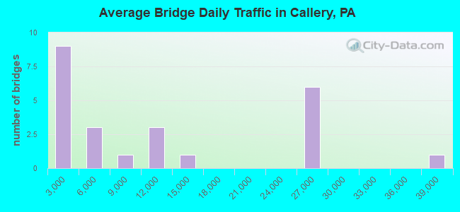
- 257,576Total average daily traffic
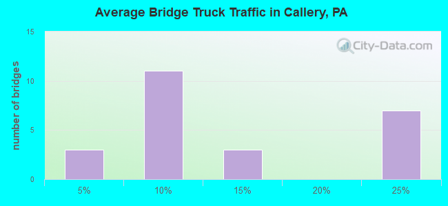
- 48,801Total average daily truck traffic
- 323,200Total future (year 2026) average daily traffic
- National Bridge Inventory (NBI) Registered Bridges for Callery
- No street view available for this location
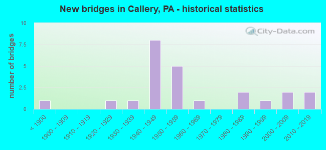
- New bridges - historical statistics
- 1Before 1900
- 11920-1929
- 11930-1939
- 81940-1949
- 51950-1959
- 11960-1969
- 21980-1989
- 11990-1999
- 22000-2009
- 22010-2019
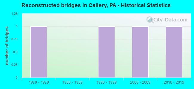
- Reconstructed bridges - Historical Statistics
- 11970-1979
- 01980-1989
- 11990-1999
- 12000-2009
- 12010-2019
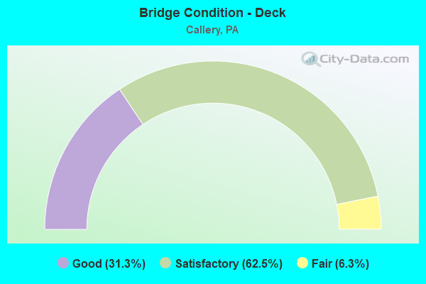
- Bridge Condition - Deck
- 31.3%Good
- 62.5%Satisfactory
- 6.3%Fair
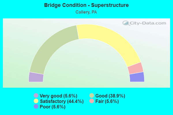
- Bridge Condition - Superstructure
- 5.6%Very good
- 38.9%Good
- 44.4%Satisfactory
- 5.6%Fair
- 5.6%Poor
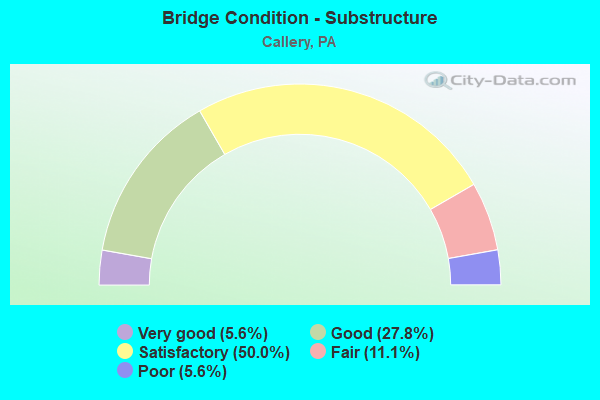
- Bridge Condition - Substructure
- 5.6%Very good
- 27.8%Good
- 50.0%Satisfactory
- 11.1%Fair
- 5.6%Poor
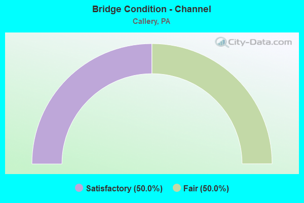
- Bridge Condition - Channel
- 50.0%Satisfactory
- 50.0%Fair
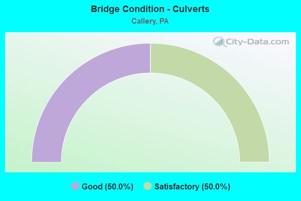
- Bridge Condition - Culverts
- 50.0%Good
- 50.0%Satisfactory
Find on map >> Show street view
Structure Number: 2178, Location: BI01 B & LE RR NO. 1 (Lat: 40.469542, Lng: -79.795342), Route carried "on" structure: County highway , Year Built: 1923, Year Reconstructed: 1981, Status: Open, Structure Length: 2.87m (9.42ft), Average Daily Traffic: 9,286 (year 2006), Truck Traffic: 5%, Average Future Daily Traffic: 9,286 (year 2026), Design Load: HS 20, Features Intersected: UNION RAILROAD, Facility Carried by Structure: UNIVERSAL RD
Minimum Vertical Clearance: 30+ m (98+ ft), Kilometerpoint: 0.000, Lanes on structure: 2, Owner: County Highway Agency, Approaching Roadway Width: 8.2m (26.9ft), Material/Design: Steel continuous, Design/Construction: Stringer/Multi-beam, Number Of Spans In Main Unit: 3, Length of Maximum Span: 12.2m (40.0ft), Curb or Sidewalk Widths: Left: 0.2m (0.7ft), Right: 1.4m (4.6ft), Curb-To-Curb Width: 8.2m (26.9ft), Out-to-Out Width: 10.8m (35.4ft)
Condition: Deck: Fair, Superstructure: Good, Substructure: Fair, Operating Rating: 57.2 metric tons, Method Used To Determine Operating Rating: Load Factor (LF), Inventory Rating: 34.5 metric tons, Method Used To Determine Inventory Rating: Load Factor (LF), Structural Evaluation: Somewhat better than minimum adequacy, Deck Geometry: High priority of replacement, Underclear: High priority of corrective action, Approach Roadway Alignment: Meets minimum limits, Length Of Structure Improvement: 2.90m (9.51ft), Designated Inspection Frequency: Every 24 months, Critical Feature Inspection Frequency: Every 24 months, Inspection Date: August 2020, Critical Feature Inspection Date: August 2020, Bridge Improvement Cost: $13,000, Roadway Improvement Cost: $53,000, Total Project Cost: $173,000, Deck Structure Type: Concrete Cast-file-Place, Wearing Surface/Protective System: Wearing Surface: Bituminous
Find on map >> Show street view
Structure Number: 8076, Location: WEST OF CALLERY (Lat: 40.736033, Lng: -80.054192), Route carried "on" structure: State highway , Year Built: 1996, Status: Open, Structure Length: 0.98m (3.22ft), Average Daily Traffic: 1,016 (year 2022), Truck Traffic: 6%, Average Future Daily Traffic: 2,021 (year 2032), Design Load: HS 25 or greater, Features Intersected: WOLFE RUN, Facility Carried by Structure: SR 3014
Minimum Vertical Clearance: 30+ m (98+ ft), Kilometerpoint: 1.495, Lanes on structure: 2, Owner: State Highway Agency, Approaching Roadway Width: 7.0m (23.0ft), Material/Design: Concrete, Design/Construction: Culvert, Number Of Spans In Main Unit: 2, Length of Maximum Span: 9.8m (32.2ft)
Condition: Channel: Fair, Culverts: Good, Operating Rating: 49.0 metric tons, Method Used To Determine Operating Rating: Field evaluation and documented engineering judgment, Inventory Rating: 32.7 metric tons, Method Used To Determine Inventory Rating: Field evaluation and documented engineering judgment, Structural Evaluation: Better than present minimum criteria, Waterway Adequacy: Superior to present desirable criteria, Approach Roadway Alignment: Equal to present desirable criteria, Length Of Structure Improvement: 1.58m (5.18ft), Designated Inspection Frequency: Every 48 months, Inspection Date: April 2020
Find on map >> Show street view
Structure Number: 8077, Location: CALLERY BORO (Lat: 40.741414, Lng: -80.034303), Route carried "on" structure: State highway , Year Built: 1933, Status: Open, Structure Length: 1.22m (4.00ft), Average Daily Traffic: 1,016 (year 2022), Truck Traffic: 6%, Average Future Daily Traffic: 2,021 (year 2032), Design Load: H 20, Features Intersected: BREAKNECK CREEK, Facility Carried by Structure: SR3014
Minimum Vertical Clearance: 30+ m (98+ ft), Kilometerpoint: 3.199, Lanes on structure: 2, Owner: State Highway Agency, Approaching Roadway Width: 6.4m (21.0ft), Material/Design: Concrete, Design/Construction: Arch - Deck, Number Of Spans In Main Unit: 1, Length of Maximum Span: 12.2m (40.0ft), Curb-To-Curb Width: 5.1m (16.7ft), Out-to-Out Width: 6.2m (20.3ft)
Condition: Superstructure: Poor, Substructure: Poor, Channel: Satisfactory, Operating Rating: 49.0 metric tons, Method Used To Determine Operating Rating: Field evaluation and documented engineering judgment, Inventory Rating: 32.7 metric tons, Method Used To Determine Inventory Rating: Field evaluation and documented engineering judgment, Structural Evaluation: Meets minimum limits, Deck Geometry: High priority of replacement, Waterway Adequacy: Better than present minimum criteria, Approach Roadway Alignment: Equal to present desirable criteria, Length Of Structure Improvement: 4.60m (15.09ft), Designated Inspection Frequency: Every 24 months, Inspection Date: April 2020, Bridge Improvement Cost: $44,000, Roadway Improvement Cost: $130,000, Total Project Cost: $595,000, Deck Structure Type: Concrete Cast-file-Place
Find on map >> Show street view
Structure Number: 8315, Location: 0.2 MI SW OF SR 3015 INT (Lat: 40.736692, Lng: -80.033950), Route carried "on" structure: City street , Year Built: 1988, Status: Open, Structure Length: 2.35m (7.71ft), Average Daily Traffic: 685 (year 2015), Truck Traffic: 9%, Average Future Daily Traffic: 700 (year 2035), Design Load: HS 25 or greater, Features Intersected: BREAKNECK CREEK, Facility Carried by Structure: CENTER STREET
Minimum Vertical Clearance: 30+ m (98+ ft), Kilometerpoint: 0.000, Lanes on structure: 2, Owner: County Highway Agency, Approaching Roadway Width: 9.1m (29.9ft), Skew: 4 degrees, Material/Design: Prestressed concrete, Design/Construction: Box Beam or Girders - Single/Spread, Number Of Spans In Main Unit: 1, Length of Maximum Span: 22.6m (74.1ft), Curb or Sidewalk Widths: Left: 0.2m (0.7ft), Right: 0.2m (0.7ft), Curb-To-Curb Width: 9.1m (29.9ft), Out-to-Out Width: 9.9m (32.5ft)
Condition: Deck: Satisfactory, Superstructure: Good, Substructure: Good, Channel: Satisfactory, Operating Rating: 66.2 metric tons, Method Used To Determine Operating Rating: Load Factor (LF), Inventory Rating: 22.7 metric tons, Method Used To Determine Inventory Rating: Load Factor (LF), Structural Evaluation: Equal to present minimum criteria, Deck Geometry: Equal to present minimum criteria, Waterway Adequacy: Equal to present desirable criteria, Approach Roadway Alignment: Equal to present minimum criteria, Length Of Structure Improvement: 2.90m (9.51ft), Designated Inspection Frequency: Every 24 months, Inspection Date: October 2021, Deck Structure Type: Concrete Cast-file-Place, Wearing Surface/Protective System: Wearing Surface: Monolithic Concrete, Deck Protection: Epoxy Coated Reinforcing
Find on map >> Show street view
Structure Number: 9903, Location: NEAR AVONDALE 46D04 (Lat: 39.844889, Lng: -75.789972), Route carried "on" structure: US 1, Year Built: 1965, Year Reconstructed: 1998, Status: Open, Structure Length: 1.01m (3.31ft), Average Daily Traffic: 10,023 (year 2020), Truck Traffic: 5%, Average Future Daily Traffic: 17,790 (year 2032), Design Load: HS 20, Features Intersected: W FRK E BR WHITE CLAY CR
Minimum Vertical Clearance: 30+ m (98+ ft), Kilometerpoint: 27.311, Lanes on structure: 2, Base Highway Network: Yes, Owner: State Highway Agency, Approaching Roadway Width: 12.2m (40.0ft), Skew: 11 degrees, Material/Design: Prestressed concrete, Design/Construction: Box Beam or Girders - Single/Spread, Number Of Spans In Main Unit: 1, Length of Maximum Span: 9.8m (32.2ft), Curb or Sidewalk Widths: Left: 0.5m (1.6ft), Right: 0.5m (1.6ft), Curb-To-Curb Width: 12.2m (40.0ft), Out-to-Out Width: 13.9m (45.6ft)
Condition: Deck: Satisfactory, Superstructure: Good, Substructure: Satisfactory, Channel: Fair, Operating Rating: 58.1 metric tons, Method Used To Determine Operating Rating: Load Factor (LF), Inventory Rating: 30.8 metric tons, Method Used To Determine Inventory Rating: Load Factor (LF), Structural Evaluation: Equal to present minimum criteria, Deck Geometry: Better than present minimum criteria, Waterway Adequacy: Superior to present desirable criteria, Approach Roadway Alignment: Equal to present desirable criteria, Length Of Structure Improvement: 1.60m (5.25ft), Designated Inspection Frequency: Every 24 months, Inspection Date: June 2020, Bridge Improvement Cost: $5,000, Roadway Improvement Cost: $15,000, Total Project Cost: $68,000, Deck Structure Type: Concrete Cast-file-Place, Wearing Surface/Protective System: Wearing Surface: Monolithic Concrete
Find on map >> Show street view
Structure Number: 10086, Location: COPES BRIDGE 31D11 (Lat: 39.958825, Lng: -75.655375), Route carried "on" structure: State highway 162, Year Built: 1807, Year Reconstructed: 2010, Status: Open, Structure Length: 4.69m (15.39ft), Average Daily Traffic: 5,168 (year 2020), Truck Traffic: 7%, Average Future Daily Traffic: 7,924 (year 2032), Design Load: HS 25 or greater, Features Intersected: EAST BR.BRANDYWINE CREEK, Facility Carried by Structure: STRASBURG ROAD
Minimum Vertical Clearance: 30+ m (98+ ft), Kilometerpoint: 12.701, Lanes on structure: 2, Owner: State Highway Agency, Approaching Roadway Width: 6.4m (21.0ft), Material/Design: Masonry, Design/Construction: Arch - Deck, Number Of Spans In Main Unit: 3, Length of Maximum Span: 20.1m (65.9ft), Curb-To-Curb Width: 6.1m (20.0ft), Out-to-Out Width: 7.6m (24.9ft)
Condition: Superstructure: Satisfactory, Substructure: Satisfactory, Channel: Fair, Operating Rating: 47.2 metric tons, Method Used To Determine Operating Rating: Assigned rating based on Load Factor Design (LFD) reported in metric tons, Inventory Rating: 39.0 metric tons, Method Used To Determine Inventory Rating: Assigned rating based on Load Factor Design (LFD) reported in metric tons, Structural Evaluation: Equal to present minimum criteria, Deck Geometry: High priority of replacement, Waterway Adequacy: Equal to present desirable criteria, Approach Roadway Alignment: High priority of corrective action, Length Of Structure Improvement: 4.60m (15.09ft), Designated Inspection Frequency: Every 24 months, Inspection Date: April 2021, Bridge Improvement Cost: $38,000, Roadway Improvement Cost: $113,000, Total Project Cost: $516,000, Deck Structure Type: Concrete Cast-file-Place, Wearing Surface/Protective System: Wearing Surface: Bituminous, Membrane: Other, Deck Protection: Epoxy Coated Reinforcing
Find on map >> Show street view
Structure Number: 21762, Location: 2MI N ELSTONVILLE (Lat: 40.228322, Lng: -76.453383), Route carried "on" structure: State highway , Year Built: 1950, Status: Open, Structure Length: 2.68m (8.79ft), Average Daily Traffic: 1,597 (year 2021), Truck Traffic: 7%, Average Future Daily Traffic: 1,703 (year 2030), Design Load: HS 20, Features Intersected: PA TPK (I-76), Facility Carried by Structure: SR 4029, LR 36174
Minimum Vertical Clearance: 30+ m (98+ ft), Kilometerpoint: 1.337, Lanes on structure: 2, Lanes under structure: 4, Owner: State Toll Authority, Approaching Roadway Width: 7.3m (24.0ft), Skew: 1 degrees, Material/Design: Concrete, Design/Construction: Frame, Number Of Spans In Main Unit: 1, Length of Maximum Span: 25.0m (82.0ft), Curb or Sidewalk Widths: Left: 0.2m (0.7ft), Right: 0.2m (0.7ft), Curb-To-Curb Width: 7.3m (24.0ft), Out-to-Out Width: 8.2m (26.9ft)
Condition: Deck: Good, Superstructure: Good, Substructure: Good, Operating Rating: 58.1 metric tons, Method Used To Determine Operating Rating: Field evaluation and documented engineering judgment, Inventory Rating: 34.5 metric tons, Method Used To Determine Inventory Rating: Field evaluation and documented engineering judgment, Structural Evaluation: Better than present minimum criteria, Deck Geometry: Meets minimum limits, Underclear: Meets minimum limits, Approach Roadway Alignment: Equal to present desirable criteria, Length Of Structure Improvement: 3.40m (11.15ft), Designated Inspection Frequency: Every 24 months, Inspection Date: March 2021
Find on map >> Show street view
Structure Number: 21764, Location: N ELSTONVILLE (Lat: 40.229500, Lng: -76.432994), Route carried "on" structure: State highway 72, Year Built: 1950, Year Reconstructed: 2012, Status: Open, Structure Length: 3.11m (10.20ft), Average Daily Traffic: 13,249 (year 2021), Truck Traffic: 10%, Average Future Daily Traffic: 17,682 (year 2030), Design Load: HS 20, Features Intersected: PA TPK (I-76)
Minimum Vertical Clearance: 30+ m (98+ ft), Kilometerpoint: 26.219, Lanes on structure: 2, Lanes under structure: 5, Base Highway Network: Yes, Owner: State Toll Authority, Approaching Roadway Width: 10.7m (35.1ft), Skew: 2 degrees, Material/Design: Steel, Design/Construction: Girder and Floorbeam System, Number Of Spans In Main Unit: 1, Length of Maximum Span: 29.9m (98.1ft), Curb-To-Curb Width: 11.6m (38.1ft), Out-to-Out Width: 13.7m (44.9ft)
Condition: Deck: Good, Superstructure: Satisfactory, Substructure: Satisfactory, Operating Rating: 86.2 metric tons, Method Used To Determine Operating Rating: Load Factor (LF), Inventory Rating: 51.7 metric tons, Method Used To Determine Inventory Rating: Load Factor (LF), Structural Evaluation: Equal to present minimum criteria, Deck Geometry: Somewhat better than minimum adequacy, Underclear: Meets minimum limits, Approach Roadway Alignment: Equal to present desirable criteria, Length Of Structure Improvement: 3.90m (12.80ft), Designated Inspection Frequency: Every 24 months, Critical Feature Inspection Frequency: Every 24 months, Inspection Date: March 2021, Critical Feature Inspection Date: March 2021, Deck Structure Type: Concrete Cast-file-Place, Wearing Surface/Protective System: Wearing Surface: Monolithic Concrete, Deck Protection: Epoxy Coated Reinforcing
Find on map >> Show street view
Structure Number: 21765, Location: PENN TWP (Lat: 40.229172, Lng: -76.427017), Route carried "on" structure: Interstate 76, Year Built: 1949, Status: Open, Structure Length: 1.01m (3.31ft), Average Daily Traffic: 24,971 (year 2001), Truck Traffic: 24%, Average Future Daily Traffic: 32,334 (year 2030), Design Load: HS 20, Features Intersected: SHEARERS CREEK
Minimum Vertical Clearance: 30+ m (98+ ft), Kilometerpoint: 0.000, Lanes on structure: 4, Base Highway Network: Yes, Toll: On toll road, Owner: State Toll Authority, Approaching Roadway Width: 23.8m (78.1ft), Skew: 34 degrees, Material/Design: Concrete, Design/Construction: Culvert, Number Of Spans In Main Unit: 1, Length of Maximum Span: 8.2m (26.9ft)
Condition: Channel: Fair, Culverts: Satisfactory, Operating Rating: 89.8 metric tons, Method Used To Determine Operating Rating: Load Factor (LF), Inventory Rating: 89.8 metric tons, Method Used To Determine Inventory Rating: Load Factor (LF), Structural Evaluation: Equal to present minimum criteria, Waterway Adequacy: Superior to present desirable criteria, Approach Roadway Alignment: Equal to present desirable criteria, Length Of Structure Improvement: 1.60m (5.25ft), Designated Inspection Frequency: Every 48 months, Inspection Date: April 2019
Find on map >> Show street view
Structure Number: 21768, Location: ELIZABETH TWP (Lat: 40.232681, Lng: -76.325189), Route carried "on" structure: US 322, Year Built: 1949, Status: Open, Structure Length: 4.66m (15.29ft), Average Daily Traffic: 8,003 (year 2022), Truck Traffic: 5%, Average Future Daily Traffic: 8,742 (year 2030), Design Load: HL 93, Features Intersected: PA TPK (I-76)
Minimum Vertical Clearance: 30+ m (98+ ft), Kilometerpoint: 4.348, Lanes on structure: 2, Lanes under structure: 4, Base Highway Network: Yes, Owner: State Toll Authority, Approaching Roadway Width: 11.6m (38.1ft), Skew: 5 degrees, Material/Design: Steel, Design/Construction: Girder and Floorbeam System, Number Of Spans In Main Unit: 1, Length of Maximum Span: 44.2m (145.0ft), Curb-To-Curb Width: 11.6m (38.1ft), Out-to-Out Width: 13.7m (44.9ft)
Condition: Deck: Satisfactory, Superstructure: Fair, Substructure: Fair, Operating Rating: 48.1 metric tons, Method Used To Determine Operating Rating: Load Factor (LF), Inventory Rating: 29.0 metric tons, Method Used To Determine Inventory Rating: Load Factor (LF), Structural Evaluation: Somewhat better than minimum adequacy, Deck Geometry: Somewhat better than minimum adequacy, Underclear: High priority of replacement, Approach Roadway Alignment: Equal to present desirable criteria, Length Of Structure Improvement: 5.50m (18.04ft), Designated Inspection Frequency: Every 24 months, Critical Feature Inspection Frequency: Every 24 months, Inspection Date: April 2021, Critical Feature Inspection Date: April 2021, Bridge Improvement Cost: $83,000, Roadway Improvement Cost: $243,000, Total Project Cost: $1,115,000, Deck Structure Type: Concrete Cast-file-Place, Wearing Surface/Protective System: Wearing Surface: Monolithic Concrete
Find on map >> Show street view
Structure Number: 21769, Location: N BRICKERVILLE (Lat: 40.235139, Lng: -76.300550), Route carried "on" structure: State highway 501, Year Built: 1949, Status: Open, Structure Length: 2.68m (8.79ft), Average Daily Traffic: 9,204 (year 2021), Truck Traffic: 11%, Average Future Daily Traffic: 8,190 (year 2030), Design Load: HS 20, Features Intersected: PA TPK (I-76)
Minimum Vertical Clearance: 30+ m (98+ ft), Kilometerpoint: 19.991, Lanes on structure: 2, Lanes under structure: 4, Base Highway Network: Yes, Owner: State Toll Authority, Approaching Roadway Width: 11.6m (38.1ft), Skew: 1 degrees, Material/Design: Concrete, Design/Construction: Frame, Number Of Spans In Main Unit: 1, Length of Maximum Span: 23.8m (78.1ft), Curb or Sidewalk Widths: Left: 0.2m (0.7ft), Right: 0.2m (0.7ft), Curb-To-Curb Width: 11.6m (38.1ft), Out-to-Out Width: 12.6m (41.3ft)
Condition: Deck: Satisfactory, Superstructure: Satisfactory, Substructure: Satisfactory, Operating Rating: 70.8 metric tons, Method Used To Determine Operating Rating: Field evaluation and documented engineering judgment, Inventory Rating: 42.6 metric tons, Method Used To Determine Inventory Rating: Field evaluation and documented engineering judgment, Structural Evaluation: Equal to present minimum criteria, Deck Geometry: Somewhat better than minimum adequacy, Underclear: Meets minimum limits, Approach Roadway Alignment: Equal to present desirable criteria, Length Of Structure Improvement: 3.40m (11.15ft), Designated Inspection Frequency: Every 24 months, Inspection Date: April 2021, Wearing Surface/Protective System: Wearing Surface: Bituminous
Find on map >> Show street view
Structure Number: 2177, Location: ELIZABETH TWP (Lat: 40.235200, Lng: -76.294767), Route carried "on" structure: Interstate 76, Year Built: 1949, Status: Open, Structure Length: 1.04m (3.41ft), Average Daily Traffic: 24,971 (year 2001), Truck Traffic: 24%, Average Future Daily Traffic: 32,334 (year 2030), Design Load: HS 20, Features Intersected: FURNACE RUN
Minimum Vertical Clearance: 30+ m (98+ ft), Kilometerpoint: 0.000, Lanes on structure: 4, Base Highway Network: Yes, Toll: On toll road, Owner: State Toll Authority, Approaching Roadway Width: 23.8m (78.1ft), Skew: 31 degrees, Material/Design: Concrete, Design/Construction: Culvert, Number Of Spans In Main Unit: 1, Length of Maximum Span: 6.1m (20.0ft)
Condition: Channel: Fair, Culverts: Satisfactory, Operating Rating: 89.8 metric tons, Method Used To Determine Operating Rating: Load Factor (LF), Inventory Rating: 89.8 metric tons, Method Used To Determine Inventory Rating: Load Factor (LF), Structural Evaluation: Equal to present minimum criteria, Waterway Adequacy: Superior to present desirable criteria, Approach Roadway Alignment: Equal to present desirable criteria, Length Of Structure Improvement: 1.70m (5.58ft), Designated Inspection Frequency: Every 48 months, Inspection Date: March 2019
Find on map >> Show street view
Structure Number: 21771, Location: CLAY TWP (Lat: 40.236089, Lng: -76.282028), Route carried "on" structure: Interstate 76, Year Built: 1949, Status: Open, Structure Length: 0.79m (2.59ft), Average Daily Traffic: 24,971 (year 2001), Truck Traffic: 24%, Average Future Daily Traffic: 32,334 (year 2030), Design Load: HS 20, Features Intersected: SEGLOCH RUN
Minimum Vertical Clearance: 30+ m (98+ ft), Kilometerpoint: 0.000, Lanes on structure: 4, Base Highway Network: Yes, Toll: On toll road, Owner: State Toll Authority, Approaching Roadway Width: 23.8m (78.1ft), Skew: 31 degrees, Material/Design: Concrete, Design/Construction: Culvert, Number Of Spans In Main Unit: 1, Length of Maximum Span: 6.4m (21.0ft)
Condition: Channel: Fair, Culverts: Good, Operating Rating: 89.8 metric tons, Method Used To Determine Operating Rating: Load Factor (LF), Inventory Rating: 89.8 metric tons, Method Used To Determine Inventory Rating: Load Factor (LF), Structural Evaluation: Better than present minimum criteria, Waterway Adequacy: Superior to present desirable criteria, Approach Roadway Alignment: Equal to present desirable criteria, Length Of Structure Improvement: 1.40m (4.59ft), Designated Inspection Frequency: Every 48 months, Inspection Date: March 2019
Find on map >> Show street view
Structure Number: 21774, Location: I ML N.HOPELAND (Lat: 40.240725, Lng: -76.251542), Route carried "on" structure: Interstate 76, Year Built: 1950, Status: Open, Structure Length: 0.94m (3.08ft), Average Daily Traffic: 24,971 (year 2001), Truck Traffic: 24%, Average Future Daily Traffic: 32,334 (year 2030), Design Load: HS 20, Features Intersected: MIDDLE CREEK
Minimum Vertical Clearance: 30+ m (98+ ft), Kilometerpoint: 0.000, Lanes on structure: 4, Base Highway Network: Yes, Toll: On toll road, Owner: State Toll Authority, Approaching Roadway Width: 25.0m (82.0ft), Skew: 34 degrees, Material/Design: Concrete, Design/Construction: Slab, Number Of Spans In Main Unit: 1, Length of Maximum Span: 7.9m (25.9ft), Curb or Sidewalk Widths: Left: 0.2m (0.7ft), Right: 0.2m (0.7ft), Curb-To-Curb Width: 20.7m (67.9ft), Out-to-Out Width: 22.4m (73.5ft)
Condition: Deck: Satisfactory, Superstructure: Satisfactory, Substructure: Satisfactory, Channel: Satisfactory, Operating Rating: 58.1 metric tons, Method Used To Determine Operating Rating: Load Factor (LF), Inventory Rating: 34.5 metric tons, Method Used To Determine Inventory Rating: Load Factor (LF), Structural Evaluation: Equal to present minimum criteria, Deck Geometry: Equal to present minimum criteria, Waterway Adequacy: Equal to present desirable criteria, Approach Roadway Alignment: Equal to present desirable criteria, Length Of Structure Improvement: 1.60m (5.25ft), Designated Inspection Frequency: Every 24 months, Inspection Date: April 2021, Bridge Improvement Cost: $16,000, Roadway Improvement Cost: $48,000, Total Project Cost: $219,000, Wearing Surface/Protective System: Wearing Surface: Latex Concrete
Find on map >> Show street view
Structure Number: 21775, Location: 05 MILE N OF NEWTOWN (Lat: 40.241000, Lng: -76.249472), Route carried "on" structure: State highway , Year Built: 1950, Status: Open, Structure Length: 2.90m (9.51ft), Average Daily Traffic: 1,325 (year 2021), Truck Traffic: 10%, Average Future Daily Traffic: 1,563 (year 2030), Design Load: HS 20, Features Intersected: PA TPK (I-76), Facility Carried by Structure: SR 1035, LR 36011
Minimum Vertical Clearance: 30+ m (98+ ft), Kilometerpoint: 5.856, Lanes on structure: 2, Lanes under structure: 4, Owner: State Toll Authority, Approaching Roadway Width: 7.9m (25.9ft), Skew: 2 degrees, Material/Design: Concrete, Design/Construction: Frame, Number Of Spans In Main Unit: 1, Length of Maximum Span: 25.6m (84.0ft), Curb or Sidewalk Widths: Left: 0.2m (0.7ft), Right: 0.2m (0.7ft), Curb-To-Curb Width: 8.5m (27.9ft), Out-to-Out Width: 9.4m (30.8ft)
Condition: Deck: Satisfactory, Superstructure: Satisfactory, Substructure: Satisfactory, Operating Rating: 55.3 metric tons, Method Used To Determine Operating Rating: Field evaluation and documented engineering judgment, Inventory Rating: 32.7 metric tons, Method Used To Determine Inventory Rating: Field evaluation and documented engineering judgment, Structural Evaluation: Equal to present minimum criteria, Deck Geometry: Somewhat better than minimum adequacy, Underclear: High priority of corrective action, Approach Roadway Alignment: Equal to present desirable criteria, Length Of Structure Improvement: 3.70m (12.14ft), Designated Inspection Frequency: Every 24 months, Inspection Date: April 2021, Bridge Improvement Cost: $16,000, Roadway Improvement Cost: $48,000, Total Project Cost: $219,000, Wearing Surface/Protective System: Wearing Surface: Monolithic Concrete
Find on map >> Show street view
Structure Number: 21776, Location: CLAY TWP (Lat: 40.241708, Lng: -76.246486), Route carried "on" structure: Interstate 76, Year Built: 1948, Status: Open, Structure Length: 1.34m (4.40ft), Average Daily Traffic: 24,971 (year 2001), Truck Traffic: 24%, Average Future Daily Traffic: 32,334 (year 2030), Design Load: HS 20, Features Intersected: MIDDLE CREEK
Minimum Vertical Clearance: 30+ m (98+ ft), Kilometerpoint: 0.000, Lanes on structure: 4, Base Highway Network: Yes, Toll: On toll road, Owner: State Toll Authority, Approaching Roadway Width: 17.7m (58.1ft), Skew: 31 degrees, Material/Design: Concrete, Design/Construction: Culvert, Number Of Spans In Main Unit: 1, Length of Maximum Span: 12.2m (40.0ft)
Condition: Channel: Satisfactory, Culverts: Satisfactory, Operating Rating: 89.8 metric tons, Method Used To Determine Operating Rating: Load Factor (LF), Inventory Rating: 89.8 metric tons, Method Used To Determine Inventory Rating: Load Factor (LF), Structural Evaluation: Equal to present minimum criteria, Waterway Adequacy: Superior to present desirable criteria, Approach Roadway Alignment: Equal to present desirable criteria, Length Of Structure Improvement: 2.00m (6.56ft), Designated Inspection Frequency: Every 48 months, Inspection Date: March 2019
Find on map >> Show street view
Structure Number: 21777, Location: N MT AIRY (Lat: 40.243689, Lng: -76.234406), Route carried "on" structure: State highway , Year Built: 1950, Status: Open, Structure Length: 3.08m (10.10ft), Average Daily Traffic: 330 (year 1992), Truck Traffic: 6%, Average Future Daily Traffic: 520 (year 2030), Design Load: HS 20, Features Intersected: PA TPK (I-76), Facility Carried by Structure: SR 1052, LR 36170
Minimum Vertical Clearance: 30+ m (98+ ft), Kilometerpoint: 0.000, Lanes on structure: 2, Lanes under structure: 4, Owner: State Toll Authority, Approaching Roadway Width: 7.3m (24.0ft), Skew: 6 degrees, Material/Design: Concrete, Design/Construction: Frame, Number Of Spans In Main Unit: 1, Length of Maximum Span: 27.4m (89.9ft), Curb or Sidewalk Widths: Left: 0.2m (0.7ft), Right: 0.2m (0.7ft), Curb-To-Curb Width: 7.3m (24.0ft), Out-to-Out Width: 8.2m (26.9ft)
Condition: Deck: Satisfactory, Superstructure: Satisfactory, Substructure: Satisfactory, Operating Rating: 54.4 metric tons, Method Used To Determine Operating Rating: Field evaluation and documented engineering judgment, Inventory Rating: 32.7 metric tons, Method Used To Determine Inventory Rating: Field evaluation and documented engineering judgment, Structural Evaluation: Equal to present minimum criteria, Deck Geometry: Somewhat better than minimum adequacy, Underclear: Meets minimum limits, Approach Roadway Alignment: Equal to present desirable criteria, Length Of Structure Improvement: 3.10m (10.17ft), Designated Inspection Frequency: Every 24 months, Inspection Date: April 2021, Bridge Improvement Cost: $15,000, Roadway Improvement Cost: $43,000, Total Project Cost: $199,000, Wearing Surface/Protective System: Wearing Surface: Bituminous
Find on map >> Show street view
Structure Number: 21778, Location: CLAY TWP (Lat: 40.244778, Lng: -76.227564), Route carried "on" structure: City street , Year Built: 1949, Status: Open, Structure Length: 2.65m (8.69ft), Average Daily Traffic: 200 (year 1992), Truck Traffic: 6%, Average Future Daily Traffic: 315 (year 2030), Design Load: HS 20, Features Intersected: PA TPK (I-76), Facility Carried by Structure: T-646
Minimum Vertical Clearance: 30+ m (98+ ft), Kilometerpoint: 0.000, Lanes on structure: 2, Lanes under structure: 4, Owner: State Toll Authority, Approaching Roadway Width: 6.7m (22.0ft), Material/Design: Concrete, Design/Construction: Frame, Number Of Spans In Main Unit: 1, Length of Maximum Span: 23.8m (78.1ft), Curb or Sidewalk Widths: Left: 0.2m (0.7ft), Right: 0.2m (0.7ft), Curb-To-Curb Width: 6.1m (20.0ft), Out-to-Out Width: 7.1m (23.3ft)
Condition: Deck: Satisfactory, Superstructure: Satisfactory, Substructure: Satisfactory, Operating Rating: 65.3 metric tons, Method Used To Determine Operating Rating: Load Factor (LF), Inventory Rating: 39.0 metric tons, Method Used To Determine Inventory Rating: Load Factor (LF), Structural Evaluation: Equal to present minimum criteria, Deck Geometry: Meets minimum limits, Underclear: Meets minimum limits, Approach Roadway Alignment: Equal to present desirable criteria, Length Of Structure Improvement: 3.40m (11.15ft), Designated Inspection Frequency: Every 24 months, Inspection Date: April 2021, Bridge Improvement Cost: $6,000, Roadway Improvement Cost: $17,000, Total Project Cost: $78,000, Wearing Surface/Protective System: Wearing Surface: Bituminous
Find on map >> Show street view
Structure Number: 21779, Location: CLAY TWP (Lat: 40.245969, Lng: -76.215653), Route carried "on" structure: Interstate 76, Year Built: 1949, Status: Open, Structure Length: 0.82m (2.69ft), Average Daily Traffic: 24,971 (year 2001), Truck Traffic: 24%, Average Future Daily Traffic: 32,334 (year 2030), Design Load: HS 20, Features Intersected: T-648
Minimum Vertical Clearance: 30+ m (98+ ft), Kilometerpoint: 0.000, Lanes on structure: 4, Lanes under structure: 2, Base Highway Network: Yes, Toll: On toll road, Owner: State Toll Authority, Approaching Roadway Width: 23.8m (78.1ft), Skew: 31 degrees, Material/Design: Concrete, Design/Construction: Tee Beam, Number Of Spans In Main Unit: 1, Length of Maximum Span: 6.7m (22.0ft), Curb or Sidewalk Widths: Left: 0.2m (0.7ft), Right: 0.2m (0.7ft), Curb-To-Curb Width: 20.7m (67.9ft), Out-to-Out Width: 22.3m (73.2ft)
Condition: Deck: Satisfactory, Superstructure: Satisfactory, Substructure: Satisfactory, Operating Rating: 68.0 metric tons, Method Used To Determine Operating Rating: Load Factor (LF), Inventory Rating: 40.8 metric tons, Method Used To Determine Inventory Rating: Load Factor (LF), Structural Evaluation: Equal to present minimum criteria, Deck Geometry: Equal to present minimum criteria, Underclear: High priority of corrective action, Approach Roadway Alignment: Equal to present desirable criteria, Length Of Structure Improvement: 1.40m (4.59ft), Designated Inspection Frequency: Every 48 months, Inspection Date: April 2019, Bridge Improvement Cost: $8,000, Roadway Improvement Cost: $22,000, Total Project Cost: $103,000, Deck Structure Type: Concrete Cast-file-Place, Wearing Surface/Protective System: Wearing Surface: Latex Concrete
Find on map >> Show street view
Structure Number: 28529, Location: I-78 OVER SO.MT.DRIVE (Lat: 40.591203, Lng: -75.368578), Route carried "on" structure: Interstate 78, Year Built: 1988, Status: Open, Structure Length: 3.69m (12.11ft), Average Daily Traffic: 36,659 (year 2021), Truck Traffic: 22%, Average Future Daily Traffic: 39,527 (year 2032), Design Load: HS 25 or greater, Features Intersected: SO.MT.DRIVE(T-422)
Minimum Vertical Clearance: 30+ m (98+ ft), Kilometerpoint: 2.427, Lanes on structure: 2, Lanes under structure: 2, Base Highway Network: Yes, Owner: State Highway Agency, Approaching Roadway Width: 13.4m (44.0ft), Skew: 11 degrees, Material/Design: Prestressed concrete, Design/Construction: Box Beam or Girders - Single/Spread, Number Of Spans In Main Unit: 3, Length of Maximum Span: 17.7m (58.1ft), Curb or Sidewalk Widths: Left: 0.2m (0.7ft), Right: 0.2m (0.7ft), Curb-To-Curb Width: 13.4m (44.0ft), Out-to-Out Width: 14.5m (47.6ft)
Condition: Deck: Good, Superstructure: Good, Substructure: Good, Operating Rating: 60.8 metric tons, Method Used To Determine Operating Rating: Load Factor (LF), Inventory Rating: 36.3 metric tons, Method Used To Determine Inventory Rating: Load Factor (LF), Structural Evaluation: Better than present minimum criteria, Deck Geometry: Superior to present desirable criteria, Underclear: Equal to present minimum criteria, Approach Roadway Alignment: Equal to present desirable criteria, Length Of Structure Improvement: 4.60m (15.09ft), Designated Inspection Frequency: Every 24 months, Inspection Date: January 2020, Deck Structure Type: Concrete Cast-file-Place, Wearing Surface/Protective System: Wearing Surface: Monolithic Concrete, Deck Protection: Epoxy Coated Reinforcing
Find on map >> Show street view
Structure Number: 42745, Location: KROCHTA BRIDGE (Lat: 40.727553, Lng: -80.072453), Route carried "on" structure: State highway , Year Built: 2004, Status: Open, Structure Length: 1.04m (3.41ft), Average Daily Traffic: 4,639 (year 2022), Truck Traffic: 1%, Average Future Daily Traffic: 3,460 (year 2032), Design Load: H 20, Features Intersected: WOLFE RUN, Facility Carried by Structure: SR3021
Minimum Vertical Clearance: 30+ m (98+ ft), Kilometerpoint: 6.555, Lanes on structure: 2, Owner: State Highway Agency, Approaching Roadway Width: 11.0m (36.1ft), Material/Design: Concrete, Design/Construction: Culvert, Number Of Spans In Main Unit: 1, Length of Maximum Span: 9.8m (32.2ft), Curb or Sidewalk Widths: Left: 0.2m (0.7ft), Right: 0.2m (0.7ft), Curb-To-Curb Width: 11.3m (37.1ft), Out-to-Out Width: 12.2m (40.0ft)
Condition: Channel: Satisfactory, Culverts: Good, Operating Rating: 68.0 metric tons, Method Used To Determine Operating Rating: Load Factor (LF), Inventory Rating: 41.7 metric tons, Method Used To Determine Inventory Rating: Load Factor (LF), Structural Evaluation: Better than present minimum criteria, Deck Geometry: Somewhat better than minimum adequacy, Waterway Adequacy: Better than present minimum criteria, Approach Roadway Alignment: Equal to present desirable criteria, Length Of Structure Improvement: 1.70m (5.58ft), Designated Inspection Frequency: Every 48 months, Inspection Date: Febuary 2020
Find on map >> Show street view
Structure Number: 45582, Location: 0.25 MI SW OF T-388 (Lat: 40.758019, Lng: -79.991864), Route carried "on" structure: City street , Year Built: 2009, Status: Open, Structure Length: 1.92m (6.30ft), Average Daily Traffic: 100 (year 2015), Truck Traffic: 9%, Average Future Daily Traffic: 125 (year 2035), Design Load: HL 93, Features Intersected: GLADE RUN, Facility Carried by Structure: T-423 JOHNS SCHOOL
Minimum Vertical Clearance: 30+ m (98+ ft), Kilometerpoint: 0.000, Lanes on structure: 2, Owner: County Highway Agency, Approaching Roadway Width: 6.1m (20.0ft), Material/Design: Steel, Design/Construction: Stringer/Multi-beam, Number Of Spans In Main Unit: 1, Length of Maximum Span: 18.3m (60.0ft), Curb or Sidewalk Widths: Left: 0.1m (0.3ft), Right: 0.1m (0.3ft), Curb-To-Curb Width: 6.6m (21.7ft), Out-to-Out Width: 6.9m (22.6ft)
Condition: Deck: Good, Superstructure: Good, Substructure: Good, Channel: Satisfactory, Inventory Rating: 88.0 metric tons, Method Used To Determine Inventory Rating: Load and Resistance Factor (LRFR), Structural Evaluation: Better than present minimum criteria, Deck Geometry: Somewhat better than minimum adequacy, Waterway Adequacy: Better than present minimum criteria, Approach Roadway Alignment: Somewhat better than minimum adequacy, Designated Inspection Frequency: Every 24 months, Inspection Date: November 2019, Deck Structure Type: Concrete Cast-file-Place, Wearing Surface/Protective System: Wearing Surface: Monolithic Concrete, Deck Protection: Epoxy Coated Reinforcing
Find on map >> Show street view
Structure Number: 46602, Location: .3 mi. N. SR 3014 Inter. (Lat: 40.743933, Lng: -80.040964), Route carried "on" structure: City street 7402, Year Built: 2011, Status: Open, Structure Length: 0.82m (2.69ft), Average Daily Traffic: 100 (year 2015), Truck Traffic: 1%, Average Future Daily Traffic: 140 (year 2035), Design Load: HS 20, Features Intersected: WOLFE RUN, Facility Carried by Structure: MAIN STREET EXT
Minimum Vertical Clearance: 30+ m (98+ ft), Kilometerpoint: 0.000, Lanes on structure: 2, Owner: County Highway Agency, Approaching Roadway Width: 6.4m (21.0ft), Material/Design: Steel, Design/Construction: Stringer/Multi-beam, Number Of Spans In Main Unit: 1, Length of Maximum Span: 7.3m (24.0ft), Curb or Sidewalk Widths: Left: 0.1m (0.3ft), Right: 0.1m (0.3ft), Curb-To-Curb Width: 7.4m (24.3ft), Out-to-Out Width: 7.7m (25.3ft)
Condition: Deck: Satisfactory, Superstructure: Good, Substructure: Good, Channel: Satisfactory, Inventory Rating: 99.8 metric tons, Method Used To Determine Inventory Rating: Assigned ratings based on Load and Resistance Factor Design (LRFD) reported in metric tons, Structural Evaluation: Better than present minimum criteria, Deck Geometry: Equal to present minimum criteria, Waterway Adequacy: Better than present minimum criteria, Approach Roadway Alignment: Equal to present desirable criteria, Designated Inspection Frequency: Every 24 months, Inspection Date: July 2021, Deck Structure Type: Concrete Cast-file-Place, Wearing Surface/Protective System: Wearing Surface: Monolithic Concrete, Deck Protection: Epoxy Coated Reinforcing
Find on map >> Show street view
Structure Number: 4881, Location: 0.2Mi W SR 3015 Inter. (Lat: 40.729056, Lng: -80.028444), Route carried "on" structure: State highway , Year Built: 2014, Status: Open, Structure Length: 3.87m (12.70ft), Average Daily Traffic: 5,150 (year 2022), Truck Traffic: 4%, Average Future Daily Traffic: 7,487 (year 2032), Design Load: HL 93, Features Intersected: BREAKNECK CREEK, Facility Carried by Structure: SR 3017
Minimum Vertical Clearance: 30+ m (98+ ft), Kilometerpoint: 5.681, Lanes on structure: 2, Owner: State Highway Agency, Approaching Roadway Width: 8.2m (26.9ft), Skew: 2 degrees, Material/Design: Steel continuous, Design/Construction: Stringer/Multi-beam, Number Of Spans In Main Unit: 2, Length of Maximum Span: 18.9m (62.0ft), Curb or Sidewalk Widths: Left: 0.2m (0.7ft), Right: 0.2m (0.7ft), Curb-To-Curb Width: 9.1m (29.9ft), Out-to-Out Width: 10.2m (33.5ft)
Condition: Deck: Good, Superstructure: Very good, Substructure: Very good, Channel: Fair, Operating Rating: 53.5 metric tons, Method Used To Determine Operating Rating: Assigned ratings based on Load and Resistance Factor Design (LRFD) reported by rating factor (RF) using HL93 loadings, Inventory Rating: 41.1 metric tons, Method Used To Determine Inventory Rating: Assigned ratings based on Load and Resistance Factor Design (LRFD) reported by rating factor (RF) using HL93 loadings, Structural Evaluation: Equal to present desirable criteria, Deck Geometry: High priority of corrective action, Waterway Adequacy: Equal to present minimum criteria, Approach Roadway Alignment: Better than present minimum criteria, Designated Inspection Frequency: Every 48 months, Inspection Date: April 2020, Deck Structure Type: Concrete Cast-file-Place, Wearing Surface/Protective System: Wearing Surface: Monolithic Concrete, Deck Protection: Epoxy Coated Reinforcing