Bridge Statistics for Camas, Washington (WA)
Condition, Traffic, Stress, Structural Evaluation, Project Costs
- National Bridge Inventory (NBI) Statistics
- 23Number of bridges
- 358ft / 109mTotal length
- $73,687,000Total costs
- 219,662Total average daily traffic
- 14,391Total average daily truck traffic
- National Bridge Inventory (NBI) Registered Bridges for Camas
- No street view available for this location
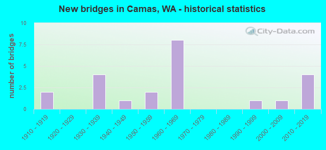
- New bridges - historical statistics
- 21910-1919
- 41930-1939
- 11940-1949
- 21950-1959
- 81960-1969
- 11990-1999
- 12000-2009
- 42010-2019
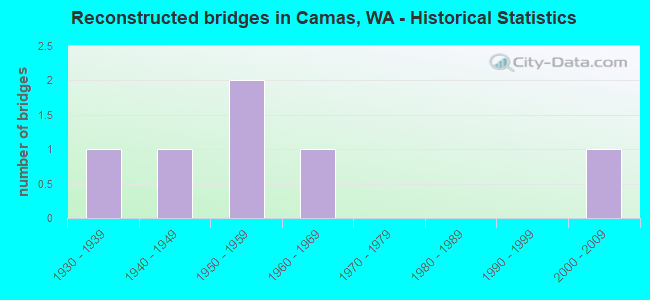
- Reconstructed bridges - Historical Statistics
- 11930-1939
- 11940-1949
- 21950-1959
- 11960-1969
- 01970-1979
- 01980-1989
- 01990-1999
- 12000-2009
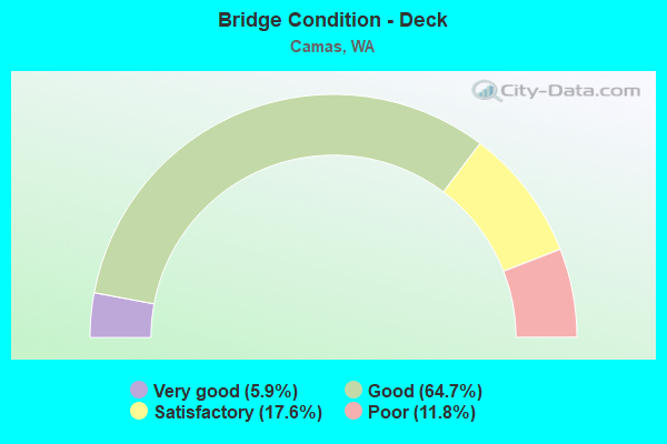
- Bridge Condition - Deck
- 5.9%Very good
- 64.7%Good
- 17.6%Satisfactory
- 11.8%Poor

- Bridge Condition - Superstructure
- 11.8%Very good
- 41.2%Good
- 41.2%Satisfactory
- 5.9%Fair
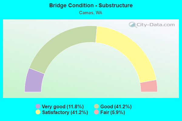
- Bridge Condition - Substructure
- 11.8%Very good
- 41.2%Good
- 41.2%Satisfactory
- 5.9%Fair
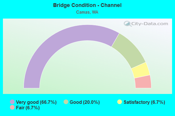
- Bridge Condition - Channel
- 66.7%Very good
- 20.0%Good
- 6.7%Satisfactory
- 6.7%Fair
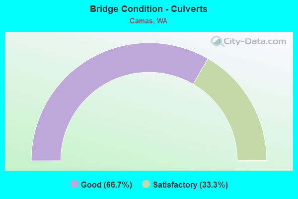
- Bridge Condition - Culverts
- 66.7%Good
- 33.3%Satisfactory
Find on map >> Show street view
Structure Number: FV, Location: 13.8 E JCT SR 503 (Lat: 45.589778, Lng: -122.403056), Route carried "on" structure: State highway 500, Year Built: 1915, Year Reconstructed: 1937, Status: Open, Structure Length: 0.76m (2.49ft), Average Daily Traffic: 7,743 (year 2019), Truck Traffic: 6%, Average Future Daily Traffic: 11,211 (year 2039), Features Intersected: HJF CANAL
Minimum Vertical Clearance: 30+ m (98+ ft), Kilometerpoint: 30.449, Lanes on structure: 2, Owner: State Highway Agency, Approaching Roadway Width: 11.3m (37.1ft), Skew: 3 degrees, Material/Design: Concrete, Design/Construction: Tee Beam, Number Of Spans In Main Unit: 1, Length of Maximum Span: 7.0m (23.0ft), Curb or Sidewalk Widths: Left: 1.8m (5.9ft), Right: 1.5m (4.9ft), Curb-To-Curb Width: 11.3m (37.1ft), Out-to-Out Width: 15.2m (49.9ft)
Condition: Deck: Poor, Superstructure: Good, Substructure: Satisfactory, Channel: Very good, Operating Rating: 22.7 metric tons, Method Used To Determine Operating Rating: Field evaluation and documented engineering judgment, Inventory Rating: 14.5 metric tons, Method Used To Determine Inventory Rating: Field evaluation and documented engineering judgment, Structural Evaluation: High priority of corrective action, Deck Geometry: Meets minimum limits, Waterway Adequacy: Equal to present desirable criteria, Approach Roadway Alignment: Equal to present desirable criteria, Length Of Structure Improvement: 0.76m (2.49ft), Designated Inspection Frequency: Every 48 months, Inspection Date: April 2018, Bridge Improvement Cost: $195,000, Roadway Improvement Cost: $39,000, Total Project Cost: $390,000 ( Estimate for 2014), Deck Structure Type: Concrete Cast-file-Place, Wearing Surface/Protective System: Wearing Surface: Bituminous, Membrane: Preformed Fabric
Find on map >> Show street view
Structure Number: II, Location: 12.6 E JCT SR 503 (Lat: 45.604389, Lng: -122.407139), Route carried "on" structure: State highway 500, Year Built: 1930, Status: Open, Structure Length: 2.41m (7.91ft), Average Daily Traffic: 11,297 (year 2019), Truck Traffic: 4%, Average Future Daily Traffic: 16,358 (year 2039), Features Intersected: LACAMAS LAKE
Minimum Vertical Clearance: 30+ m (98+ ft), Kilometerpoint: 28.598, Lanes on structure: 2, Owner: State Highway Agency, Approaching Roadway Width: 7.3m (24.0ft), Material/Design: Concrete continuous, Design/Construction: Tee Beam, Number Of Spans In Main Unit: 3, Length of Maximum Span: 9.1m (29.9ft), Curb or Sidewalk Widths: Left: 2.1m (6.9ft), Right: 0.0m, Curb-To-Curb Width: 7.3m (24.0ft), Out-to-Out Width: 9.9m (32.5ft)
Condition: Deck: Poor, Superstructure: Satisfactory, Substructure: Satisfactory, Channel: Good, Operating Rating: 62.6 metric tons, Method Used To Determine Operating Rating: Load Factor (LF), Inventory Rating: 38.1 metric tons, Method Used To Determine Inventory Rating: Load Factor (LF), Structural Evaluation: Equal to present minimum criteria, Deck Geometry: High priority of replacement, Waterway Adequacy: Equal to present desirable criteria, Approach Roadway Alignment: Equal to present desirable criteria, Length Of Structure Improvement: 2.41m (7.91ft), Designated Inspection Frequency: Every 24 months, Inspection Date: October 2021, Bridge Improvement Cost: $411,000, Roadway Improvement Cost: $82,000, Total Project Cost: $822,000 ( Estimate for 2014), Deck Structure Type: Concrete Cast-file-Place, Wearing Surface/Protective System: Wearing Surface: Bituminous, Membrane: Preformed Fabric
Find on map >> Show street view
Structure Number: 4241A, Location: 14.4 E JCT SR 503 (Lat: 45.584072, Lng: -122.397472), Route carried "on" structure: State highway 500, Year Built: 1954, Status: Open, Structure Length: 14.02m (46.00ft), Average Daily Traffic: 4,266 (year 2019), Truck Traffic: 6%, Average Future Daily Traffic: 6,177 (year 2039), Design Load: HS 15, Features Intersected: WASHOUGAL RIVER
Minimum Vertical Clearance: 30+ m (98+ ft), Kilometerpoint: 31.527, Lanes on structure: 2, Owner: State Highway Agency, Approaching Roadway Width: 11.0m (36.1ft), Material/Design: Concrete continuous, Design/Construction: Box Beam or Girders - Multiple, Number Of Spans In Main Unit: 4, Number Of Approach Spans: 2, Length of Maximum Span: 51.8m (169.9ft), Curb or Sidewalk Widths: Left: 0.3m (1.0ft), Right: 1.4m (4.6ft), Curb-To-Curb Width: 7.9m (25.9ft), Out-to-Out Width: 9.8m (32.2ft)
Condition: Deck: Good, Superstructure: Satisfactory, Substructure: Satisfactory, Channel: Very good, Operating Rating: 32.1 metric tons, Method Used To Determine Operating Rating: Load and Resistance Factor Rating (LRFR) rating reported by rating factor(RF) method using HL-93 loadings, Inventory Rating: 24.9 metric tons, Method Used To Determine Inventory Rating: Load and Resistance Factor Rating (LRFR) rating reported by rating factor(RF) method using HL-93 loadings, Structural Evaluation: Equal to present minimum criteria, Deck Geometry: High priority of corrective action, Waterway Adequacy: Equal to present desirable criteria, Approach Roadway Alignment: Equal to present desirable criteria, Length Of Structure Improvement: 14.02m (46.00ft), Designated Inspection Frequency: Every 24 months, Inspection Date: September 2021, Bridge Improvement Cost: $3,496,000, Roadway Improvement Cost: $699,000, Total Project Cost: $6,992,000 ( Estimate for 2014), Deck Structure Type: Concrete Cast-file-Place, Wearing Surface/Protective System: Wearing Surface: Bituminous, Membrane: Preformed Fabric
Find on map >> Show street view
Structure Number: 4241B, Location: 14.4 E JCT SR 503 (Lat: 45.584114, Lng: -122.397525), Route carried "on" structure: State highway 500, Year Built: 1954, Status: Open, Structure Length: 0.98m (3.22ft), Average Daily Traffic: 4,266 (year 2019), Truck Traffic: 6%, Average Future Daily Traffic: 6,177 (year 2039), Features Intersected: UTILITY VAULT
Minimum Vertical Clearance: 30+ m (98+ ft), Kilometerpoint: 31.511, Lanes on structure: 2, Owner: State Highway Agency, Approaching Roadway Width: 7.9m (25.9ft), Material/Design: Concrete, Design/Construction: Culvert, Number Of Spans In Main Unit: 1, Length of Maximum Span: 9.8m (32.2ft)
Condition: Culverts: Good, Operating Rating: 40.8 metric tons, Method Used To Determine Operating Rating: Field evaluation and documented engineering judgment, Inventory Rating: 24.5 metric tons, Method Used To Determine Inventory Rating: Field evaluation and documented engineering judgment, Structural Evaluation: Equal to present minimum criteria, Approach Roadway Alignment: Equal to present desirable criteria, Length Of Structure Improvement: 0.98m (3.22ft), Designated Inspection Frequency: Every 24 months, Inspection Date: September 2021, Bridge Improvement Cost: $179,000, Roadway Improvement Cost: $36,000, Total Project Cost: $358,000 ( Estimate for 2014)
Find on map >> Show street view
Structure Number: 6845A, Location: 7.7 E JCT I-205 (Lat: 45.576972, Lng: -122.404278), Route carried "on" structure: State highway 14, Year Built: 1962, Status: Open, Structure Length: 10.52m (34.51ft), Average Daily Traffic: 15,623 (year 2019), Truck Traffic: 9%, Average Future Daily Traffic: 22,622 (year 2039), Design Load: HS 20, Features Intersected: EAST CAMAS SLOUGH
Minimum Vertical Clearance: 30+ m (98+ ft), Kilometerpoint: 22.048, Lanes on structure: 2, Base Highway Network: Yes, Owner: State Highway Agency, Approaching Roadway Width: 10.7m (35.1ft), Navigation Control: Yes ( Vertical Clearance: 11.3m (37.1ft), Horizontal Clearance: 35.4m (116.1ft)), Material/Design: Concrete continuous, Design/Construction: Box Beam or Girders - Multiple, Number Of Spans In Main Unit: 3, Length of Maximum Span: 42.7m (140.1ft), Curb or Sidewalk Widths: Left: 0.4m (1.3ft), Right: 0.4m (1.3ft), Curb-To-Curb Width: 8.5m (27.9ft), Out-to-Out Width: 10.2m (33.5ft)
Condition: Deck: Good, Superstructure: Good, Substructure: Satisfactory, Channel: Very good, Operating Rating: 68.9 metric tons, Method Used To Determine Operating Rating: Load Factor (LF), Inventory Rating: 40.8 metric tons, Method Used To Determine Inventory Rating: Load Factor (LF), Structural Evaluation: Equal to present minimum criteria, Deck Geometry: High priority of corrective action, Waterway Adequacy: Equal to present desirable criteria, Approach Roadway Alignment: Equal to present desirable criteria, Length Of Structure Improvement: 10.52m (34.51ft), Designated Inspection Frequency: Every 24 months, Underwater Inspection Frequency: Every 60 months, Inspection Date: August 2021, Underwater Inspection Date: July 2018, Bridge Improvement Cost: $2,553,000, Roadway Improvement Cost: $511,000, Total Project Cost: $5,106,000 ( Estimate for 2014), Deck Structure Type: Concrete Cast-file-Place, Wearing Surface/Protective System: Wearing Surface: Bituminous
Find on map >> Show street view
Structure Number: 7138A, Location: 6.7 E JCT I-205 (Lat: 45.578606, Lng: -122.424639), Route carried "on" structure: State highway 14, Year Built: 1964, Year Reconstructed: 2013, Status: Open, Structure Length: 31.64m (103.81ft), Average Daily Traffic: 31,246 (year 2019), Truck Traffic: 9%, Average Future Daily Traffic: 45,244 (year 2039), Design Load: HS 20, Features Intersected: WEST CAMAS SLOUGH
Minimum Vertical Clearance: 30+ m (98+ ft), Kilometerpoint: 20.310, Lanes on structure: 2, Base Highway Network: Yes, Owner: State Highway Agency, Approaching Roadway Width: 12.2m (40.0ft), Skew: 3 degrees, Navigation Control: Yes ( Vertical Clearance: 9.8m (32.2ft), Horizontal Clearance: 70.1m (230.0ft)), Material/Design: Steel continuous, Design/Construction: Stringer/Multi-beam, Number Of Spans In Main Unit: 6, Length of Maximum Span: 86.6m (284.1ft), Curb-To-Curb Width: 9.9m (32.5ft), Out-to-Out Width: 11.2m (36.7ft)
Condition: Deck: Satisfactory, Superstructure: Good, Substructure: Good, Channel: Very good, Operating Rating: 40.8 metric tons, Method Used To Determine Operating Rating: Load Factor (LF), Inventory Rating: 24.5 metric tons, Method Used To Determine Inventory Rating: Load Factor (LF), Structural Evaluation: Equal to present minimum criteria, Deck Geometry: Meets minimum limits, Underclear: Better than present minimum criteria, Waterway Adequacy: Equal to present desirable criteria, Approach Roadway Alignment: Equal to present desirable criteria, Length Of Structure Improvement: 31.64m (103.81ft), Designated Inspection Frequency: Every 24 months, Underwater Inspection Frequency: Every 60 months, Other Special Inspection Frequency: Every 24 months, Inspection Date: April 2021, Underwater Inspection Date: July 2018, Other Special Inspection Date: April 2021, Bridge Improvement Cost: $8,719,000, Roadway Improvement Cost: $1,744,000, Total Project Cost: $17,438,000 ( Estimate for 2014), Deck Structure Type: Concrete Cast-file-Place, Wearing Surface/Protective System: Wearing Surface: Bituminous, Membrane: Preformed Fabric
Find on map >> Show street view
Structure Number: 7595A, Location: 6.3 E JCT I-205 (Lat: 45.580917, Lng: -122.429861), Route carried "on" structure: State highway 14, Year Built: 1965, Status: Open, Structure Length: 1.95m (6.40ft), Average Daily Traffic: 30,353 (year 2019), Truck Traffic: 5%, Average Future Daily Traffic: 43,951 (year 2039), Design Load: HS 20, Features Intersected: E-6TH RAMP
Minimum Vertical Clearance: 30+ m (98+ ft), Kilometerpoint: 19.827, Lanes on structure: 3, Lanes under structure: 2, Base Highway Network: Yes, Owner: State Highway Agency, Approaching Roadway Width: 25.3m (83.0ft), Skew: 34 degrees, Material/Design: Concrete, Design/Construction: Slab, Number Of Spans In Main Unit: 1, Length of Maximum Span: 19.5m (64.0ft), Curb or Sidewalk Widths: Left: 0.2m (0.7ft), Right: 0.2m (0.7ft), Curb-To-Curb Width: 24.8m (81.4ft), Out-to-Out Width: 25.8m (84.6ft)
Condition: Deck: Good, Superstructure: Satisfactory, Substructure: Good, Operating Rating: 89.8 metric tons, Method Used To Determine Operating Rating: Load Factor (LF), Inventory Rating: 89.8 metric tons, Method Used To Determine Inventory Rating: Load Factor (LF), Structural Evaluation: Equal to present minimum criteria, Deck Geometry: Superior to present desirable criteria, Underclear: Meets minimum limits, Approach Roadway Alignment: Equal to present minimum criteria, Length Of Structure Improvement: 1.95m (6.40ft), Designated Inspection Frequency: Every 24 months, Inspection Date: August 2021, Bridge Improvement Cost: $1,088,000, Roadway Improvement Cost: $218,000, Total Project Cost: $2,176,000 ( Estimate for 2014), Deck Structure Type: Concrete Cast-file-Place, Wearing Surface/Protective System: Wearing Surface: Bituminous, Membrane: Preformed Fabric
Find on map >> Show street view
Structure Number: 7595B, Location: 6.3 E JCT I-205 (Lat: 45.580389, Lng: -122.428528), Route carried "on" structure: City street , Year Built: 1965, Status: Open, Structure Length: 7.16m (23.49ft), Average Daily Traffic: 1,297 (year 2012), Truck Traffic: 5%, Average Future Daily Traffic: 2,044 (year 2036), Design Load: HS 20, Features Intersected: SR 14, Facility Carried by Structure: SW 6TH AVE
Minimum Vertical Clearance: 30+ m (98+ ft), Kilometerpoint: 0.193, Lanes on structure: 2, Lanes under structure: 5, Owner: State Highway Agency, Approaching Roadway Width: 9.1m (29.9ft), Skew: 3 degrees, Material/Design: Prestressed concrete, Design/Construction: Stringer/Multi-beam, Number Of Spans In Main Unit: 4, Length of Maximum Span: 21.9m (71.9ft), Curb or Sidewalk Widths: Left: 0.5m (1.6ft), Right: 1.2m (3.9ft), Curb-To-Curb Width: 7.9m (25.9ft), Out-to-Out Width: 10.1m (33.1ft)
Condition: Deck: Satisfactory, Superstructure: Satisfactory, Substructure: Good, Operating Rating: 59.0 metric tons, Method Used To Determine Operating Rating: Load Factor (LF), Inventory Rating: 35.4 metric tons, Method Used To Determine Inventory Rating: Load Factor (LF), Structural Evaluation: Equal to present minimum criteria, Deck Geometry: Meets minimum limits, Underclear: High priority of corrective action, Approach Roadway Alignment: Equal to present desirable criteria, Length Of Structure Improvement: 7.16m (23.49ft), Designated Inspection Frequency: Every 48 months, Inspection Date: May 2018, Bridge Improvement Cost: $1,504,000, Roadway Improvement Cost: $301,000, Total Project Cost: $3,008,000 ( Estimate for 2014), Deck Structure Type: Concrete Cast-file-Place, Wearing Surface/Protective System: Wearing Surface: Monolithic Concrete
Find on map >> Show street view
Structure Number: 8432A, Location: 14.2 E JCT SR 503 (Lat: 45.584611, Lng: -122.401556), Route carried "on" structure: State highway 500, Year Built: 1968, Status: Open, Structure Length: 7.92m (25.98ft), Average Daily Traffic: 4,484 (year 2019), Truck Traffic: 6%, Average Future Daily Traffic: 6,492 (year 2039), Design Load: HS 20+Mod, Features Intersected: BN SF RY
Minimum Vertical Clearance: 30+ m (98+ ft), Kilometerpoint: 31.189, Lanes on structure: 2, Owner: State Highway Agency, Approaching Roadway Width: 9.1m (29.9ft), Material/Design: Concrete continuous, Design/Construction: Box Beam or Girders - Single/Spread, Number Of Spans In Main Unit: 3, Length of Maximum Span: 33.5m (109.9ft), Curb or Sidewalk Widths: Left: 1.4m (4.6ft), Right: 0.2m (0.7ft), Curb-To-Curb Width: 9.1m (29.9ft), Out-to-Out Width: 11.3m (37.1ft)
Condition: Deck: Good, Superstructure: Good, Substructure: Good, Operating Rating: 66.2 metric tons, Method Used To Determine Operating Rating: Load Factor (LF), Inventory Rating: 39.0 metric tons, Method Used To Determine Inventory Rating: Load Factor (LF), Structural Evaluation: Better than present minimum criteria, Deck Geometry: Meets minimum limits, Underclear: Better than present minimum criteria, Approach Roadway Alignment: Equal to present desirable criteria, Length Of Structure Improvement: 7.92m (25.98ft), Designated Inspection Frequency: Every 24 months, Inspection Date: September 2021, Bridge Improvement Cost: $1,664,000, Roadway Improvement Cost: $333,000, Total Project Cost: $3,328,000 ( Estimate for 2014), Deck Structure Type: Concrete Cast-file-Place, Wearing Surface/Protective System: Wearing Surface: Bituminous, Membrane: Preformed Fabric
Find on map >> Show street view
Structure Number: 18105A, Location: 7.7 E JCT I-205 (Lat: 45.577189, Lng: -122.403567), Route carried "on" structure: State highway 14, Year Built: 2012, Status: Open, Structure Length: 10.52m (34.51ft), Average Daily Traffic: 15,623 (year 2019), Truck Traffic: 9%, Average Future Daily Traffic: 22,622 (year 2039), Design Load: HL 93, Features Intersected: EAST CAMAS SLOUGH
Minimum Vertical Clearance: 30+ m (98+ ft), Kilometerpoint: 22.048, Lanes on structure: 2, Base Highway Network: Yes, Owner: State Highway Agency, Approaching Roadway Width: 12.2m (40.0ft), Navigation Control: Yes ( Vertical Clearance: 9.4m (30.8ft), Horizontal Clearance: 35.4m (116.1ft)), Material/Design: Prestressed concrete continuous, Design/Construction: Stringer/Multi-beam, Number Of Spans In Main Unit: 3, Length of Maximum Span: 42.7m (140.1ft), Curb-To-Curb Width: 12.2m (40.0ft), Out-to-Out Width: 13.1m (43.0ft)
Condition: Deck: Good, Superstructure: Very good, Substructure: Very good, Channel: Very good, Operating Rating: 51.8 metric tons, Method Used To Determine Operating Rating: Load and Resistance Factor Rating (LRFR) rating reported by rating factor(RF) method using HL-93 loadings, Inventory Rating: 40.2 metric tons, Method Used To Determine Inventory Rating: Load and Resistance Factor Rating (LRFR) rating reported by rating factor(RF) method using HL-93 loadings, Structural Evaluation: Equal to present desirable criteria, Deck Geometry: Better than present minimum criteria, Waterway Adequacy: Equal to present desirable criteria, Approach Roadway Alignment: Equal to present desirable criteria, Length Of Structure Improvement: 10.52m (34.51ft), Designated Inspection Frequency: Every 24 months, Underwater Inspection Frequency: Every 60 months, Inspection Date: July 2020, Underwater Inspection Date: July 2018, Bridge Improvement Cost: $2,898,000, Roadway Improvement Cost: $580,000, Total Project Cost: $5,796,000 ( Estimate for 2014), Deck Structure Type: Concrete Cast-file-Place, Wearing Surface/Protective System: Wearing Surface: Monolithic Concrete, Deck Protection: Epoxy Coated Reinforcing
Find on map >> Show street view
Structure Number: 18105B, Location: 8.6 E JCT I-205 (Lat: 45.580111, Lng: -122.385667), Route carried "on" structure: State highway 14, Year Built: 2012, Status: Open, Structure Length: 2.99m (9.81ft), Average Daily Traffic: 23,986 (year 2019), Truck Traffic: 8%, Average Future Daily Traffic: 34,731 (year 2039), Design Load: HL 93, Features Intersected: SR 500 / UNION ST
Minimum Vertical Clearance: 30+ m (98+ ft), Kilometerpoint: 23.529, Lanes on structure: 4, Lanes under structure: 2, Base Highway Network: Yes, Owner: State Highway Agency, Approaching Roadway Width: 23.2m (76.1ft), Skew: 30 degrees, Material/Design: Prestressed concrete, Design/Construction: Stringer/Multi-beam, Number Of Spans In Main Unit: 1, Length of Maximum Span: 29.9m (98.1ft), Curb-To-Curb Width: 23.2m (76.1ft), Out-to-Out Width: 24.4m (80.1ft)
Condition: Deck: Good, Superstructure: Very good, Substructure: Very good, Operating Rating: 69.0 metric tons, Method Used To Determine Operating Rating: Load and Resistance Factor Rating (LRFR) rating reported by rating factor(RF) method using HL-93 loadings, Inventory Rating: 51.2 metric tons, Method Used To Determine Inventory Rating: Load and Resistance Factor Rating (LRFR) rating reported by rating factor(RF) method using HL-93 loadings, Structural Evaluation: Equal to present desirable criteria, Deck Geometry: Superior to present desirable criteria, Underclear: Equal to present minimum criteria, Approach Roadway Alignment: Equal to present desirable criteria, Length Of Structure Improvement: 2.99m (9.81ft), Designated Inspection Frequency: Every 48 months, Inspection Date: Febuary 2019, Bridge Improvement Cost: $1,529,000, Roadway Improvement Cost: $306,000, Total Project Cost: $3,058,000 ( Estimate for 2014), Deck Structure Type: Concrete Cast-file-Place, Wearing Surface/Protective System: Wearing Surface: Monolithic Concrete, Deck Protection: Epoxy Coated Reinforcing
Find on map >> Show street view
Structure Number: 80874, Location: 0.2N JCT NE58 ST (Lat: 45.667967, Lng: -122.434567), Route carried "on" structure: County highway 31650, Year Built: 1930, Year Reconstructed: 1953, Status: Posted for load, Structure Length: 0.76m (2.49ft), Average Daily Traffic: 814 (year 2016), Truck Traffic: 3%, Average Future Daily Traffic: 2,102 (year 2038), Design Load: HS 15, Features Intersected: MATNEY CREEK, Facility Carried by Structure: NE 232ND AVE
Minimum Vertical Clearance: 30+ m (98+ ft), Kilometerpoint: 0.001, Lanes on structure: 2, Owner: County Highway Agency, Approaching Roadway Width: 7.0m (23.0ft), Material/Design: Concrete, Design/Construction: Stringer/Multi-beam, Number Of Spans In Main Unit: 1, Length of Maximum Span: 7.6m (24.9ft), Curb or Sidewalk Widths: Left: 0.2m (0.7ft), Right: 0.2m (0.7ft), Curb-To-Curb Width: 6.7m (22.0ft), Out-to-Out Width: 7.2m (23.6ft)
Condition: Deck: Good, Superstructure: Satisfactory, Substructure: Fair, Channel: Satisfactory, Operating Rating: 19.4 metric tons, Method Used To Determine Operating Rating: Load and Resistance Factor Rating (LRFR) rating reported by rating factor(RF) method using HL-93 loadings, Inventory Rating: 14.9 metric tons, Method Used To Determine Inventory Rating: Load and Resistance Factor Rating (LRFR) rating reported by rating factor(RF) method using HL-93 loadings, Structural Evaluation: Meets minimum limits, Deck Geometry: Meets minimum limits, Waterway Adequacy: Equal to present minimum criteria, Approach Roadway Alignment: Equal to present desirable criteria, Bridge Posting: Required (Relationship of Operating Rating to Maximum Legal Load: > 39.9% below), Length Of Structure Improvement: 1.07m (3.51ft), Designated Inspection Frequency: Every 24 months, Inspection Date: November 2020, Bridge Improvement Cost: $532,000, Roadway Improvement Cost: $106,000, Total Project Cost: $1,064,000 ( Estimate for 2014), Deck Structure Type: Concrete Cast-file-Place, Wearing Surface/Protective System: Wearing Surface: Bituminous
Find on map >> Show street view
Structure Number: 80952, Location: 0.4E OF NE217 AVE (Lat: 45.672367, Lng: -122.439950), Route carried "on" structure: County highway 30740, Year Built: 1938, Year Reconstructed: 1955, Status: Posted for load, Structure Length: 0.91m (2.99ft), Average Daily Traffic: 807 (year 2017), Truck Traffic: 13%, Average Future Daily Traffic: 2,102 (year 2038), Design Load: HS 15, Features Intersected: MATNEY CREEK, Facility Carried by Structure: NE 68TH ST
Minimum Vertical Clearance: 30+ m (98+ ft), Kilometerpoint: 0.001, Lanes on structure: 2, Owner: County Highway Agency, Approaching Roadway Width: 7.3m (24.0ft), Material/Design: Concrete, Design/Construction: Stringer/Multi-beam, Number Of Spans In Main Unit: 1, Length of Maximum Span: 9.1m (29.9ft), Curb or Sidewalk Widths: Left: 0.2m (0.7ft), Right: 0.2m (0.7ft), Curb-To-Curb Width: 6.8m (22.3ft), Out-to-Out Width: 7.2m (23.6ft)
Condition: Deck: Very good, Superstructure: Good, Substructure: Satisfactory, Channel: Fair, Operating Rating: 14.9 metric tons, Method Used To Determine Operating Rating: Load and Resistance Factor Rating (LRFR) rating reported by rating factor(RF) method using HL-93 loadings, Inventory Rating: 11.7 metric tons, Method Used To Determine Inventory Rating: Load and Resistance Factor Rating (LRFR) rating reported by rating factor(RF) method using HL-93 loadings, Structural Evaluation: High priority of replacement, Deck Geometry: Meets minimum limits, Waterway Adequacy: Better than present minimum criteria, Approach Roadway Alignment: Equal to present desirable criteria, Bridge Posting: Required (Relationship of Operating Rating to Maximum Legal Load: > 39.9% below), Length Of Structure Improvement: 1.22m (4.00ft), Designated Inspection Frequency: Every 24 months, Inspection Date: June 2021, Bridge Improvement Cost: $608,000, Roadway Improvement Cost: $122,000, Total Project Cost: $1,216,000 ( Estimate for 2014), Deck Structure Type: Concrete Cast-file-Place, Wearing Surface/Protective System: Wearing Surface: Bituminous
Find on map >> Show street view
Structure Number: 82699, Location: 3500' E NE 202 AV (Lat: 45.638800, Lng: -122.456683), Route carried "on" structure: City street 93350, Year Built: 1933, Year Reconstructed: 1957, Status: Open, Structure Length: 2.19m (7.19ft), Average Daily Traffic: 7,195 (year 2016), Truck Traffic: 10%, Average Future Daily Traffic: 6,944 (year 2037), Design Load: HS 15, Features Intersected: LACAMAS CREEK, Facility Carried by Structure: NE GOODWIN RD
Minimum Vertical Clearance: 30+ m (98+ ft), Kilometerpoint: 0.001, Lanes on structure: 2, Owner: City or Municipal Highway Agency, Approaching Roadway Width: 7.6m (24.9ft), Skew: 1 degrees, Material/Design: Prestressed concrete, Design/Construction: Stringer/Multi-beam, Number Of Spans In Main Unit: 2, Length of Maximum Span: 11.0m (36.1ft), Curb or Sidewalk Widths: Left: 0.2m (0.7ft), Right: 0.2m (0.7ft), Curb-To-Curb Width: 8.6m (28.2ft), Out-to-Out Width: 9.1m (29.9ft)
Condition: Deck: Good, Superstructure: Good, Substructure: Good, Channel: Very good, Operating Rating: 31.1 metric tons, Method Used To Determine Operating Rating: Load and Resistance Factor Rating (LRFR) rating reported by rating factor(RF) method using HL-93 loadings, Inventory Rating: 24.0 metric tons, Method Used To Determine Inventory Rating: Load and Resistance Factor Rating (LRFR) rating reported by rating factor(RF) method using HL-93 loadings, Structural Evaluation: Somewhat better than minimum adequacy, Deck Geometry: High priority of replacement, Waterway Adequacy: Better than present minimum criteria, Approach Roadway Alignment: Equal to present desirable criteria, Length Of Structure Improvement: 2.50m (8.20ft), Designated Inspection Frequency: Every 24 months, Inspection Date: September 2021, Bridge Improvement Cost: $1,246,000, Roadway Improvement Cost: $249,000, Total Project Cost: $2,493,000 ( Estimate for 2014), Deck Structure Type: Concrete Cast-file-Place, Wearing Surface/Protective System: Wearing Surface: Monolithic Concrete
Find on map >> Show street view
Structure Number: 85071, Location: 1.4 E JCT. SR 500 (Lat: 45.587611, Lng: -122.372611), Route carried "on" structure: City street 145, Year Built: 1947, Year Reconstructed: 1969, Status: Open, Structure Length: 6.86m (22.51ft), Average Daily Traffic: 9,924 (year 2016), Truck Traffic: 5%, Average Future Daily Traffic: 32,704 (year 2038), Design Load: HS 20, Features Intersected: WASHOUGAL RIVER, Facility Carried by Structure: NE 3 AVE.
Minimum Vertical Clearance: 30+ m (98+ ft), Kilometerpoint: 0.001, Lanes on structure: 4, Base Highway Network: Yes, Owner: City or Municipal Highway Agency, Approaching Roadway Width: 14.6m (47.9ft), Material/Design: Steel, Design/Construction: Stringer/Multi-beam, Number Of Spans In Main Unit: 2, Length of Maximum Span: 33.2m (108.9ft), Curb or Sidewalk Widths: Left: 1.8m (5.9ft), Right: 1.8m (5.9ft), Curb-To-Curb Width: 14.6m (47.9ft), Out-to-Out Width: 18.3m (60.0ft)
Condition: Deck: Good, Superstructure: Satisfactory, Substructure: Satisfactory, Channel: Very good, Operating Rating: 33.6 metric tons, Method Used To Determine Operating Rating: Load and Resistance Factor (LRFR), Inventory Rating: 20.0 metric tons, Method Used To Determine Inventory Rating: Load and Resistance Factor (LRFR), Structural Evaluation: Somewhat better than minimum adequacy, Deck Geometry: High priority of replacement, Waterway Adequacy: Equal to present desirable criteria, Approach Roadway Alignment: Equal to present desirable criteria, Length Of Structure Improvement: 7.16m (23.49ft), Designated Inspection Frequency: Every 24 months, Inspection Date: September 2020, Bridge Improvement Cost: $5,828,000, Roadway Improvement Cost: $1,166,000, Total Project Cost: $11,656,000 ( Estimate for 2014), Deck Structure Type: Concrete Cast-file-Place, Wearing Surface/Protective System: Wearing Surface: Bituminous
Find on map >> Show street view
Structure Number: 85153, Location: 0.15 N JCT NW 6AVE (Lat: 45.587556, Lng: -122.409722), Route carried "on" structure: City street 145, Year Built: 1960, Status: Posted for load, Structure Length: 0.91m (2.99ft), Average Daily Traffic: 2,518 (year 2017), Truck Traffic: 5%, Average Future Daily Traffic: 7,401 (year 2039), Design Load: HS 20, Features Intersected: CROWN Z MILL WATER CANAL, Facility Carried by Structure: DIVISION STREET
Minimum Vertical Clearance: 30+ m (98+ ft), Kilometerpoint: 0.001, Lanes on structure: 2, Owner: City or Municipal Highway Agency, Approaching Roadway Width: 8.5m (27.9ft), Material/Design: Prestressed concrete, Design/Construction: Stringer/Multi-beam, Number Of Spans In Main Unit: 1, Length of Maximum Span: 9.1m (29.9ft), Curb or Sidewalk Widths: Left: 0.3m (1.0ft), Right: 1.6m (5.2ft), Curb-To-Curb Width: 8.4m (27.6ft), Out-to-Out Width: 11.0m (36.1ft)
Condition: Deck: Satisfactory, Superstructure: Satisfactory, Substructure: Satisfactory, Channel: Very good, Operating Rating: 30.8 metric tons, Method Used To Determine Operating Rating: Load and Resistance Factor Rating (LRFR) rating reported by rating factor(RF) method using HL-93 loadings, Inventory Rating: 23.7 metric tons, Method Used To Determine Inventory Rating: Load and Resistance Factor Rating (LRFR) rating reported by rating factor(RF) method using HL-93 loadings, Structural Evaluation: Equal to present minimum criteria, Deck Geometry: High priority of corrective action, Waterway Adequacy: Equal to present desirable criteria, Approach Roadway Alignment: Equal to present desirable criteria, Length Of Structure Improvement: 1.22m (4.00ft), Designated Inspection Frequency: Every 24 months, Inspection Date: April 2020, Bridge Improvement Cost: $608,000, Roadway Improvement Cost: $122,000, Total Project Cost: $1,216,000 ( Estimate for 2014), Deck Structure Type: Other, Wearing Surface/Protective System: Wearing Surface: Monolithic Concrete
Find on map >> Show street view
Structure Number: 85888, Location: 0.1N JCT NE68 ST (Lat: 45.672714, Lng: -122.450075), Route carried "on" structure: County highway 52910, Year Built: 1991, Status: Open, Structure Length: 3.26m (10.70ft), Average Daily Traffic: 619 (year 2017), Truck Traffic: 1%, Average Future Daily Traffic: 1,903 (year 2039), Features Intersected: LACAMAS CREEK, Facility Carried by Structure: NE 217TH AVE
Minimum Vertical Clearance: 30+ m (98+ ft), Kilometerpoint: 0.001, Lanes on structure: 2, Owner: County Highway Agency, Approaching Roadway Width: 8.8m (28.9ft), Skew: 2 degrees, Material/Design: Prestressed concrete, Design/Construction: Tee Beam, Number Of Spans In Main Unit: 1, Length of Maximum Span: 32.0m (105.0ft), Curb-To-Curb Width: 8.5m (27.9ft), Out-to-Out Width: 8.5m (27.9ft)
Condition: Deck: Good, Superstructure: Good, Substructure: Good, Channel: Good, Operating Rating: 41.8 metric tons, Method Used To Determine Operating Rating: Load and Resistance Factor Rating (LRFR) rating reported by rating factor(RF) method using HL-93 loadings, Inventory Rating: 32.4 metric tons, Method Used To Determine Inventory Rating: Load and Resistance Factor Rating (LRFR) rating reported by rating factor(RF) method using HL-93 loadings, Structural Evaluation: Better than present minimum criteria, Deck Geometry: Somewhat better than minimum adequacy, Waterway Adequacy: Equal to present desirable criteria, Approach Roadway Alignment: Equal to present desirable criteria, Length Of Structure Improvement: 3.57m (11.71ft), Designated Inspection Frequency: Every 24 months, Inspection Date: August 2021, Bridge Improvement Cost: $1,778,000, Roadway Improvement Cost: $356,000, Total Project Cost: $3,557,000 ( Estimate for 2014), Deck Structure Type: Other, Wearing Surface/Protective System: Wearing Surface: Bituminous, Membrane: Preformed Fabric, Deck Protection: Epoxy Coated Reinforcing
Find on map >> Show street view
Structure Number: 8706, Location: 0.1 MI N OF 7TH AVE (Lat: 45.589078, Lng: -122.406383), Route carried "on" structure: City street 145, Year Built: 1919, Status: Posted for load, Structure Length: 0.70m (2.30ft), Average Daily Traffic: 4,231 (year 2016), Truck Traffic: 2%, Average Future Daily Traffic: 7,200 (year 2037), Features Intersected: CROWN Z MILL WATER DITCH, Facility Carried by Structure: DALLAS STREET
Minimum Vertical Clearance: 30+ m (98+ ft), Kilometerpoint: 0.001, Lanes on structure: 2, Owner: City or Municipal Highway Agency, Approaching Roadway Width: 7.3m (24.0ft), Material/Design: Concrete continuous, Design/Construction: Slab, Number Of Spans In Main Unit: 1, Length of Maximum Span: 6.7m (22.0ft), Curb or Sidewalk Widths: Left: 1.8m (5.9ft), Right: 1.8m (5.9ft), Curb-To-Curb Width: 7.3m (24.0ft), Out-to-Out Width: 11.6m (38.1ft)
Condition: Deck: Good, Superstructure: Fair, Substructure: Good, Channel: Very good, Operating Rating: 19.8 metric tons, Method Used To Determine Operating Rating: Load and Resistance Factor Rating (LRFR) rating reported by rating factor(RF) method using HL-93 loadings, Inventory Rating: 15.2 metric tons, Method Used To Determine Inventory Rating: Load and Resistance Factor Rating (LRFR) rating reported by rating factor(RF) method using HL-93 loadings, Structural Evaluation: Meets minimum limits, Deck Geometry: High priority of replacement, Waterway Adequacy: Equal to present desirable criteria, Approach Roadway Alignment: Equal to present desirable criteria, Bridge Posting: Required (Relationship of Operating Rating to Maximum Legal Load: 10.0 - 19.9% below), Length Of Structure Improvement: 1.01m (3.31ft), Designated Inspection Frequency: Every 24 months, Inspection Date: April 2020, Bridge Improvement Cost: $502,000, Roadway Improvement Cost: $100,000, Total Project Cost: $1,003,000 ( Estimate for 2014), Deck Structure Type: Concrete Cast-file-Place, Wearing Surface/Protective System: Wearing Surface: Bituminous
Find on map >> Show street view
Structure Number: 87061, Location: 0.1 M E NE OF GOODWIN RD (Lat: 45.632667, Lng: -122.459111), Route carried "on" structure: ServiceCity street 145, Year Built: 2000, Status: Open, Structure Length: 1.34m (4.40ft), Average Daily Traffic: 350 (year 2019), Truck Traffic: 5%, Average Future Daily Traffic: 1,053 (year 2039), Design Load: HS 25 or greater, Features Intersected: DWYER CREEK, Facility Carried by Structure: CAMAS MEADOWS DRV.
Minimum Vertical Clearance: 30+ m (98+ ft), Kilometerpoint: 0.001, Lanes on structure: 2, Owner: City or Municipal Highway Agency, Approaching Roadway Width: 12.8m (42.0ft), Skew: 1 degrees, Material/Design: Concrete, Design/Construction: Culvert, Number Of Spans In Main Unit: 1, Length of Maximum Span: 12.8m (42.0ft), Curb or Sidewalk Widths: Left: 3.6m (11.8ft), Right: 1.7m (5.6ft), Curb-To-Curb Width: 9.5m (31.2ft), Out-to-Out Width: 11.5m (37.7ft)
Condition: Channel: Good, Culverts: Satisfactory, Operating Rating: 46.7 metric tons, Method Used To Determine Operating Rating: Load and Resistance Factor Rating (LRFR) rating reported by rating factor(RF) method using HL-93 loadings, Inventory Rating: 36.0 metric tons, Method Used To Determine Inventory Rating: Load and Resistance Factor Rating (LRFR) rating reported by rating factor(RF) method using HL-93 loadings, Structural Evaluation: Equal to present minimum criteria, Deck Geometry: Equal to present minimum criteria, Waterway Adequacy: Equal to present desirable criteria, Approach Roadway Alignment: Equal to present minimum criteria, Length Of Structure Improvement: 1.65m (5.41ft), Designated Inspection Frequency: Every 24 months, Inspection Date: May 2021, Bridge Improvement Cost: $821,000, Roadway Improvement Cost: $164,000, Total Project Cost: $1,642,000 ( Estimate for 2014)
Find on map >> Show street view
Structure Number: 88552, Location: .25 miles west of 283rd (Lat: 45.604436, Lng: -122.385850), Route carried "on" structure: City street 145, Year Built: 2013, Status: Open, Structure Length: 1.07m (3.51ft), Average Daily Traffic: 200 (year 2019), Truck Traffic: 1%, Average Future Daily Traffic: 400 (year 2037), Design Load: HS 25 or greater, Features Intersected: Tributary to Lacamas Ck, Facility Carried by Structure: NE Woodburn Drive
Minimum Vertical Clearance: 30+ m (98+ ft), Kilometerpoint: 0.001, Lanes on structure: 2, Owner: City or Municipal Highway Agency, Approaching Roadway Width: 11.3m (37.1ft), Material/Design: Steel, Design/Construction: Culvert, Number Of Spans In Main Unit: 1, Length of Maximum Span: 10.7m (35.1ft), Curb or Sidewalk Widths: Left: 3.0m (9.8ft), Right: 0.0m, Curb-To-Curb Width: 11.1m (36.4ft), Out-to-Out Width: 18.9m (62.0ft)
Condition: Channel: Very good, Culverts: Good, Operating Rating: 96.9 metric tons, Method Used To Determine Operating Rating: Load and Resistance Factor Rating (LRFR) rating reported by rating factor(RF) method using HL-93 loadings, Inventory Rating: 95.9 metric tons, Method Used To Determine Inventory Rating: Load and Resistance Factor Rating (LRFR) rating reported by rating factor(RF) method using HL-93 loadings, Structural Evaluation: Better than present minimum criteria, Deck Geometry: Superior to present desirable criteria, Waterway Adequacy: Equal to present desirable criteria, Approach Roadway Alignment: Equal to present minimum criteria, Length Of Structure Improvement: 1.37m (4.49ft), Designated Inspection Frequency: Every 24 months, Inspection Date: November 2021, Bridge Improvement Cost: $684,000, Roadway Improvement Cost: $137,000, Total Project Cost: $1,368,000 ( Estimate for 2014)
Find on map >> Show street view
Structure Number: 7595A, Location: 6.1 E JCT I-205 (Lat: 45.580917, Lng: -122.429861), Route carried "under" structure: Ramp State highway 14, Year Built: 1965, Structure Length: 0. m, Average Daily Traffic: 8,889 (year 2019), Truck Traffic: 3%, Features Intersected: E-6TH RAMP
Minimum Vertical Clearance: 5.16m (16.93ft), Kilometerpoint: 0.499, Lanes on structure: 3, Lanes under structure: 2, Material/Design: Concrete, Design/Construction: Slab, Length of Maximum Span: 19.5m (64.0ft)
Find on map >> Show street view
Structure Number: 7595B, Location: 6.3 E JCT I-205 (Lat: 45.580389, Lng: -122.428528), Route carried "under" structure: State highway 14, Year Built: 1965, Structure Length: 0. m, Average Daily Traffic: 30,353 (year 2019), Truck Traffic: 5%, Features Intersected: SR 14, Facility Carried by Structure: SW 6TH AVE
Minimum Vertical Clearance: 5.16m (16.93ft), Kilometerpoint: 19.956, Lanes on structure: 2, Lanes under structure: 5, Material/Design: Prestressed concrete, Design/Construction: Stringer/Multi-beam, Length of Maximum Span: 21.9m (71.9ft)
Find on map >> Show street view
Structure Number: 18105B, Location: 15.2 E JCT SR 503 (Lat: 45.580111, Lng: -122.385667), Route carried "under" structure: State highway 500, Year Built: 2012, Structure Length: 0. m, Average Daily Traffic: 3,578 (year 2019), Truck Traffic: 6%, Features Intersected: SR 500 / UNION ST, Facility Carried by Structure: SR 14
Minimum Vertical Clearance: 5.36m (17.59ft), Kilometerpoint: 32.782, Lanes on structure: 4, Lanes under structure: 2, Material/Design: Prestressed concrete, Design/Construction: Stringer/Multi-beam, Length of Maximum Span: 29.9m (98.1ft)