Bridge Statistics for Camden, Indiana (IN)
Condition, Traffic, Stress, Structural Evaluation, Project Costs
- National Bridge Inventory (NBI) Statistics
- 21Number of bridges
- 230ft / 69.9mTotal length
- $100,000Total costs
- 36,481Total average daily traffic
- 4,271Total average daily truck traffic
- National Bridge Inventory (NBI) Registered Bridges for Camden
- No street view available for this location
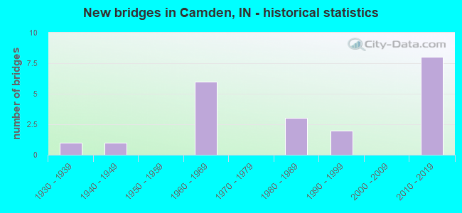
- New bridges - historical statistics
- 11930-1939
- 11940-1949
- 61960-1969
- 31980-1989
- 21990-1999
- 82010-2019

- Reconstructed bridges - Historical Statistics
- 11970-1979
- 01980-1989
- 01990-1999
- 12000-2009
- 12010-2019
- 12020-2022


- Bridge Condition - Deck
- 6.3%Very good
- 43.8%Good
- 43.8%Satisfactory
- 6.3%Fair

- Bridge Condition - Superstructure
- 29.4%Very good
- 35.3%Good
- 29.4%Satisfactory
- 5.9%Fair

- Bridge Condition - Substructure
- 23.5%Very good
- 47.1%Good
- 17.6%Satisfactory
- 11.8%Fair

- Bridge Condition - Channel
- 26.7%Very good
- 26.7%Good
- 40.0%Satisfactory
- 6.7%Fair
Find on map >> Show street view
Structure Number: 671, Location: 03.55 E I-65 (Lat: 40.419789, Lng: -86.754600), Route carried "on" structure: State highway 26, Year Built: 1988, Year Reconstructed: 2016, Status: Open, Structure Length: 2.64m (8.66ft), Average Daily Traffic: 7,910 (year 2006), Truck Traffic: 7%, Average Future Daily Traffic: 10,956 (year 2030), Design Load: HS 20, Features Intersected: COFFEE RUN CREEK
Minimum Vertical Clearance: 30+ m (98+ ft), Kilometerpoint: 30.143, Lanes on structure: 2, Base Highway Network: Yes (, Subroute: 1), Owner: State Highway Agency, Approaching Roadway Width: 13.4m (44.0ft), Skew: 4 degrees, Material/Design: Concrete continuous, Design/Construction: Slab, Number Of Spans In Main Unit: 3, Length of Maximum Span: 9.6m (31.5ft), Curb-To-Curb Width: 13.4m (44.0ft), Out-to-Out Width: 14.5m (47.6ft)
Condition: Deck: Good, Superstructure: Good, Substructure: Satisfactory, Channel: Very good, Operating Rating: 51.8 metric tons, Method Used To Determine Operating Rating: Load and Resistance Factor Rating (LRFR) rating reported by rating factor(RF) method using HL-93 loadings, Inventory Rating: 39.9 metric tons, Method Used To Determine Inventory Rating: Load and Resistance Factor Rating (LRFR) rating reported by rating factor(RF) method using HL-93 loadings, Structural Evaluation: Equal to present minimum criteria, Deck Geometry: Equal to present minimum criteria, Waterway Adequacy: Superior to present desirable criteria, Approach Roadway Alignment: Equal to present desirable criteria, Designated Inspection Frequency: Every 24 months, Inspection Date: January 2022, Deck Structure Type: Concrete Cast-file-Place, Wearing Surface/Protective System: Wearing Surface: Epoxy Overlay, Deck Protection: Epoxy Coated Reinforcing
Find on map >> Show street view
Structure Number: 1989, Location: 01.43 E US 41 (Lat: 38.486931, Lng: -87.547531), Route carried "on" structure: State highway 56, Year Built: 1964, Year Reconstructed: 1977, Status: Open, Structure Length: 3.08m (10.10ft), Average Daily Traffic: 2,249 (year 2004), Truck Traffic: 10%, Average Future Daily Traffic: 3,734 (year 2034), Design Load: HS 20, Features Intersected: ROBB CREEK
Minimum Vertical Clearance: 30+ m (98+ ft), Kilometerpoint: 2.301, Lanes on structure: 2, Owner: State Highway Agency, Approaching Roadway Width: 6.1m (20.0ft), Material/Design: Concrete continuous, Design/Construction: Slab, Number Of Spans In Main Unit: 3, Length of Maximum Span: 12.9m (42.3ft), Curb-To-Curb Width: 9.1m (29.9ft), Out-to-Out Width: 9.9m (32.5ft)
Condition: Deck: Satisfactory, Superstructure: Satisfactory, Substructure: Satisfactory, Channel: Satisfactory, Operating Rating: 43.2 metric tons, Method Used To Determine Operating Rating: Load Factor (LF), Inventory Rating: 25.9 metric tons, Method Used To Determine Inventory Rating: Load Factor (LF), Structural Evaluation: Equal to present minimum criteria, Deck Geometry: Meets minimum limits, Waterway Adequacy: Superior to present desirable criteria, Approach Roadway Alignment: Equal to present minimum criteria, Designated Inspection Frequency: Every 24 months, Inspection Date: September 2020, Deck Structure Type: Concrete Cast-file-Place, Wearing Surface/Protective System: Wearing Surface: Epoxy Overlay, Deck Protection: Epoxy Coated Reinforcing
Find on map >> Show street view
Structure Number: 25, Location: 00.46 S SR 218 (Lat: 40.603039, Lng: -86.535461), Route carried "on" structure: State highway 75, Year Built: 1965, Year Reconstructed: 2020, Status: Open, Structure Length: 6.23m (20.44ft), Average Daily Traffic: 1,178 (year 2020), Truck Traffic: 10%, Average Future Daily Traffic: 2,543 (year 2030), Design Load: HS 20, Features Intersected: DEER CREEK
Minimum Vertical Clearance: 30+ m (98+ ft), Kilometerpoint: 19.280, Lanes on structure: 2, Owner: State Highway Agency, Approaching Roadway Width: 10.4m (34.1ft), Material/Design: Steel continuous, Design/Construction: Stringer/Multi-beam, Number Of Spans In Main Unit: 3, Length of Maximum Span: 23.8m (78.1ft), Curb-To-Curb Width: 9.6m (31.5ft), Out-to-Out Width: 10.5m (34.4ft)
Condition: Deck: Satisfactory, Superstructure: Good, Substructure: Good, Channel: Satisfactory, Operating Rating: 34.7 metric tons, Method Used To Determine Operating Rating: Load and Resistance Factor Rating (LRFR) rating reported by rating factor(RF) method using HL-93 loadings, Inventory Rating: 26.6 metric tons, Method Used To Determine Inventory Rating: Load and Resistance Factor Rating (LRFR) rating reported by rating factor(RF) method using HL-93 loadings, Structural Evaluation: Equal to present minimum criteria, Deck Geometry: Somewhat better than minimum adequacy, Waterway Adequacy: Superior to present desirable criteria, Approach Roadway Alignment: Equal to present desirable criteria, Designated Inspection Frequency: Every 24 months, Underwater Inspection Frequency: Every 60 months, Inspection Date: November 2021, Underwater Inspection Date: July 2021, Deck Structure Type: Concrete Cast-file-Place, Wearing Surface/Protective System: Wearing Surface: Latex Concrete
Find on map >> Show street view
Structure Number: 2891, Location: 00.62 E SR 75 (Lat: 40.608150, Lng: -86.527631), Route carried "on" structure: State highway 218, Year Built: 1940, Status: Open, Structure Length: 1.98m (6.50ft), Average Daily Traffic: 1,675 (year 2004), Truck Traffic: 10%, Average Future Daily Traffic: 2,781 (year 2029), Design Load: H 20, Features Intersected: PAINT CREEK
Minimum Vertical Clearance: 30+ m (98+ ft), Kilometerpoint: 10.396, Lanes on structure: 2, Owner: State Highway Agency, Approaching Roadway Width: 7.9m (25.9ft), Skew: 1 degrees, Material/Design: Concrete, Design/Construction: Arch - Deck, Number Of Spans In Main Unit: 1, Length of Maximum Span: 19.8m (65.0ft), Curb or Sidewalk Widths: Left: 0.2m (0.7ft), Right: 0.2m (0.7ft), Curb-To-Curb Width: 8.5m (27.9ft), Out-to-Out Width: 9.4m (30.8ft)
Condition: Superstructure: Very good, Substructure: Good, Channel: Very good, Operating Rating: 56.5 metric tons, Method Used To Determine Operating Rating: Field evaluation and documented engineering judgment, Inventory Rating: 33.9 metric tons, Method Used To Determine Inventory Rating: Field evaluation and documented engineering judgment, Structural Evaluation: Better than present minimum criteria, Deck Geometry: Somewhat better than minimum adequacy, Waterway Adequacy: Equal to present desirable criteria, Approach Roadway Alignment: Equal to present desirable criteria, Designated Inspection Frequency: Every 24 months, Inspection Date: Febuary 2022
Find on map >> Show street view
Structure Number: 8055, Location: 04.29 N SR 218 (Lat: 40.645111, Lng: -86.577819), Route carried "on" structure: City street , Year Built: 2013, Status: Open, Structure Length: 6.75m (22.15ft), Average Daily Traffic: 520 (year 2010), Truck Traffic: 9%, Average Future Daily Traffic: 630 (year 2030), Design Load: HL 93, Features Intersected: SR 25 NB/SB, Facility Carried by Structure: WALNUT STREET
Minimum Vertical Clearance: 30+ m (98+ ft), Kilometerpoint: 0.000, Lanes on structure: 2, Lanes under structure: 4, Owner: State Highway Agency, Approaching Roadway Width: 9.1m (29.9ft), Material/Design: Prestressed concrete continuous, Design/Construction: Tee Beam, Number Of Spans In Main Unit: 2, Length of Maximum Span: 35.6m (116.8ft), Curb-To-Curb Width: 9.1m (29.9ft), Out-to-Out Width: 10.1m (33.1ft)
Condition: Deck: Good, Superstructure: Good, Substructure: Good, Operating Rating: 52.5 metric tons, Method Used To Determine Operating Rating: Load and Resistance Factor Rating (LRFR) rating reported by rating factor(RF) method using HL-93 loadings, Inventory Rating: 29.2 metric tons, Method Used To Determine Inventory Rating: Load and Resistance Factor Rating (LRFR) rating reported by rating factor(RF) method using HL-93 loadings, Structural Evaluation: Better than present minimum criteria, Deck Geometry: Equal to present minimum criteria, Underclear: Superior to present desirable criteria, Approach Roadway Alignment: Equal to present desirable criteria, Designated Inspection Frequency: Every 24 months, Inspection Date: March 2021, Deck Structure Type: Concrete Cast-file-Place, Wearing Surface/Protective System: Wearing Surface: Monolithic Concrete, Deck Protection: Epoxy Coated Reinforcing
Find on map >> Show street view
Structure Number: 80552, Location: 05.64 N SR 218 (Lat: 40.652400, Lng: -86.554611), Route carried "on" structure: State highway 25, Year Built: 2013, Status: Open, Structure Length: 6.56m (21.52ft), Average Daily Traffic: 3,100 (year 2010), Truck Traffic: 22%, Average Future Daily Traffic: 4,050 (year 2030), Design Load: HL 93, Features Intersected: ROCK CREEK
Minimum Vertical Clearance: 30+ m (98+ ft), Kilometerpoint: 18.509, Lanes on structure: 2, Base Highway Network: Yes (, Subroute: 1), Owner: State Highway Agency, Approaching Roadway Width: 12.8m (42.0ft), Skew: 2 degrees, Material/Design: Prestressed concrete continuous, Design/Construction: Tee Beam, Number Of Spans In Main Unit: 3, Length of Maximum Span: 27.4m (89.9ft), Curb-To-Curb Width: 12.8m (42.0ft), Out-to-Out Width: 13.7m (44.9ft)
Condition: Deck: Good, Superstructure: Very good, Substructure: Very good, Channel: Very good, Operating Rating: 48.6 metric tons, Method Used To Determine Operating Rating: Load and Resistance Factor Rating (LRFR) rating reported by rating factor(RF) method using HL-93 loadings, Inventory Rating: 28.8 metric tons, Method Used To Determine Inventory Rating: Load and Resistance Factor Rating (LRFR) rating reported by rating factor(RF) method using HL-93 loadings, Structural Evaluation: Better than present minimum criteria, Deck Geometry: Equal to present minimum criteria, Waterway Adequacy: Superior to present desirable criteria, Approach Roadway Alignment: Equal to present desirable criteria, Designated Inspection Frequency: Every 24 months, Inspection Date: March 2021, Deck Structure Type: Concrete Cast-file-Place, Wearing Surface/Protective System: Wearing Surface: Monolithic Concrete, Deck Protection: Epoxy Coated Reinforcing
Find on map >> Show street view
Structure Number: 80556, Location: 06.81 N SR 218 (Lat: 40.661969, Lng: -86.536350), Route carried "on" structure: County highway , Year Built: 2013, Status: Open, Structure Length: 12.56m (41.21ft), Average Daily Traffic: 100 (year 2010), Truck Traffic: 10%, Average Future Daily Traffic: 500 (year 2030), Design Load: HL 93, Features Intersected: SR 25 NB/SB, NSRR, Facility Carried by Structure: CR 50 W
Minimum Vertical Clearance: 30+ m (98+ ft), Kilometerpoint: 0.000, Lanes on structure: 2, Lanes under structure: 4, Owner: State Highway Agency, Approaching Roadway Width: 10.4m (34.1ft), Material/Design: Prestressed concrete continuous, Design/Construction: Tee Beam, Number Of Spans In Main Unit: 3, Length of Maximum Span: 47.2m (154.9ft), Curb-To-Curb Width: 10.4m (34.1ft), Out-to-Out Width: 11.3m (37.1ft)
Condition: Deck: Good, Superstructure: Very good, Substructure: Very good, Operating Rating: 42.4 metric tons, Method Used To Determine Operating Rating: Load and Resistance Factor Rating (LRFR) rating reported by rating factor(RF) method using HL-93 loadings, Inventory Rating: 31.8 metric tons, Method Used To Determine Inventory Rating: Load and Resistance Factor Rating (LRFR) rating reported by rating factor(RF) method using HL-93 loadings, Structural Evaluation: Better than present minimum criteria, Deck Geometry: Superior to present desirable criteria, Underclear: Superior to present desirable criteria, Approach Roadway Alignment: Equal to present desirable criteria, Designated Inspection Frequency: Every 24 months, Inspection Date: March 2021, Deck Structure Type: Concrete Cast-file-Place, Wearing Surface/Protective System: Wearing Surface: Monolithic Concrete, Deck Protection: Epoxy Coated Reinforcing
Find on map >> Show street view
Structure Number: 800044, Location: 00.13 N of CR 300 N (Lat: 40.592850, Lng: -86.486789), Route carried "on" structure: Alternate County highway 233, Year Built: 1991, Status: Open, Structure Length: 4.59m (15.06ft), Average Daily Traffic: 23 (year 2011), Truck Traffic: 5%, Average Future Daily Traffic: 28 (year 2031), Features Intersected: DEER Creek, Facility Carried by Structure: CR 200E
Minimum Vertical Clearance: 30+ m (98+ ft), Kilometerpoint: 0.000, Lanes on structure: 2, Owner: County Highway Agency, Approaching Roadway Width: 6.7m (22.0ft), Skew: 1 degrees, Material/Design: Prestressed concrete, Design/Construction: Box Beam or Girders - Multiple, Number Of Spans In Main Unit: 3, Length of Maximum Span: 16.9m (55.4ft), Curb-To-Curb Width: 7.3m (24.0ft), Out-to-Out Width: 8.1m (26.6ft)
Condition: Deck: Satisfactory, Superstructure: Very good, Substructure: Good, Channel: Satisfactory, Operating Rating: 53.5 metric tons, Method Used To Determine Operating Rating: Load Factor (LF), Inventory Rating: 32.0 metric tons, Method Used To Determine Inventory Rating: Load Factor (LF), Structural Evaluation: Better than present minimum criteria, Deck Geometry: Equal to present minimum criteria, Waterway Adequacy: Better than present minimum criteria, Approach Roadway Alignment: Equal to present minimum criteria, Designated Inspection Frequency: Every 24 months, Inspection Date: May 2021, Deck Structure Type: Concrete Precast Panels, Wearing Surface/Protective System: Wearing Surface: Monolithic Concrete
Find on map >> Show street view
Structure Number: 800056, Location: 00.03 N of CR 450 N (Lat: 40.613039, Lng: -86.482208), Route carried "on" structure: Alternate County highway 61, Year Built: 1969, Status: Open, Structure Length: 1.41m (4.63ft), Average Daily Traffic: 230 (year 2011), Truck Traffic: 5%, Average Future Daily Traffic: 281 (year 2031), Features Intersected: PAINT Creek, Facility Carried by Structure: CR 225E
Minimum Vertical Clearance: 30+ m (98+ ft), Kilometerpoint: 0.000, Lanes on structure: 2, Owner: County Highway Agency, Approaching Roadway Width: 5.2m (17.1ft), Material/Design: Prestressed concrete, Design/Construction: Box Beam or Girders - Multiple, Number Of Spans In Main Unit: 1, Length of Maximum Span: 12.6m (41.3ft), Curb-To-Curb Width: 6.0m (19.7ft), Out-to-Out Width: 6.5m (21.3ft)
Condition: Deck: Satisfactory, Superstructure: Satisfactory, Substructure: Good, Channel: Good, Operating Rating: 59.7 metric tons, Method Used To Determine Operating Rating: Load Factor (LF), Inventory Rating: 35.8 metric tons, Method Used To Determine Inventory Rating: Load Factor (LF), Structural Evaluation: Equal to present minimum criteria, Deck Geometry: High priority of corrective action, Waterway Adequacy: Equal to present minimum criteria, Approach Roadway Alignment: Equal to present desirable criteria, Designated Inspection Frequency: Every 24 months, Inspection Date: May 2021, Deck Structure Type: Concrete Precast Panels, Wearing Surface/Protective System: Wearing Surface: Bituminous
Find on map >> Show street view
Structure Number: 800057, Location: 00.04 W of CR 225 E (Lat: 40.612581, Lng: -86.483119), Route carried "on" structure: Alternate County highway 450, Year Built: 1983, Status: Open, Structure Length: 1.76m (5.77ft), Average Daily Traffic: 102 (year 2011), Truck Traffic: 5%, Average Future Daily Traffic: 125 (year 2031), Features Intersected: PAINT Creek
Minimum Vertical Clearance: 30+ m (98+ ft), Kilometerpoint: 0.000, Lanes on structure: 2, Owner: County Highway Agency, Approaching Roadway Width: 5.8m (19.0ft), Skew: 3 degrees, Material/Design: Prestressed concrete, Design/Construction: Box Beam or Girders - Multiple, Number Of Spans In Main Unit: 1, Length of Maximum Span: 16.0m (52.5ft), Curb-To-Curb Width: 7.3m (24.0ft), Out-to-Out Width: 7.4m (24.3ft)
Condition: Deck: Fair, Superstructure: Good, Substructure: Good, Channel: Good, Operating Rating: 61.8 metric tons, Method Used To Determine Operating Rating: Load Factor (LF), Inventory Rating: 37.0 metric tons, Method Used To Determine Inventory Rating: Load Factor (LF), Structural Evaluation: Better than present minimum criteria, Deck Geometry: Somewhat better than minimum adequacy, Waterway Adequacy: Better than present minimum criteria, Approach Roadway Alignment: Equal to present desirable criteria, Designated Inspection Frequency: Every 24 months, Inspection Date: May 2021, Deck Structure Type: Concrete Precast Panels, Wearing Surface/Protective System: Wearing Surface: Monolithic Concrete
Find on map >> Show street view
Structure Number: 800064, Location: 00.31 S of SR 218 (Lat: 40.601089, Lng: -86.525147), Route carried "on" structure: County highway , Year Built: 1930, Year Reconstructed: 2007, Status: Open, Structure Length: 3.78m (12.40ft), Average Daily Traffic: 187 (year 2011), Truck Traffic: 5%, Average Future Daily Traffic: 229 (year 2031), Design Load: HS 20+Mod, Features Intersected: DEER Creek, Facility Carried by Structure: MERIDIAN Rd
Minimum Vertical Clearance: 30+ m (98+ ft), Kilometerpoint: 0.000, Lanes on structure: 2, Owner: County Highway Agency, Approaching Roadway Width: 6.1m (20.0ft), Material/Design: Steel, Design/Construction: Truss - Thru, Number Of Spans In Main Unit: 1, Length of Maximum Span: 33.3m (109.3ft), Curb or Sidewalk Widths: Left: 0.2m (0.7ft), Right: 0.2m (0.7ft), Curb-To-Curb Width: 7.3m (24.0ft), Out-to-Out Width: 7.6m (24.9ft)
Condition: Deck: Good, Superstructure: Satisfactory, Substructure: Satisfactory, Channel: Fair, Operating Rating: 48.5 metric tons, Method Used To Determine Operating Rating: Load Factor (LF), Inventory Rating: 29.0 metric tons, Method Used To Determine Inventory Rating: Load Factor (LF), Structural Evaluation: Equal to present minimum criteria, Deck Geometry: Somewhat better than minimum adequacy, Waterway Adequacy: Equal to present minimum criteria, Approach Roadway Alignment: Equal to present desirable criteria, Designated Inspection Frequency: Every 24 months, Critical Feature Inspection Frequency: Every 24 months, Inspection Date: May 2021, Critical Feature Inspection Date: May 2021, Roadway Improvement Cost: $100,000, Total Project Cost: $100,000 ( Estimate for 2021), Deck Structure Type: Concrete Cast-file-Place, Wearing Surface/Protective System: Wearing Surface: Bituminous
Find on map >> Show street view
Structure Number: 800066, Location: 00.44 E of CR 350 W (Lat: 40.598069, Lng: -86.573714), Route carried "on" structure: Alternate County highway 350, Year Built: 1969, Status: Open, Structure Length: 2.81m (9.22ft), Average Daily Traffic: 64 (year 2011), Truck Traffic: 5%, Average Future Daily Traffic: 79 (year 2031), Features Intersected: BACHELOR Run
Minimum Vertical Clearance: 30+ m (98+ ft), Kilometerpoint: 0.000, Lanes on structure: 2, Owner: County Highway Agency, Approaching Roadway Width: 5.5m (18.0ft), Skew: 2 degrees, Material/Design: Prestressed concrete, Design/Construction: Box Beam or Girders - Multiple, Number Of Spans In Main Unit: 2, Length of Maximum Span: 13.7m (44.9ft), Curb-To-Curb Width: 6.3m (20.7ft), Out-to-Out Width: 6.5m (21.3ft)
Condition: Deck: Satisfactory, Superstructure: Satisfactory, Substructure: Fair, Channel: Good, Operating Rating: 54.9 metric tons, Method Used To Determine Operating Rating: Load Factor (LF), Inventory Rating: 32.9 metric tons, Method Used To Determine Inventory Rating: Load Factor (LF), Structural Evaluation: Somewhat better than minimum adequacy, Deck Geometry: Somewhat better than minimum adequacy, Waterway Adequacy: Better than present minimum criteria, Approach Roadway Alignment: Equal to present desirable criteria, Designated Inspection Frequency: Every 24 months, Inspection Date: May 2021, Deck Structure Type: Concrete Precast Panels, Wearing Surface/Protective System: Wearing Surface: Bituminous
Find on map >> Show street view
Structure Number: 800067, Location: 00.63 E of CR 300 W (Lat: 40.590769, Lng: -86.570206), Route carried "on" structure: Alternate County highway 300, Year Built: 1980, Status: Open, Structure Length: 2.12m (6.96ft), Average Daily Traffic: 107 (year 2011), Truck Traffic: 5%, Average Future Daily Traffic: 131 (year 2031), Features Intersected: BACHELOR Run
Minimum Vertical Clearance: 30+ m (98+ ft), Kilometerpoint: 0.000, Lanes on structure: 2, Owner: County Highway Agency, Approaching Roadway Width: 5.8m (19.0ft), Material/Design: Prestressed concrete, Design/Construction: Box Beam or Girders - Multiple, Number Of Spans In Main Unit: 1, Length of Maximum Span: 19.7m (64.6ft), Curb-To-Curb Width: 7.3m (24.0ft), Out-to-Out Width: 7.4m (24.3ft)
Condition: Deck: Satisfactory, Superstructure: Good, Substructure: Fair, Channel: Satisfactory, Operating Rating: 82.3 metric tons, Method Used To Determine Operating Rating: Load Factor (LF), Inventory Rating: 49.3 metric tons, Method Used To Determine Inventory Rating: Load Factor (LF), Structural Evaluation: Somewhat better than minimum adequacy, Deck Geometry: Somewhat better than minimum adequacy, Waterway Adequacy: Better than present minimum criteria, Approach Roadway Alignment: Equal to present desirable criteria, Designated Inspection Frequency: Every 24 months, Inspection Date: May 2021, Deck Structure Type: Concrete Precast Panels, Wearing Surface/Protective System: Wearing Surface: Monolithic Concrete
Find on map >> Show street view
Structure Number: 800075, Location: 00.04 N of CR 700 N (Lat: 40.649119, Lng: -86.506103), Route carried "on" structure: Alternate County highway 52, Year Built: 1966, Status: Open, Structure Length: 2.44m (8.01ft), Average Daily Traffic: 145 (year 2011), Truck Traffic: 5%, Average Future Daily Traffic: 177 (year 2031), Features Intersected: ROCK CREEK, Facility Carried by Structure: CR 100E
Minimum Vertical Clearance: 30+ m (98+ ft), Kilometerpoint: 0.000, Lanes on structure: 2, Owner: County Highway Agency, Approaching Roadway Width: 5.5m (18.0ft), Material/Design: Prestressed concrete, Design/Construction: Box Beam or Girders - Multiple, Number Of Spans In Main Unit: 1, Length of Maximum Span: 23.6m (77.4ft), Curb-To-Curb Width: 6.4m (21.0ft), Out-to-Out Width: 6.5m (21.3ft)
Condition: Deck: Satisfactory, Superstructure: Satisfactory, Substructure: Good, Channel: Good, Operating Rating: 46.9 metric tons, Method Used To Determine Operating Rating: Load Factor (LF), Inventory Rating: 25.4 metric tons, Method Used To Determine Inventory Rating: Load Factor (LF), Structural Evaluation: Equal to present minimum criteria, Deck Geometry: Meets minimum limits, Waterway Adequacy: Better than present minimum criteria, Approach Roadway Alignment: Equal to present minimum criteria, Designated Inspection Frequency: Every 24 months, Inspection Date: May 2021, Deck Structure Type: Concrete Precast Panels, Wearing Surface/Protective System: Wearing Surface: Bituminous
Find on map >> Show street view
Structure Number: 800091, Location: 00.36 S of SR 218 (Lat: 40.599731, Lng: -86.582375), Route carried "on" structure: Alternate County highway 151, Year Built: 1993, Status: Open, Structure Length: 6.58m (21.59ft), Average Daily Traffic: 155 (year 2011), Truck Traffic: 5%, Average Future Daily Traffic: 189 (year 2031), Features Intersected: DEER Creek, Facility Carried by Structure: CR 300W
Minimum Vertical Clearance: 30+ m (98+ ft), Kilometerpoint: 0.000, Lanes on structure: 2, Owner: County Highway Agency, Approaching Roadway Width: 6.1m (20.0ft), Skew: 2 degrees, Material/Design: Prestressed concrete continuous, Design/Construction: Stringer/Multi-beam, Number Of Spans In Main Unit: 3, Length of Maximum Span: 21.9m (71.9ft), Curb-To-Curb Width: 7.3m (24.0ft), Out-to-Out Width: 8.2m (26.9ft)
Condition: Deck: Good, Superstructure: Very good, Substructure: Very good, Channel: Satisfactory, Operating Rating: 61.7 metric tons, Method Used To Determine Operating Rating: Load Factor (LF), Inventory Rating: 37.0 metric tons, Method Used To Determine Inventory Rating: Load Factor (LF), Structural Evaluation: Equal to present desirable criteria, Deck Geometry: Somewhat better than minimum adequacy, Waterway Adequacy: Equal to present desirable criteria, Approach Roadway Alignment: Equal to present desirable criteria, Designated Inspection Frequency: Every 24 months, Inspection Date: May 2021, Deck Structure Type: Concrete Cast-file-Place, Wearing Surface/Protective System: Wearing Surface: Monolithic Concrete, Membrane: Epoxy, Deck Protection: Epoxy Coated Reinforcing
Find on map >> Show street view
Structure Number: 800102, Location: 00.01 N of CR 700 N (Lat: 40.648889, Lng: -86.534447), Route carried "on" structure: Alternate County highway 195, Year Built: 1965, Status: Open, Structure Length: 2.62m (8.60ft), Average Daily Traffic: 49 (year 2011), Truck Traffic: 5%, Average Future Daily Traffic: 59 (year 2031), Features Intersected: ROCK Creek, Facility Carried by Structure: CR 50W
Minimum Vertical Clearance: 30+ m (98+ ft), Kilometerpoint: 0.000, Lanes on structure: 2, Owner: County Highway Agency, Approaching Roadway Width: 5.8m (19.0ft), Material/Design: Prestressed concrete, Design/Construction: Box Beam or Girders - Multiple, Number Of Spans In Main Unit: 2, Length of Maximum Span: 17.8m (58.4ft), Curb-To-Curb Width: 6.0m (19.7ft), Out-to-Out Width: 6.1m (20.0ft)
Condition: Deck: Good, Superstructure: Fair, Substructure: Good, Channel: Satisfactory, Operating Rating: 57.6 metric tons, Method Used To Determine Operating Rating: Load Factor (LF), Inventory Rating: 34.5 metric tons, Method Used To Determine Inventory Rating: Load Factor (LF), Structural Evaluation: Somewhat better than minimum adequacy, Deck Geometry: Meets minimum limits, Waterway Adequacy: Equal to present minimum criteria, Approach Roadway Alignment: Equal to present minimum criteria, Designated Inspection Frequency: Every 24 months, Inspection Date: May 2021, Deck Structure Type: Concrete Precast Panels, Wearing Surface/Protective System: Wearing Surface: Bituminous
Find on map >> Show street view
Structure Number: 800145, Location: 00.36 N of SR 218 (Lat: 40.610650, Lng: -86.496444), Route carried "on" structure: Alternate County highway 150, Year Built: 2010, Status: Open, Structure Length: 2.00m (6.56ft), Average Daily Traffic: 87 (year 2013), Truck Traffic: 5%, Average Future Daily Traffic: 142 (year 2033), Design Load: HS 20, Features Intersected: PAINT Creek
Minimum Vertical Clearance: 30+ m (98+ ft), Kilometerpoint: 0.000, Lanes on structure: 2, Owner: County Highway Agency, Approaching Roadway Width: 6.1m (20.0ft), Material/Design: Prestressed concrete, Design/Construction: Box Beam or Girders - Single/Spread, Number Of Spans In Main Unit: 1, Length of Maximum Span: 19.7m (64.6ft), Curb-To-Curb Width: 7.3m (24.0ft), Out-to-Out Width: 7.5m (24.6ft)
Condition: Deck: Very good, Superstructure: Good, Substructure: Very good, Channel: Very good, Operating Rating: 45.7 metric tons, Method Used To Determine Operating Rating: Load Factor (LF), Inventory Rating: 27.4 metric tons, Method Used To Determine Inventory Rating: Load Factor (LF), Structural Evaluation: Equal to present minimum criteria, Deck Geometry: Equal to present minimum criteria, Waterway Adequacy: Equal to present desirable criteria, Approach Roadway Alignment: Equal to present desirable criteria, Designated Inspection Frequency: Every 24 months, Inspection Date: May 2021, Deck Structure Type: Concrete Cast-file-Place, Wearing Surface/Protective System: Wearing Surface: Integral Concrete, Deck Protection: Epoxy Coated Reinforcing
Find on map >> Show street view
Structure Number: 8055, Location: 04.29 N SR 218 (Lat: 40.645111, Lng: -86.577828), Route carried "under" structure: State highway 25, Year Built: 2013, Structure Length: 0. m, Average Daily Traffic: 6,200 (year 2010), Truck Traffic: 9%, Features Intersected: SR 25 SB, Facility Carried by Structure: WALNUT STREET
Minimum Vertical Clearance: 5.64m (18.50ft), Kilometerpoint: 16.340, Lanes on structure: 2, Lanes under structure: 4, Material/Design: Prestressed concrete continuous, Design/Construction: Tee Beam, Length of Maximum Span: 35.6m (116.8ft)
Find on map >> Show street view
Structure Number: 8055, Location: 04.29 N SR 218 (Lat: 40.645111, Lng: -86.577828), Route carried "under" structure: State highway 25, Year Built: 2013, Structure Length: 0. m, Average Daily Traffic: 6,200 (year 2010), Truck Traffic: 9%, Features Intersected: SR 25 NB, Facility Carried by Structure: WALNUT STREET
Minimum Vertical Clearance: 5.11m (16.77ft), Kilometerpoint: 16.340, Lanes on structure: 2, Lanes under structure: 4, Material/Design: Prestressed concrete continuous, Design/Construction: Tee Beam, Length of Maximum Span: 35.6m (116.8ft)
Find on map >> Show street view
Structure Number: 80556, Location: 06.81 N SR 218 (Lat: 40.660481, Lng: -86.539214), Route carried "under" structure: State highway 25, Year Built: 2013, Structure Length: 0. m, Average Daily Traffic: 3,100 (year 2013), Truck Traffic: 21%, Features Intersected: SR 25 NB, Facility Carried by Structure: CR 75W
Minimum Vertical Clearance: 9.53m (31.27ft), Kilometerpoint: 20.394, Lanes on structure: 2, Lanes under structure: 2, Material/Design: Prestressed concrete continuous, Design/Construction: Tee Beam, Length of Maximum Span: 47.2m (154.9ft)
Find on map >> Show street view
Structure Number: 80556, Location: 06.81 N SR 218 (Lat: 40.660481, Lng: -86.539214), Route carried "under" structure: State highway 25, Year Built: 2013, Structure Length: 0. m, Average Daily Traffic: 3,100 (year 2010), Truck Traffic: 21%, Features Intersected: SR 25 SB, Facility Carried by Structure: CR 75W
Minimum Vertical Clearance: 8.99m (29.49ft), Kilometerpoint: 20.394, Lanes on structure: 2, Lanes under structure: 2, Material/Design: Prestressed concrete continuous, Design/Construction: Tee Beam, Length of Maximum Span: 47.2m (154.9ft)