Bridge Statistics for Campton Hills, Illinois (IL)
Condition, Traffic, Stress, Structural Evaluation, Project Costs
- National Bridge Inventory (NBI) Statistics
- 11Number of bridges
- 46ft / 14.3mTotal length
- 48,950Total average daily traffic
- 3,391Total average daily truck traffic
- National Bridge Inventory (NBI) Registered Bridges for Campton Hills
- No street view available for this location
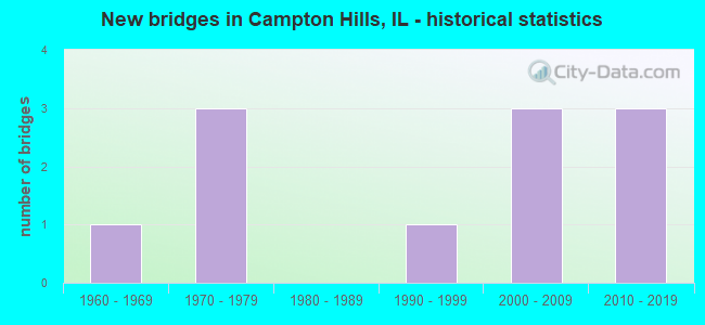
- New bridges - historical statistics
- 11960-1969
- 31970-1979
- 11990-1999
- 32000-2009
- 32010-2019


- Bridge Condition - Deck
- 66.7%Good
- 33.3%Poor

- Bridge Condition - Superstructure
- 75.0%Good
- 25.0%Poor

- Bridge Condition - Substructure
- 50.0%Very good
- 25.0%Good
- 25.0%Satisfactory

- Bridge Condition - Channel
- 33.3%Very good
- 22.2%Good
- 33.3%Satisfactory
- 11.1%Fair

- Bridge Condition - Culverts
- 83.3%Good
- 16.7%Fair
Find on map >> Show street view
Structure Number: 450075, Location: 3.5 M E OF IL 47 (Lat: 41.906456, Lng: -88.405306), Route carried "on" structure: State highway 38, Year Built: 1965, Status: Open, Structure Length: 0.67m (2.20ft), Average Daily Traffic: 11,500 (year 2021), Truck Traffic: 12%, Average Future Daily Traffic: 15,440 (year 2032), Design Load: HS 20, Features Intersected: MILL CREEK
Minimum Vertical Clearance: 30+ m (98+ ft), Kilometerpoint: 98.586, Lanes on structure: 2, Base Highway Network: Yes, Owner: State Highway Agency, Approaching Roadway Width: 8.5m (27.9ft), Material/Design: Concrete continuous, Design/Construction: Culvert, Number Of Spans In Main Unit: 2, Length of Maximum Span: 3.3m (10.8ft)
Condition: Channel: Fair, Culverts: Fair, Operating Rating: 54.8 metric tons, Method Used To Determine Operating Rating: Load Factor (LF) rating reported by rating factor (RF) method using MS18 loading, Inventory Rating: 32.7 metric tons, Method Used To Determine Inventory Rating: Load Factor (LF) rating reported by rating factor (RF) method using MS18 loading, Structural Evaluation: Somewhat better than minimum adequacy, Waterway Adequacy: Better than present minimum criteria, Approach Roadway Alignment: Equal to present desirable criteria, Designated Inspection Frequency: Every 24 months, Inspection Date: January 2020
Find on map >> Show street view
Structure Number: 453076, Location: 500' W OF BUNKER RD (Lat: 41.882172, Lng: -88.416081), Route carried "on" structure: County highway , Year Built: 2013, Status: Open, Structure Length: 1.40m (4.59ft), Average Daily Traffic: 6,250 (year 2018), Truck Traffic: 9%, Average Future Daily Traffic: 8,100 (year 2035), Design Load: HS 25 or greater, Features Intersected: TRIBUTARY TO MILL CR, Facility Carried by Structure: KESLINGER ROAD
Minimum Vertical Clearance: 30+ m (98+ ft), Kilometerpoint: 15.337, Lanes on structure: 2, Owner: County Highway Agency, Approaching Roadway Width: 9.1m (29.9ft), Skew: 20 degrees, Material/Design: Concrete, Design/Construction: Slab, Number Of Spans In Main Unit: 1, Length of Maximum Span: 12.8m (42.0ft), Curb-To-Curb Width: 15.8m (51.8ft), Out-to-Out Width: 16.8m (55.1ft)
Condition: Deck: Good, Superstructure: Good, Substructure: Very good, Channel: Very good, Operating Rating: 56.1 metric tons, Method Used To Determine Operating Rating: Load and Resistance Factor Rating (LRFR) rating reported by rating factor(RF) method using HL-93 loadings, Inventory Rating: 43.1 metric tons, Method Used To Determine Inventory Rating: Load and Resistance Factor Rating (LRFR) rating reported by rating factor(RF) method using HL-93 loadings, Structural Evaluation: Better than present minimum criteria, Deck Geometry: Superior to present desirable criteria, Waterway Adequacy: Equal to present minimum criteria, Approach Roadway Alignment: Equal to present desirable criteria, Designated Inspection Frequency: Every 48 months, Inspection Date: October 2019, Deck Structure Type: Concrete Cast-file-Place, Wearing Surface/Protective System: Deck Protection: Epoxy Coated Reinforcing
Find on map >> Show street view
Structure Number: 453078, Location: 250' S OF FAIR OAKS (Lat: 41.957631, Lng: -88.407450), Route carried "on" structure: Other road , Year Built: 2012, Status: Open, Structure Length: 0.86m (2.82ft), Average Daily Traffic: 3,900 (year 2018), Truck Traffic: 5%, Average Future Daily Traffic: 4,200 (year 2032), Design Load: HS 20, Features Intersected: BR OF FERSON CREEK, Facility Carried by Structure: CORRON ROAD
Minimum Vertical Clearance: 30+ m (98+ ft), Kilometerpoint: 6.019, Lanes on structure: 2, Owner: County Highway Agency, Approaching Roadway Width: 9.8m (32.2ft), Material/Design: Concrete, Design/Construction: Culvert, Number Of Spans In Main Unit: 2, Length of Maximum Span: 4.0m (13.1ft), Curb-To-Curb Width: 9.8m (32.2ft), Out-to-Out Width: 12.5m (41.0ft)
Condition: Channel: Good, Culverts: Good, Operating Rating: 81.3 metric tons, Method Used To Determine Operating Rating: Load Factor (LF) rating reported by rating factor (RF) method using MS18 loading, Inventory Rating: 48.6 metric tons, Method Used To Determine Inventory Rating: Load Factor (LF) rating reported by rating factor (RF) method using MS18 loading, Structural Evaluation: Better than present minimum criteria, Deck Geometry: Meets minimum limits, Waterway Adequacy: Equal to present desirable criteria, Approach Roadway Alignment: Equal to present desirable criteria, Designated Inspection Frequency: Every 48 months, Inspection Date: June 2018, Wearing Surface/Protective System: Wearing Surface: Bituminous
Find on map >> Show street view
Structure Number: 453143, Location: 1.3 MI. S OF IL-38 (Lat: 41.887586, Lng: -88.423783), Route carried "on" structure: County highway , Year Built: 1997, Status: Posted for load, Structure Length: 5.23m (17.16ft), Average Daily Traffic: 1,350 (year 2018), Truck Traffic: 3%, Average Future Daily Traffic: 893 (year 2032), Design Load: HS 20, Features Intersected: UP RR, Facility Carried by Structure: HARLEY RD
Minimum Vertical Clearance: 2.74m (8.99ft), Kilometerpoint: 2.044, Lanes on structure: 2, Owner: Town or Township Highway Agency, Approaching Roadway Width: 9.1m (29.9ft), Material/Design: Prestressed concrete, Design/Construction: Box Beam or Girders - Multiple, Number Of Spans In Main Unit: 3, Length of Maximum Span: 20.4m (66.9ft), Curb-To-Curb Width: 9.1m (29.9ft), Out-to-Out Width: 10.1m (33.1ft)
Condition: Deck: Poor, Superstructure: Poor, Substructure: Satisfactory, Operating Rating: 30.5 metric tons, Method Used To Determine Operating Rating: Load Factor (LF) rating reported by rating factor (RF) method using MS18 loading, Inventory Rating: 14.3 metric tons, Method Used To Determine Inventory Rating: Load Factor (LF) rating reported by rating factor (RF) method using MS18 loading, Structural Evaluation: Meets minimum limits, Deck Geometry: Somewhat better than minimum adequacy, Underclear: High priority of corrective action, Approach Roadway Alignment: Equal to present minimum criteria, Bridge Posting: Required (Relationship of Operating Rating to Maximum Legal Load: 30.0 - 39.9% below), Designated Inspection Frequency: Every 24 months, Inspection Date: June 2020, Deck Structure Type: Concrete Precast Panels, Wearing Surface/Protective System: Wearing Surface: Bituminous, Membrane: Built-up
Find on map >> Show street view
Structure Number: 453177, Location: .1 MI S KESLINGER RD (Lat: 41.880997, Lng: -88.392758), Route carried "on" structure: County highway , Year Built: 2008, Status: Open, Structure Length: 1.68m (5.51ft), Average Daily Traffic: 1,500 (year 2018), Truck Traffic: 6%, Average Future Daily Traffic: 255 (year 2032), Design Load: HS 20, Features Intersected: TRIB OF MILL CREEK, Facility Carried by Structure: FRIENDSHIP WAY
Minimum Vertical Clearance: 30+ m (98+ ft), Kilometerpoint: 0.145, Lanes on structure: 2, Owner: Town or Township Highway Agency, Approaching Roadway Width: 9.1m (29.9ft), Material/Design: Concrete, Design/Construction: Culvert, Number Of Spans In Main Unit: 5, Length of Maximum Span: 3.3m (10.8ft), Curb or Sidewalk Widths: Left: 0.0m, Right: 1.5m (4.9ft), Curb-To-Curb Width: 9.1m (29.9ft), Out-to-Out Width: 12.2m (40.0ft)
Condition: Channel: Very good, Culverts: Good, Operating Rating: 55.7 metric tons, Method Used To Determine Operating Rating: Load Factor (LF) rating reported by rating factor (RF) method using MS18 loading, Inventory Rating: 33.4 metric tons, Method Used To Determine Inventory Rating: Load Factor (LF) rating reported by rating factor (RF) method using MS18 loading, Structural Evaluation: Better than present minimum criteria, Deck Geometry: Somewhat better than minimum adequacy, Waterway Adequacy: Equal to present desirable criteria, Approach Roadway Alignment: Equal to present minimum criteria, Designated Inspection Frequency: Every 48 months, Inspection Date: March 2019
Find on map >> Show street view
Structure Number: 455003, Location: 0.65 MI N Bolcum Rd (Lat: 41.956589, Lng: -88.388744), Route carried "on" structure: City street , Year Built: 1972, Status: Open, Structure Length: 0.66m (2.17ft), Average Daily Traffic: 750 (year 2018), Truck Traffic: 4%, Average Future Daily Traffic: 1,531 (year 2032), Design Load: HS 20, Features Intersected: FERSON CREEK, Facility Carried by Structure: DENKER ROAD
Minimum Vertical Clearance: 30+ m (98+ ft), Kilometerpoint: 1.239, Lanes on structure: 2, Owner: City or Municipal Highway Agency, Approaching Roadway Width: 7.6m (24.9ft), Material/Design: Concrete continuous, Design/Construction: Culvert, Number Of Spans In Main Unit: 2, Length of Maximum Span: 3.2m (10.5ft), Curb-To-Curb Width: 9.1m (29.9ft), Out-to-Out Width: 12.8m (42.0ft)
Condition: Channel: Satisfactory, Culverts: Good, Operating Rating: 78.7 metric tons, Method Used To Determine Operating Rating: Load Factor (LF) rating reported by rating factor (RF) method using MS18 loading, Inventory Rating: 47.3 metric tons, Method Used To Determine Inventory Rating: Load Factor (LF) rating reported by rating factor (RF) method using MS18 loading, Structural Evaluation: Better than present minimum criteria, Deck Geometry: Equal to present minimum criteria, Waterway Adequacy: Better than present minimum criteria, Approach Roadway Alignment: Equal to present desirable criteria, Designated Inspection Frequency: Every 48 months, Inspection Date: November 2018, Deck Structure Type: Other
Find on map >> Show street view
Structure Number: 455008, Location: LAFOX & CAMPTON HILL (Lat: 41.914944, Lng: -88.404611), Route carried "on" structure: Other road , Year Built: 1977, Status: Open, Structure Length: 0.79m (2.59ft), Average Daily Traffic: 7,900 (year 2018), Truck Traffic: 5%, Average Future Daily Traffic: 8,677 (year 2032), Design Load: HS 20, Features Intersected: MILL CREEK, Facility Carried by Structure: LAFOX ROAD
Minimum Vertical Clearance: 30+ m (98+ ft), Kilometerpoint: 2.784, Lanes on structure: 2, Base Highway Network: Yes, Owner: County Highway Agency, Approaching Roadway Width: 8.5m (27.9ft), Skew: 3 degrees, Material/Design: Concrete, Design/Construction: Culvert, Number Of Spans In Main Unit: 2, Length of Maximum Span: 3.7m (12.1ft), Curb-To-Curb Width: 11.0m (36.1ft), Out-to-Out Width: 33.9m (111.2ft)
Condition: Channel: Satisfactory, Culverts: Good, Operating Rating: 61.6 metric tons, Method Used To Determine Operating Rating: Load Factor (LF) rating reported by rating factor (RF) method using MS18 loading, Inventory Rating: 36.6 metric tons, Method Used To Determine Inventory Rating: Load Factor (LF) rating reported by rating factor (RF) method using MS18 loading, Structural Evaluation: Better than present minimum criteria, Deck Geometry: Meets minimum limits, Waterway Adequacy: Equal to present desirable criteria, Approach Roadway Alignment: Equal to present desirable criteria, Designated Inspection Frequency: Every 48 months, Inspection Date: April 2021
Find on map >> Show street view
Structure Number: 45501, Location: 0.4 MI N IL RTE 38 (Lat: 41.911931, Lng: -88.406331), Route carried "on" structure: Other road , Year Built: 2014, Status: Open, Structure Length: 1.46m (4.79ft), Average Daily Traffic: 7,900 (year 2018), Truck Traffic: 5%, Average Future Daily Traffic: 5,933 (year 2032), Design Load: HS 25 or greater, Features Intersected: MILL CREEK, Facility Carried by Structure: LAFOX ROAD
Minimum Vertical Clearance: 30+ m (98+ ft), Kilometerpoint: 3.122, Lanes on structure: 2, Base Highway Network: Yes, Owner: County Highway Agency, Approaching Roadway Width: 11.0m (36.1ft), Material/Design: Prestressed concrete, Design/Construction: Box Beam or Girders - Multiple, Number Of Spans In Main Unit: 1, Length of Maximum Span: 13.7m (44.9ft), Curb-To-Curb Width: 11.0m (36.1ft), Out-to-Out Width: 11.0m (36.1ft)
Condition: Deck: Good, Superstructure: Good, Substructure: Very good, Channel: Good, Operating Rating: 53.1 metric tons, Method Used To Determine Operating Rating: Load and Resistance Factor Rating (LRFR) rating reported by rating factor(RF) method using HL-93 loadings, Inventory Rating: 41.8 metric tons, Method Used To Determine Inventory Rating: Load and Resistance Factor Rating (LRFR) rating reported by rating factor(RF) method using HL-93 loadings, Structural Evaluation: Better than present minimum criteria, Deck Geometry: Meets minimum limits, Waterway Adequacy: Equal to present desirable criteria, Approach Roadway Alignment: Equal to present desirable criteria, Designated Inspection Frequency: Every 48 months, Inspection Date: May 2020, Deck Structure Type: Concrete Precast Panels, Wearing Surface/Protective System: Wearing Surface: Integral Concrete, Deck Protection: Epoxy Coated Reinforcing
Find on map >> Show street view
Structure Number: 45553, Location: .3M W OF BRUNDIGE RD (Lat: 41.882542, Lng: -88.390500), Route carried "on" structure: County highway , Year Built: 2009, Status: Open, Structure Length: 0.91m (2.99ft), Average Daily Traffic: 7,000 (year 2018), Truck Traffic: 4%, Average Future Daily Traffic: 7,018 (year 2032), Design Load: HS 20, Features Intersected: LAFOX TRIB MILL CRK, Facility Carried by Structure: KESLINGER ROAD
Minimum Vertical Clearance: 30+ m (98+ ft), Kilometerpoint: 17.574, Lanes on structure: 2, Base Highway Network: Yes, Owner: County Highway Agency, Approaching Roadway Width: 11.0m (36.1ft), Material/Design: Concrete, Design/Construction: Frame, Number Of Spans In Main Unit: 1, Length of Maximum Span: 8.8m (28.9ft), Curb-To-Curb Width: 15.2m (49.9ft), Out-to-Out Width: 15.2m (49.9ft)
Condition: Superstructure: Good, Substructure: Good, Channel: Very good, Operating Rating: 53.8 metric tons, Method Used To Determine Operating Rating: Load Factor (LF) rating reported by rating factor (RF) method using MS18 loading, Inventory Rating: 32.4 metric tons, Method Used To Determine Inventory Rating: Load Factor (LF) rating reported by rating factor (RF) method using MS18 loading, Structural Evaluation: Better than present minimum criteria, Deck Geometry: Superior to present desirable criteria, Waterway Adequacy: Equal to present desirable criteria, Approach Roadway Alignment: Equal to present desirable criteria, Designated Inspection Frequency: Every 24 months, Inspection Date: March 2021, Deck Structure Type: Other, Wearing Surface/Protective System: Wearing Surface: Bituminous, Deck Protection: Epoxy Coated Reinforcing
Find on map >> Show street view
Structure Number: 45604, Location: 0.1 MI E CORRON RD. (Lat: 41.955756, Lng: -88.405903), Route carried "on" structure: City street , Year Built: 1975, Status: Open, Structure Length: 0.62m (2.03ft), Average Daily Traffic: 250 (year 2018), Truck Traffic: 2%, Average Future Daily Traffic: 350 (year 2042), Features Intersected: TRIB TO FERSON CREEK, Facility Carried by Structure: WINCHESTER WAY
Minimum Vertical Clearance: 30+ m (98+ ft), Kilometerpoint: 0.161, Lanes on structure: 2, Owner: City or Municipal Highway Agency, Approaching Roadway Width: 6.7m (22.0ft), Material/Design: Concrete, Design/Construction: Culvert, Number Of Spans In Main Unit: 2, Length of Maximum Span: 3.0m (9.8ft), Curb-To-Curb Width: 6.7m (22.0ft), Out-to-Out Width: 12.9m (42.3ft)
Condition: Channel: Satisfactory, Culverts: Good, Operating Rating: 53.8 metric tons, Method Used To Determine Operating Rating: Field evaluation and documented engineering judgment, Inventory Rating: 32.4 metric tons, Method Used To Determine Inventory Rating: Field evaluation and documented engineering judgment, Structural Evaluation: Better than present minimum criteria, Deck Geometry: Meets minimum limits, Waterway Adequacy: Equal to present minimum criteria, Approach Roadway Alignment: Equal to present desirable criteria, Designated Inspection Frequency: Every 48 months, Inspection Date: September 2020, Deck Structure Type: Concrete Cast-file-Place, Wearing Surface/Protective System: Wearing Surface: Bituminous
Find on map >> Show street view
Structure Number: 453156, Location: 0.3 MI N. KESLINGER (Lat: 41.885442, Lng: -88.412694), Route carried "under" structure: Other road , Year Built: 2005, Structure Length: 0. m, Average Daily Traffic: 650 (year 2018), Truck Traffic: 3%, Features Intersected: BUNKER ROAD, Facility Carried by Structure: UNION PACIFIC RR
Minimum Vertical Clearance: 30+ m (98+ ft), Kilometerpoint: 0.048, Lanes under structure: 2, Material/Design: Steel, Design/Construction: Stringer/Multi-beam, Length of Maximum Span: 23.9m (78.4ft)