Bridge Statistics for Camptown, Virginia (VA)
Condition, Traffic, Stress, Structural Evaluation, Project Costs
- National Bridge Inventory (NBI) Statistics
- 14Number of bridges
- 200ft / 61.4mTotal length
- $722,000Total costs
- 14,208Total average daily traffic
- 3,270Total average daily truck traffic
- National Bridge Inventory (NBI) Registered Bridges for Camptown
- No street view available for this location
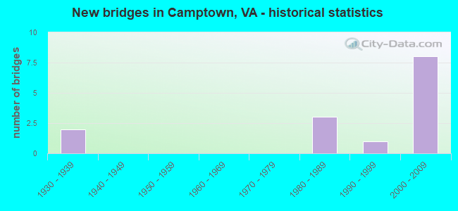
- New bridges - historical statistics
- 21930-1939
- 31980-1989
- 11990-1999
- 82000-2009


- Bridge Condition - Deck
- 18.2%Very good
- 36.4%Good
- 36.4%Satisfactory
- 9.1%Fair

- Bridge Condition - Superstructure
- 45.5%Very good
- 18.2%Good
- 27.3%Satisfactory
- 9.1%Fair

- Bridge Condition - Substructure
- 9.1%Very good
- 63.6%Good
- 18.2%Satisfactory
- 9.1%Fair

- Bridge Condition - Channel
- 30.0%Very good
- 60.0%Good
- 10.0%Satisfactory
Find on map >> Show street view
Structure Number: 10373, Location: 1.7 MI.FR.SUFFOLK LINE (Lat: 36.676236, Lng: -76.901425), Route carried "on" structure: County highway 656, Year Built: 1986, Status: Open, Structure Length: 2.82m (9.25ft), Average Daily Traffic: 2,454 (year 2020), Truck Traffic: 34%, Average Future Daily Traffic: 2,699 (year 2040), Design Load: HS 20+Mod, Features Intersected: Beaverdam Swamp, Facility Carried by Structure: Union Camp Drive
Minimum Vertical Clearance: 30+ m (98+ ft), Kilometerpoint: 3.937, Lanes on structure: 2, Owner: State Highway Agency, Approaching Roadway Width: 7.3m (24.0ft), Material/Design: Prestressed concrete, Design/Construction: Slab, Number Of Spans In Main Unit: 2, Length of Maximum Span: 13.8m (45.3ft), Curb-To-Curb Width: 8.7m (28.5ft), Out-to-Out Width: 9.7m (31.8ft)
Condition: Deck: Satisfactory, Superstructure: Satisfactory, Substructure: Good, Channel: Good, Operating Rating: 76.7 metric tons, Method Used To Determine Operating Rating: Load and Resistance Factor (LRFR), Inventory Rating: 59.1 metric tons, Method Used To Determine Inventory Rating: Load and Resistance Factor (LRFR), Structural Evaluation: Equal to present minimum criteria, Deck Geometry: Meets minimum limits, Waterway Adequacy: Better than present minimum criteria, Approach Roadway Alignment: Equal to present desirable criteria, Designated Inspection Frequency: Every 24 months, Inspection Date: Febuary 2022, Deck Structure Type: Concrete Precast Panels, Wearing Surface/Protective System: Wearing Surface: Bituminous, Membrane: Epoxy
Find on map >> Show street view
Structure Number: 10388, Location: 2.45 Miles from Route 258 (Lat: 36.733653, Lng: -76.917197), Route carried "on" structure: County highway 611, Year Built: 1984, Status: Open, Structure Length: 6.41m (21.03ft), Average Daily Traffic: 1,261 (year 2018), Average Future Daily Traffic: 1,717 (year 2040), Design Load: HS 20+Mod, Features Intersected: Blackwater River, Facility Carried by Structure: Joyners Bridge Rd
Minimum Vertical Clearance: 30+ m (98+ ft), Kilometerpoint: 15.754, Lanes on structure: 2, Owner: State Highway Agency, Approaching Roadway Width: 6.7m (22.0ft), Material/Design: Prestressed concrete, Design/Construction: Stringer/Multi-beam, Number Of Spans In Main Unit: 4, Length of Maximum Span: 15.9m (52.2ft), Curb-To-Curb Width: 8.7m (28.5ft), Out-to-Out Width: 9.7m (31.8ft)
Condition: Deck: Satisfactory, Superstructure: Satisfactory, Substructure: Satisfactory, Channel: Satisfactory, Operating Rating: 78.0 metric tons, Method Used To Determine Operating Rating: Load and Resistance Factor (LRFR), Inventory Rating: 49.0 metric tons, Method Used To Determine Inventory Rating: Load and Resistance Factor (LRFR), Structural Evaluation: Equal to present minimum criteria, Deck Geometry: Somewhat better than minimum adequacy, Waterway Adequacy: Somewhat better than minimum adequacy, Approach Roadway Alignment: Equal to present desirable criteria, Designated Inspection Frequency: Every 24 months, Underwater Inspection Frequency: Every 60 months, Inspection Date: May 2020, Underwater Inspection Date: April 2020, Deck Structure Type: Concrete Cast-file-Place, Wearing Surface/Protective System: Wearing Surface: Monolithic Concrete, Deck Protection: Epoxy Coated Reinforcing
Find on map >> Show street view
Structure Number: 10397, Location: 1.90 MI.FR.INT.RTE:615 (Lat: 36.679786, Lng: -76.895581), Route carried "on" structure: County highway 616, Year Built: 1982, Status: Open, Structure Length: 3.42m (11.22ft), Average Daily Traffic: 421 (year 2017), Average Future Daily Traffic: 519 (year 2040), Design Load: HS 20+Mod, Features Intersected: Beaverdam Swamp, Facility Carried by Structure: Lees Mill Road
Minimum Vertical Clearance: 30+ m (98+ ft), Kilometerpoint: 2.928, Lanes on structure: 2, Owner: State Highway Agency, Approaching Roadway Width: 7.3m (24.0ft), Skew: 3 degrees, Material/Design: Steel, Design/Construction: Stringer/Multi-beam, Number Of Spans In Main Unit: 2, Length of Maximum Span: 19.8m (65.0ft), Curb-To-Curb Width: 9.1m (29.9ft), Out-to-Out Width: 9.8m (32.2ft)
Condition: Deck: Satisfactory, Superstructure: Satisfactory, Substructure: Good, Channel: Very good, Operating Rating: 75.9 metric tons, Method Used To Determine Operating Rating: Load and Resistance Factor (LRFR), Inventory Rating: 58.6 metric tons, Method Used To Determine Inventory Rating: Load and Resistance Factor (LRFR), Structural Evaluation: Equal to present minimum criteria, Deck Geometry: Equal to present minimum criteria, Waterway Adequacy: Equal to present minimum criteria, Approach Roadway Alignment: Equal to present desirable criteria, Designated Inspection Frequency: Every 24 months, Inspection Date: January 2022, Deck Structure Type: Concrete Cast-file-Place, Wearing Surface/Protective System: Wearing Surface: Epoxy Overlay, Membrane: Epoxy, Deck Protection: Epoxy Coated Reinforcing
Find on map >> Show street view
Structure Number: 10443, Location: 0.03 MI.FR.INT.RTE.58 BUS (Lat: 36.682678, Lng: -76.911817), Route carried "on" structure: County highway 691, Year Built: 1938, Status: Open, Structure Length: 5.46m (17.91ft), Average Daily Traffic: 952 (year 2020), Truck Traffic: 4%, Average Future Daily Traffic: 1,047 (year 2040), Design Load: HS 20+Mod, Features Intersected: CSX & NS Railroad, Facility Carried by Structure: Jamestown Lane
Minimum Vertical Clearance: 30+ m (98+ ft), Kilometerpoint: 1.620, Lanes on structure: 2, Owner: State Highway Agency, Approaching Roadway Width: 6.4m (21.0ft), Skew: 1 degrees, Material/Design: Concrete, Design/Construction: Tee Beam, Number Of Spans In Main Unit: 5, Length of Maximum Span: 10.9m (35.8ft), Curb or Sidewalk Widths: Left: 0.1m (0.3ft), Right: 1.5m (4.9ft), Curb-To-Curb Width: 7.0m (23.0ft), Out-to-Out Width: 9.1m (29.9ft)
Condition: Deck: Fair, Superstructure: Fair, Substructure: Fair, Operating Rating: 39.6 metric tons, Method Used To Determine Operating Rating: Load Factor (LF), Inventory Rating: 23.7 metric tons, Method Used To Determine Inventory Rating: Load Factor (LF), Structural Evaluation: Somewhat better than minimum adequacy, Deck Geometry: Meets minimum limits, Underclear: High priority of replacement, Approach Roadway Alignment: Meets minimum limits, Length Of Structure Improvement: 6.10m (20.01ft), Designated Inspection Frequency: Every 24 months, Inspection Date: Febuary 2022, Bridge Improvement Cost: $340,000, Roadway Improvement Cost: $60,000, Total Project Cost: $410,000, Deck Structure Type: Concrete Cast-file-Place, Wearing Surface/Protective System: Wearing Surface: Epoxy Overlay
Find on map >> Show street view
Structure Number: 17797, Location: 1.40 MI. TO INT. RTE. 635 (Lat: 36.767636, Lng: -76.900658), Route carried "on" structure: County highway 619, Year Built: 1932, Status: Open, Structure Length: 1.16m (3.81ft), Average Daily Traffic: 256 (year 2018), Average Future Daily Traffic: 284 (year 2040), Design Load: HL 93, Features Intersected: Black Creek, Facility Carried by Structure: Burdette Road
Minimum Vertical Clearance: 30+ m (98+ ft), Kilometerpoint: 2.253, Lanes on structure: 2, Owner: State Highway Agency, Approaching Roadway Width: 5.1m (16.7ft), Material/Design: Steel, Design/Construction: Stringer/Multi-beam, Number Of Spans In Main Unit: 1, Length of Maximum Span: 11.6m (38.1ft), Curb-To-Curb Width: 5.8m (19.0ft), Out-to-Out Width: 6.1m (20.0ft)
Condition: Deck: Very good, Superstructure: Very good, Substructure: Satisfactory, Channel: Good, Operating Rating: 70.7 metric tons, Method Used To Determine Operating Rating: Load and Resistance Factor (LRFR), Inventory Rating: 54.5 metric tons, Method Used To Determine Inventory Rating: Load and Resistance Factor (LRFR), Structural Evaluation: Equal to present minimum criteria, Deck Geometry: High priority of corrective action, Waterway Adequacy: Equal to present desirable criteria, Approach Roadway Alignment: Better than present minimum criteria, Length Of Structure Improvement: 1.95m (6.40ft), Designated Inspection Frequency: Every 24 months, Inspection Date: July 2021, Bridge Improvement Cost: $127,000, Roadway Improvement Cost: $20,000, Total Project Cost: $178,000 ( Estimate for 2014), Deck Structure Type: Corrugated Steel, Wearing Surface/Protective System: Wearing Surface: Integral Concrete
Find on map >> Show street view
Structure Number: 246, Location: 0.80 Miles from Route 258 (Lat: 36.709528, Lng: -76.870703), Route carried "on" structure: County highway 630, Year Built: 1996, Status: Open, Structure Length: 1.43m (4.69ft), Average Daily Traffic: 231 (year 2017), Average Future Daily Traffic: 337 (year 2040), Design Load: HS 20+Mod, Features Intersected: Beaverdam Swamp, Facility Carried by Structure: Beaverdam Road
Minimum Vertical Clearance: 30+ m (98+ ft), Kilometerpoint: 0.805, Lanes on structure: 2, Owner: State Highway Agency, Approaching Roadway Width: 6.1m (20.0ft), Material/Design: Prestressed concrete, Design/Construction: Box Beam or Girders - Multiple, Number Of Spans In Main Unit: 1, Length of Maximum Span: 13.7m (44.9ft), Curb-To-Curb Width: 7.5m (24.6ft), Out-to-Out Width: 8.5m (27.9ft)
Condition: Deck: Very good, Superstructure: Good, Substructure: Very good, Channel: Good, Operating Rating: 70.4 metric tons, Method Used To Determine Operating Rating: Load and Resistance Factor (LRFR), Inventory Rating: 54.3 metric tons, Method Used To Determine Inventory Rating: Load and Resistance Factor (LRFR), Structural Evaluation: Better than present minimum criteria, Deck Geometry: Somewhat better than minimum adequacy, Waterway Adequacy: Better than present minimum criteria, Approach Roadway Alignment: Equal to present minimum criteria, Designated Inspection Frequency: Every 24 months, Inspection Date: March 2022, Deck Structure Type: Concrete Cast-file-Place, Wearing Surface/Protective System: Wearing Surface: Bituminous, Membrane: Epoxy
Find on map >> Show street view
Structure Number: 26218, Location: 0.05 MI.FR.SOUTHAMPTON CO (Lat: 36.670658, Lng: -76.910733), Route carried "on" structure: County highway 691, Year Built: 2000, Status: Open, Structure Length: 1.83m (6.00ft), Average Daily Traffic: 952 (year 2014), Truck Traffic: 5%, Average Future Daily Traffic: 1,076 (year 2040), Design Load: HS 20, Features Intersected: Beaverdam Swamp, Facility Carried by Structure: Butler Farm Road
Minimum Vertical Clearance: 30+ m (98+ ft), Kilometerpoint: 1.044, Lanes on structure: 2, Owner: State Highway Agency, Approaching Roadway Width: 6.1m (20.0ft), Material/Design: Steel, Design/Construction: Stringer/Multi-beam, Number Of Spans In Main Unit: 1, Length of Maximum Span: 18.3m (60.0ft), Curb-To-Curb Width: 6.1m (20.0ft), Out-to-Out Width: 6.7m (22.0ft)
Condition: Deck: Satisfactory, Superstructure: Good, Substructure: Good, Channel: Good, Operating Rating: 50.8 metric tons, Method Used To Determine Operating Rating: Load and Resistance Factor (LRFR), Inventory Rating: 39.0 metric tons, Method Used To Determine Inventory Rating: Load and Resistance Factor (LRFR), Structural Evaluation: Better than present minimum criteria, Deck Geometry: High priority of corrective action, Waterway Adequacy: Equal to present desirable criteria, Approach Roadway Alignment: Better than present minimum criteria, Length Of Structure Improvement: 1.83m (6.00ft), Designated Inspection Frequency: Every 24 months, Inspection Date: July 2020, Bridge Improvement Cost: $120,000, Roadway Improvement Cost: $12,000, Total Project Cost: $134,000 ( Estimate for 2017), Deck Structure Type: Wood or Timber, Wearing Surface/Protective System: Wearing Surface: Bituminous
Find on map >> Show street view
Structure Number: 26637, Location: 2.22 Miles from Route 744 (Lat: 36.681200, Lng: -76.897992), Route carried "on" structure: County highway 616, Year Built: 2001, Status: Open, Structure Length: 0.63m (2.07ft), Average Daily Traffic: 421 (year 2017), Average Future Daily Traffic: 519 (year 2040), Design Load: HS 20+Mod, Features Intersected: Trib Beaverdam Swamp, Facility Carried by Structure: Lees Mill Road
Minimum Vertical Clearance: 30+ m (98+ ft), Kilometerpoint: 3.250, Lanes on structure: 2, Owner: State Highway Agency, Approaching Roadway Width: 6.4m (21.0ft), Skew: 3 degrees, Material/Design: Concrete, Design/Construction: Culvert, Number Of Spans In Main Unit: 2, Length of Maximum Span: 2.4m (7.9ft)
Condition: Channel: Good, Culverts: Satisfactory, Operating Rating: 69.9 metric tons, Method Used To Determine Operating Rating: Load Factor (LF), Inventory Rating: 41.7 metric tons, Method Used To Determine Inventory Rating: Load Factor (LF), Structural Evaluation: Equal to present minimum criteria, Waterway Adequacy: Equal to present minimum criteria, Approach Roadway Alignment: Equal to present minimum criteria, Designated Inspection Frequency: Every 24 months, Inspection Date: December 2020
Find on map >> Show street view
Structure Number: 2664, Location: 01.18 TO_RTE 58 BUSINESS (Lat: 36.674861, Lng: -76.898156), Route carried "on" structure: State highway 258, Year Built: 2002, Status: Open, Structure Length: 10.06m (33.01ft), Average Daily Traffic: 1,232 (year 2020), Truck Traffic: 38%, Average Future Daily Traffic: 1,355 (year 2040), Design Load: HS 20+Mod, Features Intersected: Beaverdam Swamp, Facility Carried by Structure: Camp Family Hwy
Minimum Vertical Clearance: 30+ m (98+ ft), Kilometerpoint: 0.000, Lanes on structure: 2, Base Highway Network: Yes, Owner: State Highway Agency, Approaching Roadway Width: 11.9m (39.0ft), Material/Design: Prestressed concrete continuous, Design/Construction: Stringer/Multi-beam, Number Of Spans In Main Unit: 5, Length of Maximum Span: 20.0m (65.6ft), Curb-To-Curb Width: 16.8m (55.1ft), Out-to-Out Width: 17.7m (58.1ft)
Condition: Deck: Good, Superstructure: Very good, Substructure: Good, Channel: Very good, Operating Rating: 67.1 metric tons, Method Used To Determine Operating Rating: Load and Resistance Factor (LRFR), Inventory Rating: 51.7 metric tons, Method Used To Determine Inventory Rating: Load and Resistance Factor (LRFR), Structural Evaluation: Better than present minimum criteria, Deck Geometry: Superior to present desirable criteria, Waterway Adequacy: Equal to present desirable criteria, Approach Roadway Alignment: Equal to present desirable criteria, Designated Inspection Frequency: Every 24 months, Inspection Date: Febuary 2021, Deck Structure Type: Concrete Cast-file-Place, Wearing Surface/Protective System: Wearing Surface: Monolithic Concrete, Deck Protection: Epoxy Coated Reinforcing
Find on map >> Show street view
Structure Number: 26643, Location: 1.06MI TO RTE 58 BUSINESS (Lat: 36.676672, Lng: -76.898281), Route carried "on" structure: State highway 258, Year Built: 2002, Status: Open, Structure Length: 15.66m (51.38ft), Average Daily Traffic: 1,232 (year 2020), Truck Traffic: 38%, Average Future Daily Traffic: 1,355 (year 2040), Design Load: HS 20+Mod, Features Intersected: Beaverdam Swamp, Facility Carried by Structure: Camp Family Hwy
Minimum Vertical Clearance: 30+ m (98+ ft), Kilometerpoint: 0.000, Lanes on structure: 2, Base Highway Network: Yes, Owner: State Highway Agency, Approaching Roadway Width: 7.3m (24.0ft), Material/Design: Prestressed concrete continuous, Design/Construction: Stringer/Multi-beam, Number Of Spans In Main Unit: 8, Length of Maximum Span: 19.5m (64.0ft), Curb-To-Curb Width: 13.1m (43.0ft), Out-to-Out Width: 14.2m (46.6ft)
Condition: Deck: Good, Superstructure: Very good, Substructure: Good, Channel: Very good, Operating Rating: 85.3 metric tons, Method Used To Determine Operating Rating: Load and Resistance Factor (LRFR), Inventory Rating: 65.3 metric tons, Method Used To Determine Inventory Rating: Load and Resistance Factor (LRFR), Structural Evaluation: Better than present minimum criteria, Deck Geometry: Better than present minimum criteria, Waterway Adequacy: Equal to present desirable criteria, Approach Roadway Alignment: Equal to present desirable criteria, Designated Inspection Frequency: Every 24 months, Inspection Date: Febuary 2021, Deck Structure Type: Concrete Cast-file-Place, Wearing Surface/Protective System: Wearing Surface: Monolithic Concrete, Deck Protection: Epoxy Coated Reinforcing
Find on map >> Show street view
Structure Number: 26649, Location: 0.87 Miles to Route 58 (Lat: 36.679456, Lng: -76.898431), Route carried "on" structure: State highway 258, Year Built: 2001, Status: Open, Structure Length: 6.10m (20.01ft), Average Daily Traffic: 1,232 (year 2020), Truck Traffic: 38%, Average Future Daily Traffic: 1,355 (year 2040), Design Load: HS 20+Mod, Features Intersected: NS Railroad, Facility Carried by Structure: Camp Family Hwy
Minimum Vertical Clearance: 30+ m (98+ ft), Kilometerpoint: 0.000, Lanes on structure: 2, Owner: State Highway Agency, Approaching Roadway Width: 12.2m (40.0ft), Skew: 3 degrees, Material/Design: Steel continuous, Design/Construction: Stringer/Multi-beam, Number Of Spans In Main Unit: 3, Length of Maximum Span: 23.2m (76.1ft), Curb-To-Curb Width: 13.2m (43.3ft), Out-to-Out Width: 14.2m (46.6ft)
Condition: Deck: Good, Superstructure: Very good, Substructure: Good, Operating Rating: 89.8 metric tons, Method Used To Determine Operating Rating: Load and Resistance Factor (LRFR), Inventory Rating: 84.4 metric tons, Method Used To Determine Inventory Rating: Load and Resistance Factor (LRFR), Structural Evaluation: Better than present minimum criteria, Deck Geometry: Better than present minimum criteria, Underclear: Superior to present desirable criteria, Approach Roadway Alignment: Equal to present desirable criteria, Designated Inspection Frequency: Every 24 months, Inspection Date: Febuary 2021, Deck Structure Type: Concrete Cast-file-Place, Wearing Surface/Protective System: Wearing Surface: Monolithic Concrete, Deck Protection: Epoxy Coated Reinforcing
Find on map >> Show street view
Structure Number: 2665, Location: 0.40 Miles from Route 656 (Lat: 36.680572, Lng: -76.898519), Route carried "on" structure: State highway 258, Year Built: 2003, Status: Open, Structure Length: 0.64m (2.10ft), Average Daily Traffic: 1,232 (year 2020), Truck Traffic: 38%, Average Future Daily Traffic: 1,355 (year 2040), Design Load: HS 20+Mod, Features Intersected: Trib Beaverdam Swamp, Facility Carried by Structure: Franklin Bypass
Minimum Vertical Clearance: 30+ m (98+ ft), Kilometerpoint: 0.000, Lanes on structure: 2, Owner: State Highway Agency, Approaching Roadway Width: 13.1m (43.0ft), Material/Design: Concrete, Design/Construction: Culvert, Number Of Spans In Main Unit: 2, Length of Maximum Span: 3.0m (9.8ft)
Condition: Channel: Good, Culverts: Satisfactory, Operating Rating: 89.8 metric tons, Method Used To Determine Operating Rating: Load Factor (LF), Inventory Rating: 89.8 metric tons, Method Used To Determine Inventory Rating: Load Factor (LF), Structural Evaluation: Equal to present minimum criteria, Waterway Adequacy: Equal to present desirable criteria, Approach Roadway Alignment: Equal to present desirable criteria, Designated Inspection Frequency: Every 24 months, Inspection Date: December 2020
Find on map >> Show street view
Structure Number: 26651, Location: 00.75 TO RTE. 58 BUSINESS (Lat: 36.681394, Lng: -76.898603), Route carried "on" structure: US 258, Year Built: 2002, Status: Open, Structure Length: 5.76m (18.90ft), Average Daily Traffic: 1,232 (year 2020), Truck Traffic: 38%, Average Future Daily Traffic: 1,355 (year 2040), Design Load: HS 20+Mod, Features Intersected: Lee's Mill Road, Facility Carried by Structure: Camp Family Hwy
Minimum Vertical Clearance: 30+ m (98+ ft), Kilometerpoint: 0.000, Lanes on structure: 2, Lanes under structure: 2, Base Highway Network: Yes, Owner: State Highway Agency, Approaching Roadway Width: 7.3m (24.0ft), Skew: 4 degrees, Material/Design: Steel, Design/Construction: Stringer/Multi-beam, Number Of Spans In Main Unit: 3, Length of Maximum Span: 25.6m (84.0ft), Curb-To-Curb Width: 13.2m (43.3ft), Out-to-Out Width: 14.2m (46.6ft)
Condition: Deck: Good, Superstructure: Very good, Substructure: Good, Operating Rating: 89.8 metric tons, Method Used To Determine Operating Rating: Load and Resistance Factor (LRFR), Inventory Rating: 79.8 metric tons, Method Used To Determine Inventory Rating: Load and Resistance Factor (LRFR), Structural Evaluation: Better than present minimum criteria, Deck Geometry: Better than present minimum criteria, Underclear: Meets minimum limits, Approach Roadway Alignment: Equal to present desirable criteria, Designated Inspection Frequency: Every 24 months, Inspection Date: Febuary 2021, Deck Structure Type: Concrete Cast-file-Place, Wearing Surface/Protective System: Wearing Surface: Monolithic Concrete, Deck Protection: Epoxy Coated Reinforcing
Find on map >> Show street view
Structure Number: 26651, Location: 00.75 TO RTE. 58 BUSINESS (Lat: 36.681394, Lng: -76.898603), Route carried "under" structure: Alternate County highway 616, Year Built: 2002, Structure Length: 0. m, Average Daily Traffic: 1,100 (year 2012), Truck Traffic: 1%, Features Intersected: Lee's Mill Road, Facility Carried by Structure: Camp Family Hwy
Minimum Vertical Clearance: 7.09m (23.26ft), Kilometerpoint: 0.000, Lanes on structure: 2, Lanes under structure: 2, Material/Design: Steel, Design/Construction: Stringer/Multi-beam, Length of Maximum Span: 25.6m (84.0ft)