Bridge Statistics for Canaan, New York (NY)
Condition, Traffic, Stress, Structural Evaluation, Project Costs
- National Bridge Inventory (NBI) Statistics
- 24Number of bridges
- 246ft / 74.9mTotal length
- $60,334,000Total costs
- 141,378Total average daily traffic
- 16,411Total average daily truck traffic
- National Bridge Inventory (NBI) Registered Bridges for Canaan
- No street view available for this location
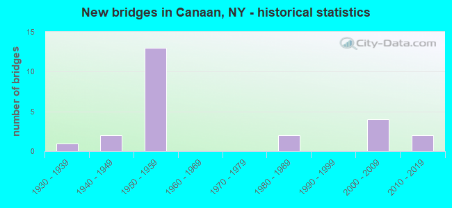
- New bridges - historical statistics
- 11930-1939
- 21940-1949
- 131950-1959
- 21980-1989
- 42000-2009
- 22010-2019


- Bridge Condition - Deck
- 7.1%Very good
- 42.9%Good
- 28.6%Satisfactory
- 21.4%Fair

- Bridge Condition - Superstructure
- 14.3%Excellent
- 14.3%Very good
- 28.6%Good
- 28.6%Satisfactory
- 14.3%Fair

- Bridge Condition - Substructure
- 7.1%Excellent
- 28.6%Very good
- 14.3%Good
- 35.7%Satisfactory
- 14.3%Fair

- Bridge Condition - Channel
- 12.5%Very good
- 18.8%Good
- 50.0%Satisfactory
- 12.5%Fair
- 6.3%Poor

- Bridge Condition - Culverts
- 66.7%Good
- 33.3%Satisfactory
Find on map >> Show street view
Structure Number: 101686, Location: JCT RTE 22+I90 INTC B3 (Lat: 42.358108, Lng: -73.427303), Route carried "on" structure: State highway 22, Year Built: 1957, Status: Open, Structure Length: 15.73m (51.61ft), Average Daily Traffic: 3,059 (year 2019), Truck Traffic: 14%, Average Future Daily Traffic: 3,088 (year 2040), Design Load: HS 20, Features Intersected: 90IX WB, RTE I90
Minimum Vertical Clearance: 30+ m (98+ ft), Kilometerpoint: 46.548, Lanes on structure: 3, Lanes under structure: 5, Base Highway Network: Yes, Owner: State Toll Authority, Approaching Roadway Width: 13.7m (44.9ft), Skew: 5 degrees, Material/Design: Steel, Design/Construction: Stringer/Multi-beam, Number Of Spans In Main Unit: 5, Length of Maximum Span: 39.6m (129.9ft), Curb-To-Curb Width: 13.7m (44.9ft), Out-to-Out Width: 15.8m (51.8ft)
Condition: Deck: Good, Superstructure: Satisfactory, Substructure: Fair, Operating Rating: 57.3 metric tons, Method Used To Determine Operating Rating: Load and Resistance Factor Rating (LRFR) rating reported by rating factor(RF) method using HL-93 loadings, Inventory Rating: 44.1 metric tons, Method Used To Determine Inventory Rating: Load and Resistance Factor Rating (LRFR) rating reported by rating factor(RF) method using HL-93 loadings, Structural Evaluation: Somewhat better than minimum adequacy, Deck Geometry: Somewhat better than minimum adequacy, Underclear: High priority of corrective action, Approach Roadway Alignment: Equal to present desirable criteria, Length Of Structure Improvement: 15.72m (51.57ft), Designated Inspection Frequency: Every 24 months, Inspection Date: August 2021, Bridge Improvement Cost: $9,653,000, Roadway Improvement Cost: $5,653,000, Total Project Cost: $15,305,000 ( Estimate for 2021), Deck Structure Type: Concrete Cast-file-Place, Wearing Surface/Protective System: Wearing Surface: Bituminous
Find on map >> Show street view
Structure Number: 101687, Location: 1.1 MI N JCT SH 22 & I90 (Lat: 42.373631, Lng: -73.429939), Route carried "on" structure: State highway 22, Year Built: 2003, Status: Open, Structure Length: 12.19m (39.99ft), Average Daily Traffic: 3,059 (year 2019), Truck Traffic: 13%, Average Future Daily Traffic: 3,088 (year 2040), Design Load: HS 25 or greater, Features Intersected: Flat Brook, CSX TRANSPOR
Minimum Vertical Clearance: 30+ m (98+ ft), Kilometerpoint: 48.431, Lanes on structure: 2, Base Highway Network: Yes, Owner: State Highway Agency, Approaching Roadway Width: 10.1m (33.1ft), Skew: 5 degrees, Material/Design: Steel continuous, Design/Construction: Stringer/Multi-beam, Number Of Spans In Main Unit: 3, Length of Maximum Span: 45.9m (150.6ft), Curb-To-Curb Width: 12.1m (39.7ft), Out-to-Out Width: 13.1m (43.0ft)
Condition: Deck: Good, Superstructure: Very good, Substructure: Very good, Channel: Satisfactory, Inventory Rating: 63.5 metric tons, Method Used To Determine Inventory Rating: Load Factor (LF), Structural Evaluation: Equal to present desirable criteria, Deck Geometry: Somewhat better than minimum adequacy, Underclear: Somewhat better than minimum adequacy, Waterway Adequacy: Superior to present desirable criteria, Approach Roadway Alignment: Equal to present desirable criteria, Length Of Structure Improvement: 12.19m (39.99ft), Designated Inspection Frequency: Every 24 months, Inspection Date: July 2021, Bridge Improvement Cost: $7,103,000, Roadway Improvement Cost: $4,160,000, Total Project Cost: $11,263,000 ( Estimate for 2021), Deck Structure Type: Concrete Cast-file-Place, Wearing Surface/Protective System: Wearing Surface: Integral Concrete, Deck Protection: Galvanized Reinforcing
Find on map >> Show street view
Structure Number: 104512, Location: 1 MI E JCT SH 295 & I90 (Lat: 42.415722, Lng: -73.514103), Route carried "on" structure: State highway 295, Year Built: 1949, Status: Open, Structure Length: 0.88m (2.89ft), Average Daily Traffic: 2,373 (year 2016), Truck Traffic: 7%, Average Future Daily Traffic: 2,635 (year 2040), Design Load: H 20, Features Intersected: TRIBUTARY to STONY KILL
Minimum Vertical Clearance: 30+ m (98+ ft), Kilometerpoint: 9.670, Lanes on structure: 2, Base Highway Network: Yes, Owner: State Highway Agency, Approaching Roadway Width: 10.7m (35.1ft), Skew: 3 degrees, Material/Design: Concrete, Design/Construction: Slab, Number Of Spans In Main Unit: 1, Length of Maximum Span: 7.6m (24.9ft), Curb-To-Curb Width: 10.6m (34.8ft), Out-to-Out Width: 11.7m (38.4ft)
Condition: Deck: Good, Superstructure: Good, Substructure: Satisfactory, Channel: Satisfactory, Operating Rating: 68.0 metric tons, Method Used To Determine Operating Rating: Load Factor (LF), Inventory Rating: 40.8 metric tons, Method Used To Determine Inventory Rating: Load Factor (LF), Structural Evaluation: Equal to present minimum criteria, Deck Geometry: Somewhat better than minimum adequacy, Waterway Adequacy: Superior to present desirable criteria, Approach Roadway Alignment: Equal to present desirable criteria, Length Of Structure Improvement: 0.88m (2.89ft), Designated Inspection Frequency: Every 24 months, Inspection Date: November 2021, Bridge Improvement Cost: $565,000, Roadway Improvement Cost: $331,000, Total Project Cost: $896,000 ( Estimate for 2021), Wearing Surface/Protective System: Wearing Surface: Bituminous
Find on map >> Show street view
Structure Number: 104513, Location: 1.2 MI E JCT SH 295 & I90 (Lat: 42.418322, Lng: -73.511047), Route carried "on" structure: State highway 295, Year Built: 2005, Status: Open, Structure Length: 4.48m (14.70ft), Average Daily Traffic: 2,373 (year 2016), Truck Traffic: 7%, Average Future Daily Traffic: 2,635 (year 2040), Design Load: HS 25 or greater, Features Intersected: CSX TRANS/ AMTRAK
Minimum Vertical Clearance: 30+ m (98+ ft), Kilometerpoint: 10.008, Lanes on structure: 2, Base Highway Network: Yes, Owner: State Highway Agency, Approaching Roadway Width: 11.9m (39.0ft), Skew: 6 degrees, Material/Design: Steel, Design/Construction: Stringer/Multi-beam, Number Of Spans In Main Unit: 1, Length of Maximum Span: 41.7m (136.8ft), Curb-To-Curb Width: 12.0m (39.4ft), Out-to-Out Width: 12.9m (42.3ft)
Condition: Deck: Satisfactory, Superstructure: Very good, Substructure: Very good, Operating Rating: 84.4 metric tons, Method Used To Determine Operating Rating: Load Factor (LF), Inventory Rating: 50.8 metric tons, Method Used To Determine Inventory Rating: Load Factor (LF), Structural Evaluation: Equal to present desirable criteria, Deck Geometry: Somewhat better than minimum adequacy, Underclear: Somewhat better than minimum adequacy, Approach Roadway Alignment: Equal to present desirable criteria, Length Of Structure Improvement: 4.48m (14.70ft), Designated Inspection Frequency: Every 24 months, Inspection Date: July 2021, Bridge Improvement Cost: $2,745,000, Roadway Improvement Cost: $1,607,000, Total Project Cost: $4,352,000 ( Estimate for 2021), Deck Structure Type: Concrete Cast-file-Place, Wearing Surface/Protective System: Wearing Surface: Integral Concrete, Deck Protection: Epoxy Coated Reinforcing
Find on map >> Show street view
Structure Number: 104514, Location: 2.2 MI W JCT RTS295+22 (Lat: 42.411675, Lng: -73.445758), Route carried "on" structure: State highway 295, Year Built: 1933, Status: Open, Structure Length: 0.91m (2.99ft), Average Daily Traffic: 2,373 (year 2016), Truck Traffic: 7%, Average Future Daily Traffic: 2,635 (year 2040), Features Intersected: STONY KILL
Minimum Vertical Clearance: 30+ m (98+ ft), Kilometerpoint: 15.768, Lanes on structure: 2, Base Highway Network: Yes, Owner: State Highway Agency, Approaching Roadway Width: 8.5m (27.9ft), Skew: 3 degrees, Material/Design: Concrete, Design/Construction: Slab, Number Of Spans In Main Unit: 1, Length of Maximum Span: 7.3m (24.0ft), Curb-To-Curb Width: 8.0m (26.2ft), Out-to-Out Width: 8.8m (28.9ft)
Condition: Deck: Fair, Superstructure: Fair, Substructure: Fair, Channel: Poor, Operating Rating: 65.3 metric tons, Method Used To Determine Operating Rating: Load Factor (LF), Inventory Rating: 39.0 metric tons, Method Used To Determine Inventory Rating: Load Factor (LF), Structural Evaluation: Somewhat better than minimum adequacy, Deck Geometry: High priority of corrective action, Waterway Adequacy: Meets minimum limits, Approach Roadway Alignment: Equal to present desirable criteria, Length Of Structure Improvement: 0.91m (2.99ft), Designated Inspection Frequency: Every 24 months, Inspection Date: November 2021, Bridge Improvement Cost: $386,000, Roadway Improvement Cost: $226,000, Total Project Cost: $612,000 ( Estimate for 2021), Wearing Surface/Protective System: Wearing Surface: Bituminous
Find on map >> Show street view
Structure Number: 105036, Location: .8 MI E I90 INT B3 (Lat: 42.350053, Lng: -73.414825), Route carried "on" structure: State highway 980D, Year Built: 2008, Status: Open, Structure Length: 9.78m (32.09ft), Average Daily Traffic: 1,602 (year 2016), Truck Traffic: 8%, Average Future Daily Traffic: 1,779 (year 2040), Design Load: HS 25 or greater, Features Intersected: 90IX WB, RTE I90, Flat B
Minimum Vertical Clearance: 30+ m (98+ ft), Kilometerpoint: 0.016, Lanes on structure: 2, Lanes under structure: 4, Base Highway Network: Yes, Owner: State Toll Authority, Approaching Roadway Width: 10.7m (35.1ft), Skew: 2 degrees, Material/Design: Steel continuous, Design/Construction: Stringer/Multi-beam, Number Of Spans In Main Unit: 2, Length of Maximum Span: 52.1m (170.9ft), Curb-To-Curb Width: 10.8m (35.4ft), Out-to-Out Width: 11.9m (39.0ft)
Condition: Deck: Very good, Superstructure: Excellent, Substructure: Excellent, Channel: Very good, Inventory Rating: 40.8 metric tons, Method Used To Determine Inventory Rating: Field evaluation and documented engineering judgment, Structural Evaluation: Superior to present desirable criteria, Deck Geometry: Equal to present minimum criteria, Underclear: Meets minimum limits, Waterway Adequacy: Equal to present minimum criteria, Approach Roadway Alignment: Equal to present desirable criteria, Length Of Structure Improvement: 9.78m (32.09ft), Designated Inspection Frequency: Every 24 months, Inspection Date: November 2020, Bridge Improvement Cost: $5,002,000, Roadway Improvement Cost: $2,929,000, Total Project Cost: $7,931,000 ( Estimate for 2021), Deck Structure Type: Concrete Cast-file-Place, Wearing Surface/Protective System: Wearing Surface: Integral Concrete, Deck Protection: Other Coated Reinforcing
Find on map >> Show street view
Structure Number: 222199, Location: CANAAN (Lat: 42.411614, Lng: -73.446733), Route carried "on" structure: Other road , Year Built: 1981, Status: Open, Structure Length: 0.79m (2.59ft), Average Daily Traffic: 74 (year 2015), Truck Traffic: 8%, Average Future Daily Traffic: 104 (year 2035), Design Load: HS 20, Features Intersected: STONY KILL, Facility Carried by Structure: OLD QUEECHY ROAD
Minimum Vertical Clearance: 30+ m (98+ ft), Kilometerpoint: 0.064, Lanes on structure: 2, Owner: Town or Township Highway Agency, Approaching Roadway Width: 6.4m (21.0ft), Skew: 1 degrees, Material/Design: Concrete, Design/Construction: Slab, Number Of Spans In Main Unit: 1, Length of Maximum Span: 7.0m (23.0ft), Curb-To-Curb Width: 7.7m (25.3ft), Out-to-Out Width: 8.3m (27.2ft)
Condition: Deck: Satisfactory, Superstructure: Satisfactory, Substructure: Satisfactory, Channel: Satisfactory, Operating Rating: 77.0 metric tons, Method Used To Determine Operating Rating: Field evaluation and documented engineering judgment, Inventory Rating: 29.4 metric tons, Method Used To Determine Inventory Rating: Field evaluation and documented engineering judgment, Structural Evaluation: Equal to present minimum criteria, Deck Geometry: Equal to present minimum criteria, Waterway Adequacy: Meets minimum limits, Approach Roadway Alignment: Meets minimum limits, Length Of Structure Improvement: 0.79m (2.59ft), Designated Inspection Frequency: Every 24 months, Inspection Date: September 2021, Bridge Improvement Cost: $323,000, Roadway Improvement Cost: $189,000, Total Project Cost: $512,000 ( Estimate for 2021), Wearing Surface/Protective System: Wearing Surface: Bituminous
Find on map >> Show street view
Structure Number: 22629, Location: 1.0 MI SE OF EAST CHATHAM (Lat: 42.401350, Lng: -73.508925), Route carried "on" structure: Other road , Year Built: 1956, Status: Open, Structure Length: 1.10m (3.61ft), Average Daily Traffic: 457 (year 2015), Truck Traffic: 8%, Average Future Daily Traffic: 640 (year 2035), Design Load: HS 20, Features Intersected: FRISBEE CREEK, Facility Carried by Structure: FRISBEE STREET
Minimum Vertical Clearance: 30+ m (98+ ft), Kilometerpoint: 4.682, Lanes on structure: 2, Owner: County Highway Agency, Approaching Roadway Width: 6.1m (20.0ft), Skew: 3 degrees, Material/Design: Concrete continuous, Design/Construction: Culvert, Number Of Spans In Main Unit: 2, Length of Maximum Span: 5.1m (16.7ft)
Condition: Channel: Satisfactory, Culverts: Satisfactory, Inventory Rating: 69.9 metric tons, Method Used To Determine Inventory Rating: Load Factor (LF), Structural Evaluation: Equal to present minimum criteria, Waterway Adequacy: Superior to present desirable criteria, Approach Roadway Alignment: Better than present minimum criteria, Length Of Structure Improvement: 1.09m (3.58ft), Designated Inspection Frequency: Every 24 months, Inspection Date: September 2021, Bridge Improvement Cost: $189,000, Roadway Improvement Cost: $110,000, Total Project Cost: $299,000 ( Estimate for 2021)
Find on map >> Show street view
Structure Number: 226291, Location: 1.7 MI SE OF EAST CHATHAM (Lat: 42.393242, Lng: -73.497928), Route carried "on" structure: Other road , Year Built: 1988, Status: Open, Structure Length: 1.34m (4.40ft), Average Daily Traffic: 457 (year 2015), Truck Traffic: 8%, Average Future Daily Traffic: 640 (year 2035), Design Load: HS 20, Features Intersected: FRISBEE CREEK, Facility Carried by Structure: FRISBEE STREET
Minimum Vertical Clearance: 30+ m (98+ ft), Kilometerpoint: 3.395, Lanes on structure: 2, Owner: County Highway Agency, Approaching Roadway Width: 7.3m (24.0ft), Skew: 2 degrees, Material/Design: Prestressed concrete, Design/Construction: Box Beam or Girders - Multiple, Number Of Spans In Main Unit: 1, Length of Maximum Span: 12.1m (39.7ft), Curb-To-Curb Width: 8.0m (26.2ft), Out-to-Out Width: 8.8m (28.9ft)
Condition: Deck: Good, Superstructure: Good, Substructure: Good, Channel: Satisfactory, Operating Rating: 75.8 metric tons, Method Used To Determine Operating Rating: Load and Resistance Factor Rating (LRFR) rating reported by rating factor(RF) method using HL-93 loadings, Inventory Rating: 57.0 metric tons, Method Used To Determine Inventory Rating: Load and Resistance Factor Rating (LRFR) rating reported by rating factor(RF) method using HL-93 loadings, Structural Evaluation: Better than present minimum criteria, Deck Geometry: Somewhat better than minimum adequacy, Waterway Adequacy: Meets minimum limits, Approach Roadway Alignment: Meets minimum limits, Length Of Structure Improvement: 1.34m (4.40ft), Designated Inspection Frequency: Every 24 months, Inspection Date: July 2021, Bridge Improvement Cost: $431,000, Roadway Improvement Cost: $252,000, Total Project Cost: $683,000 ( Estimate for 2021), Wearing Surface/Protective System: Wearing Surface: Monolithic Concrete
Find on map >> Show street view
Structure Number: 322197, Location: AT EAST CHATHAM (Lat: 42.409594, Lng: -73.522058), Route carried "on" structure: Other road , Year Built: 1957, Status: Open, Structure Length: 1.95m (6.40ft), Average Daily Traffic: 457 (year 2015), Truck Traffic: 8%, Average Future Daily Traffic: 640 (year 2035), Features Intersected: STONY KILL, Facility Carried by Structure: FRISBEE STREET
Minimum Vertical Clearance: 30+ m (98+ ft), Kilometerpoint: 6.082, Lanes on structure: 2, Owner: County Highway Agency, Approaching Roadway Width: 6.1m (20.0ft), Material/Design: Steel, Design/Construction: Stringer/Multi-beam, Number Of Spans In Main Unit: 1, Length of Maximum Span: 18.8m (61.7ft), Curb-To-Curb Width: 8.7m (28.5ft), Out-to-Out Width: 9.4m (30.8ft)
Condition: Deck: Fair, Superstructure: Satisfactory, Substructure: Satisfactory, Channel: Satisfactory, Operating Rating: 42.6 metric tons, Method Used To Determine Operating Rating: Load Factor (LF), Inventory Rating: 25.4 metric tons, Method Used To Determine Inventory Rating: Load Factor (LF), Structural Evaluation: Equal to present minimum criteria, Deck Geometry: Somewhat better than minimum adequacy, Waterway Adequacy: Somewhat better than minimum adequacy, Approach Roadway Alignment: Equal to present minimum criteria, Length Of Structure Improvement: 1.95m (6.40ft), Designated Inspection Frequency: Every 24 months, Inspection Date: July 2020, Bridge Improvement Cost: $1,092,000, Roadway Improvement Cost: $639,000, Total Project Cost: $1,731,000 ( Estimate for 2021), Deck Structure Type: Concrete Cast-file-Place, Wearing Surface/Protective System: Wearing Surface: Bituminous
Find on map >> Show street view
Structure Number: 322198, Location: 1.6 MI W OF CANAAN (Lat: 42.417053, Lng: -73.477394), Route carried "on" structure: Other road , Year Built: 1947, Status: Open, Structure Length: 1.77m (5.81ft), Average Daily Traffic: 85 (year 2020), Truck Traffic: 8%, Average Future Daily Traffic: 119 (year 2040), Features Intersected: STONY KILL, Facility Carried by Structure: SCHILLNGS CROSSNG
Minimum Vertical Clearance: 30+ m (98+ ft), Kilometerpoint: 0.048, Lanes on structure: 1, Owner: County Highway Agency, Approaching Roadway Width: 4.0m (13.1ft), Skew: 2 degrees, Material/Design: Steel, Design/Construction: Truss - Thru, Number Of Spans In Main Unit: 1, Length of Maximum Span: 16.1m (52.8ft), Curb-To-Curb Width: 4.5m (14.8ft), Out-to-Out Width: 4.8m (15.7ft)
Condition: Deck: Fair, Superstructure: Fair, Substructure: Satisfactory, Channel: Good, Operating Rating: 33.7 metric tons, Method Used To Determine Operating Rating: Load and Resistance Factor Rating (LRFR) rating reported by rating factor(RF) method using HL-93 loadings, Inventory Rating: 26.2 metric tons, Method Used To Determine Inventory Rating: Load and Resistance Factor Rating (LRFR) rating reported by rating factor(RF) method using HL-93 loadings, Structural Evaluation: Somewhat better than minimum adequacy, Deck Geometry: Equal to present minimum criteria, Waterway Adequacy: Somewhat better than minimum adequacy, Approach Roadway Alignment: Meets minimum limits, Length Of Structure Improvement: 1.76m (5.77ft), Designated Inspection Frequency: Every 24 months, Critical Feature Inspection Frequency: Every 24 months, Inspection Date: November 2021, Critical Feature Inspection Date: November 2021, Bridge Improvement Cost: $963,000, Roadway Improvement Cost: $564,000, Total Project Cost: $1,527,000 ( Estimate for 2021), Deck Structure Type: Concrete Cast-file-Place, Wearing Surface/Protective System: Wearing Surface: Integral Concrete
Find on map >> Show street view
Structure Number: 334254, Location: AT CANAAN (Lat: 42.411886, Lng: -73.448631), Route carried "on" structure: County highway , Year Built: 2014, Status: Open, Structure Length: 1.25m (4.10ft), Average Daily Traffic: 515 (year 2020), Truck Traffic: 8%, Average Future Daily Traffic: 721 (year 2040), Design Load: HL 93, Features Intersected: STONY KILL, Facility Carried by Structure: COUNTY ROAD 5
Minimum Vertical Clearance: 30+ m (98+ ft), Kilometerpoint: 3.685, Lanes on structure: 2, Owner: County Highway Agency, Approaching Roadway Width: 6.1m (20.0ft), Material/Design: Prestressed concrete, Design/Construction: Box Beam or Girders - Multiple, Number Of Spans In Main Unit: 1, Length of Maximum Span: 12.2m (40.0ft), Curb-To-Curb Width: 7.3m (24.0ft), Out-to-Out Width: 9.7m (31.8ft)
Condition: Deck: Good, Superstructure: Good, Substructure: Very good, Channel: Satisfactory, Operating Rating: 55.4 metric tons, Method Used To Determine Operating Rating: Load and Resistance Factor Rating (LRFR) rating reported by rating factor(RF) method using HL-93 loadings, Inventory Rating: 39.9 metric tons, Method Used To Determine Inventory Rating: Load and Resistance Factor Rating (LRFR) rating reported by rating factor(RF) method using HL-93 loadings, Structural Evaluation: Better than present minimum criteria, Deck Geometry: Meets minimum limits, Waterway Adequacy: Superior to present desirable criteria, Approach Roadway Alignment: Equal to present minimum criteria, Length Of Structure Improvement: 1.24m (4.07ft), Designated Inspection Frequency: Every 24 months, Inspection Date: October 2020, Bridge Improvement Cost: $311,000, Roadway Improvement Cost: $182,000, Total Project Cost: $493,000 ( Estimate for 2021), Deck Structure Type: Concrete Cast-file-Place, Wearing Surface/Protective System: Wearing Surface: Integral Concrete, Deck Protection: Epoxy Coated Reinforcing
Find on map >> Show street view
Structure Number: 336516, Location: 1.9 MI W OF FLATBROOK (Lat: 42.383775, Lng: -73.464681), Route carried "on" structure: County highway , Year Built: 1956, Status: Open, Structure Length: 0.82m (2.69ft), Average Daily Traffic: 243 (year 2019), Truck Traffic: 3%, Average Future Daily Traffic: 340 (year 2039), Design Load: HS 20+Mod, Features Intersected: FRISBEE CREEK, Facility Carried by Structure: COUNTY ROAD 5
Minimum Vertical Clearance: 30+ m (98+ ft), Kilometerpoint: 3.974, Lanes on structure: 2, Owner: County Highway Agency, Approaching Roadway Width: 7.3m (24.0ft), Material/Design: Concrete continuous, Design/Construction: Culvert, Number Of Spans In Main Unit: 2, Length of Maximum Span: 3.9m (12.8ft)
Condition: Channel: Fair, Culverts: Satisfactory, Operating Rating: 53.5 metric tons, Method Used To Determine Operating Rating: Load Factor (LF), Inventory Rating: 31.8 metric tons, Method Used To Determine Inventory Rating: Load Factor (LF), Structural Evaluation: Equal to present minimum criteria, Waterway Adequacy: Meets minimum limits, Approach Roadway Alignment: Equal to present desirable criteria, Length Of Structure Improvement: 0.82m (2.69ft), Designated Inspection Frequency: Every 24 months, Inspection Date: December 2021, Bridge Improvement Cost: $170,000, Roadway Improvement Cost: $99,000, Total Project Cost: $269,000 ( Estimate for 2021)
Find on map >> Show street view
Structure Number: 337136, Location: 1 MI NE CR9 (Lat: 42.356722, Lng: -73.512814), Route carried "on" structure: County highway , Year Built: 2016, Status: Open, Structure Length: 1.19m (3.90ft), Average Daily Traffic: 226 (year 2019), Truck Traffic: 8%, Average Future Daily Traffic: 316 (year 2039), Design Load: HL 93, Features Intersected: INDIAN CREEK, Facility Carried by Structure: COUNTY ROAD 24
Minimum Vertical Clearance: 32.69m (107.25ft), Kilometerpoint: 1.834, Lanes on structure: 2, Owner: County Highway Agency, Approaching Roadway Width: 8.5m (27.9ft), Skew: 3 degrees, Material/Design: Prestressed concrete, Design/Construction: Box Beam or Girders - Multiple, Number Of Spans In Main Unit: 1, Length of Maximum Span: 11.3m (37.1ft), Curb-To-Curb Width: 7.9m (25.9ft), Out-to-Out Width: 9.3m (30.5ft)
Condition: Deck: Satisfactory, Superstructure: Excellent, Substructure: Very good, Channel: Satisfactory, Operating Rating: 67.1 metric tons, Method Used To Determine Operating Rating: Load and Resistance Factor Rating (LRFR) rating reported by rating factor(RF) method using HL-93 loadings, Inventory Rating: 43.7 metric tons, Method Used To Determine Inventory Rating: Load and Resistance Factor Rating (LRFR) rating reported by rating factor(RF) method using HL-93 loadings, Structural Evaluation: Equal to present desirable criteria, Deck Geometry: Somewhat better than minimum adequacy, Waterway Adequacy: Superior to present desirable criteria, Approach Roadway Alignment: Equal to present minimum criteria, Length Of Structure Improvement: 1.18m (3.87ft), Designated Inspection Frequency: Every 24 months, Inspection Date: April 2021, Bridge Improvement Cost: $386,000, Roadway Improvement Cost: $226,000, Total Project Cost: $612,000 ( Estimate for 2021), Deck Structure Type: Concrete Cast-file-Place, Wearing Surface/Protective System: Wearing Surface: Integral Concrete, Deck Protection: Epoxy Coated Reinforcing
Find on map >> Show street view
Structure Number: 55153, Location: 1.7 MI SE OF EAST CHATHAM (Lat: 42.393400, Lng: -73.500075), Route carried "on" structure: Other road , Year Built: 1957, Status: Open, Structure Length: 8.17m (26.80ft), Average Daily Traffic: 291 (year 2017), Truck Traffic: 8%, Average Future Daily Traffic: 407 (year 2037), Design Load: H 20, Features Intersected: 90IX, RTE I90, Facility Carried by Structure: SAYRE HILL ROAD
Minimum Vertical Clearance: 30+ m (98+ ft), Kilometerpoint: 0.032, Lanes on structure: 2, Lanes under structure: 4, Owner: State Toll Authority, Approaching Roadway Width: 7.3m (24.0ft), Material/Design: Steel, Design/Construction: Stringer/Multi-beam, Number Of Spans In Main Unit: 5, Length of Maximum Span: 17.7m (58.1ft), Curb or Sidewalk Widths: Left: 0.5m (1.6ft), Right: 0.5m (1.6ft), Curb-To-Curb Width: 7.3m (24.0ft), Out-to-Out Width: 9.4m (30.8ft)
Condition: Deck: Good, Superstructure: Satisfactory, Substructure: Good, Operating Rating: 51.2 metric tons, Method Used To Determine Operating Rating: Load and Resistance Factor Rating (LRFR) rating reported by rating factor(RF) method using HL-93 loadings, Inventory Rating: 39.5 metric tons, Method Used To Determine Inventory Rating: Load and Resistance Factor Rating (LRFR) rating reported by rating factor(RF) method using HL-93 loadings, Structural Evaluation: Equal to present minimum criteria, Deck Geometry: Somewhat better than minimum adequacy, Underclear: High priority of corrective action, Approach Roadway Alignment: Equal to present minimum criteria, Length Of Structure Improvement: 8.16m (26.77ft), Designated Inspection Frequency: Every 24 months, Inspection Date: November 2020, Bridge Improvement Cost: $2,847,000, Roadway Improvement Cost: $1,667,000, Total Project Cost: $4,514,000 ( Estimate for 2021), Deck Structure Type: Concrete Cast-file-Place, Wearing Surface/Protective System: Wearing Surface: Bituminous, Membrane: Other
Find on map >> Show street view
Structure Number: 5515311, Location: 1.6 MI.SW OF CANAAN (Lat: 42.389147, Lng: -73.492375), Route carried "on" structure: Interstate 90, Year Built: 1957, Status: Open, Structure Length: 1.01m (3.31ft), Average Daily Traffic: 11,122 (year 2014), Truck Traffic: 20%, Average Future Daily Traffic: 15,570 (year 2034), Design Load: HS 20+Mod, Features Intersected: FRISBEE CREEK
Minimum Vertical Clearance: 30+ m (98+ ft), Kilometerpoint: 1317.417, Lanes on structure: 2, Base Highway Network: Yes, Toll: On Interstate toll segment, Owner: State Toll Authority, Approaching Roadway Width: 14.3m (46.9ft), Skew: 2 degrees, Material/Design: Concrete, Design/Construction: Culvert, Number Of Spans In Main Unit: 2, Length of Maximum Span: 4.2m (13.8ft)
Condition: Channel: Very good, Culverts: Good, Operating Rating: 75.6 metric tons, Method Used To Determine Operating Rating: Field evaluation and documented engineering judgment, Inventory Rating: 32.7 metric tons, Method Used To Determine Inventory Rating: Field evaluation and documented engineering judgment, Structural Evaluation: Better than present minimum criteria, Waterway Adequacy: Superior to present desirable criteria, Approach Roadway Alignment: Equal to present desirable criteria, Length Of Structure Improvement: 1.00m (3.28ft), Designated Inspection Frequency: Every 24 months, Inspection Date: September 2020, Bridge Improvement Cost: $687,000, Roadway Improvement Cost: $402,000, Total Project Cost: $1,090,000 ( Estimate for 2021)
Find on map >> Show street view
Structure Number: 5515312, Location: 1.6 MI SW OF CANAAN (Lat: 42.388719, Lng: -73.492214), Route carried "on" structure: Interstate 90, Year Built: 1957, Status: Open, Structure Length: 1.01m (3.31ft), Average Daily Traffic: 8,372 (year 2020), Truck Traffic: 41%, Average Future Daily Traffic: 14,677 (year 2040), Design Load: HS 20+Mod, Features Intersected: FRISBEE CREEK
Minimum Vertical Clearance: 30+ m (98+ ft), Kilometerpoint: 15.816, Lanes on structure: 2, Base Highway Network: Yes, Toll: On toll road, Owner: State Toll Authority, Approaching Roadway Width: 14.3m (46.9ft), Skew: 2 degrees, Material/Design: Concrete, Design/Construction: Culvert, Number Of Spans In Main Unit: 2, Length of Maximum Span: 4.2m (13.8ft)
Condition: Channel: Good, Culverts: Good, Operating Rating: 75.6 metric tons, Method Used To Determine Operating Rating: Field evaluation and documented engineering judgment, Inventory Rating: 32.7 metric tons, Method Used To Determine Inventory Rating: Field evaluation and documented engineering judgment, Structural Evaluation: Better than present minimum criteria, Waterway Adequacy: Superior to present desirable criteria, Approach Roadway Alignment: Equal to present desirable criteria, Length Of Structure Improvement: 1.00m (3.28ft), Designated Inspection Frequency: Every 24 months, Inspection Date: September 2020, Bridge Improvement Cost: $684,000, Roadway Improvement Cost: $401,000, Total Project Cost: $1,085,000 ( Estimate for 2021), Wearing Surface/Protective System: Wearing Surface: Bituminous
Find on map >> Show street view
Structure Number: 551532, Location: 2.6 M SW OF CANAAN (Lat: 42.388669, Lng: -73.487294), Route carried "on" structure: Interstate 90, Year Built: 1957, Status: Open, Structure Length: 1.07m (3.51ft), Average Daily Traffic: 16,744 (year 2020), Truck Traffic: 41%, Average Future Daily Traffic: 29,353 (year 2040), Design Load: HS 20+Mod, Features Intersected: FRISBEE CREEK
Minimum Vertical Clearance: 30+ m (98+ ft), Kilometerpoint: 16.219, Lanes on structure: 2, Base Highway Network: Yes, Toll: On Interstate toll segment, Owner: State Toll Authority, Approaching Roadway Width: 14.0m (45.9ft), Skew: 3 degrees, Material/Design: Concrete, Design/Construction: Culvert, Number Of Spans In Main Unit: 2, Length of Maximum Span: 4.2m (13.8ft)
Condition: Channel: Good, Culverts: Good, Operating Rating: 75.6 metric tons, Method Used To Determine Operating Rating: Field evaluation and documented engineering judgment, Inventory Rating: 32.7 metric tons, Method Used To Determine Inventory Rating: Field evaluation and documented engineering judgment, Structural Evaluation: Better than present minimum criteria, Waterway Adequacy: Equal to present desirable criteria, Approach Roadway Alignment: Equal to present desirable criteria, Length Of Structure Improvement: 1.06m (3.48ft), Designated Inspection Frequency: Every 24 months, Inspection Date: October 2020, Bridge Improvement Cost: $712,000, Roadway Improvement Cost: $417,000, Total Project Cost: $1,128,000 ( Estimate for 2021), Wearing Surface/Protective System: Wearing Surface: Bituminous
Find on map >> Show street view
Structure Number: 551533, Location: 2.1 M SW OF CANAAN (Lat: 42.385692, Lng: -73.467744), Route carried "on" structure: Interstate 90, Year Built: 1957, Status: Open, Structure Length: 0.79m (2.59ft), Average Daily Traffic: 11,122 (year 2014), Truck Traffic: 20%, Average Future Daily Traffic: 15,571 (year 2034), Design Load: HS 20+Mod, Features Intersected: FRISBEE CREEK
Minimum Vertical Clearance: 30+ m (98+ ft), Kilometerpoint: 1319.525, Lanes on structure: 2, Base Highway Network: Yes, Toll: On Interstate toll segment, Owner: State Toll Authority, Approaching Roadway Width: 12.8m (42.0ft), Material/Design: Concrete, Design/Construction: Culvert, Number Of Spans In Main Unit: 2, Length of Maximum Span: 3.7m (12.1ft)
Condition: Channel: Fair, Culverts: Good, Operating Rating: 75.1 metric tons, Method Used To Determine Operating Rating: Field evaluation and documented engineering judgment, Inventory Rating: 32.7 metric tons, Method Used To Determine Inventory Rating: Field evaluation and documented engineering judgment, Structural Evaluation: Better than present minimum criteria, Waterway Adequacy: Superior to present desirable criteria, Approach Roadway Alignment: Equal to present desirable criteria, Length Of Structure Improvement: 0.79m (2.59ft), Designated Inspection Frequency: Every 24 months, Inspection Date: October 2020, Bridge Improvement Cost: $505,000, Roadway Improvement Cost: $296,000, Total Project Cost: $801,000 ( Estimate for 2021)
Find on map >> Show street view
Structure Number: 551534, Location: 2.2 MI S OF CANAAN (Lat: 42.382853, Lng: -73.466189), Route carried "on" structure: County highway , Year Built: 1957, Status: Open, Structure Length: 8.69m (28.51ft), Average Daily Traffic: 243 (year 2019), Truck Traffic: 3%, Average Future Daily Traffic: 340 (year 2039), Design Load: H 20, Features Intersected: 90IX, RTE I90, Facility Carried by Structure: CR5 RED ROCK ROAD
Minimum Vertical Clearance: 30+ m (98+ ft), Kilometerpoint: 3.797, Lanes on structure: 2, Lanes under structure: 4, Owner: State Toll Authority, Approaching Roadway Width: 7.9m (25.9ft), Skew: 1 degrees, Material/Design: Steel, Design/Construction: Stringer/Multi-beam, Number Of Spans In Main Unit: 5, Length of Maximum Span: 18.9m (62.0ft), Curb or Sidewalk Widths: Left: 0.5m (1.6ft), Right: 0.5m (1.6ft), Curb-To-Curb Width: 7.9m (25.9ft), Out-to-Out Width: 10.1m (33.1ft)
Condition: Deck: Satisfactory, Superstructure: Good, Substructure: Satisfactory, Operating Rating: 53.1 metric tons, Method Used To Determine Operating Rating: Load and Resistance Factor Rating (LRFR) rating reported by rating factor(RF) method using HL-93 loadings, Inventory Rating: 40.8 metric tons, Method Used To Determine Inventory Rating: Load and Resistance Factor Rating (LRFR) rating reported by rating factor(RF) method using HL-93 loadings, Structural Evaluation: Equal to present minimum criteria, Deck Geometry: Somewhat better than minimum adequacy, Underclear: High priority of corrective action, Approach Roadway Alignment: Equal to present minimum criteria, Length Of Structure Improvement: 8.68m (28.48ft), Designated Inspection Frequency: Every 24 months, Inspection Date: November 2020, Bridge Improvement Cost: $3,299,000, Roadway Improvement Cost: $1,932,000, Total Project Cost: $5,231,000 ( Estimate for 2021), Deck Structure Type: Concrete Cast-file-Place, Wearing Surface/Protective System: Wearing Surface: Bituminous, Membrane: Other
Find on map >> Show street view
Structure Number: 101686, Location: JCT RTE 22+I90 INTC B3 (Lat: 42.358108, Lng: -73.427303), Route carried "under" structure: Interstate 90, Year Built: 1957, Structure Length: 0. m, Average Daily Traffic: 10,000 (year 1979), Features Intersected: 90IX WB, RTE I90, Facility Carried by Structure: RTE 22
Minimum Vertical Clearance: 4.62m (15.16ft), Kilometerpoint: 1324.641, Lanes on structure: 3, Lanes under structure: 2, Toll: On toll road, Material/Design: Steel, Design/Construction: Stringer/Multi-beam, Length of Maximum Span: 39.6m (129.9ft)
Find on map >> Show street view
Structure Number: 105036, Location: .8 MI E I90 INT B3 (Lat: 42.350053, Lng: -73.414825), Route carried "under" structure: Spur Interstate 90, Year Built: 2008, Structure Length: 0. m, Average Daily Traffic: 21,747 (year 2012), Features Intersected: 90IX WB, RTE I90, Flat B, Facility Carried by Structure: RTE 980D
Minimum Vertical Clearance: 5.54m (18.18ft), Kilometerpoint: 1325.961, Lanes on structure: 2, Lanes under structure: 2, Toll: On Interstate toll segment, Material/Design: Steel continuous, Design/Construction: Stringer/Multi-beam, Length of Maximum Span: 52.1m (170.9ft)
Find on map >> Show street view
Structure Number: 55153, Location: 1.7 MI SE OF EAST CHATHAM (Lat: 42.393400, Lng: -73.500075), Route carried "under" structure: Interstate 90, Year Built: 1957, Structure Length: 0. m, Average Daily Traffic: 22,243 (year 2014), Features Intersected: 90IX, RTE I90, Facility Carried by Structure: SAYRE HILL ROAD
Minimum Vertical Clearance: 4.42m (14.50ft), Kilometerpoint: 1316.580, Lanes on structure: 2, Lanes under structure: 2, Toll: On Interstate toll segment, Material/Design: Steel, Design/Construction: Stringer/Multi-beam, Length of Maximum Span: 17.7m (58.1ft)
Find on map >> Show street view
Structure Number: 551534, Location: 2.2 MI S OF CANAAN (Lat: 42.382853, Lng: -73.466189), Route carried "under" structure: Interstate 90, Year Built: 1957, Structure Length: 0. m, Average Daily Traffic: 22,141 (year 2015), Features Intersected: 90IX, RTE I90, Facility Carried by Structure: CR5 RED ROCK ROAD
Minimum Vertical Clearance: 4.70m (15.42ft), Kilometerpoint: 1319.847, Lanes on structure: 2, Lanes under structure: 2, Toll: On Interstate toll segment, Material/Design: Steel, Design/Construction: Stringer/Multi-beam, Length of Maximum Span: 18.9m (62.0ft)