Bridge Statistics for Canalou, Missouri (MO)
Condition, Traffic, Stress, Structural Evaluation, Project Costs
- National Bridge Inventory (NBI) Statistics
- 21Number of bridges
- 243ft / 74.5mTotal length
- $2,107,000Total costs
- 136,979Total average daily traffic
- 16,399Total average daily truck traffic
- 231,955Total future (year 2041) average daily traffic
- National Bridge Inventory (NBI) Registered Bridges for Canalou
- No street view available for this location
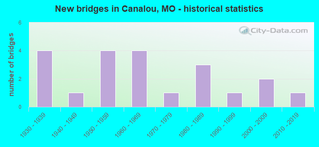
- New bridges - historical statistics
- 41930-1939
- 11940-1949
- 41950-1959
- 41960-1969
- 11970-1979
- 31980-1989
- 11990-1999
- 22000-2009
- 12010-2019

- Reconstructed bridges - Historical Statistics
- 11950-1959
- 01960-1969
- 01970-1979
- 01980-1989
- 01990-1999
- 12000-2009


- Bridge Condition - Deck
- 26.7%Very good
- 26.7%Good
- 20.0%Satisfactory
- 20.0%Fair
- 6.7%Poor

- Bridge Condition - Superstructure
- 6.7%Excellent
- 26.7%Good
- 46.7%Satisfactory
- 20.0%Fair

- Bridge Condition - Substructure
- 13.3%Very good
- 40.0%Good
- 6.7%Satisfactory
- 26.7%Fair
- 13.3%Poor

- Bridge Condition - Channel
- 4.8%Excellent
- 23.8%Good
- 61.9%Satisfactory
- 4.8%Fair
- 4.8%Poor

- Bridge Condition - Culverts
- 16.7%Good
- 50.0%Satisfactory
- 33.3%Fair
Find on map >> Show street view
Structure Number: 18847, Location: S 12 T 24 N R 12 E (Lat: 36.742814, Lng: -89.703019), Route carried "on" structure: County highway 201, Year Built: 1983, Status: Posted for load, Structure Length: 1.92m (6.30ft), Average Daily Traffic: 15 (year 2021), Truck Traffic: 10%, Average Future Daily Traffic: 20 (year 2041), Features Intersected: DRAIN DTCH, Facility Carried by Structure: COUNTY RD 750
Minimum Vertical Clearance: 30+ m (98+ ft), Kilometerpoint: 2.414, Lanes on structure: 1, Owner: County Highway Agency, Approaching Roadway Width: 5.5m (18.0ft), Material/Design: Steel, Design/Construction: Stringer/Multi-beam, Number Of Spans In Main Unit: 1, Number Of Approach Spans: 2, Length of Maximum Span: 10.7m (35.1ft), Curb-To-Curb Width: 4.9m (16.1ft), Out-to-Out Width: 4.9m (16.1ft)
Condition: Deck: Good, Superstructure: Good, Substructure: Good, Channel: Satisfactory, Operating Rating: 22.5 metric tons, Method Used To Determine Operating Rating: Allowable Stress (AS), Inventory Rating: 16.2 metric tons, Method Used To Determine Inventory Rating: Allowable Stress (AS), Structural Evaluation: Somewhat better than minimum adequacy, Deck Geometry: High priority of corrective action, Waterway Adequacy: Better than present minimum criteria, Approach Roadway Alignment: Meets minimum limits, Bridge Posting: Required (Relationship of Operating Rating to Maximum Legal Load: 0.1 - 9.9% below), Length Of Structure Improvement: 0.27m (0.89ft), Designated Inspection Frequency: Every 24 months, Inspection Date: January 2021, Bridge Improvement Cost: $134,000, Roadway Improvement Cost: $13,000, Total Project Cost: $201,000 ( Estimate for 2022), Deck Structure Type: Wood or Timber, Wearing Surface/Protective System: Wearing Surface: Wood or Timber
Find on map >> Show street view
Structure Number: 18865, Location: S 1 T 24 N R 12 E (Lat: 36.757383, Lng: -89.704672), Route carried "on" structure: County highway 202, Year Built: 1995, Status: Open, Structure Length: 3.11m (10.20ft), Average Daily Traffic: 50 (year 2021), Truck Traffic: 10%, Average Future Daily Traffic: 65 (year 2041), Design Load: HS 20, Features Intersected: DRAIN DTCH, Facility Carried by Structure: COUNTY RD 732
Minimum Vertical Clearance: 30+ m (98+ ft), Kilometerpoint: 2.092, Lanes on structure: 2, Owner: Town or Township Highway Agency, Approaching Roadway Width: 7.3m (24.0ft), Skew: 1 degrees, Material/Design: Prestressed concrete, Design/Construction: Box Beam or Girders - Multiple, Number Of Spans In Main Unit: 3, Length of Maximum Span: 12.2m (40.0ft), Curb-To-Curb Width: 7.3m (24.0ft), Out-to-Out Width: 7.3m (24.0ft)
Condition: Deck: Very good, Superstructure: Good, Substructure: Good, Channel: Excellent, Operating Rating: 54.0 metric tons, Method Used To Determine Operating Rating: Load Factor (LF), Inventory Rating: 36.0 metric tons, Method Used To Determine Inventory Rating: Load Factor (LF), Structural Evaluation: Better than present minimum criteria, Deck Geometry: Equal to present minimum criteria, Waterway Adequacy: Superior to present desirable criteria, Approach Roadway Alignment: Equal to present minimum criteria, Designated Inspection Frequency: Every 24 months, Inspection Date: January 2021, Deck Structure Type: Concrete Precast Panels, Wearing Surface/Protective System: Wearing Surface: Bituminous
Find on map >> Show street view
Structure Number: 23509, Location: S 10 T 44 N R 30 W (Lat: 38.617836, Lng: -94.209417), Route carried "on" structure: County highway 411, Year Built: 1965, Status: Open, Structure Length: 1.10m (3.61ft), Average Daily Traffic: 45 (year 2021), Truck Traffic: 5%, Average Future Daily Traffic: 72 (year 2041), Design Load: H 15, Features Intersected: CLEAR CR, Facility Carried by Structure: SYCAMORE GROVE
Minimum Vertical Clearance: 30+ m (98+ ft), Kilometerpoint: 1.770, Lanes on structure: 2, Owner: County Highway Agency, Approaching Roadway Width: 6.1m (20.0ft), Material/Design: Concrete, Design/Construction: Culvert, Number Of Spans In Main Unit: 2, Length of Maximum Span: 5.2m (17.1ft), Curb-To-Curb Width: 8.4m (27.6ft), Out-to-Out Width: 9.0m (29.5ft)
Condition: Channel: Good, Culverts: Satisfactory, Operating Rating: 49.5 metric tons, Method Used To Determine Operating Rating: Allowable Stress (AS), Inventory Rating: 16.2 metric tons, Method Used To Determine Inventory Rating: Allowable Stress (AS), Structural Evaluation: Somewhat better than minimum adequacy, Deck Geometry: Equal to present minimum criteria, Waterway Adequacy: Meets minimum limits, Approach Roadway Alignment: Equal to present minimum criteria, Designated Inspection Frequency: Every 24 months, Inspection Date: April 2021
Find on map >> Show street view
Structure Number: 2352, Location: S 8 T 61 N R 39 W (Lat: 40.111011, Lng: -95.315328), Route carried "on" structure: State highway 118, Year Built: 1972, Status: Open, Structure Length: 6.74m (22.11ft), Average Daily Traffic: 246 (year 2021), Truck Traffic: 22%, Average Future Daily Traffic: 320 (year 2041), Design Load: H 15, Features Intersected: LIT TARKIO CR
Minimum Vertical Clearance: 30+ m (98+ ft), Kilometerpoint: 3.178, Lanes on structure: 2, Owner: State Highway Agency, Approaching Roadway Width: 7.3m (24.0ft), Material/Design: Prestressed concrete continuous, Design/Construction: Stringer/Multi-beam, Number Of Spans In Main Unit: 5, Length of Maximum Span: 13.4m (44.0ft), Curb or Sidewalk Widths: Left: 0.2m (0.7ft), Right: 0.2m (0.7ft), Curb-To-Curb Width: 10.4m (34.1ft), Out-to-Out Width: 11.2m (36.7ft)
Condition: Deck: Good, Superstructure: Satisfactory, Substructure: Fair, Channel: Satisfactory, Operating Rating: 48.6 metric tons, Method Used To Determine Operating Rating: Load Factor (LF), Inventory Rating: 28.8 metric tons, Method Used To Determine Inventory Rating: Load Factor (LF), Structural Evaluation: Somewhat better than minimum adequacy, Deck Geometry: Better than present minimum criteria, Waterway Adequacy: Equal to present desirable criteria, Approach Roadway Alignment: Equal to present desirable criteria, Designated Inspection Frequency: Every 24 months, Inspection Date: November 2021, Deck Structure Type: Concrete Cast-file-Place, Wearing Surface/Protective System: Wearing Surface: Monolithic Concrete
Find on map >> Show street view
Structure Number: 23553, Location: S 26 T 46 N R 13 W (Lat: 38.734833, Lng: -92.356889), Route carried "on" structure: County highway 415, Year Built: 1980, Status: Open, Structure Length: 1.55m (5.09ft), Average Daily Traffic: 50 (year 2021), Truck Traffic: 5%, Average Future Daily Traffic: 95 (year 2041), Design Load: H 20, Features Intersected: GLASCOCK BR, Facility Carried by Structure: CEDAR TREE LANE
Minimum Vertical Clearance: 30+ m (98+ ft), Kilometerpoint: 0.000, Lanes on structure: 1, Owner: County Highway Agency, Approaching Roadway Width: 6.1m (20.0ft), Material/Design: Prestressed concrete, Design/Construction: Tee Beam, Number Of Spans In Main Unit: 1, Length of Maximum Span: 15.2m (49.9ft), Curb-To-Curb Width: 4.9m (16.1ft), Out-to-Out Width: 5.0m (16.4ft)
Condition: Deck: Very good, Superstructure: Good, Substructure: Good, Channel: Satisfactory, Operating Rating: 49.5 metric tons, Method Used To Determine Operating Rating: Allowable Stress (AS), Inventory Rating: 25.2 metric tons, Method Used To Determine Inventory Rating: Allowable Stress (AS), Structural Evaluation: Equal to present minimum criteria, Deck Geometry: High priority of corrective action, Waterway Adequacy: Better than present minimum criteria, Approach Roadway Alignment: Somewhat better than minimum adequacy, Length Of Structure Improvement: 0.22m (0.72ft), Designated Inspection Frequency: Every 24 months, Inspection Date: December 2020, Bridge Improvement Cost: $109,000, Roadway Improvement Cost: $11,000, Total Project Cost: $163,000 ( Estimate for 2022), Deck Structure Type: Concrete Cast-file-Place, Wearing Surface/Protective System: Wearing Surface: Monolithic Concrete
Find on map >> Show street view
Structure Number: 23578, Location: S 14 T 31 N R 29 W (Lat: 37.429481, Lng: -94.093700), Route carried "on" structure: County highway 417, Year Built: 1930, Status: Posted for load, Structure Length: 1.71m (5.61ft), Average Daily Traffic: 10 (year 2021), Truck Traffic: 10%, Average Future Daily Traffic: 14 (year 2041), Features Intersected: N FK SPRING RVR, Facility Carried by Structure: SE 45TH RD
Minimum Vertical Clearance: 30+ m (98+ ft), Kilometerpoint: 0.483, Lanes on structure: 1, Owner: County Highway Agency, Approaching Roadway Width: 4.9m (16.1ft), Material/Design: Steel, Design/Construction: Stringer/Multi-beam, Number Of Spans In Main Unit: 2, Length of Maximum Span: 8.2m (26.9ft), Curb-To-Curb Width: 4.4m (14.4ft), Out-to-Out Width: 4.8m (15.7ft)
Condition: Deck: Poor, Superstructure: Satisfactory, Substructure: Poor, Channel: Poor, Operating Rating: 27.0 metric tons, Method Used To Determine Operating Rating: Allowable Stress (AS), Inventory Rating: 14.4 metric tons, Method Used To Determine Inventory Rating: Allowable Stress (AS), Structural Evaluation: Meets minimum limits, Deck Geometry: Equal to present minimum criteria, Waterway Adequacy: Somewhat better than minimum adequacy, Approach Roadway Alignment: Equal to present minimum criteria, Length Of Structure Improvement: 0.24m (0.79ft), Designated Inspection Frequency: Every 24 months, Inspection Date: March 2021, Bridge Improvement Cost: $175,000, Roadway Improvement Cost: $18,000, Total Project Cost: $263,000 ( Estimate for 2022), Deck Structure Type: Concrete Cast-file-Place, Wearing Surface/Protective System: Wearing Surface: Monolithic Concrete
Find on map >> Show street view
Structure Number: 30956, Location: S 5 T 24 N R 13 E (Lat: 36.743317, Lng: -89.682611), Route carried "on" structure: County highway 19, Year Built: 2004, Status: Open, Structure Length: 0.69m (2.26ft), Average Daily Traffic: 100 (year 2021), Truck Traffic: 10%, Average Future Daily Traffic: 135 (year 2041), Design Load: HS 20, Features Intersected: LATERAL DTCH NO 1, Facility Carried by Structure: COUNTY RD 854
Minimum Vertical Clearance: 30+ m (98+ ft), Kilometerpoint: 0.000, Lanes on structure: 2, Owner: County Highway Agency, Approaching Roadway Width: 7.3m (24.0ft), Material/Design: Concrete continuous, Design/Construction: Culvert, Number Of Spans In Main Unit: 2, Length of Maximum Span: 3.0m (9.8ft)
Condition: Channel: Good, Culverts: Good, Operating Rating: 70.2 metric tons, Method Used To Determine Operating Rating: Load Factor (LF), Inventory Rating: 42.3 metric tons, Method Used To Determine Inventory Rating: Load Factor (LF), Structural Evaluation: Better than present minimum criteria, Waterway Adequacy: Superior to present desirable criteria, Approach Roadway Alignment: Equal to present desirable criteria, Designated Inspection Frequency: Every 24 months, Inspection Date: December 2020, Deck Structure Type: Concrete Cast-file-Place, Wearing Surface/Protective System: Wearing Surface: Gravel
Find on map >> Show street view
Structure Number: 32154, Location: S 19 T 25 N R 13 E (Lat: 36.786339, Lng: -89.700911), Route carried "on" structure: County highway 846, Year Built: 2006, Status: Open, Structure Length: 2.45m (8.04ft), Average Daily Traffic: 25 (year 2021), Truck Traffic: 10%, Average Future Daily Traffic: 34 (year 2041), Design Load: HS 20, Features Intersected: DRAIN DTCH
Minimum Vertical Clearance: 30+ m (98+ ft), Kilometerpoint: 0.000, Lanes on structure: 2, Owner: County Highway Agency, Approaching Roadway Width: 6.7m (22.0ft), Material/Design: Concrete continuous, Design/Construction: Channel Beam, Number Of Spans In Main Unit: 3, Length of Maximum Span: 11.0m (36.1ft), Curb-To-Curb Width: 7.4m (24.3ft), Out-to-Out Width: 7.5m (24.6ft)
Condition: Deck: Good, Superstructure: Good, Substructure: Very good, Channel: Good, Inventory Rating: 70.2 metric tons, Method Used To Determine Inventory Rating: Load Factor (LF), Structural Evaluation: Better than present minimum criteria, Deck Geometry: Equal to present minimum criteria, Waterway Adequacy: Better than present minimum criteria, Approach Roadway Alignment: Equal to present desirable criteria, Designated Inspection Frequency: Every 24 months, Inspection Date: December 2020, Deck Structure Type: Concrete Precast Panels, Wearing Surface/Protective System: Wearing Surface: Monolithic Concrete
Find on map >> Show street view
Structure Number: 3436, Location: S 4 T 24 N R 13 E (Lat: 36.755811, Lng: -89.652847), Route carried "on" structure: State highway H, Year Built: 2013, Status: Open, Structure Length: 2.32m (7.61ft), Average Daily Traffic: 555 (year 2021), Truck Traffic: 10%, Average Future Daily Traffic: 860 (year 2041), Features Intersected: OTTER SLOUGH DTCH
Minimum Vertical Clearance: 30+ m (98+ ft), Kilometerpoint: 3.035, Lanes on structure: 2, Owner: State Highway Agency, Approaching Roadway Width: 6.7m (22.0ft), Skew: 2 degrees, Material/Design: Prestressed concrete, Design/Construction: Box Beam or Girders - Single/Spread, Number Of Spans In Main Unit: 1, Length of Maximum Span: 21.9m (71.9ft), Curb-To-Curb Width: 7.9m (25.9ft), Out-to-Out Width: 8.5m (27.9ft)
Condition: Deck: Very good, Superstructure: Excellent, Substructure: Very good, Channel: Good, Operating Rating: 59.4 metric tons, Method Used To Determine Operating Rating: Load Factor (LF), Inventory Rating: 36.0 metric tons, Method Used To Determine Inventory Rating: Load Factor (LF), Structural Evaluation: Equal to present desirable criteria, Deck Geometry: Somewhat better than minimum adequacy, Waterway Adequacy: Superior to present desirable criteria, Approach Roadway Alignment: Equal to present desirable criteria, Designated Inspection Frequency: Every 24 months, Inspection Date: December 2020, Deck Structure Type: Concrete Cast-file-Place, Wearing Surface/Protective System: Wearing Surface: Monolithic Concrete, Deck Protection: Epoxy Coated Reinforcing
Find on map >> Show street view
Structure Number: 3471, Location: S 32 T 25 N R 13 E (Lat: 36.769586, Lng: -89.665667), Route carried "on" structure: State highway E, Year Built: 1983, Status: Open, Structure Length: 4.85m (15.91ft), Average Daily Traffic: 495 (year 2021), Truck Traffic: 10%, Average Future Daily Traffic: 767 (year 2041), Design Load: H 20, Features Intersected: LIT OTTER SLU DTCH
Minimum Vertical Clearance: 30+ m (98+ ft), Kilometerpoint: 10.187, Lanes on structure: 2, Owner: State Highway Agency, Approaching Roadway Width: 6.7m (22.0ft), Skew: 6 degrees, Material/Design: Prestressed concrete continuous, Design/Construction: Tee Beam, Number Of Spans In Main Unit: 5, Length of Maximum Span: 10.0m (32.8ft), Curb or Sidewalk Widths: Left: 0.2m (0.7ft), Right: 0.2m (0.7ft), Curb-To-Curb Width: 10.0m (32.8ft), Out-to-Out Width: 10.8m (35.4ft)
Condition: Deck: Satisfactory, Superstructure: Satisfactory, Substructure: Good, Channel: Satisfactory, Operating Rating: 64.8 metric tons, Method Used To Determine Operating Rating: Load Factor (LF), Inventory Rating: 38.7 metric tons, Method Used To Determine Inventory Rating: Load Factor (LF), Structural Evaluation: Equal to present minimum criteria, Deck Geometry: Equal to present minimum criteria, Waterway Adequacy: Equal to present desirable criteria, Approach Roadway Alignment: Equal to present desirable criteria, Designated Inspection Frequency: Every 24 months, Inspection Date: December 2020, Deck Structure Type: Concrete Cast-file-Place, Wearing Surface/Protective System: Wearing Surface: Monolithic Concrete, Deck Protection: Internally Sealed
Find on map >> Show street view
Structure Number: 525, Location: S 18 T 24 N R 13 E (Lat: 36.728392, Lng: -89.687597), Route carried "on" structure: State highway A, Year Built: 1960, Status: Open, Structure Length: 3.63m (11.91ft), Average Daily Traffic: 55 (year 2021), Truck Traffic: 29%, Average Future Daily Traffic: 85 (year 2041), Design Load: H 15, Features Intersected: LITTLE RVR
Minimum Vertical Clearance: 30+ m (98+ ft), Kilometerpoint: 12.022, Lanes on structure: 2, Owner: State Highway Agency, Approaching Roadway Width: 6.1m (20.0ft), Material/Design: Steel, Design/Construction: Stringer/Multi-beam, Number Of Spans In Main Unit: 3, Length of Maximum Span: 15.6m (51.2ft), Curb-To-Curb Width: 6.7m (22.0ft), Out-to-Out Width: 7.5m (24.6ft)
Condition: Deck: Satisfactory, Superstructure: Satisfactory, Substructure: Satisfactory, Channel: Satisfactory, Operating Rating: 30.6 metric tons, Method Used To Determine Operating Rating: Allowable Stress (AS), Inventory Rating: 17.1 metric tons, Method Used To Determine Inventory Rating: Allowable Stress (AS), Structural Evaluation: Somewhat better than minimum adequacy, Deck Geometry: Somewhat better than minimum adequacy, Waterway Adequacy: Equal to present desirable criteria, Approach Roadway Alignment: Equal to present desirable criteria, Designated Inspection Frequency: Every 24 months, Inspection Date: December 2020, Deck Structure Type: Concrete Cast-file-Place, Wearing Surface/Protective System: Wearing Surface: Bituminous
Find on map >> Show street view
Structure Number: 612, Location: S 34 T 36 N R 13 W (Lat: 37.800650, Lng: -92.341733), Route carried "on" structure: State highway 7, Year Built: 1960, Status: Open, Structure Length: 20.33m (66.70ft), Average Daily Traffic: 2,139 (year 2021), Truck Traffic: 9%, Average Future Daily Traffic: 3,422 (year 2041), Design Load: H 20, Features Intersected: GASCONADE RVR
Minimum Vertical Clearance: 30+ m (98+ ft), Kilometerpoint: 296.566, Lanes on structure: 2, Base Highway Network: Yes, Owner: State Highway Agency, Approaching Roadway Width: 6.7m (22.0ft), Skew: 1 degrees, Material/Design: Steel continuous, Design/Construction: Stringer/Multi-beam, Number Of Spans In Main Unit: 3, Number Of Approach Spans: 4, Length of Maximum Span: 45.7m (149.9ft), Curb-To-Curb Width: 8.8m (28.9ft), Out-to-Out Width: 9.0m (29.5ft)
Condition: Deck: Very good, Superstructure: Fair, Substructure: Good, Channel: Satisfactory, Operating Rating: 54.9 metric tons, Method Used To Determine Operating Rating: Load Factor (LF), Inventory Rating: 32.4 metric tons, Method Used To Determine Inventory Rating: Load Factor (LF), Structural Evaluation: Somewhat better than minimum adequacy, Deck Geometry: Meets minimum limits, Waterway Adequacy: Equal to present desirable criteria, Approach Roadway Alignment: Equal to present desirable criteria, Designated Inspection Frequency: Every 24 months, Other Special Inspection Frequency: Every 24 months, Inspection Date: August 2021, Other Special Inspection Date: August 2021, Deck Structure Type: Concrete Cast-file-Place, Wearing Surface/Protective System: Wearing Surface: Monolithic Concrete, Deck Protection: Epoxy Coated Reinforcing
Find on map >> Show street view
Structure Number: 6121, Location: S 888 T 47 N R 2 E (Lat: 38.805039, Lng: -90.800022), Route carried "on" structure: Interstate 70, Year Built: 1950, Year Reconstructed: 1964, Status: Open, Structure Length: 0.90m (2.95ft), Average Daily Traffic: 84,106 (year 2021), Truck Traffic: 12%, Average Future Daily Traffic: 142,980 (year 2041), Design Load: H 20, Features Intersected: GILMORE BR
Minimum Vertical Clearance: 30+ m (98+ ft), Kilometerpoint: 341.932, Lanes on structure: 8, Base Highway Network: Yes, Owner: State Highway Agency, Approaching Roadway Width: 32.9m (107.9ft), Skew: 24 degrees, Material/Design: Concrete continuous, Design/Construction: Culvert, Number Of Spans In Main Unit: 2, Length of Maximum Span: 3.0m (9.8ft)
Condition: Channel: Satisfactory, Culverts: Fair, Operating Rating: 58.5 metric tons, Method Used To Determine Operating Rating: Load Factor (LF), Inventory Rating: 35.1 metric tons, Method Used To Determine Inventory Rating: Load Factor (LF), Structural Evaluation: Somewhat better than minimum adequacy, Waterway Adequacy: Equal to present minimum criteria, Approach Roadway Alignment: Equal to present desirable criteria, Designated Inspection Frequency: Every 24 months, Inspection Date: November 2021
Find on map >> Show street view
Structure Number: 6122, Location: S 26 T 47 N R 2 E (Lat: 38.803758, Lng: -90.764503), Route carried "on" structure: Interstate 70, Year Built: 1951, Year Reconstructed: 2000, Status: Open, Structure Length: 6.83m (22.41ft), Average Daily Traffic: 47,439 (year 2021), Truck Traffic: 12%, Average Future Daily Traffic: 80,646 (year 2041), Design Load: HS 20, Features Intersected: PERUQUE CR
Minimum Vertical Clearance: 30+ m (98+ ft), Kilometerpoint: 345.005, Lanes on structure: 4, Base Highway Network: Yes, Owner: State Highway Agency, Approaching Roadway Width: 20.1m (65.9ft), Skew: 1 degrees, Material/Design: Steel continuous, Design/Construction: Stringer/Multi-beam, Number Of Spans In Main Unit: 3, Length of Maximum Span: 24.4m (80.1ft), Curb-To-Curb Width: 18.4m (60.4ft), Out-to-Out Width: 19.3m (63.3ft)
Condition: Deck: Good, Superstructure: Satisfactory, Substructure: Good, Channel: Satisfactory, Operating Rating: 51.3 metric tons, Method Used To Determine Operating Rating: Load Factor (LF), Inventory Rating: 30.6 metric tons, Method Used To Determine Inventory Rating: Load Factor (LF), Structural Evaluation: Equal to present minimum criteria, Deck Geometry: Meets minimum limits, Waterway Adequacy: Equal to present minimum criteria, Approach Roadway Alignment: Equal to present desirable criteria, Designated Inspection Frequency: Every 24 months, Inspection Date: September 2021, Deck Structure Type: Concrete Cast-file-Place, Wearing Surface/Protective System: Wearing Surface: Epoxy Overlay, Deck Protection: Epoxy Coated Reinforcing
Find on map >> Show street view
Structure Number: 6467, Location: S 14 T 24 N R 12 E (Lat: 36.714950, Lng: -89.728408), Route carried "on" structure: State highway A, Year Built: 1955, Status: Posted for load, Structure Length: 7.35m (24.11ft), Average Daily Traffic: 55 (year 2021), Truck Traffic: 29%, Average Future Daily Traffic: 77 (year 2041), Design Load: H 15, Features Intersected: DRAIN DTCH #1
Minimum Vertical Clearance: 30+ m (98+ ft), Kilometerpoint: 7.186, Lanes on structure: 2, Owner: State Highway Agency, Approaching Roadway Width: 6.1m (20.0ft), Material/Design: Steel, Design/Construction: Stringer/Multi-beam, Number Of Spans In Main Unit: 5, Length of Maximum Span: 15.6m (51.2ft), Curb-To-Curb Width: 6.7m (22.0ft), Out-to-Out Width: 7.5m (24.6ft)
Condition: Deck: Fair, Superstructure: Satisfactory, Substructure: Fair, Channel: Satisfactory, Operating Rating: 27.0 metric tons, Method Used To Determine Operating Rating: Allowable Stress (AS), Inventory Rating: 14.4 metric tons, Method Used To Determine Inventory Rating: Allowable Stress (AS), Structural Evaluation: Meets minimum limits, Deck Geometry: Somewhat better than minimum adequacy, Waterway Adequacy: Equal to present desirable criteria, Approach Roadway Alignment: Equal to present minimum criteria, Bridge Posting: Required (Relationship of Operating Rating to Maximum Legal Load: 0.1 - 9.9% below), Designated Inspection Frequency: Every 24 months, Inspection Date: October 2021, Deck Structure Type: Concrete Cast-file-Place, Wearing Surface/Protective System: Wearing Surface: Bituminous
Find on map >> Show street view
Structure Number: 7333, Location: S 8 T 24 N R 13 E (Lat: 36.728853, Lng: -89.677272), Route carried "on" structure: State highway A, Year Built: 1960, Status: Open, Structure Length: 0.63m (2.07ft), Average Daily Traffic: 55 (year 2021), Truck Traffic: 29%, Average Future Daily Traffic: 85 (year 2041), Design Load: H 15, Features Intersected: LAT DRAIN DTCH #41
Minimum Vertical Clearance: 30+ m (98+ ft), Kilometerpoint: 12.963, Lanes on structure: 2, Owner: State Highway Agency, Approaching Roadway Width: 7.3m (24.0ft), Material/Design: Concrete continuous, Design/Construction: Culvert, Number Of Spans In Main Unit: 2, Length of Maximum Span: 3.0m (9.8ft), Curb-To-Curb Width: 7.3m (24.0ft), Out-to-Out Width: 7.9m (25.9ft)
Condition: Channel: Satisfactory, Culverts: Satisfactory, Operating Rating: 62.1 metric tons, Method Used To Determine Operating Rating: Load Factor (LF), Inventory Rating: 36.9 metric tons, Method Used To Determine Inventory Rating: Load Factor (LF), Structural Evaluation: Equal to present minimum criteria, Deck Geometry: Equal to present minimum criteria, Waterway Adequacy: Equal to present minimum criteria, Approach Roadway Alignment: Equal to present desirable criteria, Designated Inspection Frequency: Every 24 months, Inspection Date: March 2021
Find on map >> Show street view
Structure Number: 7964, Location: S 6 T 49 N R 27 W (Lat: 39.079056, Lng: -93.923650), Route carried "on" structure: State highway FF, Year Built: 1958, Status: Open, Structure Length: 0.65m (2.13ft), Average Daily Traffic: 389 (year 2021), Truck Traffic: 9%, Average Future Daily Traffic: 564 (year 2041), Design Load: H 10, Features Intersected: SNI-A-BAR CR
Minimum Vertical Clearance: 30+ m (98+ ft), Kilometerpoint: 33.671, Lanes on structure: 2, Owner: State Highway Agency, Approaching Roadway Width: 7.3m (24.0ft), Skew: 1 degrees, Material/Design: Concrete continuous, Design/Construction: Culvert, Number Of Spans In Main Unit: 2, Length of Maximum Span: 3.0m (9.8ft), Curb-To-Curb Width: 10.8m (35.4ft), Out-to-Out Width: 11.4m (37.4ft)
Condition: Channel: Satisfactory, Culverts: Satisfactory, Operating Rating: 40.5 metric tons, Method Used To Determine Operating Rating: Load Factor (LF), Inventory Rating: 24.3 metric tons, Method Used To Determine Inventory Rating: Load Factor (LF), Structural Evaluation: Equal to present minimum criteria, Deck Geometry: Better than present minimum criteria, Waterway Adequacy: Equal to present desirable criteria, Approach Roadway Alignment: Equal to present desirable criteria, Designated Inspection Frequency: Every 24 months, Inspection Date: January 2021
Find on map >> Show street view
Structure Number: 8711, Location: S 20 T 25 N R 13 E (Lat: 36.794317, Lng: -89.675053), Route carried "on" structure: State highway E, Year Built: 1932, Status: Posted for load, Structure Length: 2.16m (7.09ft), Average Daily Traffic: 495 (year 2021), Truck Traffic: 10%, Average Future Daily Traffic: 767 (year 2041), Design Load: H 10, Features Intersected: OTTER SLU DTCH
Minimum Vertical Clearance: 30+ m (98+ ft), Kilometerpoint: 6.751, Lanes on structure: 1, Owner: State Highway Agency, Approaching Roadway Width: 6.4m (21.0ft), Skew: 1 degrees, Material/Design: Steel, Design/Construction: Stringer/Multi-beam, Number Of Spans In Main Unit: 3, Length of Maximum Span: 9.1m (29.9ft), Curb-To-Curb Width: 6.1m (20.0ft), Out-to-Out Width: 6.4m (21.0ft)
Condition: Deck: Fair, Superstructure: Fair, Substructure: Fair, Channel: Satisfactory, Operating Rating: 21.6 metric tons, Method Used To Determine Operating Rating: Allowable Stress (AS), Inventory Rating: 11.7 metric tons, Method Used To Determine Inventory Rating: Allowable Stress (AS), Structural Evaluation: Meets minimum limits, Deck Geometry: High priority of corrective action, Waterway Adequacy: Equal to present desirable criteria, Approach Roadway Alignment: Equal to present desirable criteria, Bridge Posting: Required (Relationship of Operating Rating to Maximum Legal Load: 10.0 - 19.9% below), Length Of Structure Improvement: 0.30m (0.98ft), Designated Inspection Frequency: Every 12 months, Inspection Date: December 2021, Bridge Improvement Cost: $341,000, Roadway Improvement Cost: $34,000, Total Project Cost: $511,000 ( Estimate for 2022), Deck Structure Type: Concrete Cast-file-Place, Wearing Surface/Protective System: Wearing Surface: Bituminous, Deck Protection: Internally Sealed
Find on map >> Show street view
Structure Number: 9052, Location: S 20 T 24 N R 13 E (Lat: 36.704283, Lng: -89.664619), Route carried "on" structure: State highway E, Year Built: 1934, Status: Posted for load, Structure Length: 1.52m (4.99ft), Average Daily Traffic: 215 (year 2021), Truck Traffic: 15%, Average Future Daily Traffic: 333 (year 2041), Design Load: H 10, Features Intersected: LEVEE DTCH
Minimum Vertical Clearance: 30+ m (98+ ft), Kilometerpoint: 17.508, Lanes on structure: 2, Owner: State Highway Agency, Approaching Roadway Width: 6.1m (20.0ft), Material/Design: Steel, Design/Construction: Stringer/Multi-beam, Number Of Spans In Main Unit: 1, Length of Maximum Span: 14.3m (46.9ft), Curb-To-Curb Width: 6.1m (20.0ft), Out-to-Out Width: 6.5m (21.3ft)
Condition: Deck: Satisfactory, Superstructure: Satisfactory, Substructure: Fair, Channel: Good, Operating Rating: 18.9 metric tons, Method Used To Determine Operating Rating: Allowable Stress (AS), Inventory Rating: 9.9 metric tons, Method Used To Determine Inventory Rating: Allowable Stress (AS), Structural Evaluation: High priority of replacement, Deck Geometry: Meets minimum limits, Waterway Adequacy: Equal to present desirable criteria, Approach Roadway Alignment: Equal to present minimum criteria, Bridge Posting: Required (Relationship of Operating Rating to Maximum Legal Load: 20.0 - 29.9% below), Length Of Structure Improvement: 0.22m (0.72ft), Designated Inspection Frequency: Every 12 months, Inspection Date: December 2021, Bridge Improvement Cost: $225,000, Roadway Improvement Cost: $22,000, Total Project Cost: $337,000 ( Estimate for 2022), Deck Structure Type: Concrete Cast-file-Place, Wearing Surface/Protective System: Wearing Surface: Bituminous
Find on map >> Show street view
Structure Number: 9053, Location: S 20 T 24 N R 13 E (Lat: 36.704008, Lng: -89.665092), Route carried "on" structure: State highway E, Year Built: 1934, Status: Posted for load, Structure Length: 3.23m (10.60ft), Average Daily Traffic: 215 (year 2021), Truck Traffic: 15%, Average Future Daily Traffic: 333 (year 2041), Design Load: H 10, Features Intersected: LIT RVR DTCH 251
Minimum Vertical Clearance: 30+ m (98+ ft), Kilometerpoint: 17.552, Lanes on structure: 2, Owner: State Highway Agency, Approaching Roadway Width: 6.1m (20.0ft), Material/Design: Steel, Design/Construction: Stringer/Multi-beam, Number Of Spans In Main Unit: 3, Length of Maximum Span: 14.6m (47.9ft), Curb-To-Curb Width: 6.1m (20.0ft), Out-to-Out Width: 6.2m (20.3ft)
Condition: Deck: Fair, Superstructure: Fair, Substructure: Poor, Channel: Satisfactory, Operating Rating: 17.1 metric tons, Method Used To Determine Operating Rating: Allowable Stress (AS), Inventory Rating: 8.1 metric tons, Method Used To Determine Inventory Rating: Allowable Stress (AS), Structural Evaluation: High priority of replacement, Deck Geometry: Meets minimum limits, Waterway Adequacy: Equal to present desirable criteria, Approach Roadway Alignment: Equal to present minimum criteria, Bridge Posting: Required (Relationship of Operating Rating to Maximum Legal Load: 30.0 - 39.9% below), Length Of Structure Improvement: 0.41m (1.35ft), Designated Inspection Frequency: Every 12 months, Inspection Date: December 2021, Bridge Improvement Cost: $421,000, Roadway Improvement Cost: $42,000, Total Project Cost: $632,000 ( Estimate for 2022), Deck Structure Type: Concrete Cast-file-Place, Wearing Surface/Protective System: Wearing Surface: Bituminous
Find on map >> Show street view
Structure Number: 9558, Location: S 13 T 53 N R 19 W (Lat: 39.401708, Lng: -92.987997), Route carried "on" structure: State highway J, Year Built: 1946, Status: Open, Structure Length: 0.82m (2.69ft), Average Daily Traffic: 225 (year 2021), Truck Traffic: 22%, Average Future Daily Traffic: 281 (year 2041), Design Load: H 10, Features Intersected: STEIMAN BR
Minimum Vertical Clearance: 30+ m (98+ ft), Kilometerpoint: 3.780, Lanes on structure: 2, Owner: State Highway Agency, Approaching Roadway Width: 7.3m (24.0ft), Skew: 4 degrees, Material/Design: Concrete continuous, Design/Construction: Culvert, Number Of Spans In Main Unit: 2, Length of Maximum Span: 3.0m (9.8ft), Curb-To-Curb Width: 7.9m (25.9ft), Out-to-Out Width: 8.5m (27.9ft)
Condition: Channel: Fair, Culverts: Fair, Operating Rating: 42.3 metric tons, Method Used To Determine Operating Rating: Load Factor (LF), Inventory Rating: 25.2 metric tons, Method Used To Determine Inventory Rating: Load Factor (LF), Structural Evaluation: Somewhat better than minimum adequacy, Deck Geometry: Somewhat better than minimum adequacy, Waterway Adequacy: Equal to present minimum criteria, Approach Roadway Alignment: Equal to present minimum criteria, Designated Inspection Frequency: Every 24 months, Inspection Date: November 2020