Bridge Statistics for Cannon Ball, North Dakota (ND)
Condition, Traffic, Stress, Structural Evaluation, Project Costs
- National Bridge Inventory (NBI) Statistics
- 15Number of bridges
- 167ft / 50.7mTotal length
- $2,482,000Total costs
- 8,760Total average daily traffic
- 526Total average daily truck traffic
- 9,642Total future (year 2037) average daily traffic
- National Bridge Inventory (NBI) Registered Bridges for Cannon Ball
- No street view available for this location
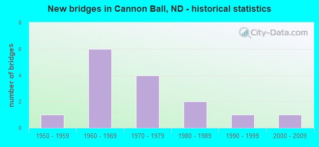
- New bridges - historical statistics
- 11950-1959
- 61960-1969
- 41970-1979
- 21980-1989
- 11990-1999
- 12000-2009

- Bridge Condition - Deck
- 10.0%Excellent
- 10.0%Very good
- 30.0%Good
- 30.0%Satisfactory
- 20.0%Fair

- Bridge Condition - Superstructure
- 8.3%Excellent
- 25.0%Very good
- 25.0%Good
- 25.0%Satisfactory
- 16.7%Fair

- Bridge Condition - Substructure
- 8.3%Excellent
- 41.7%Good
- 33.3%Satisfactory
- 16.7%Fair

- Bridge Condition - Channel
- 6.7%Excellent
- 20.0%Very good
- 33.3%Good
- 6.7%Satisfactory
- 33.3%Fair

- Bridge Condition - Culverts
- 33.3%Very good
- 33.3%Good
- 33.3%Satisfactory
Find on map >> Show street view
Structure Number: 1510519, Location: 12 WEST OF TEMVIK (Lat: 46.370928, Lng: -100.520003), Route carried "on" structure: County highway , Year Built: 1952, Status: Posted for load, Structure Length: 1.95m (6.40ft), Average Daily Traffic: 5 (year 2019), Average Future Daily Traffic: 5 (year 2039), Design Load: H 15, Features Intersected: CREEK, Facility Carried by Structure: 72ND ST SW
Minimum Vertical Clearance: 30+ m (98+ ft), Kilometerpoint: 0.000, Lanes on structure: 2, Owner: County Highway Agency, Approaching Roadway Width: 6.7m (22.0ft), Material/Design: Concrete continuous, Design/Construction: Slab, Number Of Spans In Main Unit: 3, Length of Maximum Span: 7.0m (23.0ft), Curb or Sidewalk Widths: Left: 0.1m (0.3ft), Right: 0.1m (0.3ft), Curb-To-Curb Width: 6.1m (20.0ft), Out-to-Out Width: 6.7m (22.0ft)
Condition: Deck: Good, Superstructure: Good, Substructure: Good, Channel: Good, Operating Rating: 13.7 metric tons, Method Used To Determine Operating Rating: Load Factor (LF), Inventory Rating: 6.4 metric tons, Method Used To Determine Inventory Rating: Load Factor (LF), Structural Evaluation: High priority of replacement, Deck Geometry: Somewhat better than minimum adequacy, Waterway Adequacy: Superior to present desirable criteria, Approach Roadway Alignment: Equal to present minimum criteria, Bridge Posting: Required (Relationship of Operating Rating to Maximum Legal Load: > 39.9% below), Length Of Structure Improvement: 3.87m (12.70ft), Designated Inspection Frequency: Every 24 months, Inspection Date: October 2021, Bridge Improvement Cost: $174,000, Roadway Improvement Cost: $17,000, Total Project Cost: $261,000, Deck Structure Type: Concrete Cast-file-Place, Wearing Surface/Protective System: Wearing Surface: Gravel
Find on map >> Show street view
Structure Number: 301674, Location: 2 N 4 E OF SOLEN (Lat: 46.414000, Lng: -100.709000), Route carried "on" structure: County highway , Year Built: 1970, Status: Posted for load, Structure Length: 0.64m (2.10ft), Average Daily Traffic: 10 (year 2019), Average Future Daily Traffic: 10 (year 2039), Features Intersected: CREEK, Facility Carried by Structure: 69TH ST
Minimum Vertical Clearance: 30+ m (98+ ft), Kilometerpoint: 0.000, Lanes on structure: 2, Owner: County Highway Agency, Approaching Roadway Width: 6.1m (20.0ft), Material/Design: Wood or Timber, Design/Construction: Stringer/Multi-beam, Number Of Spans In Main Unit: 1, Length of Maximum Span: 5.9m (19.4ft), Curb-To-Curb Width: 6.2m (20.3ft), Out-to-Out Width: 6.2m (20.3ft)
Condition: Deck: Fair, Superstructure: Fair, Substructure: Satisfactory, Channel: Fair, Operating Rating: 30.3 metric tons, Method Used To Determine Operating Rating: Allowable Stress (AS), Inventory Rating: 22.1 metric tons, Method Used To Determine Inventory Rating: Allowable Stress (AS), Structural Evaluation: Somewhat better than minimum adequacy, Deck Geometry: Somewhat better than minimum adequacy, Waterway Adequacy: Somewhat better than minimum adequacy, Approach Roadway Alignment: Equal to present minimum criteria, Designated Inspection Frequency: Every 24 months, Inspection Date: July 2021, Deck Structure Type: Wood or Timber
Find on map >> Show street view
Structure Number: 3016835, Location: 4 SOUTH 4 WEST OF FT RICE (Lat: 46.475200, Lng: -100.672742), Route carried "on" structure: County highway , Year Built: 1974, Status: Open, Structure Length: 1.25m (4.10ft), Average Daily Traffic: 30 (year 2019), Average Future Daily Traffic: 30 (year 2039), Features Intersected: N BRANCH CANTEPETA CREEK, Facility Carried by Structure: COUNTY HIGHWAY
Minimum Vertical Clearance: 30+ m (98+ ft), Kilometerpoint: 0.000, Lanes on structure: 2, Owner: County Highway Agency, Approaching Roadway Width: 6.1m (20.0ft), Material/Design: Prestressed concrete, Design/Construction: Box Beam or Girders - Multiple, Number Of Spans In Main Unit: 1, Length of Maximum Span: 11.9m (39.0ft), Curb or Sidewalk Widths: Left: 0.2m (0.7ft), Right: 0.2m (0.7ft), Curb-To-Curb Width: 8.8m (28.9ft), Out-to-Out Width: 9.4m (30.8ft)
Condition: Deck: Very good, Superstructure: Very good, Substructure: Good, Channel: Good, Operating Rating: 46.8 metric tons, Method Used To Determine Operating Rating: Allowable Stress (AS), Inventory Rating: 21.6 metric tons, Method Used To Determine Inventory Rating: Allowable Stress (AS), Structural Evaluation: Equal to present minimum criteria, Deck Geometry: Better than present minimum criteria, Waterway Adequacy: Equal to present desirable criteria, Approach Roadway Alignment: Equal to present desirable criteria, Designated Inspection Frequency: Every 24 months, Inspection Date: May 2020
Find on map >> Show street view
Structure Number: 3016837, Location: 6 SOUTH 5 WEST OF FT RICE (Lat: 46.444486, Lng: -100.682497), Route carried "on" structure: County highway , Year Built: 1972, Status: Posted for load, Structure Length: 1.22m (4.00ft), Average Daily Traffic: 20 (year 2019), Average Future Daily Traffic: 20 (year 2039), Features Intersected: NW BR CANTEPETA CREEK, Facility Carried by Structure: COUNTY HIGHWAY
Minimum Vertical Clearance: 30+ m (98+ ft), Kilometerpoint: 0.000, Lanes on structure: 2, Owner: County Highway Agency, Approaching Roadway Width: 6.1m (20.0ft), Material/Design: Wood or Timber, Design/Construction: Stringer/Multi-beam, Number Of Spans In Main Unit: 1, Length of Maximum Span: 11.6m (38.1ft), Curb or Sidewalk Widths: Left: 0.2m (0.7ft), Right: 0.2m (0.7ft), Curb-To-Curb Width: 7.1m (23.3ft), Out-to-Out Width: 7.4m (24.3ft)
Condition: Deck: Satisfactory, Superstructure: Satisfactory, Substructure: Fair, Channel: Fair, Operating Rating: 12.3 metric tons, Method Used To Determine Operating Rating: Load Factor (LF), Inventory Rating: 7.4 metric tons, Method Used To Determine Inventory Rating: Load Factor (LF), Structural Evaluation: High priority of corrective action, Deck Geometry: Somewhat better than minimum adequacy, Waterway Adequacy: Somewhat better than minimum adequacy, Approach Roadway Alignment: Better than present minimum criteria, Bridge Posting: Required (Relationship of Operating Rating to Maximum Legal Load: > 39.9% below), Length Of Structure Improvement: 1.22m (4.00ft), Designated Inspection Frequency: Every 24 months, Inspection Date: May 2020, Bridge Improvement Cost: $64,000, Roadway Improvement Cost: $6,000, Total Project Cost: $96,000, Deck Structure Type: Wood or Timber, Wearing Surface/Protective System: Wearing Surface: Gravel
Find on map >> Show street view
Structure Number: 3016838, Location: 6 SOUTH 4 WEST OF FT RICE (Lat: 46.444131, Lng: -100.679267), Route carried "on" structure: County highway , Year Built: 1972, Status: Posted for load, Structure Length: 1.22m (4.00ft), Average Daily Traffic: 20 (year 2019), Average Future Daily Traffic: 20 (year 2039), Features Intersected: NW BR CANTEPETA CREEK, Facility Carried by Structure: COUNTY HIGHWAY
Minimum Vertical Clearance: 30+ m (98+ ft), Kilometerpoint: 0.000, Lanes on structure: 2, Owner: County Highway Agency, Approaching Roadway Width: 6.1m (20.0ft), Material/Design: Wood or Timber, Design/Construction: Stringer/Multi-beam, Number Of Spans In Main Unit: 1, Length of Maximum Span: 11.6m (38.1ft), Curb or Sidewalk Widths: Left: 0.2m (0.7ft), Right: 0.2m (0.7ft), Curb-To-Curb Width: 7.1m (23.3ft), Out-to-Out Width: 7.4m (24.3ft)
Condition: Deck: Satisfactory, Superstructure: Satisfactory, Substructure: Satisfactory, Channel: Fair, Operating Rating: 16.6 metric tons, Method Used To Determine Operating Rating: Load Factor (LF), Inventory Rating: 11.4 metric tons, Method Used To Determine Inventory Rating: Load Factor (LF), Structural Evaluation: Meets minimum limits, Deck Geometry: Somewhat better than minimum adequacy, Waterway Adequacy: Somewhat better than minimum adequacy, Approach Roadway Alignment: Better than present minimum criteria, Bridge Posting: Required (Relationship of Operating Rating to Maximum Legal Load: > 39.9% below), Length Of Structure Improvement: 3.29m (10.79ft), Designated Inspection Frequency: Every 24 months, Inspection Date: May 2020, Bridge Improvement Cost: $148,000, Roadway Improvement Cost: $15,000, Total Project Cost: $222,000, Deck Structure Type: Wood or Timber, Wearing Surface/Protective System: Wearing Surface: Gravel
Find on map >> Show street view
Structure Number: 3016938, Location: 6 SOUTH 3 WEST OF FT RICE (Lat: 46.437281, Lng: -100.651578), Route carried "on" structure: County highway , Year Built: 1983, Status: Open, Structure Length: 2.26m (7.41ft), Average Daily Traffic: 35 (year 2019), Average Future Daily Traffic: 35 (year 2039), Design Load: H 20, Features Intersected: CANTEPETA CREEK, Facility Carried by Structure: COUNTY HIGHWAY
Minimum Vertical Clearance: 30+ m (98+ ft), Kilometerpoint: 0.000, Lanes on structure: 2, Owner: County Highway Agency, Approaching Roadway Width: 6.1m (20.0ft), Material/Design: Prestressed concrete, Design/Construction: Box Beam or Girders - Single/Spread, Number Of Spans In Main Unit: 1, Length of Maximum Span: 21.6m (70.9ft), Curb-To-Curb Width: 8.5m (27.9ft), Out-to-Out Width: 9.4m (30.8ft)
Condition: Deck: Satisfactory, Superstructure: Very good, Substructure: Good, Channel: Fair, Operating Rating: 56.8 metric tons, Method Used To Determine Operating Rating: Load Factor (LF), Inventory Rating: 25.1 metric tons, Method Used To Determine Inventory Rating: Load Factor (LF), Structural Evaluation: Equal to present minimum criteria, Deck Geometry: Better than present minimum criteria, Waterway Adequacy: Equal to present desirable criteria, Approach Roadway Alignment: Better than present minimum criteria, Designated Inspection Frequency: Every 24 months, Inspection Date: May 2020, Deck Structure Type: Concrete Cast-file-Place, Wearing Surface/Protective System: Wearing Surface: Monolithic Concrete
Find on map >> Show street view
Structure Number: 4316016, Location: 4 WEST 8 NORTH FT YATES (Lat: 46.193517, Lng: -100.752203), Route carried "on" structure: County highway 4363, Year Built: 1991, Status: Open, Structure Length: 2.93m (9.61ft), Average Daily Traffic: 10 (year 2019), Average Future Daily Traffic: 10 (year 2039), Design Load: HS 25 or greater, Features Intersected: PORCUPINE CREEK, Facility Carried by Structure: IRRSR COUNTY HIWAY
Minimum Vertical Clearance: 30+ m (98+ ft), Kilometerpoint: 0.000, Lanes on structure: 2, Owner: County Highway Agency, Approaching Roadway Width: 7.3m (24.0ft), Skew: 1 degrees, Material/Design: Prestressed concrete continuous, Design/Construction: Box Beam or Girders - Single/Spread, Number Of Spans In Main Unit: 3, Length of Maximum Span: 11.9m (39.0ft), Curb-To-Curb Width: 8.5m (27.9ft), Out-to-Out Width: 9.5m (31.2ft)
Condition: Deck: Excellent, Superstructure: Excellent, Substructure: Excellent, Channel: Good, Operating Rating: 53.9 metric tons, Method Used To Determine Operating Rating: Load Factor (LF), Inventory Rating: 31.0 metric tons, Method Used To Determine Inventory Rating: Load Factor (LF), Structural Evaluation: Better than present minimum criteria, Deck Geometry: Better than present minimum criteria, Waterway Adequacy: Superior to present desirable criteria, Approach Roadway Alignment: Equal to present desirable criteria, Designated Inspection Frequency: Every 24 months, Inspection Date: April 2020, Deck Structure Type: Concrete Cast-file-Place, Wearing Surface/Protective System: Wearing Surface: Monolithic Concrete
Find on map >> Show street view
Structure Number: 4316514, Location: 10 NORTH OF FORT YATES (Lat: 46.218769, Lng: -100.663567), Route carried "on" structure: County highway , Year Built: 2002, Status: Open, Structure Length: 1.16m (3.81ft), Average Daily Traffic: 20 (year 2017), Average Future Daily Traffic: 20 (year 2037), Design Load: HS 25 or greater, Features Intersected: BATTLE CREEK, Facility Carried by Structure: BIASR COUNTY HIWAY
Minimum Vertical Clearance: 30+ m (98+ ft), Kilometerpoint: 0.000, Lanes on structure: 2, Owner: County Highway Agency, Approaching Roadway Width: 6.1m (20.0ft), Skew: 3 degrees, Material/Design: Concrete, Design/Construction: Culvert, Number Of Spans In Main Unit: 3, Length of Maximum Span: 3.7m (12.1ft)
Condition: Channel: Very good, Culverts: Very good, Inventory Rating: 72.8 metric tons, Method Used To Determine Inventory Rating: Load Factor (LF), Structural Evaluation: Equal to present desirable criteria, Waterway Adequacy: Equal to present desirable criteria, Approach Roadway Alignment: Equal to present desirable criteria, Designated Inspection Frequency: Every 48 months, Inspection Date: April 2020
Find on map >> Show street view
Structure Number: 24015004, Location: 5 NORTH OF FORT YATES (Lat: 46.166667, Lng: -100.683333), Route carried "on" structure: State highway 24, Year Built: 1963, Status: Open, Structure Length: 6.10m (20.01ft), Average Daily Traffic: 1,740 (year 2019), Truck Traffic: 5%, Average Future Daily Traffic: 1,852 (year 2039), Design Load: HS 20, Features Intersected: PORCUPINE CREEK
Minimum Vertical Clearance: 30+ m (98+ ft), Kilometerpoint: 24.141, Lanes on structure: 2, Base Highway Network: Yes, Owner: State Highway Agency, Approaching Roadway Width: 9.1m (29.9ft), Material/Design: Prestressed concrete continuous, Design/Construction: Stringer/Multi-beam, Number Of Spans In Main Unit: 3, Length of Maximum Span: 19.8m (65.0ft), Curb-To-Curb Width: 9.2m (30.2ft), Out-to-Out Width: 10.8m (35.4ft)
Condition: Deck: Fair, Superstructure: Good, Substructure: Satisfactory, Channel: Excellent, Inventory Rating: 57.9 metric tons, Method Used To Determine Inventory Rating: Load Factor (LF), Structural Evaluation: Equal to present minimum criteria, Deck Geometry: Somewhat better than minimum adequacy, Waterway Adequacy: Superior to present desirable criteria, Approach Roadway Alignment: Better than present minimum criteria, Designated Inspection Frequency: Every 24 months, Inspection Date: June 2020, Deck Structure Type: Concrete Cast-file-Place, Wearing Surface/Protective System: Wearing Surface: Monolithic Concrete
Find on map >> Show street view
Structure Number: 24018647, Location: 9 NORTH OF FORT YATES (Lat: 46.211500, Lng: -100.648889), Route carried "on" structure: State highway 24, Year Built: 1965, Status: Open, Structure Length: 0.79m (2.59ft), Average Daily Traffic: 1,700 (year 2018), Truck Traffic: 5%, Average Future Daily Traffic: 1,850 (year 2038), Design Load: HS 20, Features Intersected: BATTLE CREEK
Minimum Vertical Clearance: 30+ m (98+ ft), Kilometerpoint: 30.003, Lanes on structure: 2, Base Highway Network: Yes, Owner: State Highway Agency, Approaching Roadway Width: 10.4m (34.1ft), Material/Design: Concrete, Design/Construction: Culvert, Number Of Spans In Main Unit: 3, Length of Maximum Span: 2.4m (7.9ft)
Condition: Channel: Satisfactory, Culverts: Good, Operating Rating: 54.0 metric tons, Method Used To Determine Operating Rating: Load Factor (LF), Inventory Rating: 32.4 metric tons, Method Used To Determine Inventory Rating: Load Factor (LF), Structural Evaluation: Better than present minimum criteria, Waterway Adequacy: Equal to present desirable criteria, Approach Roadway Alignment: Equal to present desirable criteria, Designated Inspection Frequency: Every 48 months, Inspection Date: June 2020
Find on map >> Show street view
Structure Number: 24025856, Location: 4 SOUTH ND 1806 (Lat: 46.313403, Lng: -100.637553), Route carried "on" structure: State highway 24, Year Built: 1965, Status: Open, Structure Length: 1.25m (4.10ft), Average Daily Traffic: 1,830 (year 2019), Truck Traffic: 4%, Average Future Daily Traffic: 2,262 (year 2039), Design Load: HS 20, Features Intersected: BEAVER HOLES CREEK
Minimum Vertical Clearance: 30+ m (98+ ft), Kilometerpoint: 41.602, Lanes on structure: 2, Base Highway Network: Yes, Owner: State Highway Agency, Approaching Roadway Width: 10.4m (34.1ft), Material/Design: Steel, Design/Construction: Culvert, Number Of Spans In Main Unit: 2, Length of Maximum Span: 3.7m (12.1ft)
Condition: Channel: Fair, Culverts: Satisfactory, Operating Rating: 54.0 metric tons, Method Used To Determine Operating Rating: Load Factor (LF), Inventory Rating: 32.4 metric tons, Method Used To Determine Inventory Rating: Load Factor (LF), Structural Evaluation: Equal to present minimum criteria, Waterway Adequacy: Superior to present desirable criteria, Approach Roadway Alignment: Equal to present desirable criteria, Designated Inspection Frequency: Every 24 months, Inspection Date: June 2020
Find on map >> Show street view
Structure Number: 18040272, Location: 2 SOUTH 14 WEST LINTON (Lat: 46.245000, Lng: -100.525000), Route carried "on" structure: State highway 1804, Year Built: 1969, Status: Open, Structure Length: 9.27m (30.41ft), Average Daily Traffic: 230 (year 2019), Truck Traffic: 9%, Average Future Daily Traffic: 222 (year 2039), Design Load: HS 15, Features Intersected: BEAVER BAY
Minimum Vertical Clearance: 30+ m (98+ ft), Kilometerpoint: 39.078, Lanes on structure: 2, Owner: State Highway Agency, Approaching Roadway Width: 11.0m (36.1ft), Material/Design: Steel continuous, Design/Construction: Stringer/Multi-beam, Number Of Spans In Main Unit: 3, Length of Maximum Span: 34.7m (113.8ft), Curb or Sidewalk Widths: Left: 0.3m (1.0ft), Right: 0.3m (1.0ft), Curb-To-Curb Width: 7.3m (24.0ft), Out-to-Out Width: 8.0m (26.2ft)
Condition: Deck: Good, Superstructure: Satisfactory, Substructure: Fair, Channel: Very good, Operating Rating: 54.5 metric tons, Method Used To Determine Operating Rating: Load Factor (LF), Inventory Rating: 32.6 metric tons, Method Used To Determine Inventory Rating: Load Factor (LF), Structural Evaluation: Somewhat better than minimum adequacy, Deck Geometry: Somewhat better than minimum adequacy, Waterway Adequacy: Superior to present desirable criteria, Approach Roadway Alignment: Equal to present desirable criteria, Length Of Structure Improvement: 9.27m (30.41ft), Designated Inspection Frequency: Every 24 months, Inspection Date: June 2021, Bridge Improvement Cost: $429,000, Roadway Improvement Cost: $43,000, Total Project Cost: $644,000, Deck Structure Type: Concrete Cast-file-Place, Wearing Surface/Protective System: Wearing Surface: Low Slump Concrete
Find on map >> Show street view
Structure Number: 1804036432, Location: 11 WEST OF TEMVIK (Lat: 46.368333, Lng: -100.503333), Route carried "on" structure: State highway 1804, Year Built: 1985, Status: Open, Structure Length: 3.72m (12.20ft), Average Daily Traffic: 210 (year 2019), Truck Traffic: 14%, Average Future Daily Traffic: 215 (year 2039), Design Load: H 20, Features Intersected: HORSE HEAD CREEK
Minimum Vertical Clearance: 30+ m (98+ ft), Kilometerpoint: 55.361, Lanes on structure: 2, Owner: State Highway Agency, Approaching Roadway Width: 9.8m (32.2ft), Material/Design: Prestressed concrete continuous, Design/Construction: Box Beam or Girders - Single/Spread, Number Of Spans In Main Unit: 3, Length of Maximum Span: 18.0m (59.1ft), Curb-To-Curb Width: 9.8m (32.2ft), Out-to-Out Width: 10.6m (34.8ft)
Condition: Deck: Good, Superstructure: Very good, Substructure: Good, Channel: Very good, Operating Rating: 63.4 metric tons, Method Used To Determine Operating Rating: Load Factor (LF), Inventory Rating: 37.9 metric tons, Method Used To Determine Inventory Rating: Load Factor (LF), Structural Evaluation: Better than present minimum criteria, Deck Geometry: Better than present minimum criteria, Waterway Adequacy: Superior to present desirable criteria, Approach Roadway Alignment: Equal to present desirable criteria, Designated Inspection Frequency: Every 24 months, Inspection Date: June 2021, Deck Structure Type: Concrete Cast-file-Place, Wearing Surface/Protective System: Wearing Surface: Monolithic Concrete
Find on map >> Show street view
Structure Number: 180603428, Location: 3 NORTH OF ND 24 (Lat: 46.415289, Lng: -100.635242), Route carried "on" structure: State highway 1806, Year Built: 1962, Status: Open, Structure Length: 11.98m (39.30ft), Average Daily Traffic: 1,450 (year 2019), Truck Traffic: 8%, Average Future Daily Traffic: 1,551 (year 2039), Design Load: H 20, Features Intersected: CANNONBALL RIVER
Minimum Vertical Clearance: 30+ m (98+ ft), Kilometerpoint: 55.157, Lanes on structure: 2, Base Highway Network: Yes, Owner: State Highway Agency, Approaching Roadway Width: 11.0m (36.1ft), Material/Design: Prestressed concrete, Design/Construction: Box Beam or Girders - Multiple, Number Of Spans In Main Unit: 6, Length of Maximum Span: 19.2m (63.0ft), Curb or Sidewalk Widths: Left: 0.1m (0.3ft), Right: 0.1m (0.3ft), Curb-To-Curb Width: 8.6m (28.2ft), Out-to-Out Width: 9.2m (30.2ft)
Condition: Superstructure: Fair, Substructure: Satisfactory, Channel: Good, Operating Rating: 46.5 metric tons, Method Used To Determine Operating Rating: Load Factor (LF), Inventory Rating: 27.9 metric tons, Method Used To Determine Inventory Rating: Load Factor (LF), Structural Evaluation: Somewhat better than minimum adequacy, Deck Geometry: Somewhat better than minimum adequacy, Waterway Adequacy: Equal to present desirable criteria, Approach Roadway Alignment: Equal to present desirable criteria, Length Of Structure Improvement: 11.98m (39.30ft), Designated Inspection Frequency: Every 24 months, Inspection Date: June 2021, Bridge Improvement Cost: $594,000, Roadway Improvement Cost: $59,000, Total Project Cost: $891,000, Wearing Surface/Protective System: Wearing Surface: Bituminous
Find on map >> Show street view
Structure Number: 180603507, Location: 4 NORTH OF ND 24 (Lat: 46.426144, Lng: -100.635353), Route carried "on" structure: State highway 1806, Year Built: 1962, Status: Open, Structure Length: 4.94m (16.21ft), Average Daily Traffic: 1,450 (year 2019), Truck Traffic: 8%, Average Future Daily Traffic: 1,540 (year 2039), Design Load: H 20, Features Intersected: CANTA PETA CREEK
Minimum Vertical Clearance: 30+ m (98+ ft), Kilometerpoint: 56.428, Lanes on structure: 2, Base Highway Network: Yes, Owner: State Highway Agency, Approaching Roadway Width: 11.3m (37.1ft), Skew: 2 degrees, Material/Design: Prestressed concrete, Design/Construction: Box Beam or Girders - Multiple, Number Of Spans In Main Unit: 3, Length of Maximum Span: 17.1m (56.1ft), Curb or Sidewalk Widths: Left: 0.1m (0.3ft), Right: 0.1m (0.3ft), Curb-To-Curb Width: 8.6m (28.2ft), Out-to-Out Width: 9.2m (30.2ft)
Condition: Superstructure: Good, Substructure: Good, Channel: Good, Operating Rating: 55.2 metric tons, Method Used To Determine Operating Rating: Load Factor (LF), Inventory Rating: 33.1 metric tons, Method Used To Determine Inventory Rating: Load Factor (LF), Structural Evaluation: Better than present minimum criteria, Deck Geometry: Somewhat better than minimum adequacy, Waterway Adequacy: Equal to present desirable criteria, Approach Roadway Alignment: Equal to present desirable criteria, Length Of Structure Improvement: 4.94m (16.21ft), Designated Inspection Frequency: Every 24 months, Inspection Date: June 2020, Bridge Improvement Cost: $245,000, Roadway Improvement Cost: $25,000, Total Project Cost: $368,000