Bridge Statistics for Canonsburg, Pennsylvania (PA)
Condition, Traffic, Stress, Structural Evaluation, Project Costs
- National Bridge Inventory (NBI) Statistics
- 42Number of bridges
- 453ft / 138mTotal length
- $11,309,000Total costs
- 481,601Total average daily traffic
- 45,260Total average daily truck traffic
- National Bridge Inventory (NBI) Registered Bridges for Canonsburg
- No street view available for this location
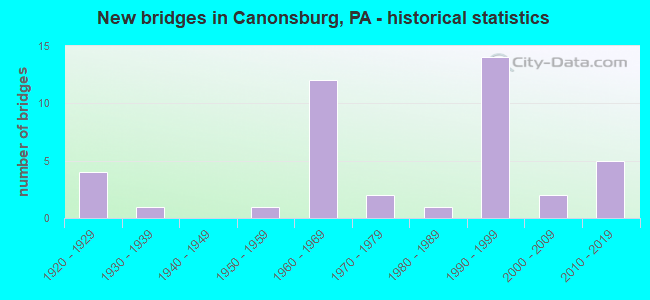
- New bridges - historical statistics
- 41920-1929
- 11930-1939
- 11950-1959
- 121960-1969
- 21970-1979
- 11980-1989
- 141990-1999
- 22000-2009
- 52010-2019
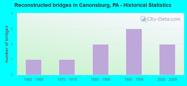
- Reconstructed bridges - Historical Statistics
- 11960-1969
- 11970-1979
- 21980-1989
- 31990-1999
- 22000-2009
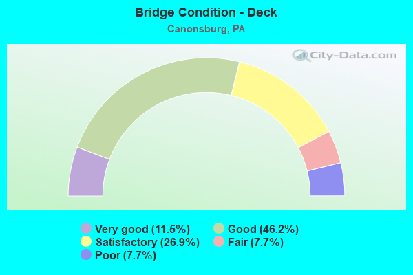
- Bridge Condition - Deck
- 11.5%Very good
- 46.2%Good
- 26.9%Satisfactory
- 7.7%Fair
- 7.7%Poor
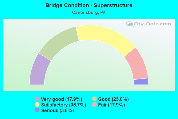
- Bridge Condition - Superstructure
- 17.9%Very good
- 25.0%Good
- 35.7%Satisfactory
- 17.9%Fair
- 3.6%Serious
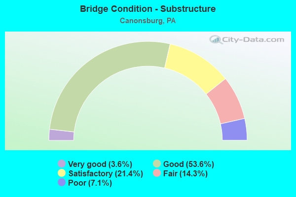
- Bridge Condition - Substructure
- 3.6%Very good
- 53.6%Good
- 21.4%Satisfactory
- 14.3%Fair
- 7.1%Poor
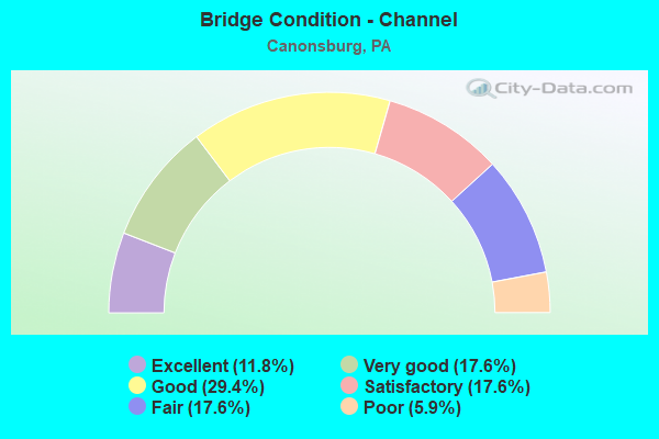
- Bridge Condition - Channel
- 11.8%Excellent
- 17.6%Very good
- 29.4%Good
- 17.6%Satisfactory
- 17.6%Fair
- 5.9%Poor
Find on map >> Show street view
Structure Number: 7463, Location: BEDMINSTER TWP. 16C02 (Lat: 40.433692, Lng: -75.188306), Route carried "on" structure: State highway , Year Built: 1933, Status: Posted for load, Structure Length: 1.31m (4.30ft), Average Daily Traffic: 701 (year 2022), Truck Traffic: 9%, Average Future Daily Traffic: 843 (year 2032), Design Load: H 20, Features Intersected: DEER RUN, Facility Carried by Structure: KELLERS CHURCH RD.
Minimum Vertical Clearance: 30+ m (98+ ft), Kilometerpoint: 6.994, Lanes on structure: 2, Owner: State Highway Agency, Approaching Roadway Width: 7.3m (24.0ft), Skew: 4 degrees, Material/Design: Concrete, Design/Construction: Tee Beam, Number Of Spans In Main Unit: 1, Length of Maximum Span: 12.8m (42.0ft), Curb-To-Curb Width: 6.7m (22.0ft), Out-to-Out Width: 7.3m (24.0ft)
Condition: Deck: Poor, Superstructure: Fair, Substructure: Poor, Channel: Poor, Operating Rating: 44.5 metric tons, Method Used To Determine Operating Rating: Load Factor (LF), Inventory Rating: 26.3 metric tons, Method Used To Determine Inventory Rating: Load Factor (LF), Structural Evaluation: Meets minimum limits, Deck Geometry: Meets minimum limits, Waterway Adequacy: Better than present minimum criteria, Approach Roadway Alignment: Equal to present minimum criteria, Length Of Structure Improvement: 1.60m (5.25ft), Designated Inspection Frequency: Every 24 months, Other Special Inspection Frequency: Every 12 months, Inspection Date: September 2020, Other Special Inspection Date: October 2021, Bridge Improvement Cost: $15,000, Roadway Improvement Cost: $99,000, Total Project Cost: $205,000, Deck Structure Type: Concrete Cast-file-Place, Wearing Surface/Protective System: Wearing Surface: Bituminous
Find on map >> Show street view
Structure Number: 16642, Location: SPRINGHILL/NICHOLSON TWP. (Lat: 39.785664, Lng: -79.915806), Route carried "on" structure: State highway 166, Year Built: 1994, Status: Open, Structure Length: 4.79m (15.72ft), Average Daily Traffic: 1,261 (year 2020), Truck Traffic: 7%, Average Future Daily Traffic: 2,122 (year 2032), Design Load: HS 25 or greater, Features Intersected: GEORGE CREEK
Minimum Vertical Clearance: 30+ m (98+ ft), Kilometerpoint: 6.016, Lanes on structure: 2, Base Highway Network: Yes, Owner: State Highway Agency, Approaching Roadway Width: 12.2m (40.0ft), Material/Design: Steel, Design/Construction: Stringer/Multi-beam, Number Of Spans In Main Unit: 1, Length of Maximum Span: 47.2m (154.9ft), Curb or Sidewalk Widths: Left: 0.2m (0.7ft), Right: 0.2m (0.7ft), Curb-To-Curb Width: 12.2m (40.0ft), Out-to-Out Width: 13.3m (43.6ft)
Condition: Deck: Good, Superstructure: Good, Substructure: Good, Channel: Very good, Inventory Rating: 65.3 metric tons, Method Used To Determine Inventory Rating: Load Factor (LF), Structural Evaluation: Better than present minimum criteria, Deck Geometry: Better than present minimum criteria, Waterway Adequacy: High priority of corrective action, Approach Roadway Alignment: Equal to present desirable criteria, Length Of Structure Improvement: 3.70m (12.14ft), Designated Inspection Frequency: Every 48 months, Inspection Date: November 2020, Deck Structure Type: Concrete Cast-file-Place, Wearing Surface/Protective System: Wearing Surface: Monolithic Concrete, Deck Protection: Epoxy Coated Reinforcing
Find on map >> Show street view
Structure Number: 31046, Location: 1 MI S OF SELINSGROVE (Lat: 40.786378, Lng: -76.863678), Route carried "on" structure: US 11, Year Built: 1976, Status: Open, Structure Length: 5.82m (19.09ft), Average Daily Traffic: 9,295 (year 2021), Truck Traffic: 25%, Average Future Daily Traffic: 8,464 (year 2032), Design Load: HS 20, Features Intersected: OVER SR 35
Minimum Vertical Clearance: 30+ m (98+ ft), Kilometerpoint: 18.831, Lanes on structure: 2, Lanes under structure: 4, Base Highway Network: Yes, Owner: State Highway Agency, Approaching Roadway Width: 11.6m (38.1ft), Skew: 10 degrees, Material/Design: Prestressed concrete, Design/Construction: Stringer/Multi-beam, Number Of Spans In Main Unit: 3, Length of Maximum Span: 32.0m (105.0ft), Curb or Sidewalk Widths: Left: 0.2m (0.7ft), Right: 0.2m (0.7ft), Curb-To-Curb Width: 11.9m (39.0ft), Out-to-Out Width: 13.2m (43.3ft)
Condition: Deck: Good, Superstructure: Good, Substructure: Good, Operating Rating: 59.0 metric tons, Method Used To Determine Operating Rating: Load Factor (LF), Inventory Rating: 33.6 metric tons, Method Used To Determine Inventory Rating: Load Factor (LF), Structural Evaluation: Better than present minimum criteria, Deck Geometry: Better than present minimum criteria, Underclear: Better than present minimum criteria, Approach Roadway Alignment: Equal to present desirable criteria, Length Of Structure Improvement: 6.80m (22.31ft), Designated Inspection Frequency: Every 24 months, Inspection Date: April 2021, Deck Structure Type: Concrete Cast-file-Place, Wearing Surface/Protective System: Wearing Surface: Monolithic Concrete
Find on map >> Show street view
Structure Number: 31403, Location: 3.0 MILE SOUTH OF TR 30 (Lat: 40.098731, Lng: -79.031233), Route carried "on" structure: US 219, Year Built: 2001, Status: Open, Structure Length: 1.74m (5.71ft), Average Daily Traffic: 5,156 (year 2020), Truck Traffic: 9%, Average Future Daily Traffic: 5,729 (year 2032), Design Load: HL 93, Features Intersected: T893 MILOW-KIMMER ROAD
Minimum Vertical Clearance: 30+ m (98+ ft), Kilometerpoint: 47.530, Lanes on structure: 2, Lanes under structure: 2, Base Highway Network: Yes, Owner: State Highway Agency, Approaching Roadway Width: 12.2m (40.0ft), Skew: 11 degrees, Material/Design: Prestressed concrete, Design/Construction: Box Beam or Girders - Multiple, Number Of Spans In Main Unit: 1, Length of Maximum Span: 16.8m (55.1ft), Curb or Sidewalk Widths: Left: 0.2m (0.7ft), Right: 0.2m (0.7ft), Curb-To-Curb Width: 12.2m (40.0ft), Out-to-Out Width: 13.1m (43.0ft)
Condition: Deck: Good, Superstructure: Very good, Substructure: Good, Operating Rating: 61.7 metric tons, Method Used To Determine Operating Rating: Load and Resistance Factor (LRFR), Inventory Rating: 39.0 metric tons, Method Used To Determine Inventory Rating: Load and Resistance Factor (LRFR), Structural Evaluation: Better than present minimum criteria, Deck Geometry: Better than present minimum criteria, Underclear: Equal to present minimum criteria, Approach Roadway Alignment: Equal to present desirable criteria, Length Of Structure Improvement: 3.80m (12.47ft), Designated Inspection Frequency: Every 48 months, Inspection Date: August 2019, Bridge Improvement Cost: $154,000, Roadway Improvement Cost: $453,000, Total Project Cost: $1,917,000, Deck Structure Type: Concrete Cast-file-Place, Wearing Surface/Protective System: Wearing Surface: Monolithic Concrete, Deck Protection: Epoxy Coated Reinforcing
Find on map >> Show street view
Structure Number: 34575, Location: CANNONSBURG BOROUGH (Lat: 40.253558, Lng: -80.184483), Route carried "on" structure: Interstate 79, Year Built: 1966, Year Reconstructed: 1994, Status: Open, Structure Length: 7.44m (24.41ft), Average Daily Traffic: 18,647 (year 2021), Truck Traffic: 12%, Average Future Daily Traffic: 10,296 (year 2032), Design Load: H 20, Features Intersected: SR 0980
Minimum Vertical Clearance: 30+ m (98+ ft), Kilometerpoint: 28.112, Lanes on structure: 2, Lanes under structure: 2, Base Highway Network: Yes, Owner: State Highway Agency, Approaching Roadway Width: 9.8m (32.2ft), Skew: 10 degrees, Material/Design: Prestressed concrete, Design/Construction: Box Beam or Girders - Single/Spread, Number Of Spans In Main Unit: 3, Length of Maximum Span: 24.1m (79.1ft), Curb or Sidewalk Widths: Left: 0.2m (0.7ft), Right: 0.2m (0.7ft), Curb-To-Curb Width: 10.4m (34.1ft), Out-to-Out Width: 11.4m (37.4ft)
Condition: Deck: Satisfactory, Superstructure: Satisfactory, Substructure: Good, Operating Rating: 87.1 metric tons, Method Used To Determine Operating Rating: Load Factor (LF), Inventory Rating: 47.2 metric tons, Method Used To Determine Inventory Rating: Load Factor (LF), Structural Evaluation: Equal to present minimum criteria, Deck Geometry: Meets minimum limits, Underclear: Superior to present desirable criteria, Approach Roadway Alignment: Equal to present desirable criteria, Length Of Structure Improvement: 8.40m (27.56ft), Designated Inspection Frequency: Every 24 months, Inspection Date: September 2021, Bridge Improvement Cost: $141,000, Roadway Improvement Cost: $414,000, Total Project Cost: $1,899,000, Deck Structure Type: Concrete Cast-file-Place, Wearing Surface/Protective System: Wearing Surface: Monolithic Concrete, Deck Protection: Epoxy Coated Reinforcing
Find on map >> Show street view
Structure Number: 34576, Location: CANNONSBURG BOROUGH (Lat: 40.253703, Lng: -80.184583), Route carried "on" structure: Interstate 79, Year Built: 1966, Year Reconstructed: 1994, Status: Open, Structure Length: 7.44m (24.41ft), Average Daily Traffic: 32,467 (year 2021), Truck Traffic: 10%, Average Future Daily Traffic: 9,856 (year 2032), Design Load: H 20, Features Intersected: SR 0980
Minimum Vertical Clearance: 30+ m (98+ ft), Kilometerpoint: 28.923, Lanes on structure: 2, Lanes under structure: 2, Base Highway Network: Yes, Owner: State Highway Agency, Approaching Roadway Width: 9.8m (32.2ft), Skew: 10 degrees, Material/Design: Prestressed concrete, Design/Construction: Box Beam or Girders - Single/Spread, Number Of Spans In Main Unit: 3, Length of Maximum Span: 24.1m (79.1ft), Curb or Sidewalk Widths: Left: 0.2m (0.7ft), Right: 0.2m (0.7ft), Curb-To-Curb Width: 10.4m (34.1ft), Out-to-Out Width: 11.4m (37.4ft)
Condition: Deck: Satisfactory, Superstructure: Fair, Substructure: Good, Operating Rating: 77.1 metric tons, Method Used To Determine Operating Rating: Load Factor (LF), Inventory Rating: 23.6 metric tons, Method Used To Determine Inventory Rating: Load Factor (LF), Structural Evaluation: Somewhat better than minimum adequacy, Deck Geometry: Meets minimum limits, Underclear: Superior to present desirable criteria, Approach Roadway Alignment: Equal to present desirable criteria, Length Of Structure Improvement: 7.50m (24.61ft), Designated Inspection Frequency: Every 24 months, Inspection Date: September 2021, Bridge Improvement Cost: $74,000, Roadway Improvement Cost: $217,000, Total Project Cost: $996,000, Deck Structure Type: Concrete Cast-file-Place, Wearing Surface/Protective System: Wearing Surface: Monolithic Concrete, Deck Protection: Epoxy Coated Reinforcing
Find on map >> Show street view
Structure Number: 34578, Location: NORTH STRABANE TOWNSHIP (Lat: 40.259194, Lng: -80.175044), Route carried "on" structure: Interstate 79, Year Built: 1997, Status: Open, Structure Length: 4.94m (16.21ft), Average Daily Traffic: 26,654 (year 2022), Truck Traffic: 12%, Average Future Daily Traffic: 9,856 (year 2032), Design Load: HS 20+Mod, Features Intersected: SR 1025
Minimum Vertical Clearance: 30+ m (98+ ft), Kilometerpoint: 29.725, Lanes on structure: 2, Lanes under structure: 2, Base Highway Network: Yes, Owner: State Highway Agency, Approaching Roadway Width: 12.8m (42.0ft), Skew: 13 degrees, Material/Design: Prestressed concrete continuous, Design/Construction: Box Beam or Girders - Single/Spread, Number Of Spans In Main Unit: 3, Length of Maximum Span: 20.1m (65.9ft), Curb or Sidewalk Widths: Left: 0.2m (0.7ft), Right: 0.2m (0.7ft), Curb-To-Curb Width: 12.8m (42.0ft), Out-to-Out Width: 13.9m (45.6ft)
Condition: Deck: Satisfactory, Superstructure: Satisfactory, Substructure: Satisfactory, Operating Rating: 65.3 metric tons, Method Used To Determine Operating Rating: Load Factor (LF), Inventory Rating: 28.1 metric tons, Method Used To Determine Inventory Rating: Load Factor (LF), Structural Evaluation: Equal to present minimum criteria, Deck Geometry: Equal to present desirable criteria, Underclear: Superior to present desirable criteria, Approach Roadway Alignment: Equal to present desirable criteria, Length Of Structure Improvement: 5.90m (19.36ft), Designated Inspection Frequency: Every 24 months, Inspection Date: September 2021, Bridge Improvement Cost: $137,000, Roadway Improvement Cost: $402,000, Total Project Cost: $1,845,000, Deck Structure Type: Concrete Cast-file-Place, Wearing Surface/Protective System: Wearing Surface: Monolithic Concrete, Deck Protection: Epoxy Coated Reinforcing
Find on map >> Show street view
Structure Number: 34582, Location: N. STRABANE & CECIL TWPS. (Lat: 40.279831, Lng: -80.160925), Route carried "on" structure: Interstate 79, Year Built: 1964, Year Reconstructed: 1997, Status: Open, Structure Length: 10.97m (35.99ft), Average Daily Traffic: 15,105 (year 2021), Truck Traffic: 6%, Average Future Daily Traffic: 11,015 (year 2032), Design Load: HS 25 or greater, Features Intersected: CHARTIERS CREEK
Minimum Vertical Clearance: 30+ m (98+ ft), Kilometerpoint: 32.903, Lanes on structure: 2, Base Highway Network: Yes, Owner: State Highway Agency, Approaching Roadway Width: 9.8m (32.2ft), Skew: 10 degrees, Material/Design: Prestressed concrete, Design/Construction: Stringer/Multi-beam, Number Of Spans In Main Unit: 3, Length of Maximum Span: 42.1m (138.1ft), Curb or Sidewalk Widths: Left: 0.2m (0.7ft), Right: 0.2m (0.7ft), Curb-To-Curb Width: 11.6m (38.1ft), Out-to-Out Width: 12.6m (41.3ft)
Condition: Deck: Satisfactory, Superstructure: Satisfactory, Substructure: Good, Channel: Excellent, Operating Rating: 89.8 metric tons, Method Used To Determine Operating Rating: Load Factor (LF), Inventory Rating: 51.7 metric tons, Method Used To Determine Inventory Rating: Load Factor (LF), Structural Evaluation: Equal to present minimum criteria, Deck Geometry: Equal to present minimum criteria, Waterway Adequacy: Superior to present desirable criteria, Approach Roadway Alignment: Equal to present desirable criteria, Length Of Structure Improvement: 11.00m (36.09ft), Designated Inspection Frequency: Every 24 months, Inspection Date: September 2021, Bridge Improvement Cost: $83,000, Roadway Improvement Cost: $244,000, Total Project Cost: $1,119,000, Deck Structure Type: Concrete Cast-file-Place, Wearing Surface/Protective System: Wearing Surface: Monolithic Concrete, Deck Protection: Epoxy Coated Reinforcing
Find on map >> Show street view
Structure Number: 348, Location: NORTH STRABANE TOWNSHIP (Lat: 40.262050, Lng: -80.176261), Route carried "on" structure: State highway , Year Built: 1974, Year Reconstructed: 2007, Status: Open, Structure Length: 3.17m (10.40ft), Average Daily Traffic: 23,917 (year 2021), Truck Traffic: 4%, Average Future Daily Traffic: 29,370 (year 2032), Design Load: HS 20, Features Intersected: CHARTIERS CREEK, Facility Carried by Structure: SR 1009
Minimum Vertical Clearance: 30+ m (98+ ft), Kilometerpoint: 11.573, Lanes on structure: 4, Owner: State Highway Agency, Approaching Roadway Width: 17.1m (56.1ft), Skew: 22 degrees, Material/Design: Steel, Design/Construction: Stringer/Multi-beam, Number Of Spans In Main Unit: 1, Length of Maximum Span: 31.4m (103.0ft), Curb or Sidewalk Widths: Left: 1.5m (4.9ft), Right: 1.5m (4.9ft), Curb-To-Curb Width: 17.1m (56.1ft), Out-to-Out Width: 20.9m (68.6ft)
Condition: Deck: Good, Superstructure: Satisfactory, Substructure: Fair, Channel: Good, Operating Rating: 88.9 metric tons, Method Used To Determine Operating Rating: Load Factor (LF), Inventory Rating: 53.5 metric tons, Method Used To Determine Inventory Rating: Load Factor (LF), Structural Evaluation: Somewhat better than minimum adequacy, Deck Geometry: Somewhat better than minimum adequacy, Waterway Adequacy: Superior to present desirable criteria, Approach Roadway Alignment: Equal to present desirable criteria, Length Of Structure Improvement: 4.00m (13.12ft), Designated Inspection Frequency: Every 24 months, Inspection Date: March 2020, Bridge Improvement Cost: $76,000, Roadway Improvement Cost: $224,000, Total Project Cost: $1,027,000, Deck Structure Type: Concrete Cast-file-Place, Wearing Surface/Protective System: Wearing Surface: Monolithic Concrete, Deck Protection: Epoxy Coated Reinforcing
Find on map >> Show street view
Structure Number: 34801, Location: N. STRABANE & CECIL TWPS. (Lat: 40.279019, Lng: -80.156078), Route carried "on" structure: State highway , Year Built: 1924, Year Reconstructed: 1983, Status: Open, Structure Length: 2.80m (9.19ft), Average Daily Traffic: 5,188 (year 2021), Truck Traffic: 6%, Average Future Daily Traffic: 7,102 (year 2032), Design Load: H 15, Features Intersected: CHARTIERS CREEK, Facility Carried by Structure: SR 1009
Minimum Vertical Clearance: 30+ m (98+ ft), Kilometerpoint: 13.860, Lanes on structure: 2, Owner: State Highway Agency, Approaching Roadway Width: 7.6m (24.9ft), Material/Design: Concrete, Design/Construction: Arch - Deck, Number Of Spans In Main Unit: 1, Length of Maximum Span: 27.4m (89.9ft), Curb or Sidewalk Widths: Left: 0.2m (0.7ft), Right: 0.2m (0.7ft), Curb-To-Curb Width: 7.5m (24.6ft), Out-to-Out Width: 8.8m (28.9ft)
Condition: Superstructure: Fair, Substructure: Satisfactory, Channel: Satisfactory, Operating Rating: 59.9 metric tons, Method Used To Determine Operating Rating: Field evaluation and documented engineering judgment, Inventory Rating: 36.3 metric tons, Method Used To Determine Inventory Rating: Field evaluation and documented engineering judgment, Structural Evaluation: Somewhat better than minimum adequacy, Deck Geometry: High priority of replacement, Waterway Adequacy: Superior to present desirable criteria, Approach Roadway Alignment: Equal to present desirable criteria, Length Of Structure Improvement: 5.50m (18.04ft), Designated Inspection Frequency: Every 24 months, Inspection Date: March 2020, Deck Structure Type: Other
Find on map >> Show street view
Structure Number: 34831, Location: NORTH STRABANE TOWNSHIP (Lat: 40.264289, Lng: -80.167392), Route carried "on" structure: State highway , Year Built: 1966, Year Reconstructed: 1997, Status: Open, Structure Length: 5.43m (17.81ft), Average Daily Traffic: 14,411 (year 2022), Truck Traffic: 5%, Average Future Daily Traffic: 12,086 (year 2032), Design Load: HS 20+Mod, Features Intersected: SR 0079, Facility Carried by Structure: SR 1023
Minimum Vertical Clearance: 30+ m (98+ ft), Kilometerpoint: 6.539, Lanes on structure: 3, Lanes under structure: 8, Owner: State Highway Agency, Approaching Roadway Width: 12.8m (42.0ft), Skew: 4 degrees, Material/Design: Prestressed concrete continuous, Design/Construction: Box Beam or Girders - Single/Spread, Number Of Spans In Main Unit: 2, Length of Maximum Span: 26.8m (87.9ft), Curb or Sidewalk Widths: Left: 0.2m (0.7ft), Right: 0.2m (0.7ft), Curb-To-Curb Width: 12.8m (42.0ft), Out-to-Out Width: 13.9m (45.6ft)
Condition: Deck: Good, Superstructure: Satisfactory, Substructure: Good, Inventory Rating: 33.6 metric tons, Method Used To Determine Inventory Rating: Load Factor (LF), Structural Evaluation: Equal to present minimum criteria, Deck Geometry: Meets minimum limits, Underclear: Equal to present minimum criteria, Approach Roadway Alignment: Equal to present desirable criteria, Length Of Structure Improvement: 6.50m (21.33ft), Designated Inspection Frequency: Every 24 months, Inspection Date: March 2020, Bridge Improvement Cost: $132,000, Roadway Improvement Cost: $388,000, Total Project Cost: $1,779,000, Deck Structure Type: Concrete Cast-file-Place, Wearing Surface/Protective System: Wearing Surface: Monolithic Concrete, Deck Protection: Epoxy Coated Reinforcing
Find on map >> Show street view
Structure Number: 34832, Location: NORTH STRABANE TOWNSHIP (Lat: 40.249197, Lng: -80.193406), Route carried "on" structure: State highway , Year Built: 1965, Year Reconstructed: 2009, Status: Open, Structure Length: 12.86m (42.19ft), Average Daily Traffic: 2,551 (year 2020), Truck Traffic: 6%, Average Future Daily Traffic: 3,029 (year 2032), Design Load: HL 93, Features Intersected: SR 0079, Facility Carried by Structure: SR 1035
Minimum Vertical Clearance: 30+ m (98+ ft), Kilometerpoint: 0.618, Lanes on structure: 2, Lanes under structure: 4, Owner: State Highway Agency, Approaching Roadway Width: 7.3m (24.0ft), Skew: 4 degrees, Material/Design: Steel continuous, Design/Construction: Frame, Number Of Spans In Main Unit: 3, Length of Maximum Span: 48.8m (160.1ft), Curb or Sidewalk Widths: Left: 1.5m (4.9ft), Right: 0.1m (0.3ft), Curb-To-Curb Width: 8.5m (27.9ft), Out-to-Out Width: 10.9m (35.8ft)
Condition: Deck: Good, Superstructure: Good, Substructure: Good, Operating Rating: 48.9 metric tons, Method Used To Determine Operating Rating: Assigned ratings based on Load and Resistance Factor Design (LRFD) reported by rating factor (RF) using HL93 loadings, Inventory Rating: 34.0 metric tons, Method Used To Determine Inventory Rating: Assigned ratings based on Load and Resistance Factor Design (LRFD) reported by rating factor (RF) using HL93 loadings, Structural Evaluation: Better than present minimum criteria, Deck Geometry: Meets minimum limits, Underclear: Superior to present desirable criteria, Approach Roadway Alignment: Equal to present desirable criteria, Length Of Structure Improvement: 12.80m (41.99ft), Designated Inspection Frequency: Every 24 months, Critical Feature Inspection Frequency: Every 24 months, Inspection Date: March 2020, Critical Feature Inspection Date: March 2020, Bridge Improvement Cost: $36,000, Roadway Improvement Cost: $200,000, Total Project Cost: $487,000, Deck Structure Type: Concrete Cast-file-Place, Wearing Surface/Protective System: Wearing Surface: Monolithic Concrete, Deck Protection: Epoxy Coated Reinforcing
Find on map >> Show street view
Structure Number: 34833, Location: CANONSBURG BOROUGH (Lat: 40.256683, Lng: -80.197100), Route carried "on" structure: State highway , Year Built: 1986, Status: Open, Structure Length: 2.50m (8.20ft), Average Daily Traffic: 2,193 (year 2022), Truck Traffic: 1%, Average Future Daily Traffic: 3,796 (year 2032), Design Load: HS 25 or greater, Features Intersected: CHARTIERS CREEK, Facility Carried by Structure: SR 1037
Minimum Vertical Clearance: 30+ m (98+ ft), Kilometerpoint: 0.806, Lanes on structure: 2, Owner: State Highway Agency, Approaching Roadway Width: 7.3m (24.0ft), Material/Design: Prestressed concrete, Design/Construction: Box Beam or Girders - Multiple, Number Of Spans In Main Unit: 1, Length of Maximum Span: 24.4m (80.1ft), Curb or Sidewalk Widths: Left: 0.2m (0.7ft), Right: 1.6m (5.2ft), Curb-To-Curb Width: 8.8m (28.9ft), Out-to-Out Width: 11.1m (36.4ft)
Condition: Deck: Good, Superstructure: Good, Substructure: Good, Channel: Good, Operating Rating: 89.8 metric tons, Method Used To Determine Operating Rating: Load Factor (LF), Inventory Rating: 52.6 metric tons, Method Used To Determine Inventory Rating: Load Factor (LF), Structural Evaluation: Better than present minimum criteria, Deck Geometry: Meets minimum limits, Waterway Adequacy: Superior to present desirable criteria, Approach Roadway Alignment: Better than present minimum criteria, Length Of Structure Improvement: 3.20m (10.50ft), Designated Inspection Frequency: Every 24 months, Inspection Date: March 2020, Deck Structure Type: Concrete Cast-file-Place, Wearing Surface/Protective System: Wearing Surface: Monolithic Concrete, Deck Protection: Epoxy Coated Reinforcing
Find on map >> Show street view
Structure Number: 35262, Location: 300' SOUTH OF SR 980 (Lat: 40.273825, Lng: -80.191753), Route carried "on" structure: City street T672, Year Built: 1965, Status: Posted for load, Structure Length: 1.01m (3.31ft), Average Daily Traffic: 300 (year 1993), Truck Traffic: 1%, Average Future Daily Traffic: 300 (year 2020), Design Load: HS 15, Features Intersected: CHARTIERS CREEK TRIB, Facility Carried by Structure: VALLEY VIEW ROAD
Minimum Vertical Clearance: 30+ m (98+ ft), Kilometerpoint: 0.000, Lanes on structure: 2, Base Highway Network: Yes, Owner: County Highway Agency, Approaching Roadway Width: 5.2m (17.1ft), Skew: 2 degrees, Material/Design: Steel, Design/Construction: Stringer/Multi-beam, Number Of Spans In Main Unit: 1, Length of Maximum Span: 9.8m (32.2ft), Curb-To-Curb Width: 6.2m (20.3ft), Out-to-Out Width: 7.1m (23.3ft)
Condition: Deck: Poor, Superstructure: Serious, Substructure: Poor, Channel: Satisfactory, Operating Rating: 5.4 metric tons, Method Used To Determine Operating Rating: Load Factor (LF), Inventory Rating: 3.6 metric tons, Method Used To Determine Inventory Rating: Load Factor (LF), Structural Evaluation: High priority of corrective action, Deck Geometry: Meets minimum limits, Waterway Adequacy: Better than present minimum criteria, Approach Roadway Alignment: Meets minimum limits, Bridge Posting: Required (Relationship of Operating Rating to Maximum Legal Load: > 39.9% below), Length Of Structure Improvement: 1.60m (5.25ft), Designated Inspection Frequency: Every 24 months, Other Special Inspection Frequency: Every 6 months, Inspection Date: May 2021, Other Special Inspection Date: September 2021, Bridge Improvement Cost: $3,000, Roadway Improvement Cost: $7,000, Total Project Cost: $35,000, Deck Structure Type: Open Grating
Find on map >> Show street view
Structure Number: 35373, Location: 300' SOUTH OF SR 980 (Lat: 40.267211, Lng: -80.183100), Route carried "on" structure: City street BORO, Year Built: 1957, Status: Open, Structure Length: 1.04m (3.41ft), Average Daily Traffic: 300 (year 1993), Truck Traffic: 3%, Average Future Daily Traffic: 300 (year 2013), Design Load: HS 20, Features Intersected: CHARTIERS CREEK TRIB, Facility Carried by Structure: CECIL ROAD
Minimum Vertical Clearance: 30+ m (98+ ft), Kilometerpoint: 0.000, Lanes on structure: 2, Base Highway Network: Yes, Owner: County Highway Agency, Approaching Roadway Width: 5.5m (18.0ft), Skew: 3 degrees, Material/Design: Prestressed concrete, Design/Construction: Box Beam or Girders - Multiple, Number Of Spans In Main Unit: 1, Length of Maximum Span: 9.1m (29.9ft), Curb or Sidewalk Widths: Left: 1.1m (3.6ft), Right: 0.2m (0.7ft), Curb-To-Curb Width: 6.9m (22.6ft), Out-to-Out Width: 8.2m (26.9ft)
Condition: Deck: Satisfactory, Superstructure: Fair, Substructure: Fair, Channel: Satisfactory, Operating Rating: 54.4 metric tons, Method Used To Determine Operating Rating: Load Factor (LF), Inventory Rating: 31.8 metric tons, Method Used To Determine Inventory Rating: Load Factor (LF), Structural Evaluation: Somewhat better than minimum adequacy, Deck Geometry: Meets minimum limits, Waterway Adequacy: Better than present minimum criteria, Approach Roadway Alignment: Equal to present desirable criteria, Length Of Structure Improvement: 1.60m (5.25ft), Designated Inspection Frequency: Every 24 months, Inspection Date: May 2021, Deck Structure Type: Other, Wearing Surface/Protective System: Wearing Surface: Bituminous
Find on map >> Show street view
Structure Number: 35374, Location: WESTERN CENTER ENTRANCE (Lat: 40.270853, Lng: -80.161567), Route carried "on" structure: Spur City street , Year Built: 1990, Status: Open, Structure Length: 3.84m (12.60ft), Average Daily Traffic: 500 (year 1994), Truck Traffic: 10%, Average Future Daily Traffic: 600 (year 2036), Design Load: HS 20, Features Intersected: CHARTIERS CREEK, Facility Carried by Structure: SOUTHPOINTE BLVD.
Minimum Vertical Clearance: 30+ m (98+ ft), Kilometerpoint: 0.000, Lanes on structure: 4, Owner: County Highway Agency, Approaching Roadway Width: 14.6m (47.9ft), Skew: 2 degrees, Material/Design: Prestressed concrete, Design/Construction: Stringer/Multi-beam, Number Of Spans In Main Unit: 1, Length of Maximum Span: 36.6m (120.1ft), Curb or Sidewalk Widths: Left: 0.2m (0.7ft), Right: 0.2m (0.7ft), Curb-To-Curb Width: 14.6m (47.9ft), Out-to-Out Width: 15.5m (50.9ft)
Condition: Deck: Good, Superstructure: Satisfactory, Substructure: Satisfactory, Channel: Good, Inventory Rating: 49.9 metric tons, Method Used To Determine Inventory Rating: Load Factor (LF), Structural Evaluation: Equal to present minimum criteria, Deck Geometry: High priority of replacement, Waterway Adequacy: Superior to present desirable criteria, Approach Roadway Alignment: Equal to present desirable criteria, Designated Inspection Frequency: Every 24 months, Inspection Date: October 2019, Deck Structure Type: Concrete Cast-file-Place, Wearing Surface/Protective System: Wearing Surface: Monolithic Concrete, Deck Protection: Epoxy Coated Reinforcing
Find on map >> Show street view
Structure Number: 35375, Location: CANNONSBURG EAST SIDE (Lat: 40.263353, Lng: -80.175578), Route carried "on" structure: City street , Year Built: 1920, Year Reconstructed: 1996, Status: Open, Structure Length: 1.04m (3.41ft), Average Daily Traffic: 500 (year 2002), Truck Traffic: 10%, Average Future Daily Traffic: 700 (year 2016), Design Load: HS 25 or greater, Features Intersected: BRUSH RUN, Facility Carried by Structure: ADAMS AVENUE
Minimum Vertical Clearance: 30+ m (98+ ft), Kilometerpoint: 0.000, Lanes on structure: 2, Owner: City or Municipal Highway Agency, Approaching Roadway Width: 7.3m (24.0ft), Skew: 2 degrees, Material/Design: Steel, Design/Construction: Stringer/Multi-beam, Number Of Spans In Main Unit: 1, Length of Maximum Span: 9.1m (29.9ft), Curb or Sidewalk Widths: Left: 2.5m (8.2ft), Right: 0.2m (0.7ft), Curb-To-Curb Width: 7.4m (24.3ft), Out-to-Out Width: 10.3m (33.8ft)
Condition: Deck: Fair, Superstructure: Satisfactory, Substructure: Fair, Channel: Fair, Operating Rating: 42.6 metric tons, Method Used To Determine Operating Rating: Load Factor (LF), Inventory Rating: 32.7 metric tons, Method Used To Determine Inventory Rating: Load Factor (LF), Structural Evaluation: Somewhat better than minimum adequacy, Deck Geometry: Meets minimum limits, Waterway Adequacy: Superior to present desirable criteria, Approach Roadway Alignment: Equal to present desirable criteria, Length Of Structure Improvement: 1.70m (5.58ft), Designated Inspection Frequency: Every 24 months, Inspection Date: October 2020, Deck Structure Type: Corrugated Steel, Wearing Surface/Protective System: Wearing Surface: Bituminous
Find on map >> Show street view
Structure Number: 35376, Location: 300' SOUTH OF SR 1009 (Lat: 40.256658, Lng: -80.187567), Route carried "on" structure: City street JEFF, Year Built: 1926, Year Reconstructed: 1974, Status: Open, Structure Length: 3.72m (12.20ft), Average Daily Traffic: 700 (year 1990), Truck Traffic: 1%, Average Future Daily Traffic: 700 (year 1990), Design Load: HS 20, Features Intersected: CHARTIERS CREEK
Minimum Vertical Clearance: 30+ m (98+ ft), Kilometerpoint: 0.000, Lanes on structure: 2, Base Highway Network: Yes, Owner: County Highway Agency, Approaching Roadway Width: 8.2m (26.9ft), Material/Design: Steel, Design/Construction: Stringer/Multi-beam, Number Of Spans In Main Unit: 1, Length of Maximum Span: 35.7m (117.1ft), Curb or Sidewalk Widths: Left: 1.5m (4.9ft), Right: 1.5m (4.9ft), Curb-To-Curb Width: 8.2m (26.9ft), Out-to-Out Width: 12.6m (41.3ft)
Condition: Deck: Fair, Superstructure: Fair, Substructure: Fair, Channel: Good, Operating Rating: 35.4 metric tons, Method Used To Determine Operating Rating: Load Factor (LF), Inventory Rating: 20.9 metric tons, Method Used To Determine Inventory Rating: Load Factor (LF), Structural Evaluation: Somewhat better than minimum adequacy, Deck Geometry: Somewhat better than minimum adequacy, Waterway Adequacy: Superior to present desirable criteria, Approach Roadway Alignment: Equal to present desirable criteria, Length Of Structure Improvement: 4.50m (14.76ft), Designated Inspection Frequency: Every 24 months, Inspection Date: April 2021, Deck Structure Type: Concrete Cast-file-Place, Wearing Surface/Protective System: Wearing Surface: Bituminous
Find on map >> Show street view
Structure Number: 35394, Location: AT SR 1009 (MORGANZA RD) (Lat: 40.270000, Lng: -80.161697), Route carried "on" structure: County highway , Year Built: 1921, Status: Open, Structure Length: 2.13m (6.99ft), Average Daily Traffic: 20 (year 2012), Truck Traffic: 5%, Average Future Daily Traffic: 25 (year 2032), Features Intersected: CHARTIERS CREEK, Facility Carried by Structure: W. CENTER ENT. RD.
Minimum Vertical Clearance: 30+ m (98+ ft), Kilometerpoint: 0.000, Lanes on structure: 2, Owner: State Agenciy, Approaching Roadway Width: 7.0m (23.0ft), Material/Design: Concrete, Design/Construction: Arch - Deck, Number Of Spans In Main Unit: 1, Length of Maximum Span: 21.3m (69.9ft), Curb-To-Curb Width: 7.1m (23.3ft), Out-to-Out Width: 7.9m (25.9ft)
Condition: Superstructure: Satisfactory, Substructure: Satisfactory, Channel: Good, Operating Rating: 61.7 metric tons, Method Used To Determine Operating Rating: Field evaluation and documented engineering judgment, Inventory Rating: 36.3 metric tons, Method Used To Determine Inventory Rating: Field evaluation and documented engineering judgment, Structural Evaluation: Equal to present minimum criteria, Deck Geometry: Somewhat better than minimum adequacy, Waterway Adequacy: Superior to present desirable criteria, Approach Roadway Alignment: Equal to present desirable criteria, Length Of Structure Improvement: 2.10m (6.89ft), Designated Inspection Frequency: Every 24 months, Inspection Date: June 2021
Find on map >> Show street view
Structure Number: 39901, Location: NORTH STRABANE TOWNSHIP (Lat: 40.273978, Lng: -80.158236), Route carried "on" structure: State highway , Year Built: 1998, Status: Open, Structure Length: 1.71m (5.61ft), Average Daily Traffic: 5,188 (year 2021), Truck Traffic: 6%, Average Future Daily Traffic: 7,102 (year 2032), Design Load: HS 25 or greater, Features Intersected: Pitt & Ohio Central R/R, Facility Carried by Structure: SR 1009
Minimum Vertical Clearance: 30+ m (98+ ft), Kilometerpoint: 13.860, Lanes on structure: 2, Owner: State Highway Agency, Approaching Roadway Width: 12.2m (40.0ft), Skew: 2 degrees, Material/Design: Prestressed concrete, Design/Construction: Box Beam or Girders - Single/Spread, Number Of Spans In Main Unit: 1, Length of Maximum Span: 16.2m (53.1ft), Curb or Sidewalk Widths: Left: 0.2m (0.7ft), Right: 0.2m (0.7ft), Curb-To-Curb Width: 12.2m (40.0ft), Out-to-Out Width: 13.3m (43.6ft)
Condition: Deck: Good, Superstructure: Good, Substructure: Satisfactory, Operating Rating: 79.8 metric tons, Method Used To Determine Operating Rating: Load Factor (LF), Inventory Rating: 47.2 metric tons, Method Used To Determine Inventory Rating: Load Factor (LF), Structural Evaluation: Equal to present minimum criteria, Deck Geometry: Somewhat better than minimum adequacy, Underclear: High priority of corrective action, Approach Roadway Alignment: Equal to present desirable criteria, Length Of Structure Improvement: 2.40m (7.87ft), Designated Inspection Frequency: Every 48 months, Inspection Date: September 2019, Deck Structure Type: Corrugated Steel, Wearing Surface/Protective System: Wearing Surface: Monolithic Concrete, Deck Protection: Epoxy Coated Reinforcing
Find on map >> Show street view
Structure Number: 39912, Location: NORTH STRABANE TOWNSHIP (Lat: 40.258906, Lng: -80.175019), Route carried "on" structure: Interstate 79, Year Built: 1997, Status: Open, Structure Length: 4.94m (16.21ft), Average Daily Traffic: 26,894 (year 2022), Truck Traffic: 13%, Average Future Daily Traffic: 10,296 (year 2032), Design Load: HS 20+Mod, Features Intersected: SR 1025
Minimum Vertical Clearance: 30+ m (98+ ft), Kilometerpoint: 28.917, Lanes on structure: 2, Lanes under structure: 2, Base Highway Network: Yes, Owner: State Highway Agency, Approaching Roadway Width: 12.8m (42.0ft), Skew: 13 degrees, Material/Design: Prestressed concrete continuous, Design/Construction: Box Beam or Girders - Single/Spread, Number Of Spans In Main Unit: 3, Length of Maximum Span: 20.1m (65.9ft), Curb or Sidewalk Widths: Left: 0.2m (0.7ft), Right: 0.2m (0.7ft), Curb-To-Curb Width: 12.8m (42.0ft), Out-to-Out Width: 13.9m (45.6ft)
Condition: Deck: Satisfactory, Superstructure: Satisfactory, Substructure: Good, Operating Rating: 89.8 metric tons, Method Used To Determine Operating Rating: Load Factor (LF), Inventory Rating: 49.0 metric tons, Method Used To Determine Inventory Rating: Load Factor (LF), Structural Evaluation: Equal to present minimum criteria, Deck Geometry: Equal to present desirable criteria, Underclear: Better than present minimum criteria, Approach Roadway Alignment: Equal to present desirable criteria, Length Of Structure Improvement: 5.90m (19.36ft), Designated Inspection Frequency: Every 24 months, Inspection Date: September 2021, Deck Structure Type: Corrugated Steel, Wearing Surface/Protective System: Wearing Surface: Monolithic Concrete, Deck Protection: Epoxy Coated Reinforcing
Find on map >> Show street view
Structure Number: 39913, Location: NORTH STRABANE TOWNSHIP (Lat: 40.279942, Lng: -80.160650), Route carried "on" structure: Interstate 79, Year Built: 1997, Status: Open, Structure Length: 10.97m (35.99ft), Average Daily Traffic: 31,559 (year 2021), Truck Traffic: 10%, Average Future Daily Traffic: 11,486 (year 2032), Design Load: HS 25 or greater, Features Intersected: CHARTIERS CREEK
Minimum Vertical Clearance: 30+ m (98+ ft), Kilometerpoint: 32.143, Lanes on structure: 2, Base Highway Network: Yes, Owner: State Highway Agency, Approaching Roadway Width: 9.8m (32.2ft), Skew: 10 degrees, Material/Design: Prestressed concrete, Design/Construction: Stringer/Multi-beam, Number Of Spans In Main Unit: 3, Length of Maximum Span: 42.1m (138.1ft), Curb or Sidewalk Widths: Left: 0.2m (0.7ft), Right: 0.2m (0.7ft), Curb-To-Curb Width: 11.6m (38.1ft), Out-to-Out Width: 12.6m (41.3ft)
Condition: Deck: Satisfactory, Superstructure: Satisfactory, Substructure: Satisfactory, Channel: Excellent, Operating Rating: 89.8 metric tons, Method Used To Determine Operating Rating: Load Factor (LF), Inventory Rating: 50.8 metric tons, Method Used To Determine Inventory Rating: Load Factor (LF), Structural Evaluation: Equal to present minimum criteria, Deck Geometry: Equal to present minimum criteria, Waterway Adequacy: Superior to present desirable criteria, Approach Roadway Alignment: Equal to present desirable criteria, Length Of Structure Improvement: 11.90m (39.04ft), Designated Inspection Frequency: Every 24 months, Inspection Date: September 2021, Deck Structure Type: Concrete Cast-file-Place, Wearing Surface/Protective System: Wearing Surface: Monolithic Concrete, Deck Protection: Epoxy Coated Reinforcing
Find on map >> Show street view
Structure Number: 39981, Location: NORTH STRABANE TOWNSHIP (Lat: 40.273417, Lng: -80.158653), Route carried "on" structure: Interstate 79, Year Built: 1997, Status: Open, Structure Length: 11.80m (38.71ft), Average Daily Traffic: 31,559 (year 2021), Truck Traffic: 10%, Average Future Daily Traffic: 11,486 (year 2032), Design Load: HS 25 or greater, Features Intersected: SR 1009, Pitt & Ohio R/R
Minimum Vertical Clearance: 30+ m (98+ ft), Kilometerpoint: 31.337, Lanes on structure: 2, Lanes under structure: 2, Base Highway Network: Yes, Owner: State Highway Agency, Approaching Roadway Width: 12.2m (40.0ft), Skew: 14 degrees, Material/Design: Prestressed concrete continuous, Design/Construction: Stringer/Multi-beam, Number Of Spans In Main Unit: 4, Length of Maximum Span: 35.4m (116.1ft), Curb or Sidewalk Widths: Left: 0.2m (0.7ft), Right: 0.2m (0.7ft), Curb-To-Curb Width: 12.2m (40.0ft), Out-to-Out Width: 13.3m (43.6ft)
Condition: Deck: Good, Superstructure: Good, Substructure: Good, Operating Rating: 74.4 metric tons, Method Used To Determine Operating Rating: Load Factor (LF), Inventory Rating: 44.5 metric tons, Method Used To Determine Inventory Rating: Load Factor (LF), Structural Evaluation: Better than present minimum criteria, Deck Geometry: Better than present minimum criteria, Underclear: Equal to present minimum criteria, Approach Roadway Alignment: Equal to present desirable criteria, Length Of Structure Improvement: 12.70m (41.67ft), Designated Inspection Frequency: Every 24 months, Inspection Date: September 2021, Deck Structure Type: Concrete Cast-file-Place, Wearing Surface/Protective System: Wearing Surface: Monolithic Concrete, Deck Protection: Epoxy Coated Reinforcing
Find on map >> Show street view
Structure Number: 40699, Location: NORHT STRABANE TOWNSHIP (Lat: 40.273206, Lng: -80.159017), Route carried "on" structure: Interstate 79, Year Built: 1996, Status: Open, Structure Length: 11.89m (39.01ft), Average Daily Traffic: 15,105 (year 2021), Truck Traffic: 6%, Average Future Daily Traffic: 11,015 (year 2032), Design Load: HS 25 or greater, Features Intersected: SR 1009, Pitt & Ohio R/R
Minimum Vertical Clearance: 30+ m (98+ ft), Kilometerpoint: 32.119, Lanes on structure: 2, Lanes under structure: 2, Base Highway Network: Yes, Owner: State Highway Agency, Approaching Roadway Width: 12.2m (40.0ft), Skew: 14 degrees, Material/Design: Prestressed concrete continuous, Design/Construction: Stringer/Multi-beam, Number Of Spans In Main Unit: 4, Length of Maximum Span: 33.5m (109.9ft), Curb or Sidewalk Widths: Left: 0.2m (0.7ft), Right: 0.2m (0.7ft), Curb-To-Curb Width: 12.2m (40.0ft), Out-to-Out Width: 13.3m (43.6ft)
Condition: Deck: Good, Superstructure: Good, Substructure: Good, Inventory Rating: 41.7 metric tons, Method Used To Determine Inventory Rating: Load Factor (LF), Structural Evaluation: Better than present minimum criteria, Deck Geometry: Better than present minimum criteria, Underclear: Equal to present minimum criteria, Approach Roadway Alignment: Equal to present desirable criteria, Length Of Structure Improvement: 12.80m (41.99ft), Designated Inspection Frequency: Every 24 months, Inspection Date: September 2021, Deck Structure Type: Concrete Cast-file-Place, Wearing Surface/Protective System: Wearing Surface: Monolithic Concrete, Deck Protection: Epoxy Coated Reinforcing
Find on map >> Show street view
Structure Number: 45706, Location: Canonsburg (Lat: 40.265219, Lng: -80.178592), Route carried "on" structure: State highway 980, Year Built: 2009, Status: Open, Structure Length: 0.98m (3.22ft), Average Daily Traffic: 10,924 (year 2022), Truck Traffic: 5%, Average Future Daily Traffic: 13,696 (year 2035), Design Load: HL 93, Features Intersected: Brush Run
Minimum Vertical Clearance: 30+ m (98+ ft), Kilometerpoint: 2.618, Lanes on structure: 2, Owner: State Highway Agency, Approaching Roadway Width: 9.1m (29.9ft), Material/Design: Prestressed concrete, Design/Construction: Box Beam or Girders - Single/Spread, Number Of Spans In Main Unit: 1, Length of Maximum Span: 9.1m (29.9ft), Curb or Sidewalk Widths: Left: 1.7m (5.6ft), Right: 1.7m (5.6ft), Curb-To-Curb Width: 9.1m (29.9ft), Out-to-Out Width: 13.2m (43.3ft)
Condition: Deck: Very good, Superstructure: Very good, Substructure: Good, Channel: Very good, Operating Rating: 66.2 metric tons, Method Used To Determine Operating Rating: Load and Resistance Factor (LRFR), Inventory Rating: 47.2 metric tons, Method Used To Determine Inventory Rating: Load and Resistance Factor (LRFR), Structural Evaluation: Better than present minimum criteria, Deck Geometry: High priority of corrective action, Waterway Adequacy: Equal to present desirable criteria, Approach Roadway Alignment: Better than present minimum criteria, Designated Inspection Frequency: Every 24 months, Inspection Date: March 2020, Deck Structure Type: Concrete Cast-file-Place, Wearing Surface/Protective System: Wearing Surface: Monolithic Concrete, Deck Protection: Epoxy Coated Reinforcing
Find on map >> Show street view
Structure Number: 46832, Location: 4.8 mi N from SR 0070 (Lat: 40.240422, Lng: -80.178667), Route carried "on" structure: US 19, Year Built: 2011, Status: Open, Structure Length: 3.20m (10.50ft), Average Daily Traffic: 9,005 (year 2020), Truck Traffic: 2%, Average Future Daily Traffic: 10,221 (year 2032), Design Load: HL 93, Features Intersected: SR 0519
Minimum Vertical Clearance: 30+ m (98+ ft), Kilometerpoint: 32.543, Lanes on structure: 3, Lanes under structure: 2, Base Highway Network: Yes, Owner: State Highway Agency, Approaching Roadway Width: 11.9m (39.0ft), Skew: 13 degrees, Material/Design: Steel, Design/Construction: Stringer/Multi-beam, Number Of Spans In Main Unit: 1, Length of Maximum Span: 31.1m (102.0ft), Curb or Sidewalk Widths: Left: 0.6m (2.0ft), Right: 0.1m (0.3ft), Curb-To-Curb Width: 13.4m (44.0ft), Out-to-Out Width: 14.5m (47.6ft)
Condition: Deck: Good, Superstructure: Very good, Substructure: Very good, Operating Rating: 68.0 metric tons, Method Used To Determine Operating Rating: Assigned ratings based on Load and Resistance Factor Design (LRFD) reported by rating factor (RF) using HL93 loadings, Inventory Rating: 39.5 metric tons, Method Used To Determine Inventory Rating: Assigned ratings based on Load and Resistance Factor Design (LRFD) reported by rating factor (RF) using HL93 loadings, Structural Evaluation: Equal to present desirable criteria, Deck Geometry: Somewhat better than minimum adequacy, Underclear: Meets minimum limits, Approach Roadway Alignment: Equal to present desirable criteria, Designated Inspection Frequency: Every 48 months, Inspection Date: November 2019, Deck Structure Type: Concrete Cast-file-Place, Wearing Surface/Protective System: Wearing Surface: Monolithic Concrete, Deck Protection: Epoxy Coated Reinforcing
Find on map >> Show street view
Structure Number: 4684, Location: 4.8 mi N from SR 0070 (Lat: 40.240522, Lng: -80.178792), Route carried "on" structure: US 19, Year Built: 2011, Status: Open, Structure Length: 3.20m (10.50ft), Average Daily Traffic: 9,503 (year 2020), Truck Traffic: 2%, Average Future Daily Traffic: 10,252 (year 2032), Design Load: HL 93, Features Intersected: SR 0519
Minimum Vertical Clearance: 30+ m (98+ ft), Kilometerpoint: 32.541, Lanes on structure: 2, Lanes under structure: 2, Base Highway Network: Yes, Owner: State Highway Agency, Approaching Roadway Width: 9.1m (29.9ft), Skew: 13 degrees, Material/Design: Steel, Design/Construction: Stringer/Multi-beam, Number Of Spans In Main Unit: 1, Length of Maximum Span: 31.1m (102.0ft), Curb or Sidewalk Widths: Left: 0.1m (0.3ft), Right: 0.6m (2.0ft), Curb-To-Curb Width: 9.8m (32.2ft), Out-to-Out Width: 10.9m (35.8ft)
Condition: Deck: Very good, Superstructure: Very good, Substructure: Good, Operating Rating: 57.7 metric tons, Method Used To Determine Operating Rating: Assigned ratings based on Load and Resistance Factor Design (LRFD) reported by rating factor (RF) using HL93 loadings, Inventory Rating: 44.4 metric tons, Method Used To Determine Inventory Rating: Assigned ratings based on Load and Resistance Factor Design (LRFD) reported by rating factor (RF) using HL93 loadings, Structural Evaluation: Better than present minimum criteria, Deck Geometry: Meets minimum limits, Underclear: Meets minimum limits, Approach Roadway Alignment: Equal to present desirable criteria, Designated Inspection Frequency: Every 48 months, Inspection Date: November 2019, Deck Structure Type: Concrete Cast-file-Place, Wearing Surface/Protective System: Wearing Surface: Monolithic Concrete, Deck Protection: Epoxy Coated Reinforcing
Find on map >> Show street view
Structure Number: 53708, Location: 1.2 mi N from SR 0519 (Lat: 40.257683, Lng: -80.186131), Route carried "on" structure: State highway 980, Year Built: 2016, Status: Open, Structure Length: 2.80m (9.19ft), Average Daily Traffic: 3,618 (year 2021), Truck Traffic: 5%, Average Future Daily Traffic: 5,204 (year 2036), Design Load: HL 93, Features Intersected: Chartiers Creek
Minimum Vertical Clearance: 30+ m (98+ ft), Kilometerpoint: 1.701, Lanes on structure: 2, Owner: State Highway Agency, Approaching Roadway Width: 10.4m (34.1ft), Material/Design: Steel, Design/Construction: Stringer/Multi-beam, Number Of Spans In Main Unit: 1, Length of Maximum Span: 27.7m (90.9ft), Curb or Sidewalk Widths: Left: 2.0m (6.6ft), Right: 2.0m (6.6ft), Curb-To-Curb Width: 10.4m (34.1ft), Out-to-Out Width: 15.0m (49.2ft)
Condition: Deck: Very good, Superstructure: Very good, Substructure: Good, Channel: Very good, Operating Rating: 62.5 metric tons, Method Used To Determine Operating Rating: Assigned ratings based on Load and Resistance Factor Design (LRFD) reported by rating factor (RF) using HL93 loadings, Inventory Rating: 48.3 metric tons, Method Used To Determine Inventory Rating: Assigned ratings based on Load and Resistance Factor Design (LRFD) reported by rating factor (RF) using HL93 loadings, Structural Evaluation: Better than present minimum criteria, Deck Geometry: Somewhat better than minimum adequacy, Waterway Adequacy: Superior to present desirable criteria, Approach Roadway Alignment: Equal to present desirable criteria, Designated Inspection Frequency: Every 24 months, Inspection Date: March 2020, Deck Structure Type: Concrete Cast-file-Place, Wearing Surface/Protective System: Wearing Surface: Monolithic Concrete, Deck Protection: Epoxy Coated Reinforcing
Find on map >> Show street view
Structure Number: 56169, Location: 600' N OF MORGANZA RESERV (Lat: 40.287028, Lng: -80.171372), Route carried "on" structure: City street , Year Built: 1995, Status: Open, Structure Length: 1.52m (4.99ft), Average Daily Traffic: 2,000 (year 2018), Truck Traffic: 2%, Average Future Daily Traffic: 2,100 (year 2028), Features Intersected: MORGANZA RUN, Facility Carried by Structure: SOUTHPOINTE BLVD.
Minimum Vertical Clearance: 30+ m (98+ ft), Kilometerpoint: 0.000, Lanes on structure: 4, Owner: Town or Township Highway Agency, Approaching Roadway Width: 17.1m (56.1ft), Skew: 33 degrees, Material/Design: Concrete, Design/Construction: Culvert, Number Of Spans In Main Unit: 1, Length of Maximum Span: 15.2m (49.9ft)
Condition: Channel: Fair, Culverts: Fair, Operating Rating: 32.7 metric tons, Method Used To Determine Operating Rating: Field evaluation and documented engineering judgment, Inventory Rating: 21.8 metric tons, Method Used To Determine Inventory Rating: Field evaluation and documented engineering judgment, Structural Evaluation: Somewhat better than minimum adequacy, Waterway Adequacy: Better than present minimum criteria, Approach Roadway Alignment: Equal to present desirable criteria, Designated Inspection Frequency: Every 24 months, Inspection Date: October 2021
Find on map >> Show street view
Structure Number: 5617, Location: 100' N OF MORGANZA RESERV (Lat: 40.286017, Lng: -80.170261), Route carried "on" structure: City street , Year Built: 1995, Status: Open, Structure Length: 0.82m (2.69ft), Average Daily Traffic: 2,000 (year 2018), Truck Traffic: 2%, Average Future Daily Traffic: 2,100 (year 2028), Features Intersected: MORGANZA RUN, Facility Carried by Structure: SOUTHPOINTE BLVD.
Minimum Vertical Clearance: 30+ m (98+ ft), Kilometerpoint: 0.000, Lanes on structure: 2, Owner: Town or Township Highway Agency, Approaching Roadway Width: 7.9m (25.9ft), Skew: 1 degrees, Material/Design: Concrete, Design/Construction: Culvert, Number Of Spans In Main Unit: 1, Length of Maximum Span: 8.2m (26.9ft)
Condition: Channel: Fair, Culverts: Fair, Operating Rating: 49.0 metric tons, Method Used To Determine Operating Rating: Field evaluation and documented engineering judgment, Inventory Rating: 32.7 metric tons, Method Used To Determine Inventory Rating: Field evaluation and documented engineering judgment, Structural Evaluation: Somewhat better than minimum adequacy, Waterway Adequacy: Better than present minimum criteria, Approach Roadway Alignment: Equal to present desirable criteria, Designated Inspection Frequency: Every 24 months, Inspection Date: October 2021
Find on map >> Show street view
Structure Number: 34575, Location: CANNONSBURG BOROUGH (Lat: 40.253558, Lng: -80.184483), Route carried "under" structure: State highway 980, Year Built: 1966, Structure Length: 0. m, Average Daily Traffic: 3,618 (year 2021), Truck Traffic: 5%, Features Intersected: SR 0980, Facility Carried by Structure: SR 0079
Minimum Vertical Clearance: 12.29m (40.32ft), Kilometerpoint: 0.964, Lanes on structure: 2, Lanes under structure: 2, Material/Design: Prestressed concrete, Design/Construction: Box Beam or Girders - Single/Spread, Length of Maximum Span: 24.1m (79.1ft)
Find on map >> Show street view
Structure Number: 34576, Location: CANNONSBURG BOROUGH (Lat: 40.253703, Lng: -80.184583), Route carried "under" structure: State highway 980, Year Built: 1966, Structure Length: 0. m, Average Daily Traffic: 3,618 (year 2021), Truck Traffic: 5%, Features Intersected: SR 0980, Facility Carried by Structure: SR 0079
Minimum Vertical Clearance: 14.62m (47.97ft), Kilometerpoint: 0.964, Lanes on structure: 2, Lanes under structure: 2, Material/Design: Prestressed concrete, Design/Construction: Box Beam or Girders - Single/Spread, Length of Maximum Span: 24.1m (79.1ft)
Find on map >> Show street view
Structure Number: 34578, Location: NORTH STRABANE TOWNSHIP (Lat: 40.259194, Lng: -80.175044), Route carried "under" structure: State highway , Year Built: 1997, Structure Length: 0. m, Average Daily Traffic: 10,961 (year 2020), Truck Traffic: 9%, Features Intersected: SR 1025, Facility Carried by Structure: SR 0079
Minimum Vertical Clearance: 5.66m (18.57ft), Kilometerpoint: 0.566, Lanes on structure: 2, Lanes under structure: 2, Material/Design: Prestressed concrete continuous, Design/Construction: Box Beam or Girders - Single/Spread, Length of Maximum Span: 20.1m (65.9ft)
Find on map >> Show street view
Structure Number: 34831, Location: NORTH STRABANE TOWNSHIP (Lat: 40.264289, Lng: -80.167392), Route carried "under" structure: Interstate 79, Year Built: 1966, Structure Length: 0. m, Average Daily Traffic: 26,654 (year 2022), Truck Traffic: 12%, Features Intersected: SR 0079, Facility Carried by Structure: SR 1023
Minimum Vertical Clearance: 5.87m (19.26ft), Kilometerpoint: 30.523, Lanes on structure: 3, Lanes under structure: 4, Material/Design: Prestressed concrete continuous, Design/Construction: Box Beam or Girders - Single/Spread, Length of Maximum Span: 26.8m (87.9ft)
Find on map >> Show street view
Structure Number: 34831, Location: NORTH STRABANE TOWNSHIP (Lat: 40.264289, Lng: -80.167392), Route carried "under" structure: Interstate 79, Year Built: 1966, Structure Length: 0. m, Average Daily Traffic: 26,894 (year 2022), Truck Traffic: 13%, Features Intersected: SR 0079, Facility Carried by Structure: SR 1023
Minimum Vertical Clearance: 5.66m (18.57ft), Kilometerpoint: 29.721, Lanes on structure: 3, Lanes under structure: 4, Material/Design: Prestressed concrete continuous, Design/Construction: Box Beam or Girders - Single/Spread, Length of Maximum Span: 26.8m (87.9ft)
Find on map >> Show street view
Structure Number: 34832, Location: NORTH STRABANE TOWNSHIP (Lat: 40.249197, Lng: -80.193406), Route carried "under" structure: Interstate 79, Year Built: 1965, Structure Length: 0. m, Average Daily Traffic: 32,467 (year 2021), Truck Traffic: 10%, Features Intersected: SR 0079, Facility Carried by Structure: SR 1035
Minimum Vertical Clearance: 7.62m (25.00ft), Kilometerpoint: 28.109, Lanes on structure: 2, Lanes under structure: 4, Material/Design: Steel continuous, Design/Construction: Frame, Length of Maximum Span: 48.8m (160.1ft)
Find on map >> Show street view
Structure Number: 34832, Location: NORTH STRABANE TOWNSHIP (Lat: 40.249197, Lng: -80.193406), Route carried "under" structure: Interstate 79, Year Built: 1965, Structure Length: 0. m, Average Daily Traffic: 18,647 (year 2021), Truck Traffic: 12%, Features Intersected: SR 0079, Facility Carried by Structure: SR 1035
Minimum Vertical Clearance: 7.62m (25.00ft), Kilometerpoint: 27.307, Lanes on structure: 2, Lanes under structure: 4, Material/Design: Steel continuous, Design/Construction: Frame, Length of Maximum Span: 48.8m (160.1ft)
Find on map >> Show street view
Structure Number: 39912, Location: NORTH STRABANE TOWNSHIP (Lat: 40.258906, Lng: -80.175019), Route carried "under" structure: State highway , Year Built: 1997, Structure Length: 0. m, Average Daily Traffic: 10,961 (year 2020), Truck Traffic: 9%, Features Intersected: SR 1025, Facility Carried by Structure: SR 0079
Minimum Vertical Clearance: 5.64m (18.50ft), Kilometerpoint: 0.566, Lanes on structure: 2, Lanes under structure: 2, Material/Design: Prestressed concrete continuous, Design/Construction: Box Beam or Girders - Single/Spread, Length of Maximum Span: 20.1m (65.9ft)
Find on map >> Show street view
Structure Number: 39981, Location: NORTH STRABANE TOWNSHIP (Lat: 40.273417, Lng: -80.158653), Route carried "under" structure: State highway , Year Built: 1997, Structure Length: 0. m, Average Daily Traffic: 10,893 (year 2020), Truck Traffic: 6%, Features Intersected: SR 1009, Pitt & Ohio R/R, Facility Carried by Structure: SR 0079
Minimum Vertical Clearance: 5.11m (16.77ft), Kilometerpoint: 12.722, Lanes on structure: 2, Lanes under structure: 2, Material/Design: Prestressed concrete continuous, Design/Construction: Stringer/Multi-beam, Length of Maximum Span: 35.4m (116.1ft)
Find on map >> Show street view
Structure Number: 40699, Location: NORHT STRABANE TOWNSHIP (Lat: 40.273206, Lng: -80.159017), Route carried "under" structure: State highway , Year Built: 1996, Structure Length: 0. m, Average Daily Traffic: 10,893 (year 2020), Truck Traffic: 6%, Features Intersected: SR 1009, Pitt & Ohio R/R, Facility Carried by Structure: SR 0079
Minimum Vertical Clearance: 5.13m (16.83ft), Kilometerpoint: 12.722, Lanes on structure: 2, Lanes under structure: 2, Material/Design: Prestressed concrete continuous, Design/Construction: Stringer/Multi-beam, Length of Maximum Span: 33.5m (109.9ft)
Find on map >> Show street view
Structure Number: 46832, Location: 4.8 mi N from SR 0070 (Lat: 40.240422, Lng: -80.178667), Route carried "under" structure: State highway 519, Year Built: 2011, Structure Length: 0. m, Average Daily Traffic: 9,387 (year 2022), Truck Traffic: 13%, Features Intersected: SR 0519, Facility Carried by Structure: SR 0019
Minimum Vertical Clearance: 5.18m (16.99ft), Kilometerpoint: 15.469, Lanes on structure: 3, Lanes under structure: 2, Material/Design: Steel, Design/Construction: Stringer/Multi-beam, Length of Maximum Span: 31.1m (102.0ft)
Find on map >> Show street view
Structure Number: 4684, Location: 4.8 mi N from SR 0070 (Lat: 40.240522, Lng: -80.178792), Route carried "under" structure: State highway 519, Year Built: 2011, Structure Length: 0. m, Average Daily Traffic: 9,387 (year 2022), Truck Traffic: 13%, Features Intersected: SR 0519, Facility Carried by Structure: SR 0019
Minimum Vertical Clearance: 5.18m (16.99ft), Kilometerpoint: 15.469, Lanes on structure: 2, Lanes under structure: 2, Material/Design: Steel, Design/Construction: Stringer/Multi-beam, Length of Maximum Span: 31.1m (102.0ft)