Bridge Statistics for Canterbury, Connecticut (CT)
Condition, Traffic, Stress, Structural Evaluation, Project Costs
- National Bridge Inventory (NBI) Statistics
- 14Number of bridges
- 112ft / 33.9mTotal length
- 167,513Total average daily traffic
- 20,422Total average daily truck traffic
- 248,906Total future (year 2035) average daily traffic
- National Bridge Inventory (NBI) Registered Bridges for Canterbury
- No street view available for this location
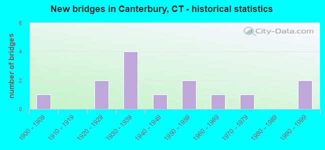
- New bridges - historical statistics
- 11900-1909
- 21920-1929
- 41930-1939
- 11940-1949
- 21950-1959
- 11960-1969
- 11970-1979
- 21990-1999

- Reconstructed bridges - Historical Statistics
- 11940-1949
- 01950-1959
- 01960-1969
- 21970-1979
- 31980-1989
- 11990-1999
- 22000-2009


- Bridge Condition - Deck
- 18.2%Very good
- 54.5%Good
- 9.1%Satisfactory
- 9.1%Fair
- 9.1%Poor

- Bridge Condition - Superstructure
- 8.3%Very good
- 25.0%Good
- 33.3%Satisfactory
- 16.7%Fair
- 16.7%Poor

- Bridge Condition - Substructure
- 8.3%Very good
- 25.0%Good
- 58.3%Satisfactory
- 8.3%Poor

- Bridge Condition - Channel
- 30.8%Good
- 53.8%Satisfactory
- 15.4%Poor

- Bridge Condition - Culverts
- 50.0%Good
- 50.0%Fair
Find on map >> Show street view
Structure Number: 46, Location: 275 FT N OF ROUTE 136 (Lat: 41.077556, Lng: -73.464392), Route carried "on" structure: Interstate 95, Year Built: 1954, Year Reconstructed: 1991, Status: Open, Structure Length: 5.94m (19.49ft), Average Daily Traffic: 138,700 (year 2017), Truck Traffic: 14%, Average Future Daily Traffic: 206,094 (year 2037), Design Load: HS 20, Features Intersected: METRO NORTH RAILROAD
Minimum Vertical Clearance: 30+ m (98+ ft), Kilometerpoint: 19.763, Lanes on structure: 6, Base Highway Network: Yes, Owner: State Highway Agency, Approaching Roadway Width: 33.2m (108.9ft), Skew: 32 degrees, Material/Design: Steel continuous, Design/Construction: Stringer/Multi-beam, Number Of Spans In Main Unit: 3, Length of Maximum Span: 21.3m (69.9ft), Curb-To-Curb Width: 33.1m (108.6ft), Out-to-Out Width: 36.2m (118.8ft)
Condition: Deck: Good, Superstructure: Satisfactory, Substructure: Satisfactory, Operating Rating: 60.6 metric tons, Method Used To Determine Operating Rating: Load and Resistance Factor Rating (LRFR) rating reported by rating factor(RF) method using HL-93 loadings, Inventory Rating: 47.0 metric tons, Method Used To Determine Inventory Rating: Load and Resistance Factor Rating (LRFR) rating reported by rating factor(RF) method using HL-93 loadings, Structural Evaluation: Equal to present minimum criteria, Deck Geometry: Superior to present desirable criteria, Underclear: Meets minimum limits, Approach Roadway Alignment: Equal to present desirable criteria, Designated Inspection Frequency: Every 24 months, Critical Feature Inspection Frequency: Every 24 months, Inspection Date: November 2020, Critical Feature Inspection Date: November 2020, Deck Structure Type: Concrete Cast-file-Place, Wearing Surface/Protective System: Wearing Surface: Bituminous, Membrane: Built-up, Deck Protection: Epoxy Coated Reinforcing
Find on map >> Show street view
Structure Number: 682, Location: .8 MI EAST OF RTE 97 (Lat: 41.702439, Lng: -72.054806), Route carried "on" structure: State highway 14, Year Built: 1928, Status: Open, Structure Length: 1.57m (5.15ft), Average Daily Traffic: 3,600 (year 2016), Truck Traffic: 3%, Average Future Daily Traffic: 5,349 (year 2036), Design Load: H 15, Features Intersected: LITTLE RIVER
Minimum Vertical Clearance: 30+ m (98+ ft), Kilometerpoint: 13.116, Lanes on structure: 2, Owner: State Highway Agency, Approaching Roadway Width: 8.5m (27.9ft), Material/Design: Concrete, Design/Construction: Frame, Number Of Spans In Main Unit: 1, Length of Maximum Span: 13.7m (44.9ft), Curb-To-Curb Width: 8.5m (27.9ft), Out-to-Out Width: 9.3m (30.5ft)
Condition: Superstructure: Satisfactory, Substructure: Satisfactory, Channel: Satisfactory, Operating Rating: 42.6 metric tons, Method Used To Determine Operating Rating: Field evaluation and documented engineering judgment, Inventory Rating: 32.7 metric tons, Method Used To Determine Inventory Rating: Field evaluation and documented engineering judgment, Structural Evaluation: Equal to present minimum criteria, Deck Geometry: Meets minimum limits, Waterway Adequacy: Better than present minimum criteria, Approach Roadway Alignment: Somewhat better than minimum adequacy, Designated Inspection Frequency: Every 24 months, Inspection Date: June 2020, Wearing Surface/Protective System: Wearing Surface: Bituminous
Find on map >> Show street view
Structure Number: 683, Location: 1 MI WEST OF ROUTE 169 (Lat: 41.697275, Lng: -71.989428), Route carried "on" structure: State highway 14, Year Built: 1962, Year Reconstructed: 1994, Status: Open, Structure Length: 1.01m (3.31ft), Average Daily Traffic: 6,300 (year 2015), Truck Traffic: 3%, Average Future Daily Traffic: 9,361 (year 2035), Design Load: HS 20, Features Intersected: KITT BROOK
Minimum Vertical Clearance: 30+ m (98+ ft), Kilometerpoint: 19.248, Lanes on structure: 2, Owner: State Highway Agency, Approaching Roadway Width: 12.8m (42.0ft), Material/Design: Prestressed concrete, Design/Construction: Slab, Number Of Spans In Main Unit: 1, Length of Maximum Span: 9.1m (29.9ft), Curb-To-Curb Width: 12.7m (41.7ft), Out-to-Out Width: 13.9m (45.6ft)
Condition: Deck: Very good, Superstructure: Very good, Substructure: Good, Channel: Good, Operating Rating: 47.3 metric tons, Method Used To Determine Operating Rating: Load and Resistance Factor Rating (LRFR) rating reported by rating factor(RF) method using HL-93 loadings, Inventory Rating: 36.6 metric tons, Method Used To Determine Inventory Rating: Load and Resistance Factor Rating (LRFR) rating reported by rating factor(RF) method using HL-93 loadings, Structural Evaluation: Better than present minimum criteria, Deck Geometry: Somewhat better than minimum adequacy, Waterway Adequacy: Better than present minimum criteria, Approach Roadway Alignment: Equal to present desirable criteria, Designated Inspection Frequency: Every 48 months, Inspection Date: April 2018, Deck Structure Type: Other, Wearing Surface/Protective System: Wearing Surface: Bituminous, Membrane: Preformed Fabric
Find on map >> Show street view
Structure Number: 684, Location: 0.4 MI E OF ROUTE 169 (Lat: 41.697858, Lng: -71.962664), Route carried "on" structure: State highway 14, Year Built: 1951, Year Reconstructed: 1984, Status: Open, Structure Length: 9.36m (30.71ft), Average Daily Traffic: 5,600 (year 2016), Truck Traffic: 3%, Average Future Daily Traffic: 8,321 (year 2036), Design Load: H 20, Features Intersected: QUINNEBAUG RIVER
Minimum Vertical Clearance: 30+ m (98+ ft), Kilometerpoint: 21.517, Lanes on structure: 2, Owner: State Highway Agency, Approaching Roadway Width: 9.8m (32.2ft), Skew: 3 degrees, Material/Design: Steel continuous, Design/Construction: Stringer/Multi-beam, Number Of Spans In Main Unit: 2, Length of Maximum Span: 45.7m (149.9ft), Curb-To-Curb Width: 9.8m (32.2ft), Out-to-Out Width: 11.0m (36.1ft)
Condition: Deck: Good, Superstructure: Satisfactory, Substructure: Satisfactory, Channel: Good, Operating Rating: 32.7 metric tons, Method Used To Determine Operating Rating: Load and Resistance Factor Rating (LRFR) rating reported by rating factor(RF) method using HL-93 loadings, Inventory Rating: 25.3 metric tons, Method Used To Determine Inventory Rating: Load and Resistance Factor Rating (LRFR) rating reported by rating factor(RF) method using HL-93 loadings, Structural Evaluation: Equal to present minimum criteria, Deck Geometry: Meets minimum limits, Waterway Adequacy: Equal to present desirable criteria, Approach Roadway Alignment: Somewhat better than minimum adequacy, Designated Inspection Frequency: Every 24 months, Underwater Inspection Frequency: Every 48 months, Inspection Date: December 2020, Underwater Inspection Date: October 2020, Deck Structure Type: Concrete Cast-file-Place, Wearing Surface/Protective System: Wearing Surface: Bituminous, Membrane: Preformed Fabric
Find on map >> Show street view
Structure Number: 1417, Location: 1 MI S OF SR 668 (Lat: 41.642408, Lng: -71.990242), Route carried "on" structure: State highway 169, Year Built: 1931, Status: Open, Structure Length: 0.76m (2.49ft), Average Daily Traffic: 3,300 (year 2017), Truck Traffic: 3%, Average Future Daily Traffic: 4,903 (year 2037), Design Load: H 20, Features Intersected: CORY BROOK
Minimum Vertical Clearance: 30+ m (98+ ft), Kilometerpoint: 15.578, Lanes on structure: 2, Owner: State Highway Agency, Approaching Roadway Width: 8.2m (26.9ft), Skew: 1 degrees, Material/Design: Concrete, Design/Construction: Slab, Number Of Spans In Main Unit: 1, Length of Maximum Span: 6.1m (20.0ft), Curb-To-Curb Width: 8.5m (27.9ft), Out-to-Out Width: 9.3m (30.5ft)
Condition: Deck: Fair, Superstructure: Fair, Substructure: Satisfactory, Channel: Satisfactory, Operating Rating: 68.9 metric tons, Method Used To Determine Operating Rating: Load Factor (LF), Inventory Rating: 40.8 metric tons, Method Used To Determine Inventory Rating: Load Factor (LF), Structural Evaluation: Somewhat better than minimum adequacy, Deck Geometry: Meets minimum limits, Waterway Adequacy: Better than present minimum criteria, Approach Roadway Alignment: Better than present minimum criteria, Designated Inspection Frequency: Every 24 months, Inspection Date: September 2021, Deck Structure Type: Concrete Cast-file-Place, Wearing Surface/Protective System: Wearing Surface: Bituminous, Membrane: Preformed Fabric
Find on map >> Show street view
Structure Number: 1649, Location: 0.4 MI FROM ROUTE 169 (Lat: 41.651375, Lng: -71.970764), Route carried "on" structure: State highway 668, Year Built: 1937, Year Reconstructed: 2009, Status: Open, Structure Length: 7.13m (23.39ft), Average Daily Traffic: 2,200 (year 2016), Truck Traffic: 6%, Average Future Daily Traffic: 3,269 (year 2036), Design Load: H 20, Features Intersected: QUINEBAUG RIVER
Minimum Vertical Clearance: 4.80m (15.75ft), Kilometerpoint: 0.708, Lanes on structure: 2, Owner: State Highway Agency, Approaching Roadway Width: 8.5m (27.9ft), Material/Design: Steel, Design/Construction: Truss - Thru, Number Of Spans In Main Unit: 1, Length of Maximum Span: 68.9m (226.0ft), Curb-To-Curb Width: 8.5m (27.9ft), Out-to-Out Width: 9.4m (30.8ft)
Condition: Deck: Good, Superstructure: Fair, Substructure: Satisfactory, Channel: Satisfactory, Operating Rating: 65.9 metric tons, Method Used To Determine Operating Rating: Load Factor (LF), Inventory Rating: 39.5 metric tons, Method Used To Determine Inventory Rating: Load Factor (LF), Structural Evaluation: Somewhat better than minimum adequacy, Deck Geometry: Meets minimum limits, Waterway Adequacy: Better than present minimum criteria, Approach Roadway Alignment: Equal to present minimum criteria, Designated Inspection Frequency: Every 24 months, Critical Feature Inspection Frequency: Every 24 months, Underwater Inspection Frequency: Every 24 months, Inspection Date: December 2020, Critical Feature Inspection Date: December 2020, Underwater Inspection Date: October 2020, Deck Structure Type: Concrete Cast-file-Place, Wearing Surface/Protective System: Wearing Surface: Bituminous, Membrane: Built-up, Deck Protection: Epoxy Coated Reinforcing
Find on map >> Show street view
Structure Number: 4424, Location: 0.5 MI SOUTH OF ROUTE 14 (Lat: 41.693278, Lng: -72.049231), Route carried "on" structure: City street , Year Built: 1930, Year Reconstructed: 1984, Status: Posted for load, Structure Length: 1.13m (3.71ft), Average Daily Traffic: 172 (year 2021), Truck Traffic: 7%, Average Future Daily Traffic: 256 (year 2041), Design Load: HS 20, Features Intersected: LITTLE RIVER, Facility Carried by Structure: MILLER-GOODWIN CON
Minimum Vertical Clearance: 30+ m (98+ ft), Kilometerpoint: 0.113, Lanes on structure: 2, Owner: Town or Township Highway Agency, Approaching Roadway Width: 7.9m (25.9ft), Material/Design: Steel, Design/Construction: Stringer/Multi-beam, Number Of Spans In Main Unit: 1, Length of Maximum Span: 9.8m (32.2ft), Curb-To-Curb Width: 5.7m (18.7ft), Out-to-Out Width: 6.1m (20.0ft)
Condition: Deck: Good, Superstructure: Poor, Substructure: Satisfactory, Channel: Satisfactory, Operating Rating: 41.5 metric tons, Method Used To Determine Operating Rating: Load Factor (LF), Inventory Rating: 24.9 metric tons, Method Used To Determine Inventory Rating: Load Factor (LF), Structural Evaluation: Meets minimum limits, Deck Geometry: High priority of corrective action, Waterway Adequacy: Equal to present minimum criteria, Approach Roadway Alignment: High priority of corrective action, Bridge Posting: Required (Relationship of Operating Rating to Maximum Legal Load: 0.1 - 9.9% below), Designated Inspection Frequency: Every 24 months, Inspection Date: March 2021, Deck Structure Type: Wood or Timber, Wearing Surface/Protective System: Wearing Surface: Bituminous, Membrane: Preformed Fabric, Deck Protection: Other
Find on map >> Show street view
Structure Number: 4598, Location: 3400FT FR JCT ROUTE 169 (Lat: 41.740708, Lng: -71.948717), Route carried "on" structure: City street , Year Built: 1930, Year Reconstructed: 1990, Status: Open, Structure Length: 1.55m (5.09ft), Average Daily Traffic: 550 (year 2019), Truck Traffic: 2%, Average Future Daily Traffic: 817 (year 2039), Design Load: HS 20, Features Intersected: BLACKWELL BROOK, Facility Carried by Structure: WAUREGAN ROAD
Minimum Vertical Clearance: 30+ m (98+ ft), Kilometerpoint: 0.290, Lanes on structure: 2, Owner: Town or Township Highway Agency, Approaching Roadway Width: 8.8m (28.9ft), Material/Design: Prestressed concrete, Design/Construction: Box Beam or Girders - Multiple, Number Of Spans In Main Unit: 1, Length of Maximum Span: 13.7m (44.9ft), Curb-To-Curb Width: 8.8m (28.9ft), Out-to-Out Width: 9.8m (32.2ft)
Condition: Deck: Very good, Superstructure: Good, Substructure: Very good, Channel: Satisfactory, Operating Rating: 42.6 metric tons, Method Used To Determine Operating Rating: Field evaluation and documented engineering judgment, Inventory Rating: 32.7 metric tons, Method Used To Determine Inventory Rating: Field evaluation and documented engineering judgment, Structural Evaluation: Better than present minimum criteria, Deck Geometry: Somewhat better than minimum adequacy, Waterway Adequacy: Equal to present desirable criteria, Approach Roadway Alignment: Equal to present desirable criteria, Designated Inspection Frequency: Every 24 months, Inspection Date: March 2021, Deck Structure Type: Other, Wearing Surface/Protective System: Wearing Surface: Bituminous, Membrane: Preformed Fabric, Deck Protection: Epoxy Coated Reinforcing
Find on map >> Show street view
Structure Number: 4599, Location: 0.5 MI WEST OF ROUTE 169 (Lat: 41.652358, Lng: -71.995333), Route carried "on" structure: City street , Year Built: 1940, Year Reconstructed: 2000, Status: Open, Structure Length: 0.70m (2.30ft), Average Daily Traffic: 398 (year 2019), Truck Traffic: 7%, Average Future Daily Traffic: 591 (year 2039), Design Load: HS 20, Features Intersected: CORY BROOK, Facility Carried by Structure: GOOSENECK HILL RD
Minimum Vertical Clearance: 30+ m (98+ ft), Kilometerpoint: 0.402, Lanes on structure: 2, Owner: Town or Township Highway Agency, Approaching Roadway Width: 5.2m (17.1ft), Skew: 2 degrees, Material/Design: Steel, Design/Construction: Stringer/Multi-beam, Number Of Spans In Main Unit: 1, Length of Maximum Span: 6.4m (21.0ft), Curb-To-Curb Width: 7.3m (24.0ft), Out-to-Out Width: 7.3m (24.0ft)
Condition: Deck: Good, Superstructure: Good, Substructure: Satisfactory, Channel: Satisfactory, Operating Rating: 66.7 metric tons, Method Used To Determine Operating Rating: Load Factor (LF), Inventory Rating: 40.0 metric tons, Method Used To Determine Inventory Rating: Load Factor (LF), Structural Evaluation: Equal to present minimum criteria, Deck Geometry: Somewhat better than minimum adequacy, Waterway Adequacy: Equal to present minimum criteria, Approach Roadway Alignment: Better than present minimum criteria, Designated Inspection Frequency: Every 24 months, Inspection Date: March 2021, Deck Structure Type: Corrugated Steel, Wearing Surface/Protective System: Wearing Surface: Bituminous
Find on map >> Show street view
Structure Number: 46, Location: 50 FT E JCT HANOVER ROAD (Lat: 41.670258, Lng: -72.053853), Route carried "on" structure: City street , Year Built: 1900, Year Reconstructed: 1946, Status: Open, Structure Length: 1.16m (3.81ft), Average Daily Traffic: 1,155 (year 2021), Truck Traffic: 7%, Average Future Daily Traffic: 1,716 (year 2041), Design Load: HS 20, Features Intersected: LITTLE RIVER, Facility Carried by Structure: WOODCHUCK HILL RD
Minimum Vertical Clearance: 30+ m (98+ ft), Kilometerpoint: 0.000, Lanes on structure: 2, Owner: Town or Township Highway Agency, Approaching Roadway Width: 6.1m (20.0ft), Material/Design: Steel, Design/Construction: Stringer/Multi-beam, Number Of Spans In Main Unit: 1, Length of Maximum Span: 10.1m (33.1ft), Curb-To-Curb Width: 6.1m (20.0ft), Out-to-Out Width: 7.5m (24.6ft)
Condition: Deck: Poor, Superstructure: Poor, Substructure: Good, Channel: Good, Operating Rating: 19.1 metric tons, Method Used To Determine Operating Rating: Load and Resistance Factor Rating (LRFR) rating reported by rating factor(RF) method using HL-93 loadings, Inventory Rating: 14.9 metric tons, Method Used To Determine Inventory Rating: Load and Resistance Factor Rating (LRFR) rating reported by rating factor(RF) method using HL-93 loadings, Structural Evaluation: Meets minimum limits, Deck Geometry: High priority of replacement, Waterway Adequacy: Equal to present minimum criteria, Approach Roadway Alignment: High priority of corrective action, Bridge Posting: Required (Relationship of Operating Rating to Maximum Legal Load: 10.0 - 19.9% below), Designated Inspection Frequency: Every 24 months, Inspection Date: March 2021, Deck Structure Type: Concrete Cast-file-Place, Wearing Surface/Protective System: Wearing Surface: Bituminous
Find on map >> Show street view
Structure Number: 5413, Location: 0.5 MI SOUTH OF ROUTE 14 (Lat: 41.689728, Lng: -71.987878), Route carried "on" structure: City street , Year Built: 1928, Year Reconstructed: 1986, Status: Open, Structure Length: 0.85m (2.79ft), Average Daily Traffic: 169 (year 2019), Truck Traffic: 7%, Average Future Daily Traffic: 251 (year 2039), Design Load: HL 93, Features Intersected: KITT BROOK, Facility Carried by Structure: TRACY ROAD #1
Minimum Vertical Clearance: 30+ m (98+ ft), Kilometerpoint: 24.398, Lanes on structure: 2, Owner: Town or Township Highway Agency, Approaching Roadway Width: 5.5m (18.0ft), Material/Design: Wood or Timber, Design/Construction: Slab, Number Of Spans In Main Unit: 1, Length of Maximum Span: 7.6m (24.9ft), Curb-To-Curb Width: 6.4m (21.0ft), Out-to-Out Width: 6.7m (22.0ft)
Condition: Deck: Satisfactory, Superstructure: Satisfactory, Substructure: Poor, Channel: Satisfactory, Operating Rating: 11.3 metric tons, Method Used To Determine Operating Rating: Load and Resistance Factor Rating (LRFR) rating reported by rating factor(RF) method using HL-93 loadings, Inventory Rating: 8.7 metric tons, Method Used To Determine Inventory Rating: Load and Resistance Factor Rating (LRFR) rating reported by rating factor(RF) method using HL-93 loadings, Structural Evaluation: High priority of corrective action, Deck Geometry: Meets minimum limits, Waterway Adequacy: Somewhat better than minimum adequacy, Approach Roadway Alignment: High priority of corrective action, Bridge Posting: Required (Relationship of Operating Rating to Maximum Legal Load: > 39.9% below), Designated Inspection Frequency: Every 24 months, Inspection Date: March 2021, Deck Structure Type: Wood or Timber, Wearing Surface/Protective System: Wearing Surface: Bituminous, Membrane: Preformed Fabric, Deck Protection: Other
Find on map >> Show street view
Structure Number: 5856, Location: 1 MI SOUTH OF ROUTE 14 (Lat: 41.680025, Lng: -71.967792), Route carried "on" structure: State highway 169, Year Built: 1990, Status: Open, Structure Length: 1.34m (4.40ft), Average Daily Traffic: 3,000 (year 2019), Truck Traffic: 3%, Average Future Daily Traffic: 4,458 (year 2039), Design Load: HS 20, Features Intersected: KITT BROOK
Minimum Vertical Clearance: 30+ m (98+ ft), Kilometerpoint: 20.471, Lanes on structure: 2, Owner: State Highway Agency, Approaching Roadway Width: 7.9m (25.9ft), Skew: 4 degrees, Material/Design: Prestressed concrete, Design/Construction: Slab, Number Of Spans In Main Unit: 1, Length of Maximum Span: 11.9m (39.0ft), Curb-To-Curb Width: 9.4m (30.8ft), Out-to-Out Width: 10.6m (34.8ft)
Condition: Deck: Good, Superstructure: Good, Substructure: Good, Channel: Good, Operating Rating: 67.7 metric tons, Method Used To Determine Operating Rating: Load Factor (LF), Inventory Rating: 39.9 metric tons, Method Used To Determine Inventory Rating: Load Factor (LF), Structural Evaluation: Better than present minimum criteria, Deck Geometry: Meets minimum limits, Waterway Adequacy: Equal to present minimum criteria, Approach Roadway Alignment: Equal to present desirable criteria, Designated Inspection Frequency: Every 24 months, Inspection Date: September 2021, Deck Structure Type: Other, Wearing Surface/Protective System: Wearing Surface: Bituminous, Membrane: Built-up
Find on map >> Show street view
Structure Number: 5857, Location: 3 MI NORTH OF ROUTE 14 (Lat: 41.742231, Lng: -71.960256), Route carried "on" structure: State highway 169, Year Built: 1990, Status: Open, Structure Length: 0.67m (2.20ft), Average Daily Traffic: 2,200 (year 2016), Truck Traffic: 3%, Average Future Daily Traffic: 3,269 (year 2036), Features Intersected: TATNIC BROOK
Minimum Vertical Clearance: 30+ m (98+ ft), Kilometerpoint: 27.858, Lanes on structure: 2, Owner: State Highway Agency, Approaching Roadway Width: 10.4m (34.1ft), Material/Design: Concrete continuous, Design/Construction: Culvert, Number Of Spans In Main Unit: 2, Length of Maximum Span: 3.0m (9.8ft), Curb-To-Curb Width: 10.6m (34.8ft), Out-to-Out Width: 11.6m (38.1ft)
Condition: Channel: Poor, Culverts: Good, Structural Evaluation: Better than present minimum criteria, Deck Geometry: Somewhat better than minimum adequacy, Waterway Adequacy: Better than present minimum criteria, Approach Roadway Alignment: Equal to present desirable criteria, Designated Inspection Frequency: Every 48 months, Inspection Date: August 2021
Find on map >> Show street view
Structure Number: 6193, Location: 1.15 MILES S OF ROUTE 169 (Lat: 41.680681, Lng: -71.977536), Route carried "on" structure: City street , Year Built: 1970, Status: Open, Structure Length: 0.76m (2.49ft), Average Daily Traffic: 169 (year 2019), Truck Traffic: 7%, Average Future Daily Traffic: 251 (year 2039), Features Intersected: KITT BROOK, Facility Carried by Structure: ELMDALE ROAD
Minimum Vertical Clearance: 30+ m (98+ ft), Kilometerpoint: 126.285, Lanes on structure: 2, Owner: Town or Township Highway Agency, Approaching Roadway Width: 6.4m (21.0ft), Material/Design: Concrete, Design/Construction: Culvert, Number Of Spans In Main Unit: 3, Length of Maximum Span: 2.1m (6.9ft)
Condition: Channel: Poor, Culverts: Fair, Operating Rating: 42.6 metric tons, Method Used To Determine Operating Rating: Field evaluation and documented engineering judgment, Inventory Rating: 32.7 metric tons, Method Used To Determine Inventory Rating: Field evaluation and documented engineering judgment, Structural Evaluation: Somewhat better than minimum adequacy, Waterway Adequacy: Better than present minimum criteria, Approach Roadway Alignment: Better than present minimum criteria, Designated Inspection Frequency: Every 24 months, Inspection Date: March 2021