Bridge Statistics for Canton, Missouri (MO)
Condition, Traffic, Stress, Structural Evaluation, Project Costs
- National Bridge Inventory (NBI) Statistics
- 23Number of bridges
- 253ft / 76.9mTotal length
- $898,000Total costs
- 76,681Total average daily traffic
- 24,433Total average daily truck traffic
- National Bridge Inventory (NBI) Registered Bridges for Canton
- No street view available for this location
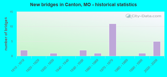
- New bridges - historical statistics
- 21910-1919
- 11930-1939
- 21950-1959
- 11960-1969
- 111970-1979
- 11990-1999
- 52000-2009

- Reconstructed bridges - Historical Statistics
- 11980-1989
- 11990-1999


- Bridge Condition - Deck
- 25.0%Very good
- 16.7%Good
- 25.0%Satisfactory
- 33.3%Fair

- Bridge Condition - Superstructure
- 8.3%Excellent
- 50.0%Good
- 8.3%Satisfactory
- 16.7%Fair
- 16.7%Poor

- Bridge Condition - Substructure
- 8.3%Excellent
- 25.0%Good
- 33.3%Satisfactory
- 25.0%Fair
- 8.3%Poor

- Bridge Condition - Channel
- 7.1%Very good
- 71.4%Satisfactory
- 21.4%Fair
Find on map >> Show street view
Structure Number: 1648, Location: S 17 T 62 N R 6 W (Lat: 40.168250, Lng: -91.586444), Route carried "on" structure: County highway 122, Year Built: 1910, Status: Closed, Structure Length: 2.32m (7.61ft), Average Daily Traffic: 50 (year 2018), Truck Traffic: 10%, Average Future Daily Traffic: 63 (year 2038), Features Intersected: WYACONDA RVR, Facility Carried by Structure: COUNTY RD 429
Minimum Vertical Clearance: 30+ m (98+ ft), Kilometerpoint: 1.127, Lanes on structure: 1, Owner: County Highway Agency, Approaching Roadway Width: 4.9m (16.1ft), Material/Design: Steel, Design/Construction: Truss - Thru, Number Of Spans In Main Unit: 1, Length of Maximum Span: 22.9m (75.1ft), Curb-To-Curb Width: 3.6m (11.8ft), Out-to-Out Width: 3.7m (12.1ft)
Condition: Deck: Satisfactory, Superstructure: Poor, Substructure: Poor, Channel: Satisfactory, Deck Geometry: High priority of corrective action, Waterway Adequacy: Somewhat better than minimum adequacy, Approach Roadway Alignment: Meets minimum limits, Bridge Posting: Required (Relationship of Operating Rating to Maximum Legal Load: > 39.9% below), Length Of Structure Improvement: 0.32m (1.05ft), Designated Inspection Frequency: Every 24 months, Critical Feature Inspection Frequency: Every 24 months, Inspection Date: January 2018, Critical Feature Inspection Date: January 2018, Bridge Improvement Cost: $233,000, Roadway Improvement Cost: $23,000, Total Project Cost: $350,000 ( Estimate for 2022), Deck Structure Type: Wood or Timber, Wearing Surface/Protective System: Wearing Surface: Wood or Timber
Find on map >> Show street view
Structure Number: 16632, Location: S 6 T 61 N R 6 W (Lat: 40.120500, Lng: -91.599472), Route carried "on" structure: County highway 127, Year Built: 1910, Status: Posted for load, Structure Length: 2.47m (8.10ft), Average Daily Traffic: 35 (year 2020), Truck Traffic: 10%, Average Future Daily Traffic: 44 (year 2040), Features Intersected: SUGAR CR, Facility Carried by Structure: COUNTY RD 526
Minimum Vertical Clearance: 30+ m (98+ ft), Kilometerpoint: 1.770, Lanes on structure: 1, Owner: County Highway Agency, Approaching Roadway Width: 4.3m (14.1ft), Material/Design: Steel, Design/Construction: Truss - Thru, Number Of Spans In Main Unit: 1, Length of Maximum Span: 24.4m (80.1ft), Curb-To-Curb Width: 3.7m (12.1ft), Out-to-Out Width: 3.7m (12.1ft)
Condition: Deck: Very good, Superstructure: Poor, Substructure: Fair, Channel: Fair, Operating Rating: 6.3 metric tons, Method Used To Determine Operating Rating: Field evaluation and documented engineering judgment, Inventory Rating: 6.3 metric tons, Method Used To Determine Inventory Rating: Field evaluation and documented engineering judgment, Structural Evaluation: High priority of replacement, Deck Geometry: Meets minimum limits, Waterway Adequacy: Somewhat better than minimum adequacy, Approach Roadway Alignment: Equal to present desirable criteria, Bridge Posting: Required (Relationship of Operating Rating to Maximum Legal Load: > 39.9% below), Length Of Structure Improvement: 0.33m (1.08ft), Designated Inspection Frequency: Every 24 months, Critical Feature Inspection Frequency: Every 24 months, Inspection Date: January 2022, Critical Feature Inspection Date: January 2022, Bridge Improvement Cost: $240,000, Roadway Improvement Cost: $24,000, Total Project Cost: $360,000 ( Estimate for 2022), Deck Structure Type: Concrete Cast-file-Place
Find on map >> Show street view
Structure Number: 16642, Location: S 6 T 61 N R 6 W (Lat: 40.120111, Lng: -91.581361), Route carried "on" structure: County highway 127, Year Built: 1996, Status: Open, Structure Length: 2.29m (7.51ft), Average Daily Traffic: 35 (year 2020), Truck Traffic: 10%, Average Future Daily Traffic: 44 (year 2040), Features Intersected: SUGAR CR, Facility Carried by Structure: COUNTY RD 526
Minimum Vertical Clearance: 30+ m (98+ ft), Kilometerpoint: 3.380, Lanes on structure: 2, Owner: County Highway Agency, Approaching Roadway Width: 5.5m (18.0ft), Material/Design: Steel, Design/Construction: Stringer/Multi-beam, Number Of Spans In Main Unit: 1, Length of Maximum Span: 22.3m (73.2ft), Curb-To-Curb Width: 5.5m (18.0ft), Out-to-Out Width: 5.5m (18.0ft)
Condition: Deck: Good, Superstructure: Good, Substructure: Satisfactory, Channel: Fair, Operating Rating: 72.9 metric tons, Method Used To Determine Operating Rating: Load Factor (LF), Inventory Rating: 41.4 metric tons, Method Used To Determine Inventory Rating: Load Factor (LF), Structural Evaluation: Equal to present minimum criteria, Deck Geometry: Meets minimum limits, Waterway Adequacy: Somewhat better than minimum adequacy, Approach Roadway Alignment: Equal to present minimum criteria, Designated Inspection Frequency: Every 24 months, Inspection Date: January 2022, Deck Structure Type: Concrete Cast-file-Place
Find on map >> Show street view
Structure Number: 2473, Location: S 28 T 62 N R 6 W (Lat: 40.142186, Lng: -91.566000), Route carried "on" structure: State highway 16, Year Built: 1973, Year Reconstructed: 1987, Status: Open, Structure Length: 8.56m (28.08ft), Average Daily Traffic: 1,703 (year 2021), Truck Traffic: 12%, Average Future Daily Traffic: 2,469 (year 2041), Design Load: H 20, Features Intersected: WYACONDA RVR
Minimum Vertical Clearance: 30+ m (98+ ft), Kilometerpoint: 22.558, Lanes on structure: 2, Owner: State Highway Agency, Approaching Roadway Width: 7.3m (24.0ft), Skew: 3 degrees, Material/Design: Steel continuous, Design/Construction: Stringer/Multi-beam, Number Of Spans In Main Unit: 3, Length of Maximum Span: 32.9m (107.9ft), Curb or Sidewalk Widths: Left: 0.2m (0.7ft), Right: 0.2m (0.7ft), Curb-To-Curb Width: 12.2m (40.0ft), Out-to-Out Width: 13.0m (42.7ft)
Condition: Deck: Satisfactory, Superstructure: Good, Substructure: Satisfactory, Channel: Satisfactory, Operating Rating: 36.9 metric tons, Method Used To Determine Operating Rating: Allowable Stress (AS), Inventory Rating: 16.2 metric tons, Method Used To Determine Inventory Rating: Allowable Stress (AS), Structural Evaluation: Meets minimum limits, Deck Geometry: Better than present minimum criteria, Waterway Adequacy: Equal to present desirable criteria, Approach Roadway Alignment: Equal to present desirable criteria, Designated Inspection Frequency: Every 24 months, Inspection Date: October 2020, Deck Structure Type: Concrete Cast-file-Place, Wearing Surface/Protective System: Wearing Surface: Bituminous, Membrane: Built-up
Find on map >> Show street view
Structure Number: 2848, Location: S 34 T 62 N R 6 W (Lat: 40.133983, Lng: -91.540358), Route carried "on" structure: State highway 16, Year Built: 1974, Status: Open, Structure Length: 8.23m (27.00ft), Average Daily Traffic: 2,667 (year 2021), Truck Traffic: 12%, Average Future Daily Traffic: 3,867 (year 2041), Design Load: H 20, Features Intersected: US 61
Minimum Vertical Clearance: 30+ m (98+ ft), Kilometerpoint: 25.017, Lanes on structure: 2, Lanes under structure: 4, Owner: State Highway Agency, Approaching Roadway Width: 13.4m (44.0ft), Skew: 1 degrees, Material/Design: Steel continuous, Design/Construction: Stringer/Multi-beam, Number Of Spans In Main Unit: 2, Length of Maximum Span: 35.3m (115.8ft), Curb-To-Curb Width: 13.4m (44.0ft), Out-to-Out Width: 14.3m (46.9ft)
Condition: Deck: Satisfactory, Superstructure: Good, Substructure: Satisfactory, Operating Rating: 41.4 metric tons, Method Used To Determine Operating Rating: Allowable Stress (AS), Inventory Rating: 25.2 metric tons, Method Used To Determine Inventory Rating: Allowable Stress (AS), Structural Evaluation: Equal to present minimum criteria, Deck Geometry: Better than present minimum criteria, Underclear: Better than present minimum criteria, Approach Roadway Alignment: Equal to present desirable criteria, Designated Inspection Frequency: Every 24 months, Inspection Date: October 2020, Deck Structure Type: Concrete Cast-file-Place, Wearing Surface/Protective System: Wearing Surface: Bituminous
Find on map >> Show street view
Structure Number: 2849, Location: S 34 T 62 N R 6 W (Lat: 40.123283, Lng: -91.541497), Route carried "on" structure: State highway P, Year Built: 1974, Status: Open, Structure Length: 7.86m (25.79ft), Average Daily Traffic: 458 (year 2021), Truck Traffic: 11%, Average Future Daily Traffic: 664 (year 2041), Design Load: H 20, Features Intersected: US 61
Minimum Vertical Clearance: 30+ m (98+ ft), Kilometerpoint: 0.040, Lanes on structure: 2, Lanes under structure: 4, Owner: State Highway Agency, Approaching Roadway Width: 7.3m (24.0ft), Material/Design: Steel continuous, Design/Construction: Stringer/Multi-beam, Number Of Spans In Main Unit: 2, Length of Maximum Span: 33.7m (110.6ft), Curb-To-Curb Width: 12.2m (40.0ft), Out-to-Out Width: 13.0m (42.7ft)
Condition: Deck: Fair, Superstructure: Good, Substructure: Fair, Operating Rating: 40.5 metric tons, Method Used To Determine Operating Rating: Allowable Stress (AS), Inventory Rating: 21.6 metric tons, Method Used To Determine Inventory Rating: Allowable Stress (AS), Structural Evaluation: Somewhat better than minimum adequacy, Deck Geometry: Equal to present desirable criteria, Underclear: Better than present minimum criteria, Approach Roadway Alignment: Equal to present desirable criteria, Designated Inspection Frequency: Every 24 months, Inspection Date: October 2020, Deck Structure Type: Concrete Cast-file-Place, Wearing Surface/Protective System: Wearing Surface: Bituminous
Find on map >> Show street view
Structure Number: 285, Location: S 14 T 61 N R 6 W (Lat: 40.087800, Lng: -91.535192), Route carried "on" structure: County highway , Year Built: 1974, Status: Open, Structure Length: 8.26m (27.10ft), Average Daily Traffic: 140 (year 2021), Truck Traffic: 10%, Average Future Daily Traffic: 203 (year 2041), Design Load: H 15, Features Intersected: US 61, Facility Carried by Structure: SUNFLOWER ST E
Minimum Vertical Clearance: 30+ m (98+ ft), Kilometerpoint: 1.376, Lanes on structure: 2, Lanes under structure: 4, Owner: State Highway Agency, Approaching Roadway Width: 6.1m (20.0ft), Skew: 1 degrees, Material/Design: Steel continuous, Design/Construction: Stringer/Multi-beam, Number Of Spans In Main Unit: 2, Length of Maximum Span: 35.3m (115.8ft), Curb-To-Curb Width: 8.5m (27.9ft), Out-to-Out Width: 9.4m (30.8ft)
Condition: Deck: Very good, Superstructure: Good, Substructure: Good, Operating Rating: 33.3 metric tons, Method Used To Determine Operating Rating: Allowable Stress (AS), Inventory Rating: 18.0 metric tons, Method Used To Determine Inventory Rating: Allowable Stress (AS), Structural Evaluation: Somewhat better than minimum adequacy, Deck Geometry: Equal to present minimum criteria, Underclear: Equal to present desirable criteria, Approach Roadway Alignment: Equal to present desirable criteria, Designated Inspection Frequency: Every 24 months, Inspection Date: October 2020, Deck Structure Type: Concrete Cast-file-Place, Wearing Surface/Protective System: Wearing Surface: Monolithic Concrete
Find on map >> Show street view
Structure Number: 2851, Location: S 14 T 61 N R 6 W (Lat: 40.084317, Lng: -91.535933), Route carried "on" structure: US 61, Year Built: 1974, Year Reconstructed: 2004, Status: Open, Structure Length: 8.78m (28.81ft), Average Daily Traffic: 5,792 (year 2021), Truck Traffic: 38%, Average Future Daily Traffic: 11,005 (year 2041), Design Load: HS 20, Features Intersected: WYACONDA RVR
Minimum Vertical Clearance: 30+ m (98+ ft), Kilometerpoint: 46.615, Lanes on structure: 2, Base Highway Network: Yes, Owner: State Highway Agency, Approaching Roadway Width: 12.2m (40.0ft), Skew: 1 degrees, Material/Design: Steel continuous, Design/Construction: Stringer/Multi-beam, Number Of Spans In Main Unit: 3, Length of Maximum Span: 34.1m (111.9ft), Curb-To-Curb Width: 13.4m (44.0ft), Out-to-Out Width: 14.3m (46.9ft)
Condition: Deck: Fair, Superstructure: Fair, Substructure: Satisfactory, Channel: Satisfactory, Operating Rating: 53.1 metric tons, Method Used To Determine Operating Rating: Load Factor (LF), Inventory Rating: 32.4 metric tons, Method Used To Determine Inventory Rating: Load Factor (LF), Structural Evaluation: Somewhat better than minimum adequacy, Deck Geometry: Superior to present desirable criteria, Waterway Adequacy: Equal to present desirable criteria, Approach Roadway Alignment: Equal to present desirable criteria, Designated Inspection Frequency: Every 24 months, Inspection Date: November 2020, Deck Structure Type: Concrete Cast-file-Place, Wearing Surface/Protective System: Wearing Surface: Epoxy Overlay, Deck Protection: Internally Sealed
Find on map >> Show street view
Structure Number: 29111, Location: S 14 T 61 N R 6 W (Lat: 40.084311, Lng: -91.535622), Route carried "on" structure: US 61, Year Built: 2001, Status: Open, Structure Length: 8.69m (28.51ft), Average Daily Traffic: 5,899 (year 2021), Truck Traffic: 33%, Average Future Daily Traffic: 11,208 (year 2041), Design Load: HS 25 or greater, Features Intersected: WACONDA RVR
Minimum Vertical Clearance: 30+ m (98+ ft), Kilometerpoint: 587.410, Lanes on structure: 2, Base Highway Network: Yes, Owner: State Highway Agency, Approaching Roadway Width: 12.0m (39.4ft), Skew: 1 degrees, Material/Design: Steel continuous, Design/Construction: Stringer/Multi-beam, Number Of Spans In Main Unit: 3, Length of Maximum Span: 34.0m (111.5ft), Curb-To-Curb Width: 11.4m (37.4ft), Out-to-Out Width: 12.2m (40.0ft)
Condition: Deck: Good, Superstructure: Excellent, Substructure: Excellent, Channel: Satisfactory, Operating Rating: 91.8 metric tons, Method Used To Determine Operating Rating: Load Factor (LF), Inventory Rating: 55.8 metric tons, Method Used To Determine Inventory Rating: Load Factor (LF), Structural Evaluation: Superior to present desirable criteria, Deck Geometry: Equal to present minimum criteria, Waterway Adequacy: Superior to present desirable criteria, Approach Roadway Alignment: Equal to present desirable criteria, Designated Inspection Frequency: Every 24 months, Inspection Date: October 2020, Deck Structure Type: Concrete Cast-file-Place, Wearing Surface/Protective System: Wearing Surface: Monolithic Concrete, Deck Protection: Epoxy Coated Reinforcing
Find on map >> Show street view
Structure Number: 30148, Location: S 11 T 61 N R 6 W (Lat: 40.093028, Lng: -91.514861), Route carried "on" structure: County highway 207, Year Built: 2003, Status: Open, Structure Length: 0.76m (2.49ft), Average Daily Traffic: 35 (year 2020), Truck Traffic: 10%, Average Future Daily Traffic: 44 (year 2040), Features Intersected: BRANCH, Facility Carried by Structure: COUNTY RD 552
Minimum Vertical Clearance: 30+ m (98+ ft), Kilometerpoint: 5.150, Lanes on structure: 2, Owner: County Highway Agency, Approaching Roadway Width: 5.5m (18.0ft), Material/Design: Concrete, Design/Construction: Slab, Number Of Spans In Main Unit: 1, Length of Maximum Span: 7.3m (24.0ft), Curb-To-Curb Width: 6.9m (22.6ft), Out-to-Out Width: 7.0m (23.0ft)
Condition: Deck: Very good, Superstructure: Satisfactory, Substructure: Good, Channel: Satisfactory, Operating Rating: 64.8 metric tons, Method Used To Determine Operating Rating: Load Factor (LF), Inventory Rating: 38.7 metric tons, Method Used To Determine Inventory Rating: Load Factor (LF), Structural Evaluation: Equal to present minimum criteria, Deck Geometry: Somewhat better than minimum adequacy, Waterway Adequacy: Equal to present minimum criteria, Approach Roadway Alignment: Equal to present desirable criteria, Designated Inspection Frequency: Every 24 months, Inspection Date: January 2022, Deck Structure Type: Concrete Precast Panels
Find on map >> Show street view
Structure Number: 31046, Location: S 14 T 62 N R 6 W (Lat: 40.173244, Lng: -91.526814), Route carried "on" structure: US 61, Year Built: 2005, Status: Open, Structure Length: 0.91m (2.99ft), Average Daily Traffic: 7,557 (year 2021), Truck Traffic: 32%, Average Future Daily Traffic: 14,358 (year 2041), Design Load: HS 25 or greater, Features Intersected: ARTESIAN BR CR
Minimum Vertical Clearance: 30+ m (98+ ft), Kilometerpoint: 36.447, Lanes on structure: 8, Base Highway Network: Yes, Owner: State Highway Agency, Approaching Roadway Width: 25.0m (82.0ft), Skew: 1 degrees, Material/Design: Concrete continuous, Design/Construction: Culvert, Number Of Spans In Main Unit: 3, Length of Maximum Span: 2.7m (8.9ft)
Condition: Channel: Satisfactory, Culverts: Satisfactory, Inventory Rating: 93.6 metric tons, Method Used To Determine Inventory Rating: Load Factor (LF), Structural Evaluation: Equal to present minimum criteria, Waterway Adequacy: Superior to present desirable criteria, Approach Roadway Alignment: Equal to present desirable criteria, Designated Inspection Frequency: Every 24 months, Inspection Date: October 2020
Find on map >> Show street view
Structure Number: 31049, Location: S 11 T 62 N R 6 W (Lat: 40.177789, Lng: -91.524744), Route carried "on" structure: US 61, Year Built: 2005, Status: Open, Structure Length: 1.52m (4.99ft), Average Daily Traffic: 9,735 (year 2021), Truck Traffic: 32%, Average Future Daily Traffic: 18,497 (year 2041), Design Load: HS 25 or greater, Features Intersected: BLAND BR CK
Minimum Vertical Clearance: 30+ m (98+ ft), Kilometerpoint: 35.909, Lanes on structure: 4, Base Highway Network: Yes, Owner: State Highway Agency, Approaching Roadway Width: 23.2m (76.1ft), Skew: 2 degrees, Material/Design: Concrete continuous, Design/Construction: Culvert, Number Of Spans In Main Unit: 3, Length of Maximum Span: 4.3m (14.1ft)
Condition: Channel: Satisfactory, Culverts: Satisfactory, Inventory Rating: 64.8 metric tons, Method Used To Determine Inventory Rating: Field evaluation and documented engineering judgment, Structural Evaluation: Equal to present minimum criteria, Waterway Adequacy: Superior to present desirable criteria, Approach Roadway Alignment: Equal to present desirable criteria, Designated Inspection Frequency: Every 24 months, Inspection Date: October 2020
Find on map >> Show street view
Structure Number: 3105, Location: S 2 T 62 N R 6 W (Lat: 40.194972, Lng: -91.521739), Route carried "on" structure: US 61, Year Built: 2005, Status: Open, Structure Length: 0.64m (2.10ft), Average Daily Traffic: 9,735 (year 2021), Truck Traffic: 32%, Average Future Daily Traffic: 18,497 (year 2041), Design Load: HS 25 or greater, Features Intersected: UNNAMED CR
Minimum Vertical Clearance: 30+ m (98+ ft), Kilometerpoint: 33.952, Lanes on structure: 4, Base Highway Network: Yes, Owner: State Highway Agency, Approaching Roadway Width: 23.2m (76.1ft), Material/Design: Concrete continuous, Design/Construction: Culvert, Number Of Spans In Main Unit: 2, Length of Maximum Span: 3.0m (9.8ft)
Condition: Channel: Satisfactory, Culverts: Satisfactory, Inventory Rating: 64.8 metric tons, Method Used To Determine Inventory Rating: Field evaluation and documented engineering judgment, Structural Evaluation: Equal to present minimum criteria, Waterway Adequacy: Superior to present desirable criteria, Approach Roadway Alignment: Equal to present desirable criteria, Designated Inspection Frequency: Every 24 months, Inspection Date: October 2020
Find on map >> Show street view
Structure Number: 7687, Location: S 3241 T 41 N R 20 W (Lat: 38.277367, Lng: -93.151111), Route carried "on" structure: State highway B, Year Built: 1954, Status: Open, Structure Length: 0.90m (2.95ft), Average Daily Traffic: 248 (year 2021), Truck Traffic: 11%, Average Future Daily Traffic: 397 (year 2041), Design Load: H 10, Features Intersected: KNOBBY CR
Minimum Vertical Clearance: 30+ m (98+ ft), Kilometerpoint: 23.928, Lanes on structure: 2, Owner: State Highway Agency, Approaching Roadway Width: 7.3m (24.0ft), Skew: 4 degrees, Material/Design: Concrete continuous, Design/Construction: Culvert, Number Of Spans In Main Unit: 2, Length of Maximum Span: 3.4m (11.2ft), Curb-To-Curb Width: 7.3m (24.0ft), Out-to-Out Width: 7.9m (25.9ft)
Condition: Channel: Fair, Culverts: Satisfactory, Operating Rating: 39.6 metric tons, Method Used To Determine Operating Rating: Load Factor (LF), Inventory Rating: 23.4 metric tons, Method Used To Determine Inventory Rating: Load Factor (LF), Structural Evaluation: Equal to present minimum criteria, Deck Geometry: Somewhat better than minimum adequacy, Waterway Adequacy: Equal to present minimum criteria, Approach Roadway Alignment: Equal to present minimum criteria, Designated Inspection Frequency: Every 24 months, Inspection Date: March 2021
Find on map >> Show street view
Structure Number: 7823, Location: S 10 T 52 N R 9 W (Lat: 39.294656, Lng: -91.910308), Route carried "on" structure: State highway Z, Year Built: 1954, Status: Open, Structure Length: 0.75m (2.46ft), Average Daily Traffic: 277 (year 2021), Truck Traffic: 11%, Average Future Daily Traffic: 402 (year 2041), Design Load: H 10, Features Intersected: FIVE MILE CR
Minimum Vertical Clearance: 30+ m (98+ ft), Kilometerpoint: 21.102, Lanes on structure: 2, Owner: State Highway Agency, Approaching Roadway Width: 7.3m (24.0ft), Material/Design: Concrete continuous, Design/Construction: Culvert, Number Of Spans In Main Unit: 2, Length of Maximum Span: 3.7m (12.1ft), Curb-To-Curb Width: 7.3m (24.0ft), Out-to-Out Width: 7.9m (25.9ft)
Condition: Channel: Satisfactory, Culverts: Satisfactory, Operating Rating: 34.2 metric tons, Method Used To Determine Operating Rating: Load Factor (LF), Inventory Rating: 20.7 metric tons, Method Used To Determine Inventory Rating: Load Factor (LF), Structural Evaluation: Equal to present minimum criteria, Deck Geometry: Somewhat better than minimum adequacy, Waterway Adequacy: Equal to present minimum criteria, Approach Roadway Alignment: Better than present minimum criteria, Designated Inspection Frequency: Every 24 months, Inspection Date: October 2021
Find on map >> Show street view
Structure Number: 8186, Location: S 33 T 62 N R 6 W (Lat: 40.121261, Lng: -91.565883), Route carried "on" structure: State highway P, Year Built: 1963, Status: Posted for load, Structure Length: 10.39m (34.09ft), Average Daily Traffic: 458 (year 2021), Truck Traffic: 11%, Average Future Daily Traffic: 664 (year 2041), Design Load: H 15, Features Intersected: WYACONDA RVR
Minimum Vertical Clearance: 30+ m (98+ ft), Kilometerpoint: 2.192, Lanes on structure: 1, Owner: State Highway Agency, Approaching Roadway Width: 6.1m (20.0ft), Material/Design: Steel continuous, Design/Construction: Stringer/Multi-beam, Number Of Spans In Main Unit: 4, Length of Maximum Span: 31.7m (104.0ft), Curb-To-Curb Width: 6.7m (22.0ft), Out-to-Out Width: 7.4m (24.3ft)
Condition: Deck: Fair, Superstructure: Good, Substructure: Good, Channel: Satisfactory, Operating Rating: 20.7 metric tons, Method Used To Determine Operating Rating: Load Factor (LF), Inventory Rating: 12.6 metric tons, Method Used To Determine Inventory Rating: Load Factor (LF), Structural Evaluation: Meets minimum limits, Deck Geometry: Meets minimum limits, Waterway Adequacy: Equal to present desirable criteria, Approach Roadway Alignment: Meets minimum limits, Bridge Posting: Required (Relationship of Operating Rating to Maximum Legal Load: 20.0 - 29.9% below), Designated Inspection Frequency: Every 24 months, Inspection Date: October 2020, Deck Structure Type: Concrete Cast-file-Place, Wearing Surface/Protective System: Wearing Surface: Bituminous
Find on map >> Show street view
Structure Number: CEPNCRMO-000003, Location: L/D No. 20, Canton, MO (Lat: 40.140522, Lng: -91.516008), Route carried "on" structure: Federal lands road , Year Built: 1937, Status: Open, Structure Length: 3.56m (11.68ft), Average Daily Traffic: 100 (year 2020), Truck Traffic: 5%, Average Future Daily Traffic: 100 (year 2039), Design Load: H 15, Features Intersected: Canton Creek, Facility Carried by Structure: Lock Access Road
Minimum Vertical Clearance: 30+ m (98+ ft), Kilometerpoint: 0.000, Lanes on structure: 2, Owner: Corps of Engineers (Civil), Approaching Roadway Width: 7.0m (23.0ft), Material/Design: Concrete, Design/Construction: Arch - Deck, Number Of Spans In Main Unit: 1, Length of Maximum Span: 30.5m (100.1ft), Curb or Sidewalk Widths: Left: 0.4m (1.3ft), Right: 0.4m (1.3ft), Curb-To-Curb Width: 6.0m (19.7ft), Out-to-Out Width: 7.0m (23.0ft)
Condition: Deck: Fair, Superstructure: Fair, Substructure: Fair, Channel: Very good, Operating Rating: 39.2 metric tons, Method Used To Determine Operating Rating: Load and Resistance Factor Rating (LRFR) rating reported by rating factor(RF) method using HL-93 loadings, Inventory Rating: 30.1 metric tons, Method Used To Determine Inventory Rating: Load and Resistance Factor Rating (LRFR) rating reported by rating factor(RF) method using HL-93 loadings, Structural Evaluation: Somewhat better than minimum adequacy, Deck Geometry: Meets minimum limits, Waterway Adequacy: Better than present minimum criteria, Approach Roadway Alignment: Somewhat better than minimum adequacy, Length Of Structure Improvement: 3.56m (11.68ft), Designated Inspection Frequency: Every 24 months, Inspection Date: July 2020, Bridge Improvement Cost: $125,000, Roadway Improvement Cost: $13,000, Total Project Cost: $188,000 ( Estimate for 2020), Deck Structure Type: Concrete Cast-file-Place, Wearing Surface/Protective System: Wearing Surface: Bituminous
Find on map >> Show street view
Structure Number: 2848, Location: S 34 T 62 N R 6 W (Lat: 40.133983, Lng: -91.540358), Route carried "under" structure: US 61, Year Built: 1974, Structure Length: 0. m, Average Daily Traffic: 4,627 (year 2021), Truck Traffic: 31%, Features Intersected: US 61, Facility Carried by Structure: MO 16 E
Minimum Vertical Clearance: 5.61m (18.41ft), Kilometerpoint: 593.109, Lanes on structure: 2, Lanes under structure: 2, Material/Design: Steel continuous, Design/Construction: Stringer/Multi-beam, Length of Maximum Span: 35.3m (115.8ft)
Find on map >> Show street view
Structure Number: 2848, Location: S 34 T 62 N R 6 W (Lat: 40.133983, Lng: -91.540358), Route carried "under" structure: US 61, Year Built: 1974, Structure Length: 0. m, Average Daily Traffic: 3,757 (year 2021), Truck Traffic: 32%, Features Intersected: US 61, Facility Carried by Structure: MO 16 E
Minimum Vertical Clearance: 5.46m (17.91ft), Kilometerpoint: 41.008, Lanes on structure: 2, Lanes under structure: 2, Material/Design: Steel continuous, Design/Construction: Stringer/Multi-beam, Length of Maximum Span: 35.3m (115.8ft)
Find on map >> Show street view
Structure Number: 2849, Location: S 34 T 62 N R 6 W (Lat: 40.123283, Lng: -91.541497), Route carried "under" structure: US 61, Year Built: 1974, Structure Length: 0. m, Average Daily Traffic: 5,783 (year 2021), Truck Traffic: 38%, Features Intersected: US 61, Facility Carried by Structure: RT P S
Minimum Vertical Clearance: 4.93m (16.17ft), Kilometerpoint: 42.197, Lanes on structure: 2, Lanes under structure: 2, Material/Design: Steel continuous, Design/Construction: Stringer/Multi-beam, Length of Maximum Span: 33.7m (110.6ft)
Find on map >> Show street view
Structure Number: 2849, Location: S 34 T 62 N R 6 W (Lat: 40.123283, Lng: -91.541497), Route carried "under" structure: US 61, Year Built: 1974, Structure Length: 0. m, Average Daily Traffic: 5,899 (year 2021), Truck Traffic: 33%, Features Intersected: US 61, Facility Carried by Structure: RT P S
Minimum Vertical Clearance: 5.00m (16.40ft), Kilometerpoint: 591.916, Lanes on structure: 2, Lanes under structure: 2, Material/Design: Steel continuous, Design/Construction: Stringer/Multi-beam, Length of Maximum Span: 33.7m (110.6ft)
Find on map >> Show street view
Structure Number: 285, Location: S 14 T 61 N R 6 W (Lat: 40.087800, Lng: -91.535192), Route carried "under" structure: US 61, Year Built: 1974, Structure Length: 0. m, Average Daily Traffic: 5,792 (year 2021), Truck Traffic: 38%, Features Intersected: US 61, Facility Carried by Structure: SUNFLOWER ST E
Minimum Vertical Clearance: 5.11m (16.77ft), Kilometerpoint: 46.270, Lanes on structure: 2, Lanes under structure: 2, Material/Design: Steel continuous, Design/Construction: Stringer/Multi-beam, Length of Maximum Span: 35.3m (115.8ft)
Find on map >> Show street view
Structure Number: 285, Location: S 14 T 61 N R 6 W (Lat: 40.087800, Lng: -91.535192), Route carried "under" structure: US 61, Year Built: 1974, Structure Length: 0. m, Average Daily Traffic: 5,899 (year 2021), Truck Traffic: 33%, Features Intersected: US 61, Facility Carried by Structure: SUNFLOWER ST E
Minimum Vertical Clearance: 5.23m (17.16ft), Kilometerpoint: 587.846, Lanes on structure: 2, Lanes under structure: 2, Material/Design: Steel continuous, Design/Construction: Stringer/Multi-beam, Length of Maximum Span: 35.3m (115.8ft)