Bridge Statistics for Capitan, New Mexico (NM)
Condition, Traffic, Stress, Structural Evaluation, Project Costs
- National Bridge Inventory (NBI) Statistics
- 15Number of bridges
- 75ft / 22.6mTotal length
- $2,779,000Total costs
- 98,554Total average daily traffic
- 21,990Total average daily truck traffic
- 120,404Total future (year 2040) average daily traffic
- National Bridge Inventory (NBI) Registered Bridges for Capitan
- No street view available for this location
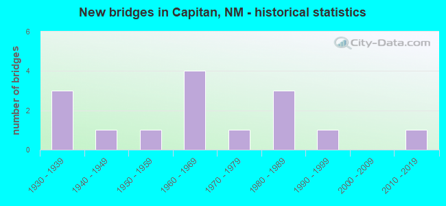
- New bridges - historical statistics
- 31930-1939
- 11940-1949
- 11950-1959
- 41960-1969
- 11970-1979
- 31980-1989
- 11990-1999
- 12010-2019

- Reconstructed bridges - Historical Statistics
- 11970-1979
- 01980-1989
- 21990-1999


- Bridge Condition - Deck
- 33.3%Good
- 33.3%Satisfactory
- 33.3%Fair

- Bridge Condition - Superstructure
- 33.3%Good
- 66.7%Satisfactory

- Bridge Condition - Substructure
- 33.3%Good
- 33.3%Satisfactory
- 33.3%Poor

- Bridge Condition - Channel
- 7.7%Excellent
- 38.5%Good
- 38.5%Satisfactory
- 15.4%Fair

- Bridge Condition - Culverts
- 16.7%Good
- 50.0%Satisfactory
- 33.3%Fair
Find on map >> Show street view
Structure Number: 31, Location: 0.01 MI E OF JCT US 64/84 (Lat: 36.754069, Lng: -106.560919), Route carried "on" structure: County highway 39334, Year Built: 1940, Status: Open, Structure Length: 0.70m (2.30ft), Average Daily Traffic: 132 (year 2020), Average Future Daily Traffic: 218 (year 2040), Design Load: H 15, Features Intersected: UNNAMED WATERWAY, Facility Carried by Structure: 39-0334
Minimum Vertical Clearance: 30+ m (98+ ft), Kilometerpoint: 0.000, Lanes on structure: 2, Owner: County Highway Agency, Approaching Roadway Width: 4.0m (13.1ft), Material/Design: Wood or Timber, Design/Construction: Stringer/Multi-beam, Number Of Spans In Main Unit: 1, Length of Maximum Span: 7.0m (23.0ft), Curb-To-Curb Width: 5.0m (16.4ft), Out-to-Out Width: 5.5m (18.0ft)
Condition: Deck: Satisfactory, Superstructure: Satisfactory, Substructure: Poor, Channel: Excellent, Operating Rating: 34.0 metric tons, Method Used To Determine Operating Rating: Allowable Stress (AS), Inventory Rating: 24.0 metric tons, Method Used To Determine Inventory Rating: Allowable Stress (AS), Structural Evaluation: Meets minimum limits, Deck Geometry: High priority of replacement, Waterway Adequacy: Meets minimum limits, Approach Roadway Alignment: Meets minimum limits, Length Of Structure Improvement: 0.70m (2.30ft), Designated Inspection Frequency: Every 12 months, Inspection Date: October 2021, Bridge Improvement Cost: $52,000, Roadway Improvement Cost: $5,000, Total Project Cost: $79,000 ( Estimate for 2030), Deck Structure Type: Wood or Timber, Wearing Surface/Protective System: Wearing Surface: Bituminous
Find on map >> Show street view
Structure Number: 306, Location: 8.7 MI E OF NM-371 (Lat: 35.372994, Lng: -108.084033), Route carried "on" structure: State highway 122, Year Built: 1936, Status: Open, Structure Length: 1.59m (5.22ft), Average Daily Traffic: 856 (year 2020), Truck Traffic: 21%, Average Future Daily Traffic: 735 (year 2040), Design Load: H 15, Features Intersected: UNNAMED WATERWAY
Minimum Vertical Clearance: 30+ m (98+ ft), Kilometerpoint: 23.775, Lanes on structure: 2, Owner: State Highway Agency, Approaching Roadway Width: 7.9m (25.9ft), Material/Design: Concrete continuous, Design/Construction: Culvert, Number Of Spans In Main Unit: 8, Length of Maximum Span: 1.8m (5.9ft)
Condition: Channel: Good, Culverts: Fair, Operating Rating: 38.9 metric tons, Method Used To Determine Operating Rating: Load Factor (LF), Inventory Rating: 24.3 metric tons, Method Used To Determine Inventory Rating: Load Factor (LF), Structural Evaluation: Somewhat better than minimum adequacy, Waterway Adequacy: Equal to present desirable criteria, Approach Roadway Alignment: Equal to present desirable criteria, Designated Inspection Frequency: Every 48 months, Inspection Date: July 2020
Find on map >> Show street view
Structure Number: 308, Location: 0.05 MI E FORD DR/ GALLUP (Lat: 35.529942, Lng: -108.726606), Route carried "on" structure: State highway 118, Year Built: 1931, Year Reconstructed: 1977, Status: Open, Structure Length: 0.95m (3.12ft), Average Daily Traffic: 18,243 (year 2020), Truck Traffic: 1%, Average Future Daily Traffic: 15,807 (year 2040), Design Load: H 15, Features Intersected: UNNAMED WATERWAY
Minimum Vertical Clearance: 30+ m (98+ ft), Kilometerpoint: 36.727, Lanes on structure: 6, Base Highway Network: Yes, Owner: State Highway Agency, Approaching Roadway Width: 20.4m (66.9ft), Material/Design: Concrete continuous, Design/Construction: Culvert, Number Of Spans In Main Unit: 3, Length of Maximum Span: 3.0m (9.8ft)
Condition: Channel: Fair, Culverts: Satisfactory, Operating Rating: 77.8 metric tons, Method Used To Determine Operating Rating: Load Factor (LF), Inventory Rating: 24.3 metric tons, Method Used To Determine Inventory Rating: Load Factor (LF), Structural Evaluation: Equal to present minimum criteria, Waterway Adequacy: Somewhat better than minimum adequacy, Approach Roadway Alignment: Equal to present desirable criteria, Designated Inspection Frequency: Every 24 months, Inspection Date: November 2021
Find on map >> Show street view
Structure Number: 3218, Location: 2.8 M E JCT NM-48/CAPITAN (Lat: 33.537794, Lng: -105.527150), Route carried "on" structure: US 380, Year Built: 1935, Status: Open, Structure Length: 0.67m (2.20ft), Average Daily Traffic: 2,296 (year 2020), Truck Traffic: 20%, Average Future Daily Traffic: 3,333 (year 2040), Design Load: H 15, Features Intersected: UNNAMED WATERWAY
Minimum Vertical Clearance: 30+ m (98+ ft), Kilometerpoint: 141.905, Lanes on structure: 2, Base Highway Network: Yes, Owner: State Highway Agency, Approaching Roadway Width: 7.6m (24.9ft), Material/Design: Concrete continuous, Design/Construction: Culvert, Number Of Spans In Main Unit: 2, Length of Maximum Span: 3.0m (9.8ft)
Condition: Channel: Fair, Culverts: Fair, Operating Rating: 59.9 metric tons, Method Used To Determine Operating Rating: Load Factor (LF), Inventory Rating: 24.3 metric tons, Method Used To Determine Inventory Rating: Load Factor (LF), Structural Evaluation: Somewhat better than minimum adequacy, Waterway Adequacy: Better than present minimum criteria, Approach Roadway Alignment: Better than present minimum criteria, Length Of Structure Improvement: 0.70m (2.30ft), Designated Inspection Frequency: Every 24 months, Inspection Date: Febuary 2021, Bridge Improvement Cost: $43,000, Roadway Improvement Cost: $4,000, Total Project Cost: $64,000 ( Estimate for 2020)
Find on map >> Show street view
Structure Number: 5608, Location: 10.5 M N JCT US62/CARLSBD (Lat: 32.494461, Lng: -104.360664), Route carried "on" structure: US 285, Year Built: 1952, Year Reconstructed: 1999, Status: Open, Structure Length: 1.71m (5.61ft), Average Daily Traffic: 11,738 (year 2020), Truck Traffic: 30%, Average Future Daily Traffic: 4,640 (year 2040), Design Load: HS 20, Features Intersected: SPENCER DRAW
Minimum Vertical Clearance: 30+ m (98+ ft), Kilometerpoint: 70.327, Lanes on structure: 4, Base Highway Network: Yes, Owner: State Highway Agency, Approaching Roadway Width: 24.2m (79.4ft), Skew: 20 degrees, Material/Design: Concrete continuous, Design/Construction: Culvert, Number Of Spans In Main Unit: 5, Length of Maximum Span: 3.0m (9.8ft)
Condition: Channel: Good, Culverts: Satisfactory, Operating Rating: 89.1 metric tons, Method Used To Determine Operating Rating: Load Factor (LF), Inventory Rating: 32.4 metric tons, Method Used To Determine Inventory Rating: Load Factor (LF), Structural Evaluation: Equal to present minimum criteria, Waterway Adequacy: Equal to present desirable criteria, Approach Roadway Alignment: Equal to present desirable criteria, Length Of Structure Improvement: 1.71m (5.61ft), Designated Inspection Frequency: Every 48 months, Inspection Date: May 2018, Bridge Improvement Cost: $192,000, Roadway Improvement Cost: $19,000, Total Project Cost: $288,000 ( Estimate for 2030)
Find on map >> Show street view
Structure Number: 67, Location: 2.9 MI N OF JCT I-25/I-40 (Lat: 35.135961, Lng: -106.605122), Route carried "on" structure: State highway 2537, Year Built: 1966, Status: Open, Structure Length: 5.15m (16.90ft), Average Daily Traffic: 10,054 (year 2020), Truck Traffic: 6%, Average Future Daily Traffic: 8,364 (year 2040), Design Load: HS 20, Features Intersected: N DIVERSON CHANNEL
Minimum Vertical Clearance: 30+ m (98+ ft), Kilometerpoint: 368.266, Lanes on structure: 2, Owner: State Highway Agency, Approaching Roadway Width: 6.2m (20.3ft), Skew: 3 degrees, Material/Design: Prestressed concrete, Design/Construction: Stringer/Multi-beam, Number Of Spans In Main Unit: 2, Length of Maximum Span: 24.7m (81.0ft), Curb-To-Curb Width: 8.1m (26.6ft), Out-to-Out Width: 10.4m (34.1ft)
Condition: Deck: Fair, Superstructure: Satisfactory, Substructure: Satisfactory, Channel: Satisfactory, Operating Rating: 50.9 metric tons, Method Used To Determine Operating Rating: Load Factor (LF), Inventory Rating: 31.0 metric tons, Method Used To Determine Inventory Rating: Load Factor (LF), Structural Evaluation: Equal to present minimum criteria, Deck Geometry: High priority of replacement, Waterway Adequacy: Superior to present desirable criteria, Approach Roadway Alignment: Equal to present desirable criteria, Designated Inspection Frequency: Every 24 months, Inspection Date: September 2021, Deck Structure Type: Concrete Cast-file-Place
Find on map >> Show street view
Structure Number: 671, Location: 7.4 MI E OF US-491 (Lat: 35.531211, Lng: -108.630944), Route carried "on" structure: Interstate 40, Year Built: 1965, Status: Open, Structure Length: 0.77m (2.53ft), Average Daily Traffic: 20,921 (year 2020), Truck Traffic: 37%, Average Future Daily Traffic: 35,816 (year 2040), Design Load: HS 20, Features Intersected: SUNDANCE ROAD
Minimum Vertical Clearance: 30+ m (98+ ft), Kilometerpoint: 45.540, Lanes on structure: 4, Lanes under structure: 2, Base Highway Network: Yes, Owner: State Highway Agency, Approaching Roadway Width: 24.1m (79.1ft), Skew: 20 degrees, Material/Design: Concrete, Design/Construction: Culvert, Number Of Spans In Main Unit: 1, Length of Maximum Span: 7.7m (25.3ft), Curb or Sidewalk Widths: Left: 0.5m (1.6ft), Right: 0.5m (1.6ft)
Condition: Culverts: Fair, Operating Rating: 66.4 metric tons, Method Used To Determine Operating Rating: Load Factor (LF), Inventory Rating: 32.4 metric tons, Method Used To Determine Inventory Rating: Load Factor (LF), Structural Evaluation: Somewhat better than minimum adequacy, Underclear: High priority of corrective action, Approach Roadway Alignment: Equal to present desirable criteria, Length Of Structure Improvement: 0.85m (2.79ft), Designated Inspection Frequency: Every 24 months, Inspection Date: September 2020, Bridge Improvement Cost: $200,000, Roadway Improvement Cost: $20,000, Total Project Cost: $300,000 ( Estimate for 2020)
Find on map >> Show street view
Structure Number: 672, Location: 0.12 M S OF JCT NM197 (Lat: 36.010150, Lng: -106.969869), Route carried "on" structure: US 550, Year Built: 1965, Year Reconstructed: 2001, Status: Open, Structure Length: 2.61m (8.56ft), Average Daily Traffic: 4,445 (year 2020), Truck Traffic: 16%, Average Future Daily Traffic: 3,431 (year 2040), Design Load: HS 20, Features Intersected: NACIMIENTO CREEK
Minimum Vertical Clearance: 30+ m (98+ ft), Kilometerpoint: 101.614, Lanes on structure: 4, Base Highway Network: Yes, Owner: State Highway Agency, Approaching Roadway Width: 25.6m (84.0ft), Skew: 24 degrees, Material/Design: Concrete continuous, Design/Construction: Culvert, Number Of Spans In Main Unit: 7, Length of Maximum Span: 2.4m (7.9ft)
Condition: Channel: Satisfactory, Culverts: Good, Operating Rating: 37.3 metric tons, Method Used To Determine Operating Rating: Load Factor (LF), Inventory Rating: 32.4 metric tons, Method Used To Determine Inventory Rating: Load Factor (LF), Structural Evaluation: Better than present minimum criteria, Waterway Adequacy: Equal to present desirable criteria, Approach Roadway Alignment: Equal to present desirable criteria, Length Of Structure Improvement: 1.52m (4.99ft), Designated Inspection Frequency: Every 48 months, Inspection Date: September 2021, Bridge Improvement Cost: $183,000, Roadway Improvement Cost: $18,000, Total Project Cost: $275,000 ( Estimate for 2020)
Find on map >> Show street view
Structure Number: 673, Location: 19.9 MI E OF ARIZ ST LINE (Lat: 35.522719, Lng: -108.779472), Route carried "on" structure: Interstate 40, Year Built: 1966, Status: Open, Structure Length: 1.01m (3.31ft), Average Daily Traffic: 19,032 (year 2020), Truck Traffic: 37%, Average Future Daily Traffic: 32,581 (year 2040), Design Load: HS 20, Features Intersected: ALLISON RD
Minimum Vertical Clearance: 30+ m (98+ ft), Kilometerpoint: 31.592, Lanes on structure: 4, Lanes under structure: 2, Base Highway Network: Yes, Owner: State Highway Agency, Approaching Roadway Width: 23.8m (78.1ft), Skew: 14 degrees, Material/Design: Concrete, Design/Construction: Culvert, Number Of Spans In Main Unit: 1, Length of Maximum Span: 7.6m (24.9ft), Curb or Sidewalk Widths: Left: 0.5m (1.6ft), Right: 0.5m (1.6ft), Curb-To-Curb Width: 23.8m (78.1ft), Out-to-Out Width: 23.8m (78.1ft)
Condition: Culverts: Fair, Operating Rating: 66.4 metric tons, Method Used To Determine Operating Rating: Load Factor (LF), Inventory Rating: 32.4 metric tons, Method Used To Determine Inventory Rating: Load Factor (LF), Structural Evaluation: Somewhat better than minimum adequacy, Deck Geometry: Superior to present desirable criteria, Underclear: High priority of corrective action, Approach Roadway Alignment: Equal to present desirable criteria, Length Of Structure Improvement: 1.16m (3.81ft), Designated Inspection Frequency: Every 24 months, Inspection Date: January 2022, Bridge Improvement Cost: $298,000, Roadway Improvement Cost: $30,000, Total Project Cost: $447,000 ( Estimate for 2020)
Find on map >> Show street view
Structure Number: 7633, Location: 2.05 MI NE OF JCT US-180 (Lat: 32.776233, Lng: -108.120822), Route carried "on" structure: State highway 356, Year Built: 1974, Status: Open, Structure Length: 0.86m (2.82ft), Average Daily Traffic: 2,085 (year 2020), Truck Traffic: 21%, Average Future Daily Traffic: 1,792 (year 2040), Design Load: H 15, Features Intersected: UNNAMED WATERWAY
Minimum Vertical Clearance: 30+ m (98+ ft), Kilometerpoint: 3.058, Lanes on structure: 2, Owner: State Highway Agency, Approaching Roadway Width: 13.9m (45.6ft), Skew: 4 degrees, Material/Design: Steel, Design/Construction: Culvert, Number Of Spans In Main Unit: 1, Length of Maximum Span: 8.6m (28.2ft)
Condition: Channel: Good, Culverts: Satisfactory, Operating Rating: 76.7 metric tons, Method Used To Determine Operating Rating: Load Factor (LF), Inventory Rating: 32.7 metric tons, Method Used To Determine Inventory Rating: Load Factor (LF), Structural Evaluation: Equal to present minimum criteria, Waterway Adequacy: Equal to present desirable criteria, Approach Roadway Alignment: Equal to present desirable criteria, Designated Inspection Frequency: Every 24 months, Inspection Date: April 2021
Find on map >> Show street view
Structure Number: 8328, Location: 1.7 MI W OF NM-48/CAPITAN (Lat: 33.554661, Lng: -105.600164), Route carried "on" structure: US 380, Year Built: 1980, Status: Open, Structure Length: 0.70m (2.30ft), Average Daily Traffic: 557 (year 2020), Truck Traffic: 20%, Average Future Daily Traffic: 808 (year 2040), Design Load: HS 20, Features Intersected: SALADO CREEK
Minimum Vertical Clearance: 30+ m (98+ ft), Kilometerpoint: 134.216, Lanes on structure: 2, Base Highway Network: Yes, Owner: State Highway Agency, Approaching Roadway Width: 14.3m (46.9ft), Skew: 6 degrees, Material/Design: Steel, Design/Construction: Culvert, Number Of Spans In Main Unit: 1, Length of Maximum Span: 6.4m (21.0ft)
Condition: Channel: Satisfactory, Culverts: Satisfactory, Operating Rating: 64.8 metric tons, Method Used To Determine Operating Rating: Load Factor (LF), Inventory Rating: 40.5 metric tons, Method Used To Determine Inventory Rating: Load Factor (LF), Structural Evaluation: Equal to present minimum criteria, Waterway Adequacy: Equal to present minimum criteria, Approach Roadway Alignment: Equal to present desirable criteria, Length Of Structure Improvement: 0.70m (2.30ft), Designated Inspection Frequency: Every 48 months, Inspection Date: July 2018, Bridge Improvement Cost: $298,000, Roadway Improvement Cost: $29,000, Total Project Cost: $447,000 ( Estimate for 2020)
Find on map >> Show street view
Structure Number: 8469, Location: 0.47 M E OF NM-48/CAPTIAN (Lat: 33.544792, Lng: -105.564969), Route carried "on" structure: US 380, Year Built: 1983, Status: Open, Structure Length: 1.04m (3.41ft), Average Daily Traffic: 2,296 (year 2020), Truck Traffic: 20%, Average Future Daily Traffic: 3,333 (year 2040), Design Load: HS 20, Features Intersected: MAGADO CREEK
Minimum Vertical Clearance: 30+ m (98+ ft), Kilometerpoint: 137.732, Lanes on structure: 2, Base Highway Network: Yes, Owner: State Highway Agency, Approaching Roadway Width: 12.2m (40.0ft), Material/Design: Steel, Design/Construction: Culvert, Number Of Spans In Main Unit: 1, Length of Maximum Span: 10.4m (34.1ft)
Condition: Channel: Satisfactory, Culverts: Satisfactory, Operating Rating: 56.7 metric tons, Method Used To Determine Operating Rating: Load Factor (LF), Inventory Rating: 32.4 metric tons, Method Used To Determine Inventory Rating: Load Factor (LF), Structural Evaluation: Equal to present minimum criteria, Waterway Adequacy: Equal to present minimum criteria, Approach Roadway Alignment: Equal to present desirable criteria, Length Of Structure Improvement: 1.04m (3.41ft), Designated Inspection Frequency: Every 24 months, Inspection Date: August 2020, Bridge Improvement Cost: $252,000, Roadway Improvement Cost: $25,000, Total Project Cost: $379,000 ( Estimate for 2020)
Find on map >> Show street view
Structure Number: 8711, Location: 400' N OF US-380/CAPITAN (Lat: 33.546597, Lng: -105.572894), Route carried "on" structure: State highway 246, Year Built: 1987, Status: Open, Structure Length: 0.82m (2.69ft), Average Daily Traffic: 324 (year 2020), Truck Traffic: 16%, Average Future Daily Traffic: 606 (year 2040), Design Load: HS 20, Features Intersected: SALADO CREEK
Minimum Vertical Clearance: 30+ m (98+ ft), Kilometerpoint: 0.126, Lanes on structure: 2, Owner: State Highway Agency, Approaching Roadway Width: 9.8m (32.2ft), Material/Design: Steel, Design/Construction: Culvert, Number Of Spans In Main Unit: 1, Length of Maximum Span: 8.2m (26.9ft)
Condition: Channel: Satisfactory, Culverts: Satisfactory, Operating Rating: 71.3 metric tons, Method Used To Determine Operating Rating: Load Factor (LF), Inventory Rating: 32.4 metric tons, Method Used To Determine Inventory Rating: Load Factor (LF), Structural Evaluation: Equal to present minimum criteria, Waterway Adequacy: Equal to present minimum criteria, Approach Roadway Alignment: Equal to present desirable criteria, Designated Inspection Frequency: Every 24 months, Inspection Date: March 2021
Find on map >> Show street view
Structure Number: 9486, Location: 10.9 Mi E of NM-48 (Lat: 33.504928, Lng: -105.405242), Route carried "on" structure: US 380, Year Built: 2011, Status: Open, Structure Length: 2.87m (9.42ft), Average Daily Traffic: 822 (year 2020), Truck Traffic: 20%, Average Future Daily Traffic: 1,194 (year 2040), Design Load: HS 20, Features Intersected: Priest Gulch
Minimum Vertical Clearance: 30.45m (99.90ft), Kilometerpoint: 154.941, Lanes on structure: 2, Base Highway Network: Yes, Owner: State Highway Agency, Approaching Roadway Width: 9.4m (30.8ft), Skew: 2 degrees, Material/Design: Prestressed concrete, Design/Construction: Stringer/Multi-beam, Number Of Spans In Main Unit: 1, Length of Maximum Span: 27.7m (90.9ft), Curb or Sidewalk Widths: Left: 0.0m, Right: 1.8m (5.9ft), Curb-To-Curb Width: 10.1m (33.1ft), Out-to-Out Width: 12.6m (41.3ft)
Condition: Deck: Good, Superstructure: Good, Substructure: Good, Channel: Good, Operating Rating: 66.0 metric tons, Method Used To Determine Operating Rating: Load Factor (LF), Inventory Rating: 22.9 metric tons, Method Used To Determine Inventory Rating: Load Factor (LF), Structural Evaluation: Equal to present minimum criteria, Deck Geometry: Equal to present minimum criteria, Waterway Adequacy: Equal to present desirable criteria, Approach Roadway Alignment: Equal to present desirable criteria, Length Of Structure Improvement: 6.10m (20.01ft), Designated Inspection Frequency: Every 24 months, Inspection Date: March 2021, Bridge Improvement Cost: $250,000, Roadway Improvement Cost: $150,000, Total Project Cost: $500,000 ( Estimate for 2070), Deck Structure Type: Concrete Cast-file-Place, Wearing Surface/Protective System: Deck Protection: Epoxy Coated Reinforcing
Find on map >> Show street view
Structure Number: 10001, Location: 0.27 Mi W of Coors Rd SW (Lat: 35.059322, Lng: -106.712483), Route carried "on" structure: City street 5065, Year Built: 1990, Status: Open, Structure Length: 1.14m (3.74ft), Average Daily Traffic: 4,753 (year 2020), Truck Traffic: 7%, Average Future Daily Traffic: 7,746 (year 2040), Design Load: HS 20, Features Intersected: Amole Del Norte Channel, Facility Carried by Structure: Sage SW
Minimum Vertical Clearance: 30+ m (98+ ft), Kilometerpoint: 0.000, Lanes on structure: 2, Owner: City or Municipal Highway Agency, Approaching Roadway Width: 8.0m (26.2ft), Skew: 3 degrees, Material/Design: Concrete, Design/Construction: Culvert, Number Of Spans In Main Unit: 1, Length of Maximum Span: 9.1m (29.9ft)
Condition: Channel: Good, Culverts: Good, Operating Rating: 43.7 metric tons, Method Used To Determine Operating Rating: Load Factor (LF), Inventory Rating: 32.4 metric tons, Method Used To Determine Inventory Rating: Load Factor (LF), Structural Evaluation: Better than present minimum criteria, Waterway Adequacy: Equal to present desirable criteria, Approach Roadway Alignment: Equal to present desirable criteria, Designated Inspection Frequency: Every 24 months, Inspection Date: Febuary 2022