Bridge Statistics for Capron, Illinois (IL)
Condition, Traffic, Stress, Structural Evaluation, Project Costs
- National Bridge Inventory (NBI) Statistics
- 15Number of bridges
- 98ft / 30.0mTotal length
- 19,635Total average daily traffic
- 2,177Total average daily truck traffic
- 20,629Total future (year 2032) average daily traffic
- National Bridge Inventory (NBI) Registered Bridges for Capron
- No street view available for this location
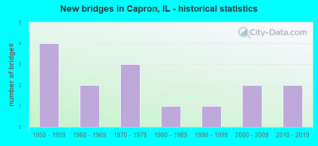
- New bridges - historical statistics
- 41950-1959
- 21960-1969
- 31970-1979
- 11980-1989
- 11990-1999
- 22000-2009
- 22010-2019


- Bridge Condition - Deck
- 25.0%Very good
- 12.5%Good
- 37.5%Satisfactory
- 12.5%Fair
- 12.5%Poor

- Bridge Condition - Superstructure
- 12.5%Very good
- 25.0%Good
- 37.5%Satisfactory
- 12.5%Poor
- 12.5%Serious

- Bridge Condition - Substructure
- 25.0%Very good
- 25.0%Good
- 12.5%Satisfactory
- 37.5%Poor

- Bridge Condition - Channel
- 33.3%Very good
- 20.0%Good
- 26.7%Satisfactory
- 13.3%Fair
- 6.7%Poor

- Bridge Condition - Culverts
- 14.3%Very good
- 71.4%Good
- 14.3%Satisfactory
Find on map >> Show street view
Structure Number: 40018, Location: AT MCHENRY CO. LN. (Lat: 42.400689, Lng: -88.706222), Route carried "on" structure: State highway 173, Year Built: 2001, Status: Open, Structure Length: 2.74m (8.99ft), Average Daily Traffic: 5,200 (year 2021), Truck Traffic: 13%, Average Future Daily Traffic: 5,200 (year 2040), Design Load: HS 20, Features Intersected: PISCASAW CREEKTRIB.
Minimum Vertical Clearance: 30+ m (98+ ft), Kilometerpoint: 28.629, Lanes on structure: 2, Base Highway Network: Yes, Owner: State Highway Agency, Approaching Roadway Width: 7.6m (24.9ft), Material/Design: Concrete continuous, Design/Construction: Slab, Number Of Spans In Main Unit: 3, Length of Maximum Span: 10.7m (35.1ft), Curb-To-Curb Width: 10.8m (35.4ft), Out-to-Out Width: 11.8m (38.7ft)
Condition: Deck: Good, Superstructure: Good, Substructure: Good, Channel: Satisfactory, Operating Rating: 75.5 metric tons, Method Used To Determine Operating Rating: Load Factor (LF) rating reported by rating factor (RF) method using MS18 loading, Inventory Rating: 45.4 metric tons, Method Used To Determine Inventory Rating: Load Factor (LF) rating reported by rating factor (RF) method using MS18 loading, Structural Evaluation: Better than present minimum criteria, Deck Geometry: Meets minimum limits, Waterway Adequacy: Equal to present desirable criteria, Approach Roadway Alignment: Equal to present desirable criteria, Designated Inspection Frequency: Every 48 months, Inspection Date: April 2018, Deck Structure Type: Concrete Cast-file-Place, Wearing Surface/Protective System: Deck Protection: Epoxy Coated Reinforcing
Find on map >> Show street view
Structure Number: 42002, Location: 1.5 MI W CAPRON (Lat: 42.381706, Lng: -88.768983), Route carried "on" structure: State highway 173, Year Built: 1974, Status: Open, Structure Length: 0.98m (3.22ft), Average Daily Traffic: 4,850 (year 2021), Truck Traffic: 12%, Average Future Daily Traffic: 5,500 (year 2040), Design Load: HS 20, Features Intersected: BEAVER CR TRIBUTARY
Minimum Vertical Clearance: 30+ m (98+ ft), Kilometerpoint: 22.466, Lanes on structure: 2, Base Highway Network: Yes, Owner: State Highway Agency, Approaching Roadway Width: 7.6m (24.9ft), Material/Design: Concrete, Design/Construction: Culvert, Number Of Spans In Main Unit: 3, Length of Maximum Span: 3.6m (11.8ft), Curb-To-Curb Width: 12.2m (40.0ft), Out-to-Out Width: 12.2m (40.0ft)
Condition: Channel: Satisfactory, Culverts: Satisfactory, Operating Rating: 52.2 metric tons, Method Used To Determine Operating Rating: Load Factor (LF) rating reported by rating factor (RF) method using MS18 loading, Inventory Rating: 31.1 metric tons, Method Used To Determine Inventory Rating: Load Factor (LF) rating reported by rating factor (RF) method using MS18 loading, Structural Evaluation: Equal to present minimum criteria, Deck Geometry: Equal to present minimum criteria, Waterway Adequacy: Equal to present desirable criteria, Approach Roadway Alignment: Equal to present desirable criteria, Designated Inspection Frequency: Every 24 months, Inspection Date: July 2021, Deck Structure Type: Concrete Cast-file-Place, Wearing Surface/Protective System: Wearing Surface: Bituminous, Membrane: Built-up
Find on map >> Show street view
Structure Number: 42004, Location: 0.5 MI. SW. CAPRON (Lat: 42.389939, Lng: -88.754947), Route carried "on" structure: State highway 173, Year Built: 1994, Status: Open, Structure Length: 0.79m (2.59ft), Average Daily Traffic: 4,850 (year 2021), Truck Traffic: 12%, Average Future Daily Traffic: 4,900 (year 2040), Design Load: HS 20+Mod, Features Intersected: BEAVER CREEK
Minimum Vertical Clearance: 30+ m (98+ ft), Kilometerpoint: 23.946, Lanes on structure: 2, Base Highway Network: Yes, Owner: State Highway Agency, Approaching Roadway Width: 7.9m (25.9ft), Material/Design: Concrete, Design/Construction: Culvert, Number Of Spans In Main Unit: 3, Length of Maximum Span: 2.6m (8.5ft), Curb-To-Curb Width: 12.2m (40.0ft), Out-to-Out Width: 14.0m (45.9ft)
Condition: Channel: Poor, Culverts: Good, Operating Rating: 55.1 metric tons, Method Used To Determine Operating Rating: Load Factor (LF) rating reported by rating factor (RF) method using MS18 loading, Inventory Rating: 33.0 metric tons, Method Used To Determine Inventory Rating: Load Factor (LF) rating reported by rating factor (RF) method using MS18 loading, Structural Evaluation: Better than present minimum criteria, Deck Geometry: Equal to present minimum criteria, Waterway Adequacy: Equal to present desirable criteria, Approach Roadway Alignment: Equal to present desirable criteria, Designated Inspection Frequency: Every 48 months, Inspection Date: Febuary 2019
Find on map >> Show street view
Structure Number: 43006, Location: 2.5 MI S CAPRON (Lat: 42.356406, Lng: -88.744600), Route carried "on" structure: County highway , Year Built: 1958, Status: Posted for load, Structure Length: 3.81m (12.50ft), Average Daily Traffic: 175 (year 2018), Truck Traffic: 5%, Average Future Daily Traffic: 200 (year 2040), Design Load: HS 15, Features Intersected: PISCASAW CREEK, Facility Carried by Structure: CAPRON RD
Minimum Vertical Clearance: 30+ m (98+ ft), Kilometerpoint: 4.796, Lanes on structure: 2, Owner: County Highway Agency, Approaching Roadway Width: 10.4m (34.1ft), Material/Design: Concrete, Design/Construction: Slab, Number Of Spans In Main Unit: 4, Length of Maximum Span: 10.4m (34.1ft), Curb-To-Curb Width: 7.3m (24.0ft), Out-to-Out Width: 8.1m (26.6ft)
Condition: Deck: Satisfactory, Superstructure: Satisfactory, Substructure: Poor, Channel: Good, Operating Rating: 38.6 metric tons, Method Used To Determine Operating Rating: Load Factor (LF) rating reported by rating factor (RF) method using MS18 loading, Inventory Rating: 17.2 metric tons, Method Used To Determine Inventory Rating: Load Factor (LF) rating reported by rating factor (RF) method using MS18 loading, Structural Evaluation: Meets minimum limits, Deck Geometry: Somewhat better than minimum adequacy, Waterway Adequacy: Equal to present desirable criteria, Approach Roadway Alignment: Equal to present desirable criteria, Bridge Posting: Required (Relationship of Operating Rating to Maximum Legal Load: 30.0 - 39.9% below), Designated Inspection Frequency: Every 24 months, Other Special Inspection Frequency: Every 12 months, Inspection Date: March 2021, Other Special Inspection Date: March 2021, Deck Structure Type: Concrete Cast-file-Place, Wearing Surface/Protective System: Wearing Surface: Bituminous
Find on map >> Show street view
Structure Number: 43015, Location: 1.5 E CAPRON (Lat: 42.404919, Lng: -88.705861), Route carried "on" structure: County highway , Year Built: 1968, Status: Open, Structure Length: 0.79m (2.59ft), Average Daily Traffic: 225 (year 2021), Truck Traffic: 11%, Average Future Daily Traffic: 300 (year 2040), Design Load: HS 15, Features Intersected: BR PISCASAW CREEK, Facility Carried by Structure: COUNTY LINE RD
Minimum Vertical Clearance: 30+ m (98+ ft), Kilometerpoint: 2.752, Lanes on structure: 2, Owner: Town or Township Highway Agency, Approaching Roadway Width: 9.1m (29.9ft), Skew: 3 degrees, Material/Design: Steel, Design/Construction: Culvert, Number Of Spans In Main Unit: 3, Length of Maximum Span: 2.5m (8.2ft)
Condition: Channel: Very good, Culverts: Good, Operating Rating: 88.8 metric tons, Method Used To Determine Operating Rating: Load Factor (LF) rating reported by rating factor (RF) method using MS18 loading, Inventory Rating: 88.8 metric tons, Method Used To Determine Inventory Rating: Load Factor (LF) rating reported by rating factor (RF) method using MS18 loading, Structural Evaluation: Better than present minimum criteria, Waterway Adequacy: Better than present minimum criteria, Approach Roadway Alignment: Equal to present desirable criteria, Designated Inspection Frequency: Every 24 months, Inspection Date: March 2020
Find on map >> Show street view
Structure Number: 43017, Location: 2.5 MI SE OF CAPRON (Lat: 42.372319, Lng: -88.705714), Route carried "on" structure: County highway , Year Built: 1959, Status: Posted for load, Structure Length: 3.81m (12.50ft), Average Daily Traffic: 475 (year 2021), Truck Traffic: 10%, Average Future Daily Traffic: 600 (year 2040), Design Load: HS 15, Features Intersected: PISCASAW CREEK, Facility Carried by Structure: COUNTY LINE RD
Minimum Vertical Clearance: 30+ m (98+ ft), Kilometerpoint: 6.325, Lanes on structure: 2, Owner: Town or Township Highway Agency, Approaching Roadway Width: 9.1m (29.9ft), Material/Design: Concrete continuous, Design/Construction: Slab, Number Of Spans In Main Unit: 4, Length of Maximum Span: 10.4m (34.1ft), Curb-To-Curb Width: 7.4m (24.3ft), Out-to-Out Width: 8.0m (26.2ft)
Condition: Deck: Fair, Superstructure: Satisfactory, Substructure: Satisfactory, Channel: Fair, Operating Rating: 28.2 metric tons, Method Used To Determine Operating Rating: Load Factor (LF) rating reported by rating factor (RF) method using MS18 loading, Inventory Rating: 16.8 metric tons, Method Used To Determine Inventory Rating: Load Factor (LF) rating reported by rating factor (RF) method using MS18 loading, Structural Evaluation: Somewhat better than minimum adequacy, Deck Geometry: Meets minimum limits, Waterway Adequacy: Equal to present minimum criteria, Approach Roadway Alignment: Better than present minimum criteria, Bridge Posting: Required (Relationship of Operating Rating to Maximum Legal Load: 0.1 - 9.9% below), Designated Inspection Frequency: Every 24 months, Inspection Date: March 2020, Deck Structure Type: Concrete Cast-file-Place
Find on map >> Show street view
Structure Number: 43051, Location: 3.0 MI NW CAPRON (Lat: 42.442025, Lng: -88.764539), Route carried "on" structure: County highway , Year Built: 1968, Status: Open, Structure Length: 0.79m (2.59ft), Average Daily Traffic: 10 (year 2018), Truck Traffic: 20%, Average Future Daily Traffic: 25 (year 2040), Design Load: HS 20, Features Intersected: BEAVER CREEK, Facility Carried by Structure: LEROY CENTER RD
Minimum Vertical Clearance: 30+ m (98+ ft), Kilometerpoint: 5.536, Lanes on structure: 2, Owner: Town or Township Highway Agency, Approaching Roadway Width: 9.1m (29.9ft), Skew: 4 degrees, Material/Design: Steel, Design/Construction: Culvert, Number Of Spans In Main Unit: 3, Length of Maximum Span: 1.8m (5.9ft)
Condition: Channel: Good, Culverts: Good, Operating Rating: 88.8 metric tons, Method Used To Determine Operating Rating: Load Factor (LF) rating reported by rating factor (RF) method using MS18 loading, Inventory Rating: 88.8 metric tons, Method Used To Determine Inventory Rating: Load Factor (LF) rating reported by rating factor (RF) method using MS18 loading, Structural Evaluation: Better than present minimum criteria, Waterway Adequacy: Better than present minimum criteria, Approach Roadway Alignment: Better than present minimum criteria, Designated Inspection Frequency: Every 24 months, Inspection Date: July 2021
Find on map >> Show street view
Structure Number: 4306, Location: 3.0 MI N CAPRON (Lat: 42.441758, Lng: -88.753453), Route carried "on" structure: County highway , Year Built: 1972, Status: Open, Structure Length: 1.01m (3.31ft), Average Daily Traffic: 50 (year 2018), Truck Traffic: 4%, Average Future Daily Traffic: 110 (year 2040), Design Load: HS 20, Features Intersected: BRANCH BEAVER CREEK, Facility Carried by Structure: BLAINE RD
Minimum Vertical Clearance: 30+ m (98+ ft), Kilometerpoint: 0.917, Lanes on structure: 2, Owner: Town or Township Highway Agency, Approaching Roadway Width: 9.1m (29.9ft), Material/Design: Steel, Design/Construction: Culvert, Number Of Spans In Main Unit: 4, Length of Maximum Span: 2.0m (6.6ft)
Condition: Channel: Good, Culverts: Good, Operating Rating: 88.8 metric tons, Method Used To Determine Operating Rating: Load Factor (LF) rating reported by rating factor (RF) method using MS18 loading, Inventory Rating: 88.8 metric tons, Method Used To Determine Inventory Rating: Load Factor (LF) rating reported by rating factor (RF) method using MS18 loading, Structural Evaluation: Better than present minimum criteria, Waterway Adequacy: Equal to present minimum criteria, Approach Roadway Alignment: Equal to present desirable criteria, Designated Inspection Frequency: Every 24 months, Inspection Date: July 2021
Find on map >> Show street view
Structure Number: 43066, Location: 1.5 MI S OF CAPRON (Lat: 42.373544, Lng: -88.725219), Route carried "on" structure: County highway , Year Built: 1975, Status: Open, Structure Length: 3.72m (12.20ft), Average Daily Traffic: 150 (year 2018), Truck Traffic: 1%, Average Future Daily Traffic: 125 (year 2040), Design Load: HS 15, Features Intersected: PISCASAW CREEK, Facility Carried by Structure: MILL RD
Minimum Vertical Clearance: 30+ m (98+ ft), Kilometerpoint: 2.189, Lanes on structure: 2, Owner: Town or Township Highway Agency, Approaching Roadway Width: 9.1m (29.9ft), Material/Design: Concrete, Design/Construction: Channel Beam, Number Of Spans In Main Unit: 4, Length of Maximum Span: 9.1m (29.9ft), Curb-To-Curb Width: 7.3m (24.0ft), Out-to-Out Width: 8.0m (26.2ft)
Condition: Deck: Satisfactory, Superstructure: Serious, Substructure: Poor, Channel: Satisfactory, Operating Rating: 55.7 metric tons, Method Used To Determine Operating Rating: Load Factor (LF) rating reported by rating factor (RF) method using MS18 loading, Inventory Rating: 33.4 metric tons, Method Used To Determine Inventory Rating: Load Factor (LF) rating reported by rating factor (RF) method using MS18 loading, Structural Evaluation: High priority of corrective action, Deck Geometry: Somewhat better than minimum adequacy, Waterway Adequacy: Better than present minimum criteria, Approach Roadway Alignment: Better than present minimum criteria, Designated Inspection Frequency: Every 24 months, Other Special Inspection Frequency: Every 12 months, Inspection Date: September 2020, Other Special Inspection Date: July 2021, Deck Structure Type: Concrete Precast Panels
Find on map >> Show street view
Structure Number: 43073, Location: 3.5 MI S CAPRON (Lat: 42.341608, Lng: -88.734961), Route carried "on" structure: County highway , Year Built: 1981, Status: Open, Structure Length: 1.47m (4.82ft), Average Daily Traffic: 125 (year 2018), Truck Traffic: 3%, Average Future Daily Traffic: 200 (year 2040), Design Load: HS 20, Features Intersected: BR PISCASAW CREEK, Facility Carried by Structure: CAPRON RD
Minimum Vertical Clearance: 30+ m (98+ ft), Kilometerpoint: 1.867, Lanes on structure: 2, Owner: Town or Township Highway Agency, Approaching Roadway Width: 9.1m (29.9ft), Material/Design: Prestressed concrete, Design/Construction: Box Beam or Girders - Multiple, Number Of Spans In Main Unit: 1, Length of Maximum Span: 14.3m (46.9ft), Curb-To-Curb Width: 8.2m (26.9ft), Out-to-Out Width: 8.2m (26.9ft)
Condition: Deck: Satisfactory, Superstructure: Satisfactory, Substructure: Good, Channel: Very good, Operating Rating: 44.4 metric tons, Method Used To Determine Operating Rating: Assigned rating based on Load Factor Design (LFD) reported by rating factor (RF) using MS18 loading, Inventory Rating: 32.4 metric tons, Method Used To Determine Inventory Rating: Assigned rating based on Load Factor Design (LFD) reported by rating factor (RF) using MS18 loading, Structural Evaluation: Equal to present minimum criteria, Deck Geometry: Somewhat better than minimum adequacy, Waterway Adequacy: Better than present minimum criteria, Approach Roadway Alignment: Equal to present desirable criteria, Designated Inspection Frequency: Every 24 months, Inspection Date: March 2020, Deck Structure Type: Concrete Precast Panels, Wearing Surface/Protective System: Wearing Surface: Bituminous
Find on map >> Show street view
Structure Number: 43089, Location: 1.5 MI E OF CAPRON (Lat: 42.395158, Lng: -88.705767), Route carried "on" structure: County highway , Year Built: 2004, Status: Open, Structure Length: 1.83m (6.00ft), Average Daily Traffic: 600 (year 2021), Truck Traffic: 8%, Average Future Daily Traffic: 550 (year 2040), Design Load: HS 20, Features Intersected: BR PISCASAW CREEK, Facility Carried by Structure: COUNTY LINE RD
Minimum Vertical Clearance: 30+ m (98+ ft), Kilometerpoint: 3.830, Lanes on structure: 2, Owner: Town or Township Highway Agency, Approaching Roadway Width: 8.5m (27.9ft), Skew: 2 degrees, Material/Design: Prestressed concrete, Design/Construction: Box Beam or Girders - Multiple, Number Of Spans In Main Unit: 1, Length of Maximum Span: 17.5m (57.4ft), Curb-To-Curb Width: 8.5m (27.9ft), Out-to-Out Width: 8.5m (27.9ft)
Condition: Deck: Very good, Superstructure: Good, Substructure: Very good, Channel: Very good, Operating Rating: 44.1 metric tons, Method Used To Determine Operating Rating: Assigned rating based on Load Factor Design (LFD) reported by rating factor (RF) using MS18 loading, Inventory Rating: 32.4 metric tons, Method Used To Determine Inventory Rating: Assigned rating based on Load Factor Design (LFD) reported by rating factor (RF) using MS18 loading, Structural Evaluation: Better than present minimum criteria, Deck Geometry: Somewhat better than minimum adequacy, Waterway Adequacy: Equal to present desirable criteria, Approach Roadway Alignment: Equal to present desirable criteria, Designated Inspection Frequency: Every 48 months, Inspection Date: March 2020, Deck Structure Type: Concrete Precast Panels, Wearing Surface/Protective System: Wearing Surface: Bituminous, Membrane: Built-up
Find on map >> Show street view
Structure Number: 43093, Location: 3.0 MI NW OF CAPRON (Lat: 42.429506, Lng: -88.765725), Route carried "on" structure: County highway , Year Built: 2011, Status: Open, Structure Length: 2.94m (9.65ft), Average Daily Traffic: 1,450 (year 2018), Truck Traffic: 7%, Average Future Daily Traffic: 1,300 (year 2040), Design Load: HS 25 or greater, Features Intersected: BEAVER CREEK, Facility Carried by Structure: FAS-39 (HUNTER RD)
Minimum Vertical Clearance: 30+ m (98+ ft), Kilometerpoint: 14.468, Lanes on structure: 2, Owner: County Highway Agency, Approaching Roadway Width: 6.7m (22.0ft), Skew: 2 degrees, Material/Design: Concrete continuous, Design/Construction: Slab, Number Of Spans In Main Unit: 3, Length of Maximum Span: 10.7m (35.1ft), Curb-To-Curb Width: 9.1m (29.9ft), Out-to-Out Width: 9.1m (29.9ft)
Condition: Deck: Very good, Superstructure: Very good, Substructure: Very good, Channel: Very good, Operating Rating: 44.1 metric tons, Method Used To Determine Operating Rating: Load and Resistance Factor Rating (LRFR) rating reported by rating factor(RF) method using HL-93 loadings, Inventory Rating: 34.0 metric tons, Method Used To Determine Inventory Rating: Load and Resistance Factor Rating (LRFR) rating reported by rating factor(RF) method using HL-93 loadings, Structural Evaluation: Equal to present desirable criteria, Deck Geometry: Somewhat better than minimum adequacy, Waterway Adequacy: Superior to present desirable criteria, Approach Roadway Alignment: Equal to present desirable criteria, Designated Inspection Frequency: Every 48 months, Inspection Date: July 2021, Deck Structure Type: Concrete Cast-file-Place, Wearing Surface/Protective System: Deck Protection: Epoxy Coated Reinforcing
Find on map >> Show street view
Structure Number: 43099, Location: 3.0 MI NW CAPRON (Lat: 42.441742, Lng: -88.764150), Route carried "on" structure: County highway , Year Built: 2018, Status: Open, Structure Length: 0.67m (2.20ft), Average Daily Traffic: 50 (year 2018), Truck Traffic: 4%, Average Future Daily Traffic: 100 (year 2040), Features Intersected: BEAVER CREEK, Facility Carried by Structure: BLAINE RD
Minimum Vertical Clearance: 30+ m (98+ ft), Kilometerpoint: 0.032, Lanes on structure: 2, Owner: County Highway Agency, Approaching Roadway Width: 8.5m (27.9ft), Skew: 2 degrees, Material/Design: Steel, Design/Construction: Culvert, Number Of Spans In Main Unit: 3, Length of Maximum Span: 1.8m (5.9ft)
Condition: Channel: Very good, Culverts: Very good, Operating Rating: 82.6 metric tons, Method Used To Determine Operating Rating: Load Factor (LF) rating reported by rating factor (RF) method using MS18 loading, Inventory Rating: 49.6 metric tons, Method Used To Determine Inventory Rating: Load Factor (LF) rating reported by rating factor (RF) method using MS18 loading, Structural Evaluation: Equal to present desirable criteria, Waterway Adequacy: Equal to present desirable criteria, Approach Roadway Alignment: Better than present minimum criteria, Designated Inspection Frequency: Every 24 months, Inspection Date: January 2021
Find on map >> Show street view
Structure Number: 563065, Location: 0.4 MI E OF COUNTY (Lat: 42.385622, Lng: -88.697297), Route carried "on" structure: County highway , Year Built: 1959, Status: Open, Structure Length: 3.84m (12.60ft), Average Daily Traffic: 425 (year 2021), Truck Traffic: 7%, Average Future Daily Traffic: 447 (year 2032), Design Load: HS 15, Features Intersected: PISCASAW CREEK, Facility Carried by Structure: STREIT ROAD
Minimum Vertical Clearance: 30+ m (98+ ft), Kilometerpoint: 0.708, Lanes on structure: 2, Owner: Town or Township Highway Agency, Approaching Roadway Width: 6.7m (22.0ft), Material/Design: Prestressed concrete, Design/Construction: Box Beam or Girders - Multiple, Number Of Spans In Main Unit: 3, Length of Maximum Span: 12.5m (41.0ft), Curb-To-Curb Width: 7.6m (24.9ft), Out-to-Out Width: 8.4m (27.6ft)
Condition: Deck: Poor, Superstructure: Poor, Substructure: Poor, Channel: Fair, Operating Rating: 59.6 metric tons, Method Used To Determine Operating Rating: Field evaluation and documented engineering judgment, Inventory Rating: 22.4 metric tons, Method Used To Determine Inventory Rating: Field evaluation and documented engineering judgment, Structural Evaluation: Meets minimum limits, Deck Geometry: Meets minimum limits, Waterway Adequacy: Equal to present desirable criteria, Approach Roadway Alignment: Better than present minimum criteria, Designated Inspection Frequency: Every 24 months, Inspection Date: October 2020, Deck Structure Type: Concrete Precast Panels
Find on map >> Show street view
Structure Number: 565004, Location: 0.8 N OF DUNHAM ROAD (Lat: 42.354372, Lng: -88.705628), Route carried "on" structure: County highway , Year Built: 1959, Status: Open, Structure Length: 0.82m (2.69ft), Average Daily Traffic: 1,000 (year 2021), Truck Traffic: 7%, Average Future Daily Traffic: 1,072 (year 2032), Features Intersected: GERYUNE CREEK, Facility Carried by Structure: COUNTY LINE RD
Minimum Vertical Clearance: 30+ m (98+ ft), Kilometerpoint: 8.304, Lanes on structure: 2, Owner: Town or Township Highway Agency, Approaching Roadway Width: 7.5m (24.6ft), Material/Design: Steel, Design/Construction: Culvert, Number Of Spans In Main Unit: 3, Length of Maximum Span: 2.4m (7.9ft), Curb-To-Curb Width: 7.3m (24.0ft), Out-to-Out Width: 13.6m (44.6ft)
Condition: Channel: Satisfactory, Culverts: Good, Operating Rating: 26.2 metric tons, Method Used To Determine Operating Rating: Load Factor (LF) rating reported by rating factor (RF) method using MS18 loading, Inventory Rating: 15.9 metric tons, Method Used To Determine Inventory Rating: Load Factor (LF) rating reported by rating factor (RF) method using MS18 loading, Structural Evaluation: Meets minimum limits, Deck Geometry: Meets minimum limits, Waterway Adequacy: Better than present minimum criteria, Approach Roadway Alignment: Equal to present desirable criteria, Designated Inspection Frequency: Every 24 months, Inspection Date: October 2020