Bridge Statistics for Carbonville, Utah (UT)
Condition, Traffic, Stress, Structural Evaluation, Project Costs
- National Bridge Inventory (NBI) Statistics
- 17Number of bridges
- 98ft / 30.3mTotal length
- 70,985Total average daily traffic
- 13,075Total average daily truck traffic
- National Bridge Inventory (NBI) Registered Bridges for Carbonville
- No street view available for this location
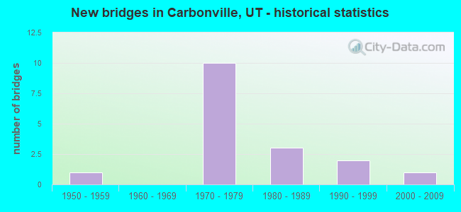
- New bridges - historical statistics
- 11950-1959
- 101970-1979
- 31980-1989
- 21990-1999
- 12000-2009


- Bridge Condition - Deck
- 55.6%Good
- 44.4%Satisfactory

- Bridge Condition - Superstructure
- 66.7%Good
- 33.3%Satisfactory

- Bridge Condition - Substructure
- 44.4%Good
- 55.6%Satisfactory

- Bridge Condition - Channel
- 54.5%Good
- 45.5%Satisfactory

- Bridge Condition - Culverts
- 50.0%Good
- 50.0%Satisfactory
Find on map >> Show street view
Structure Number: 7008F, Location: NORTHWEST OF PRICE (Lat: 39.617214, Lng: -110.844142), Route carried "on" structure: County highway 1341, Year Built: 1987, Status: Open, Structure Length: 4.24m (13.91ft), Average Daily Traffic: 710 (year 2020), Average Future Daily Traffic: 888 (year 2040), Design Load: HS 20+Mod, Features Intersected: PRICE RIVER, Facility Carried by Structure: CARBONVILLE ROAD
Minimum Vertical Clearance: 30+ m (98+ ft), Kilometerpoint: 2.788, Lanes on structure: 2, Owner: County Highway Agency, Approaching Roadway Width: 11.0m (36.1ft), Material/Design: Prestressed concrete, Design/Construction: Stringer/Multi-beam, Number Of Spans In Main Unit: 1, Length of Maximum Span: 41.9m (137.5ft), Curb-To-Curb Width: 11.0m (36.1ft), Out-to-Out Width: 12.2m (40.0ft)
Condition: Deck: Good, Superstructure: Good, Substructure: Good, Channel: Good, Operating Rating: 58.3 metric tons, Method Used To Determine Operating Rating: Load and Resistance Factor Rating (LRFR) rating reported by rating factor(RF) method using HL-93 loadings, Inventory Rating: 34.0 metric tons, Method Used To Determine Inventory Rating: Load Factor (LF) rating reported by rating factor (RF) method using MS18 loading, Structural Evaluation: Better than present minimum criteria, Deck Geometry: Better than present minimum criteria, Waterway Adequacy: Better than present minimum criteria, Approach Roadway Alignment: Better than present minimum criteria, Designated Inspection Frequency: Every 25 months, Inspection Date: May 2020, Deck Structure Type: Concrete Cast-file-Place, Wearing Surface/Protective System: Wearing Surface: Integral Concrete, Deck Protection: Epoxy Coated Reinforcing
Find on map >> Show street view
Structure Number: 7011C, Location: 760 NO.,1 MI. NW OF PRICE (Lat: 39.611189, Lng: -110.832272), Route carried "on" structure: County highway , Year Built: 1999, Status: Open, Structure Length: 2.93m (9.61ft), Average Daily Traffic: 63 (year 2020), Average Future Daily Traffic: 77 (year 2040), Design Load: HS 20+Mod, Features Intersected: PRICE RIVER, Facility Carried by Structure: 760 NO.ST.,CO.RD.
Minimum Vertical Clearance: 30+ m (98+ ft), Kilometerpoint: 0.202, Lanes on structure: 2, Owner: County Highway Agency, Approaching Roadway Width: 7.2m (23.6ft), Material/Design: Steel, Design/Construction: Stringer/Multi-beam, Number Of Spans In Main Unit: 1, Length of Maximum Span: 28.4m (93.2ft), Curb-To-Curb Width: 7.2m (23.6ft), Out-to-Out Width: 8.2m (26.9ft)
Condition: Deck: Good, Superstructure: Good, Substructure: Good, Channel: Good, Operating Rating: 60.6 metric tons, Method Used To Determine Operating Rating: Load and Resistance Factor Rating (LRFR) rating reported by rating factor(RF) method using HL-93 loadings, Inventory Rating: 48.9 metric tons, Method Used To Determine Inventory Rating: Load Factor (LF) rating reported by rating factor (RF) method using MS18 loading, Structural Evaluation: Better than present minimum criteria, Deck Geometry: Somewhat better than minimum adequacy, Waterway Adequacy: Equal to present desirable criteria, Approach Roadway Alignment: Equal to present desirable criteria, Designated Inspection Frequency: Every 25 months, Inspection Date: May 2020, Deck Structure Type: Concrete Cast-file-Place, Wearing Surface/Protective System: Wearing Surface: Monolithic Concrete, Deck Protection: Epoxy Coated Reinforcing
Find on map >> Show street view
Structure Number: 7019F, Location: 3.5 MILES NW. OF PRICE (Lat: 39.637339, Lng: -110.857850), Route carried "on" structure: County highway , Year Built: 1984, Status: Open, Structure Length: 2.09m (6.86ft), Average Daily Traffic: 315 (year 2020), Truck Traffic: 5%, Average Future Daily Traffic: 383 (year 2040), Design Load: HS 20+Mod, Features Intersected: PRICE RIVER, Facility Carried by Structure: COUNTY ROAD
Minimum Vertical Clearance: 30+ m (98+ ft), Kilometerpoint: 0.049, Lanes on structure: 2, Owner: County Highway Agency, Approaching Roadway Width: 8.8m (28.9ft), Material/Design: Prestressed concrete, Design/Construction: Tee Beam, Number Of Spans In Main Unit: 1, Length of Maximum Span: 20.1m (65.9ft), Curb-To-Curb Width: 8.8m (28.9ft), Out-to-Out Width: 9.8m (32.2ft)
Condition: Deck: Good, Superstructure: Good, Substructure: Satisfactory, Channel: Good, Operating Rating: 36.0 metric tons, Method Used To Determine Operating Rating: Load and Resistance Factor Rating (LRFR) rating reported by rating factor(RF) method using HL-93 loadings, Inventory Rating: 12.6 metric tons, Method Used To Determine Inventory Rating: Load Factor (LF) rating reported by rating factor (RF) method using MS18 loading, Structural Evaluation: Meets minimum limits, Deck Geometry: Equal to present minimum criteria, Waterway Adequacy: Equal to present minimum criteria, Approach Roadway Alignment: Equal to present desirable criteria, Designated Inspection Frequency: Every 25 months, Inspection Date: May 2020, Deck Structure Type: Other, Wearing Surface/Protective System: Wearing Surface: Bituminous
Find on map >> Show street view
Structure Number: 7026E, Location: CARBONVILLE ROAD (Lat: 39.638714, Lng: -110.857244), Route carried "on" structure: County highway 1332, Year Built: 1952, Status: Open, Structure Length: 0.66m (2.17ft), Average Daily Traffic: 3,084 (year 2020), Average Future Daily Traffic: 3,855 (year 2040), Design Load: H 15, Features Intersected: PRICE CANAL, Facility Carried by Structure: CO. RD. (OLD SR-6)
Minimum Vertical Clearance: 30+ m (98+ ft), Kilometerpoint: 5.364, Lanes on structure: 2, Owner: County Highway Agency, Approaching Roadway Width: 11.6m (38.1ft), Skew: 4 degrees, Material/Design: Concrete, Design/Construction: Culvert, Number Of Spans In Main Unit: 1, Number Of Approach Spans: 2, Length of Maximum Span: 6.1m (20.0ft)
Condition: Channel: Satisfactory, Culverts: Good, Operating Rating: 38.9 metric tons, Method Used To Determine Operating Rating: Load Factor (LF) rating reported by rating factor (RF) method using MS18 loading, Inventory Rating: 22.0 metric tons, Method Used To Determine Inventory Rating: Load Factor (LF) rating reported by rating factor (RF) method using MS18 loading, Structural Evaluation: Somewhat better than minimum adequacy, Waterway Adequacy: Equal to present minimum criteria, Approach Roadway Alignment: Equal to present desirable criteria, Designated Inspection Frequency: Every 25 months, Inspection Date: May 2020
Find on map >> Show street view
Structure Number: 7039C, Location: IN CARBONVILLE (Lat: 39.631439, Lng: -110.847839), Route carried "on" structure: County highway , Year Built: 1994, Status: Open, Structure Length: 0.80m (2.62ft), Average Daily Traffic: 139 (year 2020), Truck Traffic: 1%, Average Future Daily Traffic: 168 (year 2040), Design Load: HS 20+Mod, Features Intersected: PRICE CANAL, Facility Carried by Structure: COUNTY ROAD
Minimum Vertical Clearance: 30+ m (98+ ft), Kilometerpoint: 0.017, Lanes on structure: 2, Owner: County Highway Agency, Approaching Roadway Width: 7.3m (24.0ft), Skew: 4 degrees, Material/Design: Steel, Design/Construction: Stringer/Multi-beam, Number Of Spans In Main Unit: 1, Length of Maximum Span: 7.3m (24.0ft), Curb-To-Curb Width: 7.3m (24.0ft), Out-to-Out Width: 7.3m (24.0ft)
Condition: Deck: Satisfactory, Superstructure: Satisfactory, Substructure: Good, Channel: Good, Operating Rating: 32.7 metric tons, Method Used To Determine Operating Rating: Load and Resistance Factor Rating (LRFR) rating reported by rating factor(RF) method using HL-93 loadings, Inventory Rating: 31.4 metric tons, Method Used To Determine Inventory Rating: Load Factor (LF) rating reported by rating factor (RF) method using MS18 loading, Structural Evaluation: Equal to present minimum criteria, Deck Geometry: Somewhat better than minimum adequacy, Waterway Adequacy: Equal to present minimum criteria, Approach Roadway Alignment: Equal to present minimum criteria, Designated Inspection Frequency: Every 25 months, Inspection Date: May 2020, Deck Structure Type: Corrugated Steel, Wearing Surface/Protective System: Wearing Surface: Bituminous
Find on map >> Show street view
Structure Number: 7040D, Location: IN CARBONVILLE (Lat: 39.628658, Lng: -110.844061), Route carried "on" structure: County highway , Year Built: 1989, Status: Open, Structure Length: 0.96m (3.15ft), Average Daily Traffic: 378 (year 2020), Truck Traffic: 1%, Average Future Daily Traffic: 459 (year 2040), Design Load: HS 20+Mod, Features Intersected: PRICE CANAL, Facility Carried by Structure: COUNTY ROAD
Minimum Vertical Clearance: 30+ m (98+ ft), Kilometerpoint: 0.130, Lanes on structure: 2, Owner: County Highway Agency, Approaching Roadway Width: 7.3m (24.0ft), Skew: 4 degrees, Material/Design: Concrete, Design/Construction: Slab, Number Of Spans In Main Unit: 1, Length of Maximum Span: 8.1m (26.6ft), Curb-To-Curb Width: 7.3m (24.0ft), Out-to-Out Width: 9.2m (30.2ft)
Condition: Deck: Satisfactory, Superstructure: Satisfactory, Substructure: Good, Channel: Satisfactory, Operating Rating: 32.4 metric tons, Method Used To Determine Operating Rating: Load and Resistance Factor Rating (LRFR) rating reported by rating factor(RF) method using HL-93 loadings, Inventory Rating: 21.1 metric tons, Method Used To Determine Inventory Rating: Load and Resistance Factor Rating (LRFR) rating reported by rating factor(RF) method using HL-93 loadings, Structural Evaluation: Equal to present minimum criteria, Deck Geometry: Somewhat better than minimum adequacy, Waterway Adequacy: Somewhat better than minimum adequacy, Approach Roadway Alignment: Equal to present minimum criteria, Designated Inspection Frequency: Every 25 months, Inspection Date: May 2020, Deck Structure Type: Concrete Cast-file-Place, Wearing Surface/Protective System: Wearing Surface: Bituminous
Find on map >> Show street view
Structure Number: 7041E, Location: CARBONVILLE ROAD (Lat: 39.633575, Lng: -110.851522), Route carried "on" structure: County highway 1332, Year Built: 2008, Status: Posted for load, Structure Length: 0.76m (2.49ft), Average Daily Traffic: 3,084 (year 2020), Average Future Daily Traffic: 3,855 (year 2040), Design Load: HS 20+Mod, Features Intersected: PRICE CANAL, Facility Carried by Structure: CARBONVILLE ROAD
Minimum Vertical Clearance: 30+ m (98+ ft), Kilometerpoint: 4.609, Lanes on structure: 2, Owner: County Highway Agency, Approaching Roadway Width: 14.3m (46.9ft), Skew: 3 degrees, Material/Design: Concrete, Design/Construction: Culvert, Number Of Spans In Main Unit: 1, Length of Maximum Span: 7.0m (23.0ft)
Condition: Channel: Good, Culverts: Good, Operating Rating: 32.4 metric tons, Method Used To Determine Operating Rating: Load and Resistance Factor Rating (LRFR) rating reported by rating factor(RF) method using HL-93 loadings, Inventory Rating: 20.1 metric tons, Method Used To Determine Inventory Rating: Load and Resistance Factor Rating (LRFR) rating reported by rating factor(RF) method using HL-93 loadings, Structural Evaluation: Somewhat better than minimum adequacy, Waterway Adequacy: Better than present minimum criteria, Approach Roadway Alignment: Equal to present desirable criteria, Designated Inspection Frequency: Every 25 months, Inspection Date: May 2020
Find on map >> Show street view
Structure Number: E2026, Location: 1.3 MILE SO. OF BLUE CUT (Lat: 39.637158, Lng: -110.860925), Route carried "on" structure: US 6, Year Built: 1978, Status: Open, Structure Length: 0.88m (2.89ft), Average Daily Traffic: 12,644 (year 2020), Truck Traffic: 25%, Average Future Daily Traffic: 15,805 (year 2040), Design Load: HS 20+Mod, Features Intersected: CARBON CANAL
Minimum Vertical Clearance: 30+ m (98+ ft), Kilometerpoint: 380.873, Lanes on structure: 4, Base Highway Network: Yes, Owner: State Highway Agency, Approaching Roadway Width: 25.0m (82.0ft), Skew: 25 degrees, Material/Design: Concrete, Design/Construction: Culvert, Number Of Spans In Main Unit: 1, Length of Maximum Span: 7.3m (24.0ft)
Condition: Channel: Good, Culverts: Satisfactory, Operating Rating: 81.6 metric tons, Method Used To Determine Operating Rating: Load and Resistance Factor Rating (LRFR) rating reported by rating factor(RF) method using HL-93 loadings, Inventory Rating: 54.1 metric tons, Method Used To Determine Inventory Rating: Load and Resistance Factor Rating (LRFR) rating reported by rating factor(RF) method using HL-93 loadings, Structural Evaluation: Equal to present minimum criteria, Waterway Adequacy: Equal to present desirable criteria, Approach Roadway Alignment: Equal to present desirable criteria, Designated Inspection Frequency: Every 24 months, Inspection Date: August 2021
Find on map >> Show street view
Structure Number: H 933G, Location: 5 MILE NW OF PRICE (Lat: 39.617233, Lng: -110.852867), Route carried "on" structure: US 6, Year Built: 1978, Status: Open, Structure Length: 0.79m (2.59ft), Average Daily Traffic: 12,644 (year 2020), Truck Traffic: 25%, Average Future Daily Traffic: 15,805 (year 2040), Design Load: HS 20, Features Intersected: GORDON CREEK
Minimum Vertical Clearance: 30+ m (98+ ft), Kilometerpoint: 383.317, Lanes on structure: 4, Base Highway Network: Yes, Owner: State Highway Agency, Approaching Roadway Width: 26.8m (87.9ft), Skew: 24 degrees, Material/Design: Steel, Design/Construction: Culvert, Number Of Spans In Main Unit: 1, Length of Maximum Span: 7.9m (25.9ft)
Condition: Channel: Satisfactory, Culverts: Satisfactory, Waterway Adequacy: Better than present minimum criteria, Approach Roadway Alignment: Equal to present desirable criteria, Designated Inspection Frequency: Every 24 months, Inspection Date: August 2021
Find on map >> Show street view
Structure Number: 2F 39, Location: 3 MILES SOUTH OF HELPER (Lat: 39.639478, Lng: -110.859850), Route carried "on" structure: US 6, Year Built: 1978, Status: Open, Structure Length: 5.53m (18.14ft), Average Daily Traffic: 12,644 (year 2020), Truck Traffic: 25%, Average Future Daily Traffic: 15,805 (year 2040), Design Load: HS 20+Mod, Features Intersected: PRICE RIVER & CO. RO
Minimum Vertical Clearance: 30+ m (98+ ft), Kilometerpoint: 380.600, Lanes on structure: 2, Lanes under structure: 2, Base Highway Network: Yes, Owner: State Highway Agency, Approaching Roadway Width: 12.5m (41.0ft), Skew: 10 degrees, Material/Design: Prestressed concrete continuous, Design/Construction: Stringer/Multi-beam, Number Of Spans In Main Unit: 2, Length of Maximum Span: 27.3m (89.6ft), Curb-To-Curb Width: 12.5m (41.0ft), Out-to-Out Width: 13.7m (44.9ft)
Condition: Deck: Good, Superstructure: Good, Substructure: Satisfactory, Channel: Satisfactory, Operating Rating: 43.4 metric tons, Method Used To Determine Operating Rating: Load and Resistance Factor Rating (LRFR) rating reported by rating factor(RF) method using HL-93 loadings, Inventory Rating: 25.3 metric tons, Method Used To Determine Inventory Rating: Load Factor (LF) rating reported by rating factor (RF) method using MS18 loading, Structural Evaluation: Equal to present minimum criteria, Deck Geometry: Better than present minimum criteria, Underclear: Meets minimum limits, Waterway Adequacy: Equal to present desirable criteria, Approach Roadway Alignment: Equal to present desirable criteria, Designated Inspection Frequency: Every 24 months, Inspection Date: August 2021, Deck Structure Type: Concrete Cast-file-Place, Wearing Surface/Protective System: Wearing Surface: Bituminous, Membrane: Preformed Fabric
Find on map >> Show street view
Structure Number: 2F 427, Location: 4.5 MI.NORTHWEST OF PRICE (Lat: 39.615861, Lng: -110.844414), Route carried "on" structure: US 6, Year Built: 1978, Status: Open, Structure Length: 2.55m (8.37ft), Average Daily Traffic: 12,644 (year 2020), Truck Traffic: 25%, Average Future Daily Traffic: 15,805 (year 2040), Design Load: HS 20+Mod, Features Intersected: COUNTY ACCESS ROAD
Minimum Vertical Clearance: 30+ m (98+ ft), Kilometerpoint: 384.074, Lanes on structure: 2, Lanes under structure: 2, Base Highway Network: Yes, Owner: State Highway Agency, Approaching Roadway Width: 12.4m (40.7ft), Skew: 10 degrees, Material/Design: Prestressed concrete, Design/Construction: Stringer/Multi-beam, Number Of Spans In Main Unit: 1, Length of Maximum Span: 24.8m (81.4ft), Curb-To-Curb Width: 12.4m (40.7ft), Out-to-Out Width: 13.4m (44.0ft)
Condition: Deck: Satisfactory, Superstructure: Good, Substructure: Satisfactory, Operating Rating: 37.3 metric tons, Method Used To Determine Operating Rating: Load and Resistance Factor Rating (LRFR) rating reported by rating factor(RF) method using HL-93 loadings, Inventory Rating: 36.9 metric tons, Method Used To Determine Inventory Rating: Load Factor (LF) rating reported by rating factor (RF) method using MS18 loading, Structural Evaluation: Equal to present minimum criteria, Deck Geometry: Better than present minimum criteria, Underclear: Meets minimum limits, Approach Roadway Alignment: Equal to present desirable criteria, Designated Inspection Frequency: Every 24 months, Inspection Date: August 2021, Deck Structure Type: Concrete Cast-file-Place, Wearing Surface/Protective System: Wearing Surface: Bituminous, Membrane: Preformed Fabric, Deck Protection: Epoxy Coated Reinforcing
Find on map >> Show street view
Structure Number: 4F 39, Location: 3 MILES S. OF HELPER (Lat: 39.638897, Lng: -110.859767), Route carried "on" structure: US 6, Year Built: 1978, Status: Open, Structure Length: 5.53m (18.14ft), Average Daily Traffic: 430 (year 2020), Truck Traffic: 48%, Average Future Daily Traffic: 538 (year 2040), Design Load: HS 20+Mod, Features Intersected: PRICE RIVER & CO. RD.
Minimum Vertical Clearance: 30+ m (98+ ft), Kilometerpoint: 0.175, Lanes on structure: 2, Lanes under structure: 2, Base Highway Network: Yes, Owner: State Highway Agency, Approaching Roadway Width: 12.5m (41.0ft), Skew: 10 degrees, Material/Design: Prestressed concrete continuous, Design/Construction: Stringer/Multi-beam, Number Of Spans In Main Unit: 2, Length of Maximum Span: 27.3m (89.6ft), Curb-To-Curb Width: 12.5m (41.0ft), Out-to-Out Width: 13.7m (44.9ft)
Condition: Deck: Good, Superstructure: Good, Substructure: Satisfactory, Channel: Satisfactory, Operating Rating: 43.4 metric tons, Method Used To Determine Operating Rating: Load and Resistance Factor Rating (LRFR) rating reported by rating factor(RF) method using HL-93 loadings, Inventory Rating: 25.3 metric tons, Method Used To Determine Inventory Rating: Load Factor (LF) rating reported by rating factor (RF) method using MS18 loading, Structural Evaluation: Equal to present minimum criteria, Deck Geometry: Better than present minimum criteria, Underclear: Meets minimum limits, Waterway Adequacy: Equal to present desirable criteria, Approach Roadway Alignment: Equal to present desirable criteria, Designated Inspection Frequency: Every 24 months, Inspection Date: August 2021, Deck Structure Type: Concrete Cast-file-Place, Wearing Surface/Protective System: Wearing Surface: Bituminous, Membrane: Preformed Fabric
Find on map >> Show street view
Structure Number: 4F 427, Location: 4.5 MI NW OF PRICE (Lat: 39.616097, Lng: -110.843994), Route carried "on" structure: US 6, Year Built: 1978, Status: Open, Structure Length: 2.55m (8.37ft), Average Daily Traffic: 430 (year 2020), Truck Traffic: 48%, Average Future Daily Traffic: 538 (year 2040), Design Load: HS 20+Mod, Features Intersected: COUNTY ACCESS ROAD
Minimum Vertical Clearance: 30+ m (98+ ft), Kilometerpoint: 3.573, Lanes on structure: 2, Lanes under structure: 2, Base Highway Network: Yes, Owner: State Highway Agency, Approaching Roadway Width: 12.4m (40.7ft), Skew: 10 degrees, Material/Design: Prestressed concrete, Design/Construction: Stringer/Multi-beam, Number Of Spans In Main Unit: 1, Length of Maximum Span: 24.8m (81.4ft), Curb-To-Curb Width: 12.4m (40.7ft), Out-to-Out Width: 13.4m (44.0ft)
Condition: Deck: Satisfactory, Superstructure: Satisfactory, Substructure: Satisfactory, Operating Rating: 37.3 metric tons, Method Used To Determine Operating Rating: Load and Resistance Factor Rating (LRFR) rating reported by rating factor(RF) method using HL-93 loadings, Inventory Rating: 36.9 metric tons, Method Used To Determine Inventory Rating: Load Factor (LF) rating reported by rating factor (RF) method using MS18 loading, Structural Evaluation: Equal to present minimum criteria, Deck Geometry: Better than present minimum criteria, Underclear: Meets minimum limits, Approach Roadway Alignment: Equal to present desirable criteria, Designated Inspection Frequency: Every 24 months, Inspection Date: August 2021, Deck Structure Type: Concrete Cast-file-Place, Wearing Surface/Protective System: Wearing Surface: Bituminous, Membrane: Preformed Fabric
Find on map >> Show street view
Structure Number: 2F 39, Location: 3 MILES SOUTH OF HELPER (Lat: 39.639478, Lng: -110.859850), Route carried "under" structure: County highway , Year Built: 1978, Structure Length: 0. m, Features Intersected: PRICE RIVER & CO. RO, Facility Carried by Structure: US-6 (SR-6) EBL
Minimum Vertical Clearance: 4.93m (16.17ft), Kilometerpoint: 0.000, Lanes on structure: 2, Lanes under structure: 2, Material/Design: Prestressed concrete continuous, Design/Construction: Stringer/Multi-beam, Length of Maximum Span: 27.3m (89.6ft)
Find on map >> Show street view
Structure Number: 2F 427, Location: 4.5 MI.NORTHWEST OF PRICE (Lat: 39.615861, Lng: -110.844414), Route carried "under" structure: County highway 1341, Year Built: 1978, Structure Length: 0. m, Average Daily Traffic: 5,888 (year 2020), Features Intersected: COUNTY ACCESS ROAD, Facility Carried by Structure: US-6 (SR-6) EBL
Minimum Vertical Clearance: 4.85m (15.91ft), Kilometerpoint: 0.000, Lanes on structure: 2, Lanes under structure: 2, Material/Design: Prestressed concrete, Design/Construction: Stringer/Multi-beam, Length of Maximum Span: 24.8m (81.4ft)
Find on map >> Show street view
Structure Number: 4F 39, Location: 3 MILES S. OF HELPER (Lat: 39.638897, Lng: -110.859767), Route carried "under" structure: County highway , Year Built: 1978, Structure Length: 0. m, Features Intersected: PRICE RIVER & CO. RD., Facility Carried by Structure: US-6 (SR-6) WBL
Minimum Vertical Clearance: 5.49m (18.01ft), Kilometerpoint: 0.000, Lanes on structure: 2, Lanes under structure: 2, Material/Design: Prestressed concrete continuous, Design/Construction: Stringer/Multi-beam, Length of Maximum Span: 27.3m (89.6ft)
Find on map >> Show street view
Structure Number: 4F 427, Location: 4.5 MI NW OF PRICE (Lat: 39.616097, Lng: -110.843994), Route carried "under" structure: County highway 1341, Year Built: 1978, Structure Length: 0. m, Average Daily Traffic: 5,888 (year 2020), Features Intersected: COUNTY ACCESS ROAD, Facility Carried by Structure: US-6 (SR-6) WBL
Minimum Vertical Clearance: 4.72m (15.49ft), Kilometerpoint: 0.000, Lanes on structure: 2, Lanes under structure: 2, Material/Design: Prestressed concrete, Design/Construction: Stringer/Multi-beam, Length of Maximum Span: 24.8m (81.4ft)