Bridge Statistics for Carolina, Alabama (AL)
Condition, Traffic, Stress, Structural Evaluation, Project Costs
- National Bridge Inventory (NBI) Statistics
- 24Number of bridges
- 325ft / 99.2mTotal length
- $32,256,000Total costs
- 129,194Total average daily traffic
- 16,801Total average daily truck traffic
- 172,187Total future (year 2030) average daily traffic
- National Bridge Inventory (NBI) Registered Bridges for Carolina
- No street view available for this location
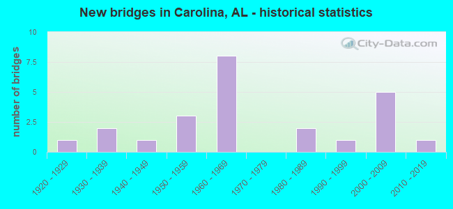
- New bridges - historical statistics
- 11920-1929
- 21930-1939
- 11940-1949
- 31950-1959
- 81960-1969
- 21980-1989
- 11990-1999
- 52000-2009
- 12010-2019

- Reconstructed bridges - Historical Statistics
- 21960-1969
- 21970-1979
- 01980-1989
- 11990-1999


- Bridge Condition - Deck
- 6.3%Excellent
- 18.8%Very good
- 31.3%Good
- 31.3%Satisfactory
- 12.5%Fair

- Bridge Condition - Superstructure
- 6.3%Excellent
- 12.5%Very good
- 25.0%Good
- 50.0%Satisfactory
- 6.3%Fair

- Bridge Condition - Substructure
- 6.3%Excellent
- 12.5%Very good
- 18.8%Good
- 43.8%Satisfactory
- 12.5%Fair
- 6.3%Poor

- Bridge Condition - Channel
- 15.0%Very good
- 25.0%Good
- 55.0%Satisfactory
- 5.0%Fair

- Bridge Condition - Culverts
- 12.5%Very good
- 25.0%Good
- 50.0%Satisfactory
- 12.5%Fair
Find on map >> Show street view
Structure Number: 2684, Location: 4.1 MI S OF OXFORD (Lat: 33.553700, Lng: -85.886900), Route carried "on" structure: State highway 21, Year Built: 1942, Status: Open, Structure Length: 1.30m (4.27ft), Average Daily Traffic: 5,506 (year 2019), Truck Traffic: 6%, Average Future Daily Traffic: 7,708 (year 2039), Design Load: H 15, Features Intersected: TUSKEHADKY BRANCH
Minimum Vertical Clearance: 30+ m (98+ ft), Kilometerpoint: 395.673, Lanes on structure: 2, Base Highway Network: Yes, Owner: State Highway Agency, Approaching Roadway Width: 10.8m (35.4ft), Material/Design: Concrete, Design/Construction: Culvert, Number Of Spans In Main Unit: 4, Length of Maximum Span: 3.0m (9.8ft), Curb-To-Curb Width: 9.0m (29.5ft), Out-to-Out Width: 9.8m (32.2ft)
Condition: Channel: Satisfactory, Culverts: Fair, Operating Rating: 40.7 metric tons, Method Used To Determine Operating Rating: Load Factor (LF), Inventory Rating: 24.4 metric tons, Method Used To Determine Inventory Rating: Load Factor (LF), Structural Evaluation: Somewhat better than minimum adequacy, Deck Geometry: High priority of corrective action, Waterway Adequacy: Equal to present minimum criteria, Approach Roadway Alignment: Equal to present desirable criteria, Length Of Structure Improvement: 1.98m (6.50ft), Designated Inspection Frequency: Every 24 months, Inspection Date: July 2021, Bridge Improvement Cost: $354,000, Roadway Improvement Cost: $35,000, Total Project Cost: $389,000 ( Estimate for 2022), Deck Structure Type: Concrete Cast-file-Place
Find on map >> Show street view
Structure Number: 4042, Location: 3 MI S OF ANDALUSIA (Lat: 31.242625, Lng: -86.497564), Route carried "on" structure: County highway 17, Year Built: 1951, Status: Open, Structure Length: 0.78m (2.56ft), Average Daily Traffic: 110 (year 1994), Truck Traffic: 5%, Average Future Daily Traffic: 140 (year 2030), Design Load: H 15, Features Intersected: NO NAME BRANCH
Minimum Vertical Clearance: 30+ m (98+ ft), Kilometerpoint: 0.010, Lanes on structure: 2, Owner: County Highway Agency, Approaching Roadway Width: 9.1m (29.9ft), Material/Design: Concrete, Design/Construction: Culvert, Number Of Spans In Main Unit: 3, Length of Maximum Span: 2.4m (7.9ft)
Condition: Channel: Satisfactory, Culverts: Satisfactory, Operating Rating: 48.4 metric tons, Method Used To Determine Operating Rating: Load Factor (LF), Inventory Rating: 29.3 metric tons, Method Used To Determine Inventory Rating: Load Factor (LF), Structural Evaluation: Equal to present minimum criteria, Waterway Adequacy: Better than present minimum criteria, Approach Roadway Alignment: Equal to present desirable criteria, Length Of Structure Improvement: 1.44m (4.72ft), Designated Inspection Frequency: Every 24 months, Inspection Date: August 2020, Bridge Improvement Cost: $249,000, Roadway Improvement Cost: $25,000, Total Project Cost: $274,000 ( Estimate for 2022), Wearing Surface/Protective System: Wearing Surface: Bituminous
Find on map >> Show street view
Structure Number: 437, Location: 5 1/2 MI W OF ANDALUSIA (Lat: 31.277553, Lng: -86.569303), Route carried "on" structure: County highway 42, Year Built: 1952, Status: Open, Structure Length: 21.15m (69.39ft), Average Daily Traffic: 1,060 (year 1994), Truck Traffic: 7%, Average Future Daily Traffic: 1,320 (year 2030), Design Load: H 20, Features Intersected: CONECUH RIVER
Minimum Vertical Clearance: 30+ m (98+ ft), Kilometerpoint: 0.010, Lanes on structure: 2, Owner: County Highway Agency, Approaching Roadway Width: 9.8m (32.2ft), Material/Design: Concrete continuous, Design/Construction: Tee Beam, Number Of Spans In Main Unit: 3, Number Of Approach Spans: 13, Length of Maximum Span: 30.5m (100.1ft), Curb-To-Curb Width: 7.2m (23.6ft), Out-to-Out Width: 8.4m (27.6ft)
Condition: Deck: Good, Superstructure: Satisfactory, Substructure: Good, Channel: Satisfactory, Operating Rating: 38.4 metric tons, Method Used To Determine Operating Rating: Load Factor (LF), Inventory Rating: 23.0 metric tons, Method Used To Determine Inventory Rating: Load Factor (LF), Structural Evaluation: Equal to present minimum criteria, Deck Geometry: High priority of corrective action, Waterway Adequacy: Equal to present desirable criteria, Approach Roadway Alignment: Equal to present desirable criteria, Length Of Structure Improvement: 21.15m (69.39ft), Designated Inspection Frequency: Every 24 months, Inspection Date: September 2020, Bridge Improvement Cost: $3,916,000, Roadway Improvement Cost: $392,000, Total Project Cost: $4,308,000 ( Estimate for 2022), Deck Structure Type: Concrete Cast-file-Place
Find on map >> Show street view
Structure Number: 7224, Location: ARGO INTERCHANGE (Lat: 33.695850, Lng: -86.527153), Route carried "on" structure: County highway , Year Built: 1961, Status: Open, Structure Length: 8.08m (26.51ft), Average Daily Traffic: 1,500 (year 2021), Truck Traffic: 2%, Average Future Daily Traffic: 3,000 (year 2041), Design Load: HS 20, Features Intersected: I 59, Facility Carried by Structure: ARGO PARKWAY
Minimum Vertical Clearance: 30+ m (98+ ft), Kilometerpoint: 0.010, Lanes on structure: 2, Lanes under structure: 4, Owner: State Highway Agency, Approaching Roadway Width: 10.4m (34.1ft), Skew: 3 degrees, Material/Design: Concrete continuous, Design/Construction: Tee Beam, Number Of Spans In Main Unit: 4, Length of Maximum Span: 22.3m (73.2ft), Curb-To-Curb Width: 8.5m (27.9ft), Out-to-Out Width: 9.4m (30.8ft)
Condition: Deck: Satisfactory, Superstructure: Satisfactory, Substructure: Satisfactory, Operating Rating: 46.2 metric tons, Method Used To Determine Operating Rating: Load Factor (LF), Inventory Rating: 27.7 metric tons, Method Used To Determine Inventory Rating: Load Factor (LF), Structural Evaluation: Equal to present minimum criteria, Deck Geometry: Somewhat better than minimum adequacy, Underclear: Equal to present minimum criteria, Approach Roadway Alignment: Equal to present minimum criteria, Length Of Structure Improvement: 9.08m (29.79ft), Designated Inspection Frequency: Every 24 months, Inspection Date: July 2021, Bridge Improvement Cost: $1,868,000, Roadway Improvement Cost: $187,000, Total Project Cost: $2,055,000 ( Estimate for 2022), Deck Structure Type: Concrete Cast-file-Place
Find on map >> Show street view
Structure Number: 9008, Location: 0.9 MI N OF MITYLENE EXIT (Lat: 32.366692, Lng: -86.116811), Route carried "on" structure: Interstate 85, Year Built: 1966, Status: Open, Structure Length: 8.29m (27.20ft), Average Daily Traffic: 19,245 (year 2013), Truck Traffic: 20%, Average Future Daily Traffic: 25,364 (year 2033), Design Load: HS 20, Features Intersected: JENKINS CRK
Minimum Vertical Clearance: 30+ m (98+ ft), Kilometerpoint: 18.989, Lanes on structure: 2, Base Highway Network: Yes, Owner: State Highway Agency, Approaching Roadway Width: 12.2m (40.0ft), Skew: 10 degrees, Material/Design: Concrete, Design/Construction: Tee Beam, Number Of Spans In Main Unit: 8, Length of Maximum Span: 10.4m (34.1ft), Curb-To-Curb Width: 8.5m (27.9ft), Out-to-Out Width: 10.1m (33.1ft)
Condition: Deck: Fair, Superstructure: Satisfactory, Substructure: Satisfactory, Channel: Good, Operating Rating: 48.3 metric tons, Method Used To Determine Operating Rating: Load Factor (LF), Inventory Rating: 28.9 metric tons, Method Used To Determine Inventory Rating: Load Factor (LF), Structural Evaluation: Equal to present minimum criteria, Deck Geometry: High priority of corrective action, Waterway Adequacy: Better than present minimum criteria, Approach Roadway Alignment: Better than present minimum criteria, Length Of Structure Improvement: 9.29m (30.48ft), Designated Inspection Frequency: Every 24 months, Inspection Date: May 2021, Bridge Improvement Cost: $2,102,000, Roadway Improvement Cost: $210,000, Total Project Cost: $2,312,000 ( Estimate for 2022), Deck Structure Type: Concrete Cast-file-Place
Find on map >> Show street view
Structure Number: 9009, Location: 0.9 MI N OF MITYLENE EXIT (Lat: 32.366689, Lng: -86.116808), Route carried "on" structure: Interstate 85, Year Built: 1966, Status: Open, Structure Length: 8.29m (27.20ft), Average Daily Traffic: 19,245 (year 2013), Truck Traffic: 20%, Average Future Daily Traffic: 25,364 (year 2033), Design Load: HS 20, Features Intersected: JENKINS CRK
Minimum Vertical Clearance: 30+ m (98+ ft), Kilometerpoint: 18.989, Lanes on structure: 2, Base Highway Network: Yes, Owner: State Highway Agency, Approaching Roadway Width: 12.2m (40.0ft), Skew: 10 degrees, Material/Design: Concrete, Design/Construction: Tee Beam, Number Of Spans In Main Unit: 8, Length of Maximum Span: 10.4m (34.1ft), Curb-To-Curb Width: 8.5m (27.9ft), Out-to-Out Width: 10.1m (33.1ft)
Condition: Deck: Fair, Superstructure: Satisfactory, Substructure: Satisfactory, Channel: Good, Operating Rating: 47.4 metric tons, Method Used To Determine Operating Rating: Load Factor (LF), Inventory Rating: 28.5 metric tons, Method Used To Determine Inventory Rating: Load Factor (LF), Structural Evaluation: Equal to present minimum criteria, Deck Geometry: High priority of corrective action, Waterway Adequacy: Better than present minimum criteria, Approach Roadway Alignment: Better than present minimum criteria, Length Of Structure Improvement: 9.29m (30.48ft), Designated Inspection Frequency: Every 24 months, Inspection Date: May 2021, Bridge Improvement Cost: $2,102,000, Roadway Improvement Cost: $210,000, Total Project Cost: $2,312,000 ( Estimate for 2022), Deck Structure Type: Concrete Cast-file-Place
Find on map >> Show street view
Structure Number: 9469, Location: 3 MI S OF SULPHUR SPRINGS (Lat: 33.898167, Lng: -86.897214), Route carried "on" structure: County highway 400, Year Built: 1967, Status: Open, Structure Length: 0.61m (2.00ft), Average Daily Traffic: 640 (year 2020), Truck Traffic: 10%, Average Future Daily Traffic: 951 (year 2040), Design Load: H 15, Features Intersected: ISABELLE CREEK, Facility Carried by Structure: COUNTY ROAD 5
Minimum Vertical Clearance: 30+ m (98+ ft), Kilometerpoint: 0.010, Lanes on structure: 2, Owner: County Highway Agency, Approaching Roadway Width: 10.1m (33.1ft), Material/Design: Concrete, Design/Construction: Culvert, Number Of Spans In Main Unit: 2, Length of Maximum Span: 3.0m (9.8ft)
Condition: Channel: Fair, Culverts: Satisfactory, Operating Rating: 88.9 metric tons, Method Used To Determine Operating Rating: Load Factor (LF), Inventory Rating: 57.9 metric tons, Method Used To Determine Inventory Rating: Load Factor (LF), Structural Evaluation: Equal to present minimum criteria, Waterway Adequacy: Somewhat better than minimum adequacy, Approach Roadway Alignment: Better than present minimum criteria, Length Of Structure Improvement: 1.22m (4.00ft), Designated Inspection Frequency: Every 24 months, Inspection Date: November 2020, Bridge Improvement Cost: $275,000, Roadway Improvement Cost: $28,000, Total Project Cost: $303,000 ( Estimate for 2022)
Find on map >> Show street view
Structure Number: 9517, Location: I 59 * ARRON ARONOV DR. (Lat: 33.476111, Lng: -86.926108), Route carried "on" structure: Interstate 20, Year Built: 1968, Status: Open, Structure Length: 8.08m (26.51ft), Average Daily Traffic: 41,990 (year 2021), Truck Traffic: 12%, Average Future Daily Traffic: 51,950 (year 2041), Design Load: HS 20, Features Intersected: ARRON ARONOV DRIVE
Minimum Vertical Clearance: 30+ m (98+ ft), Kilometerpoint: 190.982, Lanes on structure: 2, Lanes under structure: 4, Base Highway Network: Yes, Owner: State Highway Agency, Approaching Roadway Width: 11.8m (38.7ft), Skew: 10 degrees, Material/Design: Concrete continuous, Design/Construction: Tee Beam, Number Of Spans In Main Unit: 4, Length of Maximum Span: 22.3m (73.2ft), Curb-To-Curb Width: 8.5m (27.9ft), Out-to-Out Width: 9.4m (30.8ft)
Condition: Deck: Satisfactory, Superstructure: Satisfactory, Substructure: Poor, Operating Rating: 46.7 metric tons, Method Used To Determine Operating Rating: Load Factor (LF), Inventory Rating: 27.9 metric tons, Method Used To Determine Inventory Rating: Load Factor (LF), Structural Evaluation: Meets minimum limits, Deck Geometry: High priority of corrective action, Underclear: Somewhat better than minimum adequacy, Approach Roadway Alignment: Equal to present desirable criteria, Length Of Structure Improvement: 9.08m (29.79ft), Designated Inspection Frequency: Every 24 months, Other Special Inspection Frequency: Every 12 months, Inspection Date: November 2021, Other Special Inspection Date: November 2021, Bridge Improvement Cost: $1,868,000, Roadway Improvement Cost: $187,000, Total Project Cost: $2,055,000 ( Estimate for 2022), Deck Structure Type: Closed Grating, Wearing Surface/Protective System: Wearing Surface: Bituminous
Find on map >> Show street view
Structure Number: 9801, Location: .4 MI W AL 117 T6 R10 (Lat: 34.534986, Lng: -85.532044), Route carried "on" structure: County highway 181, Year Built: 1968, Status: Posted for load, Structure Length: 0.84m (2.76ft), Average Daily Traffic: 260 (year 2021), Truck Traffic: 5%, Average Future Daily Traffic: 386 (year 2041), Design Load: H 10, Features Intersected: BRUSH CREEK, Facility Carried by Structure: CO RT 106
Minimum Vertical Clearance: 30+ m (98+ ft), Kilometerpoint: 0.010, Lanes on structure: 2, Owner: County Highway Agency, Approaching Roadway Width: 5.8m (19.0ft), Material/Design: Steel, Design/Construction: Stringer/Multi-beam, Number Of Spans In Main Unit: 1, Length of Maximum Span: 8.4m (27.6ft), Curb-To-Curb Width: 6.8m (22.3ft), Out-to-Out Width: 7.2m (23.6ft)
Condition: Deck: Good, Superstructure: Satisfactory, Substructure: Satisfactory, Channel: Satisfactory, Operating Rating: 12.0 metric tons, Method Used To Determine Operating Rating: Allowable Stress (AS), Inventory Rating: 5.3 metric tons, Method Used To Determine Inventory Rating: Allowable Stress (AS), Structural Evaluation: High priority of replacement, Deck Geometry: Meets minimum limits, Waterway Adequacy: Equal to present desirable criteria, Approach Roadway Alignment: Meets minimum limits, Bridge Posting: Required (Relationship of Operating Rating to Maximum Legal Load: > 39.9% below), Length Of Structure Improvement: 1.50m (4.92ft), Designated Inspection Frequency: Every 24 months, Other Special Inspection Frequency: Every 12 months, Inspection Date: July 2021, Other Special Inspection Date: July 2021, Bridge Improvement Cost: $236,000, Roadway Improvement Cost: $24,000, Total Project Cost: $260,000 ( Estimate for 2022), Deck Structure Type: Concrete Cast-file-Place
Find on map >> Show street view
Structure Number: 9837, Location: 7 MI S JCT US 72 * SR 79 (Lat: 34.592239, Lng: -86.091214), Route carried "on" structure: State highway 79, Year Built: 1936, Year Reconstructed: 1969, Status: Open, Structure Length: 10.39m (34.09ft), Average Daily Traffic: 6,941 (year 2019), Truck Traffic: 10%, Average Future Daily Traffic: 9,718 (year 2039), Design Load: H 15, Features Intersected: SAUTY CREEK
Minimum Vertical Clearance: 30+ m (98+ ft), Kilometerpoint: 139.746, Lanes on structure: 4, Owner: State Highway Agency, Approaching Roadway Width: 20.1m (65.9ft), Skew: 20 degrees, Material/Design: Steel, Design/Construction: Stringer/Multi-beam, Number Of Spans In Main Unit: 6, Length of Maximum Span: 30.5m (100.1ft), Curb or Sidewalk Widths: Left: 0.2m (0.7ft), Right: 0.2m (0.7ft), Curb-To-Curb Width: 17.1m (56.1ft), Out-to-Out Width: 18.2m (59.7ft)
Condition: Deck: Satisfactory, Superstructure: Good, Substructure: Satisfactory, Channel: Satisfactory, Operating Rating: 40.0 metric tons, Method Used To Determine Operating Rating: Load Factor (LF), Inventory Rating: 26.4 metric tons, Method Used To Determine Inventory Rating: Load Factor (LF), Structural Evaluation: Equal to present minimum criteria, Deck Geometry: Somewhat better than minimum adequacy, Waterway Adequacy: Better than present minimum criteria, Approach Roadway Alignment: Better than present minimum criteria, Length Of Structure Improvement: 11.30m (37.07ft), Designated Inspection Frequency: Every 24 months, Underwater Inspection Frequency: Every 24 months, Inspection Date: Febuary 2021, Underwater Inspection Date: May 2020, Bridge Improvement Cost: $4,573,000, Roadway Improvement Cost: $457,000, Total Project Cost: $5,030,000 ( Estimate for 2022), Deck Structure Type: Concrete Cast-file-Place
Find on map >> Show street view
Structure Number: 9838, Location: 9 MI S JCT US72 * SR79 (Lat: 34.576667, Lng: -86.121667), Route carried "on" structure: State highway 79, Year Built: 1937, Year Reconstructed: 1969, Status: Open, Structure Length: 0.64m (2.10ft), Average Daily Traffic: 5,694 (year 2018), Truck Traffic: 7%, Average Future Daily Traffic: 7,972 (year 2038), Design Load: H 15, Features Intersected: GUNTERSVILLE LAKE
Minimum Vertical Clearance: 30+ m (98+ ft), Kilometerpoint: 136.619, Lanes on structure: 4, Owner: State Highway Agency, Approaching Roadway Width: 14.6m (47.9ft), Material/Design: Concrete, Design/Construction: Culvert, Number Of Spans In Main Unit: 1, Length of Maximum Span: 6.1m (20.0ft)
Condition: Channel: Good, Culverts: Satisfactory, Operating Rating: 43.5 metric tons, Method Used To Determine Operating Rating: Field evaluation and documented engineering judgment, Inventory Rating: 32.7 metric tons, Method Used To Determine Inventory Rating: Field evaluation and documented engineering judgment, Structural Evaluation: Equal to present minimum criteria, Waterway Adequacy: Better than present minimum criteria, Approach Roadway Alignment: Equal to present desirable criteria, Length Of Structure Improvement: 1.26m (4.13ft), Designated Inspection Frequency: Every 24 months, Underwater Inspection Frequency: Every 24 months, Inspection Date: September 2020, Underwater Inspection Date: June 2020, Bridge Improvement Cost: $437,000, Roadway Improvement Cost: $44,000, Total Project Cost: $481,000 ( Estimate for 2022), Wearing Surface/Protective System: Wearing Surface: Bituminous
Find on map >> Show street view
Structure Number: 12074, Location: BAY BRANCH BR 21/2 MI SW (Lat: 31.227300, Lng: -86.487300), Route carried "on" structure: County highway , Year Built: 1929, Year Reconstructed: 1979, Status: Posted for load, Structure Length: 3.35m (10.99ft), Average Daily Traffic: 210 (year 1994), Truck Traffic: 5%, Average Future Daily Traffic: 258 (year 2030), Design Load: H 15, Features Intersected: BAYBRANCH, Facility Carried by Structure: COUNTY DIRT RD
Minimum Vertical Clearance: 30+ m (98+ ft), Kilometerpoint: 0.010, Lanes on structure: 2, Owner: County Highway Agency, Approaching Roadway Width: 9.8m (32.2ft), Material/Design: Concrete, Design/Construction: Channel Beam, Number Of Spans In Main Unit: 6, Length of Maximum Span: 10.4m (34.1ft), Curb-To-Curb Width: 7.3m (24.0ft), Out-to-Out Width: 7.7m (25.3ft)
Condition: Deck: Satisfactory, Superstructure: Fair, Substructure: Fair, Channel: Satisfactory, Operating Rating: 37.2 metric tons, Method Used To Determine Operating Rating: Load Factor (LF), Inventory Rating: 22.3 metric tons, Method Used To Determine Inventory Rating: Load Factor (LF), Structural Evaluation: Somewhat better than minimum adequacy, Deck Geometry: Somewhat better than minimum adequacy, Waterway Adequacy: Better than present minimum criteria, Approach Roadway Alignment: Somewhat better than minimum adequacy, Bridge Posting: Required (Relationship of Operating Rating to Maximum Legal Load: 0.1 - 9.9% below), Length Of Structure Improvement: 4.24m (13.91ft), Designated Inspection Frequency: Every 24 months, Other Special Inspection Frequency: Every 12 months, Inspection Date: January 2021, Other Special Inspection Date: January 2022, Bridge Improvement Cost: $726,000, Roadway Improvement Cost: $73,000, Total Project Cost: $799,000 ( Estimate for 2022), Deck Structure Type: Concrete Precast Panels
Find on map >> Show street view
Structure Number: 12676, Location: 11/4 MI NW OF SALEMCHURCH (Lat: 31.268067, Lng: -86.566978), Route carried "on" structure: County highway 25, Year Built: 1954, Year Reconstructed: 1982, Status: Open, Structure Length: 3.11m (10.20ft), Average Daily Traffic: 200 (year 1994), Truck Traffic: 2%, Average Future Daily Traffic: 258 (year 2030), Design Load: HS 20, Features Intersected: COKER CREEK
Minimum Vertical Clearance: 30+ m (98+ ft), Kilometerpoint: 0.010, Lanes on structure: 2, Owner: County Highway Agency, Approaching Roadway Width: 9.1m (29.9ft), Material/Design: Concrete, Design/Construction: Channel Beam, Number Of Spans In Main Unit: 3, Length of Maximum Span: 10.4m (34.1ft), Curb-To-Curb Width: 7.5m (24.6ft), Out-to-Out Width: 8.2m (26.9ft)
Condition: Deck: Good, Superstructure: Good, Substructure: Good, Channel: Satisfactory, Operating Rating: 71.7 metric tons, Method Used To Determine Operating Rating: Allowable Stress (AS), Inventory Rating: 46.3 metric tons, Method Used To Determine Inventory Rating: Allowable Stress (AS), Structural Evaluation: Better than present minimum criteria, Deck Geometry: Somewhat better than minimum adequacy, Waterway Adequacy: Equal to present minimum criteria, Approach Roadway Alignment: Equal to present minimum criteria, Length Of Structure Improvement: 3.96m (12.99ft), Designated Inspection Frequency: Every 24 months, Inspection Date: August 2020, Bridge Improvement Cost: $733,000, Roadway Improvement Cost: $73,000, Total Project Cost: $806,000 ( Estimate for 2022), Deck Structure Type: Concrete Precast Panels
Find on map >> Show street view
Structure Number: 12782, Location: 1.25 MI SW OF SALEMCHURCH (Lat: 31.257381, Lng: -86.579125), Route carried "on" structure: County highway 25, Year Built: 1982, Status: Open, Structure Length: 1.07m (3.51ft), Average Daily Traffic: 220 (year 1994), Truck Traffic: 5%, Average Future Daily Traffic: 287 (year 2030), Design Load: HS 20, Features Intersected: NO NAME CREEK
Minimum Vertical Clearance: 30+ m (98+ ft), Kilometerpoint: 0.010, Lanes on structure: 2, Owner: County Highway Agency, Approaching Roadway Width: 9.3m (30.5ft), Skew: 4 degrees, Material/Design: Concrete, Design/Construction: Culvert, Number Of Spans In Main Unit: 2, Length of Maximum Span: 5.2m (17.1ft)
Condition: Channel: Satisfactory, Culverts: Satisfactory, Operating Rating: 88.9 metric tons, Method Used To Determine Operating Rating: Load Factor (LF), Inventory Rating: 55.6 metric tons, Method Used To Determine Inventory Rating: Load Factor (LF), Structural Evaluation: Equal to present minimum criteria, Waterway Adequacy: Better than present minimum criteria, Approach Roadway Alignment: Equal to present minimum criteria, Length Of Structure Improvement: 1.74m (5.71ft), Designated Inspection Frequency: Every 24 months, Inspection Date: August 2020, Bridge Improvement Cost: $433,000, Roadway Improvement Cost: $43,000, Total Project Cost: $476,000 ( Estimate for 2022), Wearing Surface/Protective System: Wearing Surface: Bituminous
Find on map >> Show street view
Structure Number: 12783, Location: 1.25MI SW OF SALEM CHURCH (Lat: 31.262606, Lng: -86.570367), Route carried "on" structure: County highway 25, Year Built: 1982, Status: Open, Structure Length: 1.46m (4.79ft), Average Daily Traffic: 220 (year 1994), Truck Traffic: 5%, Average Future Daily Traffic: 287 (year 2030), Design Load: HS 20, Features Intersected: NO NAME CREEK
Minimum Vertical Clearance: 30+ m (98+ ft), Kilometerpoint: 0.010, Lanes on structure: 2, Owner: County Highway Agency, Approaching Roadway Width: 9.8m (32.2ft), Material/Design: Concrete, Design/Construction: Channel Beam, Number Of Spans In Main Unit: 2, Length of Maximum Span: 7.3m (24.0ft), Curb-To-Curb Width: 7.3m (24.0ft), Out-to-Out Width: 8.1m (26.6ft)
Condition: Deck: Good, Superstructure: Good, Substructure: Satisfactory, Channel: Satisfactory, Operating Rating: 57.0 metric tons, Method Used To Determine Operating Rating: Allowable Stress (AS), Inventory Rating: 34.4 metric tons, Method Used To Determine Inventory Rating: Allowable Stress (AS), Structural Evaluation: Equal to present minimum criteria, Deck Geometry: Somewhat better than minimum adequacy, Waterway Adequacy: Equal to present minimum criteria, Approach Roadway Alignment: Better than present minimum criteria, Length Of Structure Improvement: 2.14m (7.02ft), Designated Inspection Frequency: Every 24 months, Inspection Date: August 2020, Bridge Improvement Cost: $382,000, Roadway Improvement Cost: $38,000, Total Project Cost: $420,000 ( Estimate for 2022), Deck Structure Type: Concrete Precast Panels
Find on map >> Show street view
Structure Number: 15878, Location: 3 MI. NW OF RED OAK (Lat: 31.175000, Lng: -86.501667), Route carried "on" structure: County highway 31, Year Built: 1960, Status: Open, Structure Length: 0.73m (2.40ft), Average Daily Traffic: 280 (year 1994), Truck Traffic: 5%, Average Future Daily Traffic: 344 (year 2030), Design Load: H 15, Features Intersected: JUNIPER CREEK
Minimum Vertical Clearance: 30+ m (98+ ft), Kilometerpoint: 0.010, Lanes on structure: 2, Owner: County Highway Agency, Approaching Roadway Width: 8.5m (27.9ft), Material/Design: Steel, Design/Construction: Culvert, Number Of Spans In Main Unit: 4, Length of Maximum Span: 1.5m (4.9ft)
Condition: Channel: Satisfactory, Culverts: Good, Operating Rating: 88.9 metric tons, Method Used To Determine Operating Rating: Load Factor (LF), Inventory Rating: 88.9 metric tons, Method Used To Determine Inventory Rating: Load Factor (LF), Structural Evaluation: Better than present minimum criteria, Waterway Adequacy: Better than present minimum criteria, Approach Roadway Alignment: Better than present minimum criteria, Length Of Structure Improvement: 1.38m (4.53ft), Designated Inspection Frequency: Every 24 months, Inspection Date: August 2020, Bridge Improvement Cost: $278,000, Roadway Improvement Cost: $28,000, Total Project Cost: $306,000 ( Estimate for 2022), Wearing Surface/Protective System: Wearing Surface: Bituminous
Find on map >> Show street view
Structure Number: 17174, Location: 5.6KM SOUTH OF ANDALUSIA (Lat: 31.227817, Lng: -86.497467), Route carried "on" structure: County highway 17, Year Built: 1960, Status: Open, Structure Length: 0.63m (2.07ft), Average Daily Traffic: 730 (year 1998), Truck Traffic: 5%, Average Future Daily Traffic: 974 (year 2032), Design Load: HS 15, Features Intersected: NO NAME CREEK
Minimum Vertical Clearance: 30+ m (98+ ft), Kilometerpoint: 0.000, Lanes on structure: 2, Owner: County Highway Agency, Approaching Roadway Width: 8.5m (27.9ft), Material/Design: Concrete, Design/Construction: Culvert, Number Of Spans In Main Unit: 2, Length of Maximum Span: 3.0m (9.8ft)
Condition: Channel: Good, Culverts: Good, Operating Rating: 88.9 metric tons, Method Used To Determine Operating Rating: Load Factor (LF), Inventory Rating: 65.9 metric tons, Method Used To Determine Inventory Rating: Load Factor (LF), Structural Evaluation: Better than present minimum criteria, Waterway Adequacy: Better than present minimum criteria, Approach Roadway Alignment: Better than present minimum criteria, Length Of Structure Improvement: 1.25m (4.10ft), Designated Inspection Frequency: Every 24 months, Inspection Date: Febuary 2022, Bridge Improvement Cost: $245,000, Roadway Improvement Cost: $25,000, Total Project Cost: $270,000 ( Estimate for 2022), Wearing Surface/Protective System: Wearing Surface: Bituminous
Find on map >> Show street view
Structure Number: 17462, Location: SPUR BELOW BAY BRANCH (Lat: 31.210800, Lng: -86.485700), Route carried "on" structure: County highway 32, Year Built: 1995, Year Reconstructed: 1997, Status: Open, Structure Length: 0.73m (2.40ft), Average Daily Traffic: 80 (year 1994), Average Future Daily Traffic: 190 (year 2030), Design Load: HS 20, Features Intersected: NO NAME CREEK
Minimum Vertical Clearance: 30+ m (98+ ft), Kilometerpoint: 0.000, Lanes on structure: 2, Owner: County Highway Agency, Approaching Roadway Width: 9.9m (32.5ft), Material/Design: Concrete, Design/Construction: Channel Beam, Number Of Spans In Main Unit: 1, Length of Maximum Span: 7.3m (24.0ft), Curb-To-Curb Width: 7.5m (24.6ft), Out-to-Out Width: 8.2m (26.9ft)
Condition: Deck: Very good, Superstructure: Satisfactory, Substructure: Fair, Channel: Satisfactory, Operating Rating: 60.1 metric tons, Method Used To Determine Operating Rating: Load Factor (LF), Inventory Rating: 36.0 metric tons, Method Used To Determine Inventory Rating: Load Factor (LF), Structural Evaluation: Somewhat better than minimum adequacy, Deck Geometry: Equal to present minimum criteria, Waterway Adequacy: Equal to present desirable criteria, Approach Roadway Alignment: Equal to present minimum criteria, Length Of Structure Improvement: 1.38m (4.53ft), Designated Inspection Frequency: Every 24 months, Inspection Date: January 2021, Bridge Improvement Cost: $255,000, Roadway Improvement Cost: $26,000, Total Project Cost: $281,000 ( Estimate for 2022), Deck Structure Type: Concrete Precast Panels
Find on map >> Show street view
Structure Number: 18456, Location: .1 MILE EAST WARRIOR RIVE (Lat: 33.662833, Lng: -87.023889), Route carried "on" structure: Interstate 22, Year Built: 2004, Status: Open, Structure Length: 5.33m (17.49ft), Average Daily Traffic: 9,380 (year 2020), Truck Traffic: 22%, Average Future Daily Traffic: 12,708 (year 2040), Design Load: HS 20, Features Intersected: FLAT TOP MINE ROAD
Minimum Vertical Clearance: 30.18m (99.02ft), Kilometerpoint: 132.529, Lanes on structure: 3, Base Highway Network: Yes, Owner: State Highway Agency, Approaching Roadway Width: 20.7m (67.9ft), Material/Design: Prestressed concrete, Design/Construction: Stringer/Multi-beam, Number Of Spans In Main Unit: 1, Number Of Approach Spans: 2, Length of Maximum Span: 25.9m (85.0ft), Curb-To-Curb Width: 20.7m (67.9ft), Out-to-Out Width: 21.5m (70.5ft)
Condition: Deck: Good, Superstructure: Good, Substructure: Good, Operating Rating: 63.7 metric tons, Method Used To Determine Operating Rating: Load Factor (LF), Inventory Rating: 35.6 metric tons, Method Used To Determine Inventory Rating: Load Factor (LF), Structural Evaluation: Better than present minimum criteria, Deck Geometry: Superior to present desirable criteria, Approach Roadway Alignment: Equal to present desirable criteria, Length Of Structure Improvement: 6.36m (20.87ft), Designated Inspection Frequency: Every 24 months, Inspection Date: October 2020, Bridge Improvement Cost: $3,054,000, Roadway Improvement Cost: $305,000, Total Project Cost: $3,359,000 ( Estimate for 2022), Deck Structure Type: Concrete Cast-file-Place
Find on map >> Show street view
Structure Number: 18793, Location: 8.0 MI SE AL HWY 17?????? (Lat: 32.883333, Lng: -88.216667), Route carried "on" structure: County highway 1176?, Year Built: 2003, Status: Open, Structure Length: 1.14m (3.74ft), Average Daily Traffic: 350 (year 2021), Truck Traffic: 5%, Average Future Daily Traffic: 370 (year 2039), Design Load: HS 20, Features Intersected: SCUMA CREEK, Facility Carried by Structure: ROADWAY???????????
Minimum Vertical Clearance: 30+ m (98+ ft), Kilometerpoint: 16.093, Lanes on structure: 2, Owner: County Highway Agency, Approaching Roadway Width: 9.1m (29.9ft), Skew: 1 degrees, Material/Design: Concrete, Design/Construction: Culvert, Number Of Spans In Main Unit: 4, Length of Maximum Span: 4.3m (14.1ft)
Condition: Channel: Very good, Culverts: Very good, Operating Rating: 52.5 metric tons, Method Used To Determine Operating Rating: Load Factor (LF), Inventory Rating: 31.5 metric tons, Method Used To Determine Inventory Rating: Load Factor (LF), Structural Evaluation: Better than present minimum criteria, Waterway Adequacy: Better than present minimum criteria, Approach Roadway Alignment: Better than present minimum criteria, Length Of Structure Improvement: 1.82m (5.97ft), Designated Inspection Frequency: Every 24 months, Inspection Date: August 2021, Bridge Improvement Cost: $389,000, Roadway Improvement Cost: $39,000, Total Project Cost: $428,000 ( Estimate for 2022), Wearing Surface/Protective System: Wearing Surface: Bituminous
Find on map >> Show street view
Structure Number: 19827, Location: 0.65 MI E JCT AL 277 (Lat: 34.944244, Lng: -85.717536), Route carried "on" structure: City street , Year Built: 2007, Status: Open, Structure Length: 5.88m (19.29ft), Average Daily Traffic: 643 (year 2007), Average Future Daily Traffic: 744 (year 2041), Design Load: HS 20, Features Intersected: CSX RAILROAD, Facility Carried by Structure: 8TH STREET
Minimum Vertical Clearance: 30+ m (98+ ft), Kilometerpoint: 0.000, Lanes on structure: 2, Owner: City or Municipal Highway Agency, Approaching Roadway Width: 9.3m (30.5ft), Material/Design: Steel continuous, Design/Construction: Stringer/Multi-beam, Number Of Spans In Main Unit: 2, Number Of Approach Spans: 1, Length of Maximum Span: 26.6m (87.3ft), Curb or Sidewalk Widths: Left: 1.6m (5.2ft), Right: 0.0m, Curb-To-Curb Width: 8.5m (27.9ft), Out-to-Out Width: 11.1m (36.4ft)
Condition: Deck: Very good, Superstructure: Very good, Substructure: Very good, Operating Rating: 59.7 metric tons, Method Used To Determine Operating Rating: Load Factor (LF), Inventory Rating: 35.7 metric tons, Method Used To Determine Inventory Rating: Load Factor (LF), Structural Evaluation: Equal to present desirable criteria, Deck Geometry: Somewhat better than minimum adequacy, Underclear: Meets minimum limits, Approach Roadway Alignment: Equal to present desirable criteria, Length Of Structure Improvement: 6.92m (22.70ft), Designated Inspection Frequency: Every 24 months, Inspection Date: January 2021, Bridge Improvement Cost: $1,709,000, Roadway Improvement Cost: $171,000, Total Project Cost: $1,880,000 ( Estimate for 2022), Deck Structure Type: Concrete Cast-file-Place
Find on map >> Show street view
Structure Number: 19866, Location: 800' S OF AIRPORT BLVD (Lat: 30.674158, Lng: -88.117953), Route carried "on" structure: City street , Year Built: 2006, Status: Open, Structure Length: 2.16m (7.09ft), Average Daily Traffic: 14,560 (year 2022), Truck Traffic: 2%, Average Future Daily Traffic: 21,694 (year 2042), Design Load: HS 20, Features Intersected: ESLAVA CREEK, Facility Carried by Structure: BEL AIR BLVD
Minimum Vertical Clearance: 30+ m (98+ ft), Kilometerpoint: 0.000, Lanes on structure: 5, Owner: City or Municipal Highway Agency, Approaching Roadway Width: 21.6m (70.9ft), Skew: 1 degrees, Material/Design: Concrete, Design/Construction: Channel Beam, Number Of Spans In Main Unit: 2, Length of Maximum Span: 10.8m (35.4ft), Curb or Sidewalk Widths: Left: 1.7m (5.6ft), Right: 2.3m (7.5ft), Curb-To-Curb Width: 21.4m (70.2ft), Out-to-Out Width: 26.2m (86.0ft)
Condition: Deck: Satisfactory, Superstructure: Satisfactory, Substructure: Satisfactory, Channel: Good, Operating Rating: 51.8 metric tons, Method Used To Determine Operating Rating: Load Factor (LF), Inventory Rating: 31.0 metric tons, Method Used To Determine Inventory Rating: Load Factor (LF), Structural Evaluation: Equal to present minimum criteria, Deck Geometry: Somewhat better than minimum adequacy, Waterway Adequacy: Better than present minimum criteria, Approach Roadway Alignment: Equal to present desirable criteria, Length Of Structure Improvement: 2.95m (9.68ft), Designated Inspection Frequency: Every 24 months, Inspection Date: January 2022, Bridge Improvement Cost: $1,739,000, Roadway Improvement Cost: $174,000, Total Project Cost: $1,913,000 ( Estimate for 2022), Deck Structure Type: Concrete Precast Panels
Find on map >> Show street view
Structure Number: 19868, Location: 2.66 MI N OF BATTEN XRD (Lat: 31.333900, Lng: -85.964133), Route carried "on" structure: County highway 546, Year Built: 2007, Status: Open, Structure Length: 2.07m (6.79ft), Average Daily Traffic: 50 (year 2020), Average Future Daily Traffic: 85 (year 2040), Design Load: HS 20, Features Intersected: LITTLE DOUBLE BRIDGES CR
Minimum Vertical Clearance: 30+ m (98+ ft), Kilometerpoint: 0.010, Lanes on structure: 2, Owner: County Highway Agency, Approaching Roadway Width: 6.1m (20.0ft), Material/Design: Concrete, Design/Construction: Channel Beam, Number Of Spans In Main Unit: 2, Length of Maximum Span: 10.4m (34.1ft), Curb-To-Curb Width: 8.5m (27.9ft), Out-to-Out Width: 9.3m (30.5ft)
Condition: Deck: Very good, Superstructure: Very good, Substructure: Very good, Channel: Very good, Operating Rating: 59.6 metric tons, Method Used To Determine Operating Rating: Load Factor (LF), Inventory Rating: 35.7 metric tons, Method Used To Determine Inventory Rating: Load Factor (LF), Structural Evaluation: Equal to present desirable criteria, Deck Geometry: Better than present minimum criteria, Waterway Adequacy: Better than present minimum criteria, Approach Roadway Alignment: Equal to present minimum criteria, Length Of Structure Improvement: 2.84m (9.32ft), Designated Inspection Frequency: Every 24 months, Inspection Date: May 2020, Bridge Improvement Cost: $584,000, Roadway Improvement Cost: $58,000, Total Project Cost: $642,000 ( Estimate for 2022), Deck Structure Type: Concrete Precast Panels
Find on map >> Show street view
Structure Number: 20755, Location: South of Bay Branch (Lat: 31.227217, Lng: -86.487300), Route carried "on" structure: County highway , Year Built: 2015, Status: Open, Structure Length: 3.11m (10.20ft), Average Daily Traffic: 80 (year 2014), Average Future Daily Traffic: 115 (year 2030), Design Load: HS 20, Features Intersected: Bay Branch, Facility Carried by Structure: County Dirt Road
Minimum Vertical Clearance: 30+ m (98+ ft), Kilometerpoint: 0.010, Lanes on structure: 2, Owner: County Highway Agency, Approaching Roadway Width: 11.0m (36.1ft), Material/Design: Concrete, Design/Construction: Channel Beam, Number Of Spans In Main Unit: 3, Length of Maximum Span: 10.4m (34.1ft), Curb-To-Curb Width: 8.5m (27.9ft), Out-to-Out Width: 9.3m (30.5ft)
Condition: Deck: Excellent, Superstructure: Excellent, Substructure: Excellent, Channel: Very good, Operating Rating: 70.7 metric tons, Method Used To Determine Operating Rating: Load Factor (LF), Inventory Rating: 42.5 metric tons, Method Used To Determine Inventory Rating: Load Factor (LF), Structural Evaluation: Superior to present desirable criteria, Deck Geometry: Better than present minimum criteria, Waterway Adequacy: Better than present minimum criteria, Approach Roadway Alignment: Equal to present desirable criteria, Length Of Structure Improvement: 3.96m (12.99ft), Designated Inspection Frequency: Every 24 months, Inspection Date: August 2020, Bridge Improvement Cost: $815,000, Roadway Improvement Cost: $82,000, Total Project Cost: $897,000 ( Estimate for 2022), Deck Structure Type: Concrete Precast Panels