Bridge Statistics for Caroline, New York (NY)
Condition, Traffic, Stress, Structural Evaluation, Project Costs
- National Bridge Inventory (NBI) Statistics
- 18Number of bridges
- 92ft / 27.7mTotal length
- $17,083,000Total costs
- 17,539Total average daily traffic
- 1,216Total average daily truck traffic
- 21,859Total future (year 2036) average daily traffic
- National Bridge Inventory (NBI) Registered Bridges for Caroline
- No street view available for this location
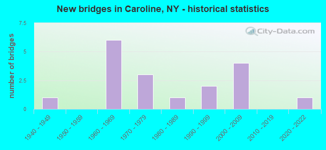
- New bridges - historical statistics
- 11940-1949
- 61960-1969
- 31970-1979
- 11980-1989
- 21990-1999
- 42000-2009
- 12020-2022

- Reconstructed bridges - Historical Statistics
- 11980-1989
- 01990-1999
- 12000-2009


- Bridge Condition - Deck
- 8.3%Excellent
- 33.3%Very good
- 16.7%Good
- 33.3%Satisfactory
- 8.3%Fair

- Bridge Condition - Superstructure
- 8.3%Excellent
- 25.0%Very good
- 41.7%Good
- 16.7%Satisfactory
- 8.3%Fair

- Bridge Condition - Substructure
- 25.0%Very good
- 33.3%Good
- 16.7%Satisfactory
- 25.0%Fair

- Bridge Condition - Channel
- 22.2%Good
- 27.8%Satisfactory
- 33.3%Fair
- 16.7%Poor

- Bridge Condition - Culverts
- 16.7%Very good
- 50.0%Good
- 16.7%Fair
- 16.7%Poor
Find on map >> Show street view
Structure Number: 103059, Location: 3.6 MI NW TIOGA CL;RTE 79 (Lat: 42.393056, Lng: -76.343092), Route carried "on" structure: State highway 79, Year Built: 1963, Status: Open, Structure Length: 1.10m (3.61ft), Average Daily Traffic: 3,546 (year 2020), Truck Traffic: 9%, Average Future Daily Traffic: 3,666 (year 2040), Design Load: HS 20, Features Intersected: SIX MILE CREEK
Minimum Vertical Clearance: 30+ m (98+ ft), Kilometerpoint: 5.744, Lanes on structure: 2, Base Highway Network: Yes, Owner: State Highway Agency, Approaching Roadway Width: 11.3m (37.1ft), Skew: 2 degrees, Material/Design: Concrete continuous, Design/Construction: Frame, Number Of Spans In Main Unit: 2, Length of Maximum Span: 4.5m (14.8ft), Curb-To-Curb Width: 13.4m (44.0ft), Out-to-Out Width: 14.2m (46.6ft)
Condition: Deck: Satisfactory, Superstructure: Satisfactory, Substructure: Satisfactory, Channel: Satisfactory, Operating Rating: 75.8 metric tons, Method Used To Determine Operating Rating: Field evaluation and documented engineering judgment, Inventory Rating: 32.7 metric tons, Method Used To Determine Inventory Rating: Field evaluation and documented engineering judgment, Structural Evaluation: Equal to present minimum criteria, Deck Geometry: Better than present minimum criteria, Waterway Adequacy: Somewhat better than minimum adequacy, Approach Roadway Alignment: Equal to present desirable criteria, Length Of Structure Improvement: 1.09m (3.58ft), Designated Inspection Frequency: Every 24 months, Inspection Date: December 2021, Bridge Improvement Cost: $661,000, Roadway Improvement Cost: $387,000, Total Project Cost: $1,048,000 ( Estimate for 2021), Wearing Surface/Protective System: Wearing Surface: Bituminous
Find on map >> Show street view
Structure Number: 104599, Location: AT BROOKTONDALE (Lat: 42.381461, Lng: -76.396642), Route carried "on" structure: County highway , Year Built: 1966, Status: Open, Structure Length: 2.13m (6.99ft), Average Daily Traffic: 1,060 (year 2020), Truck Traffic: 5%, Average Future Daily Traffic: 1,481 (year 2040), Design Load: HS 20, Features Intersected: SIX MILE CREEK, Facility Carried by Structure: COOKS CORS-BRK RD
Minimum Vertical Clearance: 30+ m (98+ ft), Kilometerpoint: 17.232, Lanes on structure: 2, Owner: County Highway Agency, Approaching Roadway Width: 7.6m (24.9ft), Skew: 5 degrees, Material/Design: Concrete continuous, Design/Construction: Culvert, Number Of Spans In Main Unit: 2, Length of Maximum Span: 6.4m (21.0ft), Curb-To-Curb Width: 9.8m (32.2ft), Out-to-Out Width: 27.4m (89.9ft)
Condition: Channel: Satisfactory, Culverts: Fair, Operating Rating: 76.7 metric tons, Method Used To Determine Operating Rating: Field evaluation and documented engineering judgment, Inventory Rating: 29.4 metric tons, Method Used To Determine Inventory Rating: Field evaluation and documented engineering judgment, Structural Evaluation: Somewhat better than minimum adequacy, Deck Geometry: Somewhat better than minimum adequacy, Waterway Adequacy: Meets minimum limits, Approach Roadway Alignment: Equal to present desirable criteria, Length Of Structure Improvement: 2.13m (6.99ft), Designated Inspection Frequency: Every 24 months, Inspection Date: June 2020, Bridge Improvement Cost: $2,188,000, Roadway Improvement Cost: $1,281,000, Total Project Cost: $3,469,000 ( Estimate for 2021), Wearing Surface/Protective System: Wearing Surface: Bituminous
Find on map >> Show street view
Structure Number: 1046, Location: .5 MI S OF WEST SLATERVLE (Lat: 42.386169, Lng: -76.364808), Route carried "on" structure: County highway , Year Built: 1966, Status: Open, Structure Length: 1.01m (3.31ft), Average Daily Traffic: 658 (year 2018), Truck Traffic: 10%, Average Future Daily Traffic: 921 (year 2038), Design Load: HS 20, Features Intersected: BOICE CREEK, Facility Carried by Structure: VALLEY ROAD
Minimum Vertical Clearance: 30+ m (98+ ft), Kilometerpoint: 14.368, Lanes on structure: 2, Owner: County Highway Agency, Approaching Roadway Width: 6.4m (21.0ft), Skew: 3 degrees, Material/Design: Concrete continuous, Design/Construction: Culvert, Number Of Spans In Main Unit: 2, Length of Maximum Span: 3.9m (12.8ft), Curb-To-Curb Width: 9.7m (31.8ft), Out-to-Out Width: 10.6m (34.8ft)
Condition: Channel: Poor, Culverts: Good, Operating Rating: 75.4 metric tons, Method Used To Determine Operating Rating: Field evaluation and documented engineering judgment, Inventory Rating: 32.7 metric tons, Method Used To Determine Inventory Rating: Field evaluation and documented engineering judgment, Structural Evaluation: Better than present minimum criteria, Deck Geometry: Equal to present minimum criteria, Waterway Adequacy: Meets minimum limits, Approach Roadway Alignment: Equal to present desirable criteria, Length Of Structure Improvement: 1.00m (3.28ft), Designated Inspection Frequency: Every 24 months, Inspection Date: April 2021, Bridge Improvement Cost: $466,000, Roadway Improvement Cost: $273,000, Total Project Cost: $740,000 ( Estimate for 2021)
Find on map >> Show street view
Structure Number: 104601, Location: 1 MI SE OF W.SLATERVILLE (Lat: 42.379528, Lng: -76.355339), Route carried "on" structure: County highway , Year Built: 1966, Status: Open, Structure Length: 1.04m (3.41ft), Average Daily Traffic: 1,050 (year 2016), Truck Traffic: 5%, Average Future Daily Traffic: 1,470 (year 2036), Design Load: HS 20, Features Intersected: BOICE CREEK, Facility Carried by Structure: CENTRAL CHAPEL RD
Minimum Vertical Clearance: 30+ m (98+ ft), Kilometerpoint: 13.290, Lanes on structure: 2, Owner: County Highway Agency, Approaching Roadway Width: 6.4m (21.0ft), Skew: 3 degrees, Material/Design: Concrete continuous, Design/Construction: Culvert, Number Of Spans In Main Unit: 2, Length of Maximum Span: 3.9m (12.8ft), Curb-To-Curb Width: 9.8m (32.2ft), Out-to-Out Width: 10.8m (35.4ft)
Condition: Channel: Fair, Culverts: Good, Operating Rating: 75.1 metric tons, Method Used To Determine Operating Rating: Field evaluation and documented engineering judgment, Inventory Rating: 29.4 metric tons, Method Used To Determine Inventory Rating: Field evaluation and documented engineering judgment, Structural Evaluation: Better than present minimum criteria, Deck Geometry: Somewhat better than minimum adequacy, Waterway Adequacy: Meets minimum limits, Approach Roadway Alignment: Equal to present desirable criteria, Length Of Structure Improvement: 1.03m (3.38ft), Designated Inspection Frequency: Every 24 months, Inspection Date: April 2021, Bridge Improvement Cost: $443,000, Roadway Improvement Cost: $259,000, Total Project Cost: $702,000 ( Estimate for 2021)
Find on map >> Show street view
Structure Number: 104602, Location: 4.9 MI SE JCT RTS. 330&79 (Lat: 42.375519, Lng: -76.353633), Route carried "on" structure: County highway , Year Built: 2021, Status: Open, Structure Length: 1.22m (4.00ft), Average Daily Traffic: 990 (year 2016), Truck Traffic: 5%, Average Future Daily Traffic: 1,386 (year 2036), Features Intersected: BOICE CREEK, Facility Carried by Structure: CENTRAL CHAPEL RD
Minimum Vertical Clearance: 32.69m (107.25ft), Kilometerpoint: 12.824, Lanes on structure: 2, Owner: County Highway Agency, Approaching Roadway Width: 8.5m (27.9ft), Skew: 3 degrees, Material/Design: Concrete, Design/Construction: Frame, Number Of Spans In Main Unit: 1, Length of Maximum Span: 12.2m (40.0ft), Curb-To-Curb Width: 8.5m (27.9ft), Out-to-Out Width: 9.5m (31.2ft)
Condition: Deck: Excellent, Superstructure: Excellent, Substructure: Good, Channel: Fair, Operating Rating: 81.3 metric tons, Method Used To Determine Operating Rating: Field evaluation and documented engineering judgment, Inventory Rating: 40.8 metric tons, Method Used To Determine Inventory Rating: Field evaluation and documented engineering judgment, Structural Evaluation: Better than present minimum criteria, Deck Geometry: Somewhat better than minimum adequacy, Waterway Adequacy: Better than present minimum criteria, Approach Roadway Alignment: Equal to present desirable criteria, Designated Inspection Frequency: Every 24 months, Inspection Date: November 2021, Wearing Surface/Protective System: Wearing Surface: Bituminous, Membrane: Other
Find on map >> Show street view
Structure Number: 104603, Location: AT GUIDE BOARD CORNERS (Lat: 42.370703, Lng: -76.353258), Route carried "on" structure: County highway , Year Built: 1966, Status: Open, Structure Length: 0.70m (2.30ft), Average Daily Traffic: 959 (year 2016), Truck Traffic: 4%, Average Future Daily Traffic: 1,343 (year 2036), Design Load: HS 20, Features Intersected: BOICE CREEK, Facility Carried by Structure: CENTRAL CHAPEL RD
Minimum Vertical Clearance: 30+ m (98+ ft), Kilometerpoint: 12.293, Lanes on structure: 2, Owner: County Highway Agency, Approaching Roadway Width: 6.4m (21.0ft), Material/Design: Concrete, Design/Construction: Culvert, Number Of Spans In Main Unit: 1, Length of Maximum Span: 6.4m (21.0ft), Curb-To-Curb Width: 9.8m (32.2ft), Out-to-Out Width: 10.7m (35.1ft)
Condition: Channel: Poor, Culverts: Good, Operating Rating: 77.1 metric tons, Method Used To Determine Operating Rating: Field evaluation and documented engineering judgment, Inventory Rating: 32.7 metric tons, Method Used To Determine Inventory Rating: Field evaluation and documented engineering judgment, Structural Evaluation: Better than present minimum criteria, Deck Geometry: Equal to present minimum criteria, Waterway Adequacy: Meets minimum limits, Approach Roadway Alignment: Equal to present desirable criteria, Length Of Structure Improvement: 0.70m (2.30ft), Designated Inspection Frequency: Every 24 months, Inspection Date: April 2021, Bridge Improvement Cost: $325,000, Roadway Improvement Cost: $190,000, Total Project Cost: $515,000 ( Estimate for 2021)
Find on map >> Show street view
Structure Number: 10947, Location: .3 MI E JCT SH 79 & CR162 (Lat: 42.393814, Lng: -76.355647), Route carried "on" structure: State highway 79, Year Built: 1963, Status: Open, Structure Length: 0.76m (2.49ft), Average Daily Traffic: 3,796 (year 2020), Truck Traffic: 8%, Average Future Daily Traffic: 3,925 (year 2040), Design Load: HS 20, Features Intersected: TRIB SIX MILE CRK
Minimum Vertical Clearance: 30+ m (98+ ft), Kilometerpoint: 6.806, Lanes on structure: 2, Base Highway Network: Yes, Owner: State Highway Agency, Approaching Roadway Width: 12.2m (40.0ft), Skew: 4 degrees, Material/Design: Steel, Design/Construction: Culvert, Number Of Spans In Main Unit: 2, Length of Maximum Span: 2.9m (9.5ft)
Condition: Channel: Fair, Culverts: Very good, Operating Rating: 74.6 metric tons, Method Used To Determine Operating Rating: Field evaluation and documented engineering judgment, Inventory Rating: 32.7 metric tons, Method Used To Determine Inventory Rating: Field evaluation and documented engineering judgment, Structural Evaluation: Equal to present desirable criteria, Waterway Adequacy: Somewhat better than minimum adequacy, Approach Roadway Alignment: Equal to present desirable criteria, Length Of Structure Improvement: 0.76m (2.49ft), Designated Inspection Frequency: Every 24 months, Inspection Date: April 2021, Bridge Improvement Cost: $215,000, Roadway Improvement Cost: $126,000, Total Project Cost: $341,000 ( Estimate for 2021)
Find on map >> Show street view
Structure Number: 320971, Location: 2 MI N OF SPEEDSVILLE (Lat: 42.330733, Lng: -76.246931), Route carried "on" structure: Other road , Year Built: 1994, Status: Open, Structure Length: 2.13m (6.99ft), Average Daily Traffic: 115 (year 2017), Truck Traffic: 8%, Average Future Daily Traffic: 161 (year 2037), Design Load: HS 25 or greater, Features Intersected: W BR OWEGO CREEK, Facility Carried by Structure: Blackman Hill Rd.
Minimum Vertical Clearance: 30+ m (98+ ft), Kilometerpoint: 0.000, Lanes on structure: 2, Owner: County Highway Agency, Approaching Roadway Width: 5.5m (18.0ft), Skew: 1 degrees, Material/Design: Steel, Design/Construction: Stringer/Multi-beam, Number Of Spans In Main Unit: 1, Length of Maximum Span: 19.8m (65.0ft), Curb-To-Curb Width: 7.3m (24.0ft), Out-to-Out Width: 7.9m (25.9ft)
Condition: Deck: Good, Superstructure: Good, Substructure: Good, Channel: Satisfactory, Inventory Rating: 65.3 metric tons, Method Used To Determine Inventory Rating: Load Factor (LF), Structural Evaluation: Better than present minimum criteria, Deck Geometry: Somewhat better than minimum adequacy, Waterway Adequacy: Somewhat better than minimum adequacy, Approach Roadway Alignment: Equal to present desirable criteria, Length Of Structure Improvement: 2.13m (6.99ft), Designated Inspection Frequency: Every 24 months, Inspection Date: September 2020, Bridge Improvement Cost: $378,000, Roadway Improvement Cost: $221,000, Total Project Cost: $599,000 ( Estimate for 2021), Deck Structure Type: Concrete Cast-file-Place, Wearing Surface/Protective System: Wearing Surface: Integral Concrete, Deck Protection: Epoxy Coated Reinforcing
Find on map >> Show street view
Structure Number: 320972, Location: 1 MI SOUTH OF BESEMER (Lat: 42.388914, Lng: -76.413539), Route carried "on" structure: Other road , Year Built: 1978, Status: Open, Structure Length: 2.53m (8.30ft), Average Daily Traffic: 656 (year 2016), Truck Traffic: 4%, Average Future Daily Traffic: 918 (year 2036), Design Load: HS 20, Features Intersected: SIXMILE CREEK, Facility Carried by Structure: MIDDAUGH ROAD
Minimum Vertical Clearance: 30+ m (98+ ft), Kilometerpoint: 1.947, Lanes on structure: 2, Owner: County Highway Agency, Approaching Roadway Width: 6.4m (21.0ft), Skew: 3 degrees, Material/Design: Steel, Design/Construction: Stringer/Multi-beam, Number Of Spans In Main Unit: 1, Length of Maximum Span: 25.0m (82.0ft), Curb-To-Curb Width: 6.9m (22.6ft), Out-to-Out Width: 7.9m (25.9ft)
Condition: Deck: Very good, Superstructure: Fair, Substructure: Fair, Channel: Satisfactory, Operating Rating: 33.0 metric tons, Method Used To Determine Operating Rating: Load and Resistance Factor Rating (LRFR) rating reported by rating factor(RF) method using HL-93 loadings, Inventory Rating: 25.6 metric tons, Method Used To Determine Inventory Rating: Load and Resistance Factor Rating (LRFR) rating reported by rating factor(RF) method using HL-93 loadings, Structural Evaluation: Somewhat better than minimum adequacy, Deck Geometry: Meets minimum limits, Waterway Adequacy: Meets minimum limits, Approach Roadway Alignment: Equal to present minimum criteria, Length Of Structure Improvement: 2.52m (8.27ft), Designated Inspection Frequency: Every 24 months, Inspection Date: April 2021, Bridge Improvement Cost: $480,000, Roadway Improvement Cost: $281,000, Total Project Cost: $761,000 ( Estimate for 2021), Deck Structure Type: Concrete Cast-file-Place, Wearing Surface/Protective System: Wearing Surface: Bituminous, Membrane: Other
Find on map >> Show street view
Structure Number: 320973, Location: .5 MILE EAST OF BESEMER (Lat: 42.395714, Lng: -76.421069), Route carried "on" structure: County highway , Year Built: 2008, Status: Open, Structure Length: 3.14m (10.30ft), Average Daily Traffic: 378 (year 2017), Truck Traffic: 8%, Average Future Daily Traffic: 529 (year 2037), Design Load: HL 93, Features Intersected: SIXMILE CREEK, Facility Carried by Structure: BANKS ROAD
Minimum Vertical Clearance: 30+ m (98+ ft), Kilometerpoint: 0.048, Lanes on structure: 2, Owner: County Highway Agency, Approaching Roadway Width: 9.4m (30.8ft), Skew: 2 degrees, Material/Design: Prestressed concrete, Design/Construction: Box Beam or Girders - Multiple, Number Of Spans In Main Unit: 1, Length of Maximum Span: 30.5m (100.1ft), Curb-To-Curb Width: 9.3m (30.5ft), Out-to-Out Width: 10.1m (33.1ft)
Condition: Deck: Very good, Superstructure: Good, Substructure: Very good, Channel: Good, Operating Rating: 97.1 metric tons, Method Used To Determine Operating Rating: Load Factor (LF), Inventory Rating: 47.2 metric tons, Method Used To Determine Inventory Rating: Load Factor (LF), Structural Evaluation: Better than present minimum criteria, Deck Geometry: Equal to present minimum criteria, Waterway Adequacy: Equal to present minimum criteria, Approach Roadway Alignment: Equal to present desirable criteria, Length Of Structure Improvement: 3.13m (10.27ft), Designated Inspection Frequency: Every 24 months, Inspection Date: October 2020, Bridge Improvement Cost: $886,000, Roadway Improvement Cost: $519,000, Total Project Cost: $1,405,000 ( Estimate for 2021), Deck Structure Type: Concrete Cast-file-Place, Wearing Surface/Protective System: Wearing Surface: Integral Concrete, Deck Protection: Epoxy Coated Reinforcing
Find on map >> Show street view
Structure Number: 320974, Location: .4 MI W SLATERVILLE SPGS. (Lat: 42.392508, Lng: -76.350508), Route carried "on" structure: Other road , Year Built: 1977, Status: Open, Structure Length: 1.22m (4.00ft), Average Daily Traffic: 244 (year 2016), Truck Traffic: 8%, Average Future Daily Traffic: 342 (year 2036), Design Load: H 20, Features Intersected: SIXMILE CREEK, Facility Carried by Structure: CREAMERY ROAD
Minimum Vertical Clearance: 30+ m (98+ ft), Kilometerpoint: 1.786, Lanes on structure: 2, Owner: County Highway Agency, Approaching Roadway Width: 5.8m (19.0ft), Material/Design: Steel, Design/Construction: Stringer/Multi-beam, Number Of Spans In Main Unit: 1, Length of Maximum Span: 11.5m (37.7ft), Curb-To-Curb Width: 7.3m (24.0ft), Out-to-Out Width: 7.9m (25.9ft)
Condition: Deck: Satisfactory, Superstructure: Good, Substructure: Fair, Channel: Satisfactory, Operating Rating: 25.9 metric tons, Method Used To Determine Operating Rating: Load and Resistance Factor Rating (LRFR) rating reported by rating factor(RF) method using HL-93 loadings, Inventory Rating: 20.1 metric tons, Method Used To Determine Inventory Rating: Load and Resistance Factor Rating (LRFR) rating reported by rating factor(RF) method using HL-93 loadings, Structural Evaluation: Somewhat better than minimum adequacy, Deck Geometry: Somewhat better than minimum adequacy, Waterway Adequacy: Somewhat better than minimum adequacy, Approach Roadway Alignment: Equal to present minimum criteria, Length Of Structure Improvement: 1.21m (3.97ft), Designated Inspection Frequency: Every 24 months, Inspection Date: April 2021, Bridge Improvement Cost: $341,000, Roadway Improvement Cost: $200,000, Total Project Cost: $540,000 ( Estimate for 2021), Deck Structure Type: Concrete Cast-file-Place, Wearing Surface/Protective System: Wearing Surface: Bituminous, Deck Protection: Epoxy Coated Reinforcing
Find on map >> Show street view
Structure Number: 320976, Location: IN SLATERVILLE SPRINGS (Lat: 42.393389, Lng: -76.345031), Route carried "on" structure: Other road , Year Built: 1993, Status: Open, Structure Length: 1.86m (6.10ft), Average Daily Traffic: 508 (year 2016), Truck Traffic: 4%, Average Future Daily Traffic: 711 (year 2036), Design Load: HS 25 or greater, Features Intersected: SIXMILE CREEK, Facility Carried by Structure: BUFFALO ROAD
Minimum Vertical Clearance: 30+ m (98+ ft), Kilometerpoint: 5.503, Lanes on structure: 2, Owner: County Highway Agency, Approaching Roadway Width: 9.1m (29.9ft), Skew: 3 degrees, Material/Design: Prestressed concrete, Design/Construction: Box Beam or Girders - Multiple, Number Of Spans In Main Unit: 1, Length of Maximum Span: 17.9m (58.7ft), Curb-To-Curb Width: 9.2m (30.2ft), Out-to-Out Width: 9.8m (32.2ft)
Condition: Deck: Very good, Superstructure: Very good, Substructure: Very good, Channel: Good, Operating Rating: 71.7 metric tons, Method Used To Determine Operating Rating: Load Factor (LF), Inventory Rating: 41.7 metric tons, Method Used To Determine Inventory Rating: Load Factor (LF), Structural Evaluation: Equal to present desirable criteria, Deck Geometry: Equal to present minimum criteria, Waterway Adequacy: Somewhat better than minimum adequacy, Approach Roadway Alignment: Equal to present desirable criteria, Length Of Structure Improvement: 1.85m (6.07ft), Designated Inspection Frequency: Every 24 months, Inspection Date: April 2021, Bridge Improvement Cost: $977,000, Roadway Improvement Cost: $572,000, Total Project Cost: $1,549,000 ( Estimate for 2021), Wearing Surface/Protective System: Wearing Surface: Bituminous, Membrane: Other
Find on map >> Show street view
Structure Number: 331404, Location: .9 MI W SLATERVILLE SPNGS (Lat: 42.393411, Lng: -76.362814), Route carried "on" structure: County highway , Year Built: 1942, Year Reconstructed: 1988, Status: Open, Structure Length: 1.25m (4.10ft), Average Daily Traffic: 1,047 (year 2018), Truck Traffic: 6%, Average Future Daily Traffic: 1,466 (year 2038), Features Intersected: SIXMILE CREEK, Facility Carried by Structure: BOICEVILLE ROAD
Minimum Vertical Clearance: 30+ m (98+ ft), Kilometerpoint: 0.885, Lanes on structure: 2, Owner: County Highway Agency, Approaching Roadway Width: 5.8m (19.0ft), Material/Design: Steel, Design/Construction: Stringer/Multi-beam, Number Of Spans In Main Unit: 1, Length of Maximum Span: 11.5m (37.7ft), Curb-To-Curb Width: 8.0m (26.2ft), Out-to-Out Width: 8.8m (28.9ft)
Condition: Deck: Fair, Superstructure: Satisfactory, Substructure: Fair, Channel: Fair, Operating Rating: 50.8 metric tons, Method Used To Determine Operating Rating: Load Factor (LF), Inventory Rating: 29.9 metric tons, Method Used To Determine Inventory Rating: Load Factor (LF), Structural Evaluation: Somewhat better than minimum adequacy, Deck Geometry: Meets minimum limits, Waterway Adequacy: Meets minimum limits, Approach Roadway Alignment: Equal to present minimum criteria, Length Of Structure Improvement: 1.24m (4.07ft), Designated Inspection Frequency: Every 24 months, Inspection Date: July 2021, Bridge Improvement Cost: $307,000, Roadway Improvement Cost: $180,000, Total Project Cost: $487,000 ( Estimate for 2021), Deck Structure Type: Concrete Precast Panels, Wearing Surface/Protective System: Wearing Surface: Bituminous, Membrane: Other
Find on map >> Show street view
Structure Number: 331405, Location: .3 MILE S OF SPEEDSVILLE (Lat: 42.301256, Lng: -76.254519), Route carried "on" structure: County highway , Year Built: 2009, Status: Open, Structure Length: 1.04m (3.41ft), Average Daily Traffic: 363 (year 2020), Truck Traffic: 7%, Average Future Daily Traffic: 507 (year 2040), Design Load: HS 25 or greater, Features Intersected: BOYER CREEK, Facility Carried by Structure: OLD SEVNTY SIX RD
Minimum Vertical Clearance: 30+ m (98+ ft), Kilometerpoint: 0.499, Lanes on structure: 2, Owner: County Highway Agency, Approaching Roadway Width: 10.1m (33.1ft), Material/Design: Concrete, Design/Construction: Frame, Number Of Spans In Main Unit: 1, Length of Maximum Span: 9.8m (32.2ft), Curb-To-Curb Width: 10.1m (33.1ft), Out-to-Out Width: 11.1m (36.4ft)
Condition: Deck: Very good, Superstructure: Very good, Substructure: Very good, Channel: Fair, Inventory Rating: 67.1 metric tons, Method Used To Determine Inventory Rating: Load Factor (LF), Structural Evaluation: Equal to present desirable criteria, Deck Geometry: Better than present minimum criteria, Waterway Adequacy: Meets minimum limits, Approach Roadway Alignment: Equal to present desirable criteria, Length Of Structure Improvement: 1.03m (3.38ft), Designated Inspection Frequency: Every 24 months, Inspection Date: July 2021, Bridge Improvement Cost: $266,000, Roadway Improvement Cost: $156,000, Total Project Cost: $421,000 ( Estimate for 2021), Wearing Surface/Protective System: Wearing Surface: Bituminous, Membrane: Other
Find on map >> Show street view
Structure Number: 331406, Location: 1.5 MI NW OF SPEEDSVILLE (Lat: 42.318886, Lng: -76.275061), Route carried "on" structure: County highway , Year Built: 1987, Status: Open, Structure Length: 0.76m (2.49ft), Average Daily Traffic: 391 (year 2016), Truck Traffic: 8%, Average Future Daily Traffic: 547 (year 2036), Features Intersected: TRIB BOYER CREEK, Facility Carried by Structure: OLD SEVNTY SIX RD
Minimum Vertical Clearance: 30+ m (98+ ft), Kilometerpoint: 3.202, Lanes on structure: 2, Owner: County Highway Agency, Approaching Roadway Width: 6.4m (21.0ft), Material/Design: Aluminum, Iron, Design/Construction: Culvert, Number Of Spans In Main Unit: 1, Length of Maximum Span: 7.3m (24.0ft)
Condition: Channel: Fair, Culverts: Poor, Operating Rating: 75.7 metric tons, Method Used To Determine Operating Rating: Field evaluation and documented engineering judgment, Inventory Rating: 19.6 metric tons, Method Used To Determine Inventory Rating: Field evaluation and documented engineering judgment, Structural Evaluation: Meets minimum limits, Waterway Adequacy: Meets minimum limits, Approach Roadway Alignment: Equal to present desirable criteria, Length Of Structure Improvement: 0.76m (2.49ft), Designated Inspection Frequency: Every 24 months, Inspection Date: July 2021, Bridge Improvement Cost: $171,000, Roadway Improvement Cost: $100,000, Total Project Cost: $270,000 ( Estimate for 2021)
Find on map >> Show street view
Structure Number: 331408, Location: IN SPEEDSVILLE (Lat: 42.306656, Lng: -76.250331), Route carried "on" structure: County highway , Year Built: 2001, Status: Open, Structure Length: 2.04m (6.69ft), Average Daily Traffic: 419 (year 2015), Truck Traffic: 8%, Average Future Daily Traffic: 585 (year 2040), Design Load: HS 25 or greater, Features Intersected: W BR OWEGO CREEK, Facility Carried by Structure: OLD SEVNTY SIX RD
Minimum Vertical Clearance: 30+ m (98+ ft), Kilometerpoint: 0.000, Lanes on structure: 2, Owner: County Highway Agency, Approaching Roadway Width: 9.4m (30.8ft), Material/Design: Prestressed concrete, Design/Construction: Box Beam or Girders - Multiple, Number Of Spans In Main Unit: 1, Length of Maximum Span: 19.5m (64.0ft), Curb-To-Curb Width: 9.9m (32.5ft), Out-to-Out Width: 10.8m (35.4ft)
Condition: Deck: Satisfactory, Superstructure: Very good, Substructure: Satisfactory, Channel: Good, Inventory Rating: 68.9 metric tons, Method Used To Determine Inventory Rating: Load Factor (LF), Structural Evaluation: Equal to present minimum criteria, Deck Geometry: Equal to present minimum criteria, Waterway Adequacy: Equal to present minimum criteria, Approach Roadway Alignment: Equal to present desirable criteria, Length Of Structure Improvement: 2.04m (6.69ft), Designated Inspection Frequency: Every 24 months, Inspection Date: July 2021, Bridge Improvement Cost: $1,091,000, Roadway Improvement Cost: $639,000, Total Project Cost: $1,730,000 ( Estimate for 2021), Wearing Surface/Protective System: Wearing Surface: Epoxy Overlay
Find on map >> Show street view
Structure Number: 331409, Location: 2.8 MI W SLATERVLLE SPNGS (Lat: 42.393814, Lng: -76.297669), Route carried "on" structure: County highway , Year Built: 1977, Year Reconstructed: 2008, Status: Open, Structure Length: 1.19m (3.90ft), Average Daily Traffic: 575 (year 2019), Truck Traffic: 5%, Average Future Daily Traffic: 805 (year 2039), Design Load: HS 25 or greater, Features Intersected: W BR OWEGO CREEK, Facility Carried by Structure: HARFORD ROAD
Minimum Vertical Clearance: 30+ m (98+ ft), Kilometerpoint: 3.540, Lanes on structure: 2, Owner: County Highway Agency, Approaching Roadway Width: 8.2m (26.9ft), Skew: 3 degrees, Material/Design: Steel, Design/Construction: Stringer/Multi-beam, Number Of Spans In Main Unit: 1, Length of Maximum Span: 11.8m (38.7ft), Curb-To-Curb Width: 7.9m (25.9ft), Out-to-Out Width: 8.0m (26.2ft)
Condition: Deck: Good, Superstructure: Good, Substructure: Good, Channel: Poor, Operating Rating: 41.8 metric tons, Method Used To Determine Operating Rating: Load and Resistance Factor Rating (LRFR) rating reported by rating factor(RF) method using HL-93 loadings, Inventory Rating: 32.1 metric tons, Method Used To Determine Inventory Rating: Load and Resistance Factor Rating (LRFR) rating reported by rating factor(RF) method using HL-93 loadings, Structural Evaluation: Better than present minimum criteria, Deck Geometry: Somewhat better than minimum adequacy, Waterway Adequacy: Somewhat better than minimum adequacy, Approach Roadway Alignment: Equal to present desirable criteria, Length Of Structure Improvement: 1.18m (3.87ft), Designated Inspection Frequency: Every 24 months, Inspection Date: September 2020, Bridge Improvement Cost: $282,000, Roadway Improvement Cost: $165,000, Total Project Cost: $447,000 ( Estimate for 2021), Deck Structure Type: Corrugated Steel, Wearing Surface/Protective System: Wearing Surface: Bituminous, Membrane: Other
Find on map >> Show street view
Structure Number: 33141, Location: 1.6 MI SOUTH OF BESEMER (Lat: 42.381969, Lng: -76.388053), Route carried "on" structure: County highway , Year Built: 2003, Status: Open, Structure Length: 2.56m (8.40ft), Average Daily Traffic: 784 (year 2020), Truck Traffic: 7%, Average Future Daily Traffic: 1,096 (year 2040), Features Intersected: SIX MILE CREEK, Facility Carried by Structure: CR113LOUNSBERRYRD
Minimum Vertical Clearance: 30+ m (98+ ft), Kilometerpoint: 3.266, Lanes on structure: 2, Owner: County Highway Agency, Approaching Roadway Width: 9.4m (30.8ft), Material/Design: Prestressed concrete, Design/Construction: Box Beam or Girders - Multiple, Number Of Spans In Main Unit: 1, Length of Maximum Span: 24.0m (78.7ft), Curb or Sidewalk Widths: Left: 1.5m (4.9ft), Right: 0.0m, Curb-To-Curb Width: 9.5m (31.2ft), Out-to-Out Width: 11.9m (39.0ft)
Condition: Deck: Satisfactory, Superstructure: Good, Substructure: Good, Channel: Good, Operating Rating: 49.2 metric tons, Method Used To Determine Operating Rating: Load and Resistance Factor Rating (LRFR) rating reported by rating factor(RF) method using HL-93 loadings, Inventory Rating: 37.9 metric tons, Method Used To Determine Inventory Rating: Load and Resistance Factor Rating (LRFR) rating reported by rating factor(RF) method using HL-93 loadings, Structural Evaluation: Better than present minimum criteria, Deck Geometry: Equal to present minimum criteria, Waterway Adequacy: Equal to present minimum criteria, Approach Roadway Alignment: Meets minimum limits, Length Of Structure Improvement: 2.56m (8.40ft), Designated Inspection Frequency: Every 24 months, Inspection Date: June 2020, Bridge Improvement Cost: $1,299,000, Roadway Improvement Cost: $761,000, Total Project Cost: $2,059,000 ( Estimate for 2021), Deck Structure Type: Concrete Cast-file-Place, Wearing Surface/Protective System: Wearing Surface: Integral Concrete, Deck Protection: Epoxy Coated Reinforcing