Bridge Statistics for Castle Shannon, Pennsylvania (PA)
Condition, Traffic, Stress, Structural Evaluation, Project Costs
- National Bridge Inventory (NBI) Statistics
- 10Number of bridges
- 98ft / 29.9mTotal length
- $4,491,000Total costs
- 56,210Total average daily traffic
- 2,073Total average daily truck traffic
- 63,845Total future (year 2030) average daily traffic
- National Bridge Inventory (NBI) Registered Bridges for Castle Shannon
- No street view available for this location
- New bridges - historical statistics
- 11900-1909
- 11930-1939
- 11950-1959
- 41960-1969
- 11980-1989
- 11990-1999
- 12010-2019
- Reconstructed bridges - Historical Statistics
- 11920-1929
- 01930-1939
- 01940-1949
- 01950-1959
- 01960-1969
- 01970-1979
- 01980-1989
- 11990-1999
- 02000-2009
- 22010-2019
- Bridge Condition - Deck
- 16.7%Very good
- 50.0%Good
- 33.3%Satisfactory
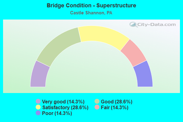
- Bridge Condition - Superstructure
- 14.3%Very good
- 28.6%Good
- 28.6%Satisfactory
- 14.3%Fair
- 14.3%Poor
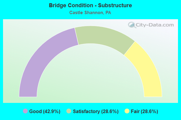
- Bridge Condition - Substructure
- 42.9%Good
- 28.6%Satisfactory
- 28.6%Fair
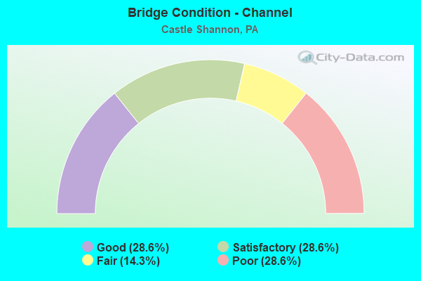
- Bridge Condition - Channel
- 28.6%Good
- 28.6%Satisfactory
- 14.3%Fair
- 28.6%Poor
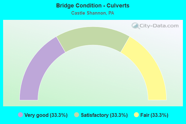
- Bridge Condition - Culverts
- 33.3%Very good
- 33.3%Satisfactory
- 33.3%Fair
Find on map >> Show street view
Structure Number: 439, Location: 2 N HEIDLERSBURG/BERMUDIA (Lat: 39.980281, Lng: -77.154614), Route carried "on" structure: City street , Year Built: 1963, Status: Open, Structure Length: 2.41m (7.91ft), Average Daily Traffic: 375 (year 2009), Truck Traffic: 5%, Average Future Daily Traffic: 525 (year 2030), Design Load: HS 20, Features Intersected: BERMUDIAN CREEK, Facility Carried by Structure: OXFORD ROAD
Minimum Vertical Clearance: 30+ m (98+ ft), Kilometerpoint: 0.000, Lanes on structure: 2, Owner: County Highway Agency, Approaching Roadway Width: 5.8m (19.0ft), Skew: 1 degrees, Material/Design: Prestressed concrete, Design/Construction: Box Beam or Girders - Multiple, Number Of Spans In Main Unit: 2, Length of Maximum Span: 11.0m (36.1ft), Curb or Sidewalk Widths: Left: 0.4m (1.3ft), Right: 0.4m (1.3ft), Curb-To-Curb Width: 8.5m (27.9ft), Out-to-Out Width: 10.2m (33.5ft)
Condition: Deck: Satisfactory, Superstructure: Satisfactory, Substructure: Good, Channel: Fair, Operating Rating: 62.6 metric tons, Method Used To Determine Operating Rating: Load and Resistance Factor (LRFR), Inventory Rating: 47.2 metric tons, Method Used To Determine Inventory Rating: Load and Resistance Factor (LRFR), Structural Evaluation: Equal to present minimum criteria, Deck Geometry: Equal to present minimum criteria, Waterway Adequacy: Better than present minimum criteria, Approach Roadway Alignment: Equal to present desirable criteria, Length Of Structure Improvement: 2.40m (7.87ft), Designated Inspection Frequency: Every 24 months, Inspection Date: July 2021, Deck Structure Type: Other, Wearing Surface/Protective System: Wearing Surface: Bituminous, Membrane: Preformed Fabric
Find on map >> Show street view
Structure Number: 1762, Location: 300' NW OF SR 88 (Lat: 40.365136, Lng: -80.023825), Route carried "on" structure: State highway , Year Built: 1900, Year Reconstructed: 1920, Status: Open, Structure Length: 0.70m (2.30ft), Average Daily Traffic: 12,242 (year 2021), Truck Traffic: 3%, Average Future Daily Traffic: 16,208 (year 2032), Design Load: HS 20, Features Intersected: SAW MILL RUN, Facility Carried by Structure: CASTLE SHANNON BLV
Minimum Vertical Clearance: 30+ m (98+ ft), Kilometerpoint: 1.920, Lanes on structure: 2, Base Highway Network: Yes, Owner: State Highway Agency, Approaching Roadway Width: 8.2m (26.9ft), Skew: 4 degrees, Material/Design: Masonry, Design/Construction: Arch - Deck, Number Of Spans In Main Unit: 1, Length of Maximum Span: 5.5m (18.0ft), Curb or Sidewalk Widths: Left: 2.4m (7.9ft), Right: 2.4m (7.9ft), Curb-To-Curb Width: 8.2m (26.9ft), Out-to-Out Width: 13.7m (44.9ft)
Condition: Superstructure: Fair, Substructure: Fair, Channel: Poor, Operating Rating: 72.6 metric tons, Method Used To Determine Operating Rating: Field evaluation and documented engineering judgment, Inventory Rating: 43.5 metric tons, Method Used To Determine Inventory Rating: Field evaluation and documented engineering judgment, Structural Evaluation: Somewhat better than minimum adequacy, Deck Geometry: High priority of replacement, Waterway Adequacy: Superior to present desirable criteria, Approach Roadway Alignment: Equal to present desirable criteria, Length Of Structure Improvement: 0.70m (2.30ft), Designated Inspection Frequency: Every 24 months, Inspection Date: March 2021, Bridge Improvement Cost: $5,000, Roadway Improvement Cost: $25,000, Total Project Cost: $71,000
Find on map >> Show street view
Structure Number: 1764, Location: 200'W.OF INTER.W/SR 0088 (Lat: 40.355753, Lng: -80.028692), Route carried "on" structure: State highway , Year Built: 1983, Status: Open, Structure Length: 3.41m (11.19ft), Average Daily Traffic: 15,011 (year 2022), Truck Traffic: 5%, Average Future Daily Traffic: 10,283 (year 2032), Design Load: HS 20, Features Intersected: PAT TROLLEY # 9830, Facility Carried by Structure: CONNOR RD
Minimum Vertical Clearance: 30+ m (98+ ft), Kilometerpoint: 2.292, Lanes on structure: 4, Base Highway Network: Yes, Owner: State Highway Agency, Approaching Roadway Width: 16.2m (53.1ft), Material/Design: Prestressed concrete, Design/Construction: Box Beam or Girders - Single/Spread, Number Of Spans In Main Unit: 2, Length of Maximum Span: 19.2m (63.0ft), Curb or Sidewalk Widths: Left: 1.5m (4.9ft), Right: 1.5m (4.9ft), Curb-To-Curb Width: 16.0m (52.5ft), Out-to-Out Width: 19.2m (63.0ft)
Condition: Deck: Satisfactory, Superstructure: Poor, Substructure: Fair, Operating Rating: 62.6 metric tons, Method Used To Determine Operating Rating: Load Factor (LF), Inventory Rating: 37.2 metric tons, Method Used To Determine Inventory Rating: Load Factor (LF), Structural Evaluation: Meets minimum limits, Deck Geometry: Meets minimum limits, Underclear: High priority of corrective action, Approach Roadway Alignment: Equal to present desirable criteria, Length Of Structure Improvement: 3.40m (11.15ft), Designated Inspection Frequency: Every 24 months, Inspection Date: November 2019, Bridge Improvement Cost: $21,000, Roadway Improvement Cost: $62,000, Total Project Cost: $284,000, Deck Structure Type: Concrete Cast-file-Place, Wearing Surface/Protective System: Wearing Surface: Epoxy Overlay
Find on map >> Show street view
Structure Number: 2569, Location: 416002 AT ROUTE 88 (Lat: 40.373997, Lng: -80.006661), Route carried "on" structure: City street , Year Built: 1955, Status: Open, Structure Length: 0.85m (2.79ft), Average Daily Traffic: 1,500 (year 2018), Truck Traffic: 5%, Average Future Daily Traffic: 1,750 (year 2039), Features Intersected: SAW MILL RUN, Facility Carried by Structure: KILLARNEY DR
Minimum Vertical Clearance: 30+ m (98+ ft), Kilometerpoint: 0.000, Lanes on structure: 2, Owner: City or Municipal Highway Agency, Approaching Roadway Width: 7.3m (24.0ft), Skew: 1 degrees, Material/Design: Concrete, Design/Construction: Culvert, Number Of Spans In Main Unit: 1, Length of Maximum Span: 7.9m (25.9ft), Curb or Sidewalk Widths: Left: 1.2m (3.9ft), Right: 0.3m (1.0ft)
Condition: Channel: Poor, Culverts: Fair, Operating Rating: 54.4 metric tons, Method Used To Determine Operating Rating: Field evaluation and documented engineering judgment, Inventory Rating: 32.7 metric tons, Method Used To Determine Inventory Rating: Field evaluation and documented engineering judgment, Structural Evaluation: Somewhat better than minimum adequacy, Waterway Adequacy: Better than present minimum criteria, Approach Roadway Alignment: Equal to present desirable criteria, Length Of Structure Improvement: 0.90m (2.95ft), Designated Inspection Frequency: Every 24 months, Inspection Date: July 2020, Bridge Improvement Cost: $5,000, Roadway Improvement Cost: $25,000, Total Project Cost: $62,000
Find on map >> Show street view
Structure Number: 8543, Location: .25 MI.E.OF EBENSBURG (Lat: 40.483383, Lng: -78.713642), Route carried "on" structure: State highway , Year Built: 1999, Status: Open, Structure Length: 0.61m (2.00ft), Average Daily Traffic: 2,079 (year 2020), Truck Traffic: 2%, Average Future Daily Traffic: 3,068 (year 2032), Design Load: HS 25 or greater, Features Intersected: HOWELLS RUN, Facility Carried by Structure: SR 1001
Minimum Vertical Clearance: 30+ m (98+ ft), Kilometerpoint: 0.000, Lanes on structure: 2, Owner: State Highway Agency, Approaching Roadway Width: 8.5m (27.9ft), Skew: 1 degrees, Material/Design: Concrete, Design/Construction: Culvert, Number Of Spans In Main Unit: 1, Length of Maximum Span: 6.1m (20.0ft), Curb-To-Curb Width: 10.2m (33.5ft), Out-to-Out Width: 11.4m (37.4ft)
Condition: Channel: Satisfactory, Culverts: Very good, Operating Rating: 73.5 metric tons, Method Used To Determine Operating Rating: Load Factor (LF), Inventory Rating: 43.5 metric tons, Method Used To Determine Inventory Rating: Load Factor (LF), Structural Evaluation: Equal to present desirable criteria, Deck Geometry: Meets minimum limits, Waterway Adequacy: Equal to present minimum criteria, Approach Roadway Alignment: Equal to present desirable criteria, Length Of Structure Improvement: 0.70m (2.30ft), Designated Inspection Frequency: Every 48 months, Inspection Date: September 2018, Wearing Surface/Protective System: Wearing Surface: Bituminous
Find on map >> Show street view
Structure Number: 8545, Location: 2 MI.E.OF EBENSBURG (Lat: 40.499600, Lng: -78.686797), Route carried "on" structure: State highway , Year Built: 1962, Year Reconstructed: 2010, Status: Open, Structure Length: 2.96m (9.71ft), Average Daily Traffic: 2,079 (year 2020), Truck Traffic: 2%, Average Future Daily Traffic: 3,068 (year 2032), Design Load: HS 20, Features Intersected: R. J. CORMAN RAILROAD, Facility Carried by Structure: SR 1001
Minimum Vertical Clearance: 30+ m (98+ ft), Kilometerpoint: 3.552, Lanes on structure: 2, Owner: State Highway Agency, Approaching Roadway Width: 9.4m (30.8ft), Skew: 3 degrees, Material/Design: Steel, Design/Construction: Stringer/Multi-beam, Number Of Spans In Main Unit: 1, Length of Maximum Span: 27.4m (89.9ft), Curb-To-Curb Width: 11.5m (37.7ft), Out-to-Out Width: 13.3m (43.6ft)
Condition: Deck: Good, Superstructure: Good, Substructure: Good, Operating Rating: 98.9 metric tons, Method Used To Determine Operating Rating: Load Factor (LF), Inventory Rating: 59.0 metric tons, Method Used To Determine Inventory Rating: Load Factor (LF), Structural Evaluation: Better than present minimum criteria, Deck Geometry: Somewhat better than minimum adequacy, Underclear: High priority of corrective action, Approach Roadway Alignment: Equal to present desirable criteria, Length Of Structure Improvement: 3.70m (12.14ft), Designated Inspection Frequency: Every 48 months, Inspection Date: July 2019, Bridge Improvement Cost: $89,000, Roadway Improvement Cost: $264,000, Total Project Cost: $1,200,000, Deck Structure Type: Concrete Cast-file-Place, Wearing Surface/Protective System: Wearing Surface: Latex Concrete
Find on map >> Show street view
Structure Number: 8619, Location: 0.01 MILE EAST OF PA 403 (Lat: 40.285856, Lng: -78.920064), Route carried "on" structure: State highway , Year Built: 1937, Year Reconstructed: 2010, Status: Open, Structure Length: 7.10m (23.29ft), Average Daily Traffic: 5,881 (year 2020), Truck Traffic: 3%, Average Future Daily Traffic: 8,985 (year 2032), Design Load: HS 20, Features Intersected: STONY CREEK RIVER, Facility Carried by Structure: SR 3006
Minimum Vertical Clearance: 30+ m (98+ ft), Kilometerpoint: 0.000, Lanes on structure: 2, Owner: State Highway Agency, Approaching Roadway Width: 7.3m (24.0ft), Material/Design: Steel, Design/Construction: Truss - Thru, Number Of Spans In Main Unit: 2, Length of Maximum Span: 34.4m (112.9ft), Curb or Sidewalk Widths: Left: 1.5m (4.9ft), Right: 0.0m, Curb-To-Curb Width: 7.3m (24.0ft), Out-to-Out Width: 7.9m (25.9ft)
Condition: Deck: Good, Superstructure: Satisfactory, Substructure: Satisfactory, Channel: Satisfactory, Operating Rating: 59.0 metric tons, Method Used To Determine Operating Rating: Load Factor (LF), Inventory Rating: 35.4 metric tons, Method Used To Determine Inventory Rating: Load Factor (LF), Structural Evaluation: Equal to present minimum criteria, Deck Geometry: High priority of replacement, Waterway Adequacy: Better than present minimum criteria, Approach Roadway Alignment: Equal to present desirable criteria, Length Of Structure Improvement: 8.80m (28.87ft), Designated Inspection Frequency: Every 24 months, Critical Feature Inspection Frequency: Every 24 months, Underwater Inspection Frequency: Every 60 months, Inspection Date: October 2020, Critical Feature Inspection Date: October 2020, Underwater Inspection Date: October 2021, Bridge Improvement Cost: $213,000, Roadway Improvement Cost: $627,000, Total Project Cost: $2,874,000, Deck Structure Type: Concrete Cast-file-Place, Wearing Surface/Protective System: Wearing Surface: Monolithic Concrete, Deck Protection: Galvanized Reinforcing
Find on map >> Show street view
Structure Number: 8623, Location: 2.25 MI.E.OF KRING (Lat: 40.261581, Lng: -78.875492), Route carried "on" structure: State highway , Year Built: 1969, Year Reconstructed: 1999, Status: Open, Structure Length: 8.23m (27.00ft), Average Daily Traffic: 7,085 (year 2022), Truck Traffic: 4%, Average Future Daily Traffic: 9,035 (year 2032), Design Load: HS 25 or greater, Features Intersected: US 219, Facility Carried by Structure: SR 3006
Minimum Vertical Clearance: 30+ m (98+ ft), Kilometerpoint: 5.969, Lanes on structure: 2, Lanes under structure: 4, Owner: State Highway Agency, Approaching Roadway Width: 9.1m (29.9ft), Skew: 4 degrees, Material/Design: Prestressed concrete, Design/Construction: Box Beam or Girders - Single/Spread, Number Of Spans In Main Unit: 4, Length of Maximum Span: 22.6m (74.1ft), Curb or Sidewalk Widths: Left: 0.2m (0.7ft), Right: 0.2m (0.7ft), Curb-To-Curb Width: 9.9m (32.5ft), Out-to-Out Width: 10.8m (35.4ft)
Condition: Deck: Good, Superstructure: Good, Substructure: Good, Operating Rating: 65.3 metric tons, Method Used To Determine Operating Rating: Load Factor (LF), Inventory Rating: 41.7 metric tons, Method Used To Determine Inventory Rating: Load Factor (LF), Structural Evaluation: Better than present minimum criteria, Deck Geometry: Meets minimum limits, Underclear: Equal to present minimum criteria, Approach Roadway Alignment: Better than present minimum criteria, Length Of Structure Improvement: 9.20m (30.18ft), Designated Inspection Frequency: Every 48 months, Inspection Date: March 2019, Deck Structure Type: Concrete Cast-file-Place, Wearing Surface/Protective System: Wearing Surface: Monolithic Concrete, Deck Protection: Epoxy Coated Reinforcing
Find on map >> Show street view
Structure Number: 13233, Location: UNION TOWNSHIP (Lat: 41.545942, Lng: -80.112494), Route carried "on" structure: State highway , Year Built: 1962, Year Reconstructed: 2021, Status: Open, Structure Length: 2.87m (9.42ft), Average Daily Traffic: 827 (year 2021), Truck Traffic: 6%, Average Future Daily Traffic: 923 (year 2032), Design Load: HS 20, Features Intersected: OVER CONNEAUT CREEK, Facility Carried by Structure: SR 2005,SHAWS LAND
Minimum Vertical Clearance: 30+ m (98+ ft), Kilometerpoint: 6.260, Lanes on structure: 2, Owner: State Highway Agency, Approaching Roadway Width: 7.0m (23.0ft), Material/Design: Prestressed concrete, Design/Construction: Box Beam or Girders - Multiple, Number Of Spans In Main Unit: 1, Length of Maximum Span: 28.0m (91.9ft), Curb or Sidewalk Widths: Left: 0.5m (1.6ft), Right: 0.5m (1.6ft), Curb-To-Curb Width: 8.5m (27.9ft), Out-to-Out Width: 10.2m (33.5ft)
Condition: Deck: Very good, Superstructure: Very good, Substructure: Satisfactory, Channel: Good, Operating Rating: 89.8 metric tons, Method Used To Determine Operating Rating: Load Factor (LF), Inventory Rating: 40.8 metric tons, Method Used To Determine Inventory Rating: Load Factor (LF), Structural Evaluation: Equal to present minimum criteria, Deck Geometry: Somewhat better than minimum adequacy, Waterway Adequacy: Equal to present desirable criteria, Approach Roadway Alignment: Equal to present desirable criteria, Length Of Structure Improvement: 3.60m (11.81ft), Designated Inspection Frequency: Every 24 months, Underwater Inspection Frequency: Every 60 months, Inspection Date: May 2020, Underwater Inspection Date: November 2021, Deck Structure Type: Concrete Cast-file-Place, Wearing Surface/Protective System: Wearing Surface: Bituminous, Membrane: Preformed Fabric, Deck Protection: Epoxy Coated Reinforcing
Find on map >> Show street view
Structure Number: 46063, Location: Grove Rd & Rt 88 (Lat: 40.366944, Lng: -80.014733), Route carried "on" structure: ServiceCity street , Year Built: 2010, Status: Open, Structure Length: 0.79m (2.59ft), Average Daily Traffic: 9,131 (year 2018), Truck Traffic: 3%, Average Future Daily Traffic: 10,000 (year 2039), Design Load: HL 93, Features Intersected: Saw Mill Run, Facility Carried by Structure: Grove Rd
Minimum Vertical Clearance: 30+ m (98+ ft), Kilometerpoint: 0.000, Lanes on structure: 2, Owner: Town or Township Highway Agency, Approaching Roadway Width: 7.0m (23.0ft), Skew: 1 degrees, Material/Design: Concrete, Design/Construction: Culvert, Number Of Spans In Main Unit: 1, Length of Maximum Span: 7.6m (24.9ft), Curb or Sidewalk Widths: Left: 1.4m (4.6ft), Right: 0.2m (0.7ft)
Condition: Channel: Good, Culverts: Satisfactory, Operating Rating: 94.3 metric tons, Method Used To Determine Operating Rating: Load Factor (LF), Inventory Rating: 44.5 metric tons, Method Used To Determine Inventory Rating: Load Factor (LF), Structural Evaluation: Equal to present minimum criteria, Waterway Adequacy: Better than present minimum criteria, Approach Roadway Alignment: Equal to present desirable criteria, Designated Inspection Frequency: Every 24 months, Inspection Date: July 2020