Bridge Statistics for Catlin, New York (NY)
Condition, Traffic, Stress, Structural Evaluation, Project Costs
- National Bridge Inventory (NBI) Statistics
- 17Number of bridges
- 79ft / 24.3mTotal length
- $13,072,000Total costs
- 24,611Total average daily traffic
- 2,292Total average daily truck traffic
- 26,204Total future (year 2040) average daily traffic
- National Bridge Inventory (NBI) Registered Bridges for Catlin
- No street view available for this location
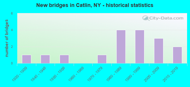
- New bridges - historical statistics
- 11930-1939
- 11940-1949
- 11950-1959
- 11970-1979
- 41980-1989
- 41990-1999
- 32000-2009
- 22010-2019

- Reconstructed bridges - Historical Statistics
- 21990-1999
- 22000-2009


- Bridge Condition - Deck
- 27.3%Excellent
- 18.2%Very good
- 54.5%Good

- Bridge Condition - Superstructure
- 41.7%Excellent
- 41.7%Very good
- 8.3%Good
- 8.3%Satisfactory

- Bridge Condition - Substructure
- 16.7%Excellent
- 33.3%Very good
- 25.0%Good
- 8.3%Satisfactory
- 16.7%Fair

- Bridge Condition - Channel
- 18.8%Very good
- 12.5%Good
- 31.3%Satisfactory
- 31.3%Fair
- 6.3%Poor

- Bridge Condition - Culverts
- 20.0%Very good
- 40.0%Good
- 20.0%Satisfactory
- 20.0%Fair
Find on map >> Show street view
Structure Number: 104802, Location: .2 MI NE SR 414 & CO LINE (Lat: 42.229031, Lng: -76.963836), Route carried "on" structure: State highway 414, Year Built: 2004, Status: Open, Structure Length: 5.12m (16.80ft), Average Daily Traffic: 4,387 (year 2020), Truck Traffic: 11%, Average Future Daily Traffic: 4,414 (year 2040), Design Load: HS 25 or greater, Features Intersected: NORFOLK SOUTHERN
Minimum Vertical Clearance: 30+ m (98+ ft), Kilometerpoint: 0.161, Lanes on structure: 2, Base Highway Network: Yes, Owner: State Highway Agency, Approaching Roadway Width: 11.9m (39.0ft), Skew: 5 degrees, Material/Design: Steel, Design/Construction: Stringer/Multi-beam, Number Of Spans In Main Unit: 1, Length of Maximum Span: 49.0m (160.8ft), Curb-To-Curb Width: 12.0m (39.4ft), Out-to-Out Width: 12.9m (42.3ft)
Condition: Deck: Good, Superstructure: Very good, Substructure: Good, Operating Rating: 68.0 metric tons, Method Used To Determine Operating Rating: Load Factor (LF), Inventory Rating: 40.8 metric tons, Method Used To Determine Inventory Rating: Load Factor (LF), Structural Evaluation: Better than present minimum criteria, Deck Geometry: Somewhat better than minimum adequacy, Underclear: Superior to present desirable criteria, Approach Roadway Alignment: Equal to present desirable criteria, Length Of Structure Improvement: 5.12m (16.80ft), Designated Inspection Frequency: Every 24 months, Inspection Date: June 2020, Bridge Improvement Cost: $1,811,000, Roadway Improvement Cost: $1,060,000, Total Project Cost: $2,871,000 ( Estimate for 2021), Deck Structure Type: Concrete Cast-file-Place, Wearing Surface/Protective System: Wearing Surface: Integral Concrete, Deck Protection: Epoxy Coated Reinforcing
Find on map >> Show street view
Structure Number: 104803, Location: 0.3 MI NE SR414+ CO LINE (Lat: 42.230231, Lng: -76.962264), Route carried "on" structure: State highway 414, Year Built: 2004, Status: Open, Structure Length: 4.66m (15.29ft), Average Daily Traffic: 4,387 (year 2020), Truck Traffic: 11%, Average Future Daily Traffic: 4,414 (year 2040), Design Load: HS 25 or greater, Features Intersected: POST CREEK
Minimum Vertical Clearance: 30+ m (98+ ft), Kilometerpoint: 0.354, Lanes on structure: 2, Base Highway Network: Yes, Owner: State Highway Agency, Approaching Roadway Width: 11.9m (39.0ft), Skew: 4 degrees, Material/Design: Steel, Design/Construction: Stringer/Multi-beam, Number Of Spans In Main Unit: 1, Length of Maximum Span: 46.3m (151.9ft), Curb-To-Curb Width: 12.0m (39.4ft), Out-to-Out Width: 13.0m (42.7ft)
Condition: Deck: Good, Superstructure: Very good, Substructure: Very good, Channel: Very good, Operating Rating: 75.3 metric tons, Method Used To Determine Operating Rating: Load Factor (LF), Inventory Rating: 44.5 metric tons, Method Used To Determine Inventory Rating: Load Factor (LF), Structural Evaluation: Equal to present desirable criteria, Deck Geometry: Somewhat better than minimum adequacy, Waterway Adequacy: Equal to present minimum criteria, Approach Roadway Alignment: Equal to present desirable criteria, Length Of Structure Improvement: 4.66m (15.29ft), Designated Inspection Frequency: Every 24 months, Inspection Date: June 2020, Bridge Improvement Cost: $1,828,000, Roadway Improvement Cost: $1,071,000, Total Project Cost: $2,899,000 ( Estimate for 2021), Deck Structure Type: Concrete Cast-file-Place, Wearing Surface/Protective System: Wearing Surface: Integral Concrete, Deck Protection: Epoxy Coated Reinforcing
Find on map >> Show street view
Structure Number: 104804, Location: 0.9MI NE SR414 & CO LINE (Lat: 42.238828, Lng: -76.957622), Route carried "on" structure: State highway 414, Year Built: 1994, Status: Open, Structure Length: 0.98m (3.22ft), Average Daily Traffic: 4,387 (year 2020), Truck Traffic: 11%, Average Future Daily Traffic: 4,414 (year 2040), Design Load: HS 25 or greater, Features Intersected: EATON HOLLOW CK
Minimum Vertical Clearance: 30+ m (98+ ft), Kilometerpoint: 1.432, Lanes on structure: 2, Base Highway Network: Yes, Owner: State Highway Agency, Approaching Roadway Width: 9.1m (29.9ft), Skew: 5 degrees, Material/Design: Concrete, Design/Construction: Culvert, Number Of Spans In Main Unit: 1, Length of Maximum Span: 9.4m (30.8ft)
Condition: Channel: Good, Culverts: Good, Operating Rating: 68.0 metric tons, Method Used To Determine Operating Rating: Load Factor (LF), Inventory Rating: 40.8 metric tons, Method Used To Determine Inventory Rating: Load Factor (LF), Structural Evaluation: Better than present minimum criteria, Waterway Adequacy: Equal to present minimum criteria, Approach Roadway Alignment: Equal to present desirable criteria, Length Of Structure Improvement: 0.97m (3.18ft), Designated Inspection Frequency: Every 24 months, Inspection Date: April 2020, Bridge Improvement Cost: $429,000, Roadway Improvement Cost: $251,000, Total Project Cost: $681,000 ( Estimate for 2021), Wearing Surface/Protective System: Wearing Surface: Bituminous, Membrane: Other
Find on map >> Show street view
Structure Number: 107714, Location: 2.5 MI NE JCT RT 414 & CN (Lat: 42.261061, Lng: -76.956722), Route carried "on" structure: State highway 414, Year Built: 1994, Status: Open, Structure Length: 0.79m (2.59ft), Average Daily Traffic: 4,387 (year 2020), Truck Traffic: 11%, Average Future Daily Traffic: 4,414 (year 2040), Design Load: HS 25 or greater, Features Intersected: EAST CREEK
Minimum Vertical Clearance: 30+ m (98+ ft), Kilometerpoint: 3.910, Lanes on structure: 2, Base Highway Network: Yes, Owner: State Highway Agency, Approaching Roadway Width: 9.1m (29.9ft), Material/Design: Aluminum, Iron, Design/Construction: Culvert, Number Of Spans In Main Unit: 1, Length of Maximum Span: 7.0m (23.0ft), Curb-To-Curb Width: 10.1m (33.1ft), Out-to-Out Width: 16.8m (55.1ft)
Condition: Channel: Good, Culverts: Satisfactory, Operating Rating: 84.4 metric tons, Method Used To Determine Operating Rating: Load Factor (LF), Inventory Rating: 50.8 metric tons, Method Used To Determine Inventory Rating: Load Factor (LF), Structural Evaluation: Equal to present minimum criteria, Deck Geometry: Meets minimum limits, Waterway Adequacy: Equal to present minimum criteria, Approach Roadway Alignment: Equal to present desirable criteria, Length Of Structure Improvement: 0.79m (2.59ft), Designated Inspection Frequency: Every 24 months, Inspection Date: May 2020, Bridge Improvement Cost: $288,000, Roadway Improvement Cost: $169,000, Total Project Cost: $457,000 ( Estimate for 2021), Wearing Surface/Protective System: Wearing Surface: Bituminous
Find on map >> Show street view
Structure Number: 226846, Location: 1 MILE NE OF POST CREEK (Lat: 42.239031, Lng: -76.954875), Route carried "on" structure: Other road , Year Built: 1974, Year Reconstructed: 2003, Status: Open, Structure Length: 0.79m (2.59ft), Average Daily Traffic: 189 (year 2018), Truck Traffic: 5%, Average Future Daily Traffic: 265 (year 2038), Features Intersected: EATON HOLLOW CRK, Facility Carried by Structure: BACKER ROAD
Minimum Vertical Clearance: 30+ m (98+ ft), Kilometerpoint: 0.322, Lanes on structure: 2, Owner: County Highway Agency, Approaching Roadway Width: 7.0m (23.0ft), Skew: 3 degrees, Material/Design: Steel, Design/Construction: Stringer/Multi-beam, Number Of Spans In Main Unit: 1, Length of Maximum Span: 7.0m (23.0ft), Curb-To-Curb Width: 7.9m (25.9ft), Out-to-Out Width: 8.6m (28.2ft)
Condition: Deck: Good, Superstructure: Excellent, Substructure: Satisfactory, Channel: Poor, Operating Rating: 76.2 metric tons, Method Used To Determine Operating Rating: Load Factor (LF), Inventory Rating: 45.4 metric tons, Method Used To Determine Inventory Rating: Load Factor (LF), Structural Evaluation: Equal to present minimum criteria, Deck Geometry: Somewhat better than minimum adequacy, Waterway Adequacy: Meets minimum limits, Approach Roadway Alignment: Equal to present minimum criteria, Length Of Structure Improvement: 0.79m (2.59ft), Designated Inspection Frequency: Every 24 months, Inspection Date: October 2021, Bridge Improvement Cost: $275,000, Roadway Improvement Cost: $161,000, Total Project Cost: $435,000 ( Estimate for 2021), Deck Structure Type: Concrete Cast-file-Place, Wearing Surface/Protective System: Wearing Surface: Bituminous, Deck Protection: Epoxy Coated Reinforcing
Find on map >> Show street view
Structure Number: 226847, Location: 1 MILE NE OF POST CREEK (Lat: 42.239689, Lng: -76.954386), Route carried "on" structure: Other road , Year Built: 1980, Year Reconstructed: 2003, Status: Open, Structure Length: 0.79m (2.59ft), Average Daily Traffic: 189 (year 2018), Truck Traffic: 5%, Average Future Daily Traffic: 265 (year 2038), Features Intersected: EATON HOLLOW CRK, Facility Carried by Structure: BACKER ROAD
Minimum Vertical Clearance: 30+ m (98+ ft), Kilometerpoint: 0.418, Lanes on structure: 2, Owner: County Highway Agency, Approaching Roadway Width: 7.6m (24.9ft), Skew: 3 degrees, Material/Design: Steel, Design/Construction: Stringer/Multi-beam, Number Of Spans In Main Unit: 1, Length of Maximum Span: 7.0m (23.0ft), Curb-To-Curb Width: 7.9m (25.9ft), Out-to-Out Width: 8.6m (28.2ft)
Condition: Deck: Excellent, Superstructure: Excellent, Substructure: Fair, Channel: Fair, Operating Rating: 76.2 metric tons, Method Used To Determine Operating Rating: Load Factor (LF), Inventory Rating: 45.4 metric tons, Method Used To Determine Inventory Rating: Load Factor (LF), Structural Evaluation: Somewhat better than minimum adequacy, Deck Geometry: Somewhat better than minimum adequacy, Waterway Adequacy: Meets minimum limits, Approach Roadway Alignment: Equal to present minimum criteria, Length Of Structure Improvement: 0.79m (2.59ft), Designated Inspection Frequency: Every 24 months, Inspection Date: October 2021, Bridge Improvement Cost: $275,000, Roadway Improvement Cost: $161,000, Total Project Cost: $435,000 ( Estimate for 2021), Deck Structure Type: Concrete Cast-file-Place, Wearing Surface/Protective System: Wearing Surface: Bituminous, Deck Protection: Epoxy Coated Reinforcing
Find on map >> Show street view
Structure Number: 333099, Location: 2.3 MI SW OF PINE VALLEY (Lat: 42.221364, Lng: -76.883600), Route carried "on" structure: County highway , Year Built: 1985, Status: Open, Structure Length: 0.79m (2.59ft), Average Daily Traffic: 461 (year 2018), Truck Traffic: 5%, Average Future Daily Traffic: 645 (year 2038), Design Load: HS 20, Features Intersected: SING SING CREEK, Facility Carried by Structure: CR11 MURPHY HILL
Minimum Vertical Clearance: 30+ m (98+ ft), Kilometerpoint: 2.011, Lanes on structure: 2, Owner: County Highway Agency, Approaching Roadway Width: 5.8m (19.0ft), Skew: 1 degrees, Material/Design: Concrete, Design/Construction: Culvert, Number Of Spans In Main Unit: 1, Length of Maximum Span: 7.6m (24.9ft), Curb-To-Curb Width: 7.9m (25.9ft), Out-to-Out Width: 8.5m (27.9ft)
Condition: Channel: Fair, Culverts: Fair, Operating Rating: 59.9 metric tons, Method Used To Determine Operating Rating: Load Factor (LF), Inventory Rating: 35.4 metric tons, Method Used To Determine Inventory Rating: Load Factor (LF), Structural Evaluation: Somewhat better than minimum adequacy, Deck Geometry: Somewhat better than minimum adequacy, Waterway Adequacy: Meets minimum limits, Approach Roadway Alignment: Equal to present desirable criteria, Length Of Structure Improvement: 0.79m (2.59ft), Designated Inspection Frequency: Every 24 months, Inspection Date: April 2020, Bridge Improvement Cost: $336,000, Roadway Improvement Cost: $196,000, Total Project Cost: $532,000 ( Estimate for 2021), Wearing Surface/Protective System: Wearing Surface: Bituminous
Find on map >> Show street view
Structure Number: 333123, Location: 3.2 MI SW OF PINE VALLEY (Lat: 42.202433, Lng: -76.889092), Route carried "on" structure: County highway , Year Built: 2019, Status: Open, Structure Length: 1.68m (5.51ft), Average Daily Traffic: 2,158 (year 2017), Truck Traffic: 5%, Average Future Daily Traffic: 2,670 (year 2040), Design Load: HS 20, Features Intersected: MADISON CREEK, Facility Carried by Structure: CR35 CHAMBERS RD
Minimum Vertical Clearance: 30+ m (98+ ft), Kilometerpoint: 2.961, Lanes on structure: 2, Owner: County Highway Agency, Approaching Roadway Width: 7.9m (25.9ft), Material/Design: Prestressed concrete, Design/Construction: Box Beam or Girders - Multiple, Number Of Spans In Main Unit: 1, Length of Maximum Span: 16.2m (53.1ft), Curb-To-Curb Width: 9.8m (32.2ft), Out-to-Out Width: 10.8m (35.4ft)
Condition: Deck: Excellent, Superstructure: Excellent, Substructure: Excellent, Channel: Very good, Operating Rating: 81.6 metric tons, Method Used To Determine Operating Rating: Load Factor (LF), Inventory Rating: 49.0 metric tons, Method Used To Determine Inventory Rating: Load Factor (LF), Structural Evaluation: Superior to present desirable criteria, Deck Geometry: Meets minimum limits, Waterway Adequacy: Equal to present desirable criteria, Approach Roadway Alignment: Equal to present desirable criteria, Length Of Structure Improvement: 1.49m (4.89ft), Designated Inspection Frequency: Every 24 months, Inspection Date: November 2021, Bridge Improvement Cost: $376,000, Roadway Improvement Cost: $220,000, Total Project Cost: $597,000 ( Estimate for 2021), Deck Structure Type: Concrete Cast-file-Place, Wearing Surface/Protective System: Wearing Surface: Integral Concrete, Deck Protection: Epoxy Coated Reinforcing
Find on map >> Show street view
Structure Number: 333124, Location: 3.0 MI SW OF PINE VALLEY (Lat: 42.206389, Lng: -76.893364), Route carried "on" structure: County highway , Year Built: 2019, Status: Open, Structure Length: 0.82m (2.69ft), Average Daily Traffic: 1,384 (year 2018), Truck Traffic: 5%, Average Future Daily Traffic: 1,443 (year 2040), Design Load: HL 93, Features Intersected: MADISON CREEK, Facility Carried by Structure: CR35 CHAMBERS RD
Minimum Vertical Clearance: 30+ m (98+ ft), Kilometerpoint: 3.652, Lanes on structure: 2, Owner: County Highway Agency, Approaching Roadway Width: 8.2m (26.9ft), Skew: 3 degrees, Material/Design: Concrete, Design/Construction: Frame, Number Of Spans In Main Unit: 1, Length of Maximum Span: 7.3m (24.0ft), Curb-To-Curb Width: 9.1m (29.9ft), Out-to-Out Width: 17.1m (56.1ft)
Condition: Superstructure: Excellent, Substructure: Excellent, Channel: Very good, Operating Rating: 56.2 metric tons, Method Used To Determine Operating Rating: Load Factor (LF), Inventory Rating: 33.6 metric tons, Method Used To Determine Inventory Rating: Load Factor (LF), Structural Evaluation: Superior to present desirable criteria, Deck Geometry: Somewhat better than minimum adequacy, Waterway Adequacy: Superior to present desirable criteria, Approach Roadway Alignment: Somewhat better than minimum adequacy, Length Of Structure Improvement: 0.82m (2.69ft), Designated Inspection Frequency: Every 24 months, Inspection Date: September 2021, Bridge Improvement Cost: $411,000, Roadway Improvement Cost: $241,000, Total Project Cost: $651,000 ( Estimate for 2021)
Find on map >> Show street view
Structure Number: 333125, Location: 2.9 MI SW OF PINE VALLEY (Lat: 42.210239, Lng: -76.898428), Route carried "on" structure: County highway , Year Built: 1981, Status: Open, Structure Length: 1.22m (4.00ft), Average Daily Traffic: 1,384 (year 2018), Truck Traffic: 5%, Average Future Daily Traffic: 1,443 (year 2040), Design Load: HS 20, Features Intersected: MADISON CREEK, Facility Carried by Structure: CR35 CHAMBERS RD
Minimum Vertical Clearance: 30+ m (98+ ft), Kilometerpoint: 4.264, Lanes on structure: 2, Owner: County Highway Agency, Approaching Roadway Width: 6.1m (20.0ft), Skew: 2 degrees, Material/Design: Steel, Design/Construction: Stringer/Multi-beam, Number Of Spans In Main Unit: 1, Length of Maximum Span: 10.9m (35.8ft), Curb-To-Curb Width: 7.9m (25.9ft), Out-to-Out Width: 8.3m (27.2ft)
Condition: Deck: Very good, Superstructure: Good, Substructure: Good, Channel: Fair, Operating Rating: 45.4 metric tons, Method Used To Determine Operating Rating: Load Factor (LF), Inventory Rating: 26.3 metric tons, Method Used To Determine Inventory Rating: Load Factor (LF), Structural Evaluation: Equal to present minimum criteria, Deck Geometry: Meets minimum limits, Waterway Adequacy: Superior to present desirable criteria, Approach Roadway Alignment: Better than present minimum criteria, Length Of Structure Improvement: 1.21m (3.97ft), Designated Inspection Frequency: Every 24 months, Inspection Date: July 2020, Bridge Improvement Cost: $384,000, Roadway Improvement Cost: $225,000, Total Project Cost: $609,000 ( Estimate for 2021), Deck Structure Type: Concrete Cast-file-Place, Wearing Surface/Protective System: Wearing Surface: Bituminous, Membrane: Other, Deck Protection: Other Coated Reinforcing
Find on map >> Show street view
Structure Number: 333126, Location: 1.0 MI NE OF CHAMBERS (Lat: 42.268411, Lng: -76.942569), Route carried "on" structure: County highway , Year Built: 1986, Status: Open, Structure Length: 1.34m (4.40ft), Average Daily Traffic: 507 (year 2018), Truck Traffic: 9%, Average Future Daily Traffic: 710 (year 2038), Features Intersected: EAST CREEK, Facility Carried by Structure: CR35 CHAMBERS RD
Minimum Vertical Clearance: 30+ m (98+ ft), Kilometerpoint: 14.465, Lanes on structure: 2, Owner: County Highway Agency, Approaching Roadway Width: 6.7m (22.0ft), Skew: 5 degrees, Material/Design: Aluminum, Iron, Design/Construction: Culvert, Number Of Spans In Main Unit: 1, Length of Maximum Span: 13.1m (43.0ft)
Condition: Channel: Satisfactory, Culverts: Very good, Operating Rating: 54.4 metric tons, Method Used To Determine Operating Rating: Load Factor (LF), Inventory Rating: 32.7 metric tons, Method Used To Determine Inventory Rating: Load Factor (LF), Structural Evaluation: Equal to present desirable criteria, Waterway Adequacy: Equal to present desirable criteria, Approach Roadway Alignment: Equal to present desirable criteria, Length Of Structure Improvement: 1.34m (4.40ft), Designated Inspection Frequency: Every 24 months, Inspection Date: April 2020, Bridge Improvement Cost: $195,000, Roadway Improvement Cost: $114,000, Total Project Cost: $310,000 ( Estimate for 2021), Wearing Surface/Protective System: Wearing Surface: Bituminous
Find on map >> Show street view
Structure Number: 333162, Location: 2.2 MI SW OF PINE VALLEY (Lat: 42.215994, Lng: -76.883644), Route carried "on" structure: Other road , Year Built: 2005, Status: Open, Structure Length: 0.98m (3.22ft), Average Daily Traffic: 36 (year 2016), Truck Traffic: 5%, Average Future Daily Traffic: 50 (year 2036), Design Load: HS 25 or greater, Features Intersected: SING SING CREEK, Facility Carried by Structure: MC FAIL ROAD
Minimum Vertical Clearance: 30+ m (98+ ft), Kilometerpoint: 0.080, Lanes on structure: 2, Owner: County Highway Agency, Approaching Roadway Width: 7.3m (24.0ft), Material/Design: Wood or Timber, Design/Construction: Stringer/Multi-beam, Number Of Spans In Main Unit: 1, Length of Maximum Span: 9.4m (30.8ft), Curb-To-Curb Width: 7.3m (24.0ft), Out-to-Out Width: 7.9m (25.9ft)
Condition: Deck: Excellent, Superstructure: Excellent, Substructure: Very good, Channel: Satisfactory, Operating Rating: 76.2 metric tons, Method Used To Determine Operating Rating: Allowable Stress (AS), Inventory Rating: 54.4 metric tons, Method Used To Determine Inventory Rating: Allowable Stress (AS), Structural Evaluation: Equal to present desirable criteria, Deck Geometry: Equal to present minimum criteria, Waterway Adequacy: Somewhat better than minimum adequacy, Approach Roadway Alignment: Equal to present minimum criteria, Length Of Structure Improvement: 0.97m (3.18ft), Designated Inspection Frequency: Every 24 months, Inspection Date: September 2021, Bridge Improvement Cost: $418,000, Roadway Improvement Cost: $245,000, Total Project Cost: $663,000 ( Estimate for 2021), Deck Structure Type: Wood or Timber, Wearing Surface/Protective System: Wearing Surface: Bituminous
Find on map >> Show street view
Structure Number: 333163, Location: 2.8 MI SW OF PINE VALLEY (Lat: 42.203364, Lng: -76.886578), Route carried "on" structure: Other road , Year Built: 1999, Status: Open, Structure Length: 0.94m (3.08ft), Average Daily Traffic: 166 (year 2018), Truck Traffic: 5%, Average Future Daily Traffic: 232 (year 2038), Features Intersected: SING SING CREEK, Facility Carried by Structure: MARY ROAD
Minimum Vertical Clearance: 30+ m (98+ ft), Kilometerpoint: 0.113, Lanes on structure: 2, Owner: County Highway Agency, Approaching Roadway Width: 6.1m (20.0ft), Material/Design: Wood or Timber, Design/Construction: Stringer/Multi-beam, Number Of Spans In Main Unit: 1, Length of Maximum Span: 8.8m (28.9ft), Curb-To-Curb Width: 6.1m (20.0ft), Out-to-Out Width: 6.7m (22.0ft)
Condition: Deck: Good, Superstructure: Very good, Substructure: Very good, Channel: Fair, Operating Rating: 78.8 metric tons, Method Used To Determine Operating Rating: Field evaluation and documented engineering judgment, Inventory Rating: 40.8 metric tons, Method Used To Determine Inventory Rating: Field evaluation and documented engineering judgment, Structural Evaluation: Equal to present desirable criteria, Deck Geometry: Meets minimum limits, Waterway Adequacy: Somewhat better than minimum adequacy, Approach Roadway Alignment: Equal to present desirable criteria, Length Of Structure Improvement: 0.94m (3.08ft), Designated Inspection Frequency: Every 24 months, Inspection Date: April 2020, Bridge Improvement Cost: $257,000, Roadway Improvement Cost: $150,000, Total Project Cost: $407,000 ( Estimate for 2021), Deck Structure Type: Wood or Timber, Wearing Surface/Protective System: Wearing Surface: Bituminous, Membrane: Other
Find on map >> Show street view
Structure Number: 333164, Location: 3.1 MI SW OF PINE VALLEY (Lat: 42.215667, Lng: -76.901439), Route carried "on" structure: Other road , Year Built: 1946, Status: Open, Structure Length: 0.91m (2.99ft), Average Daily Traffic: 277 (year 2018), Truck Traffic: 5%, Average Future Daily Traffic: 388 (year 2038), Features Intersected: MADISON CREEK, Facility Carried by Structure: SAWDEY ROAD
Minimum Vertical Clearance: 30+ m (98+ ft), Kilometerpoint: 0.113, Lanes on structure: 2, Owner: County Highway Agency, Approaching Roadway Width: 6.1m (20.0ft), Skew: 3 degrees, Material/Design: Steel, Design/Construction: Stringer/Multi-beam, Number Of Spans In Main Unit: 1, Length of Maximum Span: 8.2m (26.9ft), Curb-To-Curb Width: 6.6m (21.7ft), Out-to-Out Width: 6.8m (22.3ft)
Condition: Deck: Good, Superstructure: Satisfactory, Substructure: Fair, Channel: Satisfactory, Operating Rating: 45.4 metric tons, Method Used To Determine Operating Rating: Load Factor (LF), Inventory Rating: 27.2 metric tons, Method Used To Determine Inventory Rating: Load Factor (LF), Structural Evaluation: Somewhat better than minimum adequacy, Deck Geometry: Meets minimum limits, Waterway Adequacy: Better than present minimum criteria, Approach Roadway Alignment: Somewhat better than minimum adequacy, Length Of Structure Improvement: 0.91m (2.99ft), Designated Inspection Frequency: Every 24 months, Inspection Date: August 2020, Bridge Improvement Cost: $275,000, Roadway Improvement Cost: $161,000, Total Project Cost: $437,000 ( Estimate for 2021), Deck Structure Type: Concrete Cast-file-Place, Wearing Surface/Protective System: Wearing Surface: Bituminous, Membrane: Other
Find on map >> Show street view
Structure Number: 333167, Location: IN CHAMBERS (Lat: 42.262031, Lng: -76.958442), Route carried "on" structure: Other road , Year Built: 1934, Year Reconstructed: 2007, Status: Open, Structure Length: 0.85m (2.79ft), Average Daily Traffic: 233 (year 2018), Truck Traffic: 5%, Average Future Daily Traffic: 326 (year 2038), Design Load: HS 25 or greater, Features Intersected: POST CREEK, Facility Carried by Structure: CAMPGROUND ROAD
Minimum Vertical Clearance: 30+ m (98+ ft), Kilometerpoint: 0.837, Lanes on structure: 2, Owner: County Highway Agency, Approaching Roadway Width: 6.1m (20.0ft), Material/Design: Wood or Timber, Design/Construction: Stringer/Multi-beam, Number Of Spans In Main Unit: 1, Length of Maximum Span: 7.6m (24.9ft), Curb-To-Curb Width: 7.3m (24.0ft), Out-to-Out Width: 7.9m (25.9ft)
Condition: Deck: Good, Superstructure: Very good, Substructure: Very good, Channel: Satisfactory, Operating Rating: 60.8 metric tons, Method Used To Determine Operating Rating: Allowable Stress (AS), Inventory Rating: 42.6 metric tons, Method Used To Determine Inventory Rating: Allowable Stress (AS), Structural Evaluation: Equal to present desirable criteria, Deck Geometry: Somewhat better than minimum adequacy, Waterway Adequacy: Somewhat better than minimum adequacy, Approach Roadway Alignment: Equal to present minimum criteria, Length Of Structure Improvement: 0.85m (2.79ft), Designated Inspection Frequency: Every 24 months, Inspection Date: August 2021, Bridge Improvement Cost: $300,000, Roadway Improvement Cost: $176,000, Total Project Cost: $476,000 ( Estimate for 2021), Deck Structure Type: Wood or Timber, Wearing Surface/Protective System: Wearing Surface: Bituminous
Find on map >> Show street view
Structure Number: 335779, Location: 0.4 MI W OF PINE VALLEY (Lat: 42.229739, Lng: -76.853039), Route carried "on" structure: County highway , Year Built: 1991, Status: Open, Structure Length: 0.73m (2.40ft), Truck Traffic: 8%, Features Intersected: TRIB CATHARINE CK, Facility Carried by Structure: DUNN ROAD
Minimum Vertical Clearance: 30+ m (98+ ft), Kilometerpoint: 5.358, Lanes on structure: 2, Owner: County Highway Agency, Approaching Roadway Width: 5.8m (19.0ft), Skew: 3 degrees, Material/Design: Aluminum, Iron, Design/Construction: Culvert, Number Of Spans In Main Unit: 1, Length of Maximum Span: 7.0m (23.0ft)
Condition: Channel: Fair, Culverts: Good, Operating Rating: 68.9 metric tons, Method Used To Determine Operating Rating: Load Factor (LF), Inventory Rating: 41.7 metric tons, Method Used To Determine Inventory Rating: Load Factor (LF), Structural Evaluation: Better than present minimum criteria, Waterway Adequacy: Equal to present desirable criteria, Approach Roadway Alignment: Equal to present desirable criteria, Length Of Structure Improvement: 0.73m (2.40ft), Designated Inspection Frequency: Every 24 months, Inspection Date: June 2020, Bridge Improvement Cost: $92,000, Roadway Improvement Cost: $54,000, Total Project Cost: $146,000 ( Estimate for 2021), Wearing Surface/Protective System: Wearing Surface: Bituminous
Find on map >> Show street view
Structure Number: 337015, Location: .4 MI WEST OF SH 414 (Lat: 42.264717, Lng: -76.965556), Route carried "on" structure: Other road , Year Built: 1950, Year Reconstructed: 2007, Status: Open, Structure Length: 0.94m (3.08ft), Average Daily Traffic: 79 (year 2020), Average Future Daily Traffic: 111 (year 2040), Features Intersected: TRIB. POST CREEK, Facility Carried by Structure: CAMPGROUND ROAD
Minimum Vertical Clearance: 30+ m (98+ ft), Kilometerpoint: 0.016, Lanes on structure: 2, Owner: County Highway Agency, Approaching Roadway Width: 5.5m (18.0ft), Skew: 4 degrees, Material/Design: Wood or Timber, Design/Construction: Stringer/Multi-beam, Number Of Spans In Main Unit: 1, Length of Maximum Span: 7.3m (24.0ft), Curb-To-Curb Width: 7.3m (24.0ft), Out-to-Out Width: 7.9m (25.9ft)
Condition: Deck: Very good, Superstructure: Very good, Substructure: Good, Channel: Satisfactory, Operating Rating: 63.5 metric tons, Method Used To Determine Operating Rating: Allowable Stress (AS), Inventory Rating: 44.5 metric tons, Method Used To Determine Inventory Rating: Allowable Stress (AS), Structural Evaluation: Better than present minimum criteria, Deck Geometry: Equal to present minimum criteria, Waterway Adequacy: Meets minimum limits, Approach Roadway Alignment: Equal to present minimum criteria, Length Of Structure Improvement: 0.94m (3.08ft), Designated Inspection Frequency: Every 24 months, Inspection Date: August 2021, Bridge Improvement Cost: $294,000, Roadway Improvement Cost: $172,000, Total Project Cost: $466,000 ( Estimate for 2021), Deck Structure Type: Wood or Timber, Wearing Surface/Protective System: Wearing Surface: Bituminous