Bridge Statistics for Cecil, Ohio (OH)
Condition, Traffic, Stress, Structural Evaluation, Project Costs
- National Bridge Inventory (NBI) Statistics
- 23Number of bridges
- 249ft / 76.2mTotal length
- $761,000Total costs
- 42,548Total average daily traffic
- 15,561Total average daily truck traffic
- National Bridge Inventory (NBI) Registered Bridges for Cecil
- No street view available for this location
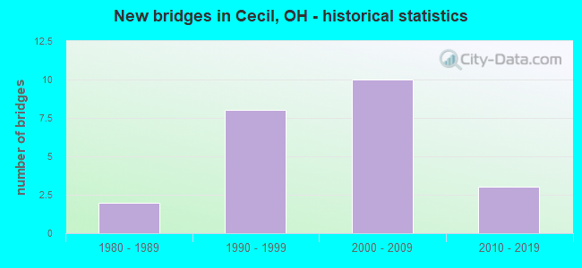
- New bridges - historical statistics
- 21980-1989
- 81990-1999
- 102000-2009
- 32010-2019


- Bridge Condition - Deck
- 44.4%Excellent
- 33.3%Very good
- 16.7%Good
- 5.6%Satisfactory

- Bridge Condition - Superstructure
- 50.0%Excellent
- 27.8%Very good
- 16.7%Good
- 5.6%Satisfactory

- Bridge Condition - Substructure
- 38.9%Excellent
- 38.9%Very good
- 11.1%Good
- 11.1%Satisfactory

- Bridge Condition - Channel
- 13.3%Excellent
- 53.3%Very good
- 13.3%Good
- 20.0%Fair
Find on map >> Show street view
Structure Number: 2043033, Location: 0.55 E OF OPENLANDER RD (Lat: 41.252789, Lng: -84.581411), Route carried "on" structure: County highway T0008, Year Built: 1996, Status: Open, Structure Length: 2.29m (7.51ft), Average Daily Traffic: 46 (year 1995), Average Future Daily Traffic: 64 (year 2015), Design Load: HS 20+Mod, Features Intersected: SOUTH FORK GORDON CREEK, Facility Carried by Structure: DEF/PAU COUNTY LN
Minimum Vertical Clearance: 30+ m (98+ ft), Kilometerpoint: 18.668, Lanes on structure: 2, Owner: County Highway Agency, Approaching Roadway Width: 5.8m (19.0ft), Skew: 1 degrees, Material/Design: Prestressed concrete, Design/Construction: Box Beam or Girders - Multiple, Number Of Spans In Main Unit: 1, Length of Maximum Span: 21.9m (71.9ft), Curb-To-Curb Width: 8.5m (27.9ft), Out-to-Out Width: 8.5m (27.9ft)
Condition: Deck: Very good, Superstructure: Very good, Substructure: Very good, Channel: Very good, Operating Rating: 58.3 metric tons, Method Used To Determine Operating Rating: Load Factor (LF) rating reported by rating factor (RF) method using MS18 loading, Inventory Rating: 35.6 metric tons, Method Used To Determine Inventory Rating: Load Factor (LF) rating reported by rating factor (RF) method using MS18 loading, Structural Evaluation: Equal to present desirable criteria, Deck Geometry: Better than present minimum criteria, Waterway Adequacy: Equal to present desirable criteria, Approach Roadway Alignment: Equal to present desirable criteria, Designated Inspection Frequency: Every 24 months, Inspection Date: November 2021, Deck Structure Type: Concrete Cast-file-Place, Wearing Surface/Protective System: Wearing Surface: Bituminous, Membrane: Preformed Fabric, Deck Protection: Other
Find on map >> Show street view
Structure Number: 2043335, Location: 0.3 MI S OF JERICHO RD (Lat: 41.262089, Lng: -84.649811), Route carried "on" structure: County highway T0121, Year Built: 1991, Status: Open, Structure Length: 1.74m (5.71ft), Average Daily Traffic: 80 (year 2015), Truck Traffic: 8%, Average Future Daily Traffic: 111 (year 2035), Design Load: HS 20+Mod, Features Intersected: GORDON CREEK, Facility Carried by Structure: WONDERLY RD
Minimum Vertical Clearance: 30+ m (98+ ft), Kilometerpoint: 1.127, Lanes on structure: 2, Owner: County Highway Agency, Approaching Roadway Width: 5.8m (19.0ft), Material/Design: Prestressed concrete, Design/Construction: Box Beam or Girders - Multiple, Number Of Spans In Main Unit: 1, Length of Maximum Span: 17.1m (56.1ft), Curb-To-Curb Width: 7.3m (24.0ft), Out-to-Out Width: 7.3m (24.0ft)
Condition: Deck: Very good, Superstructure: Good, Substructure: Very good, Channel: Very good, Operating Rating: 68.0 metric tons, Method Used To Determine Operating Rating: Load Factor (LF) rating reported by rating factor (RF) method using MS18 loading, Inventory Rating: 38.9 metric tons, Method Used To Determine Inventory Rating: Load Factor (LF) rating reported by rating factor (RF) method using MS18 loading, Structural Evaluation: Better than present minimum criteria, Deck Geometry: Equal to present minimum criteria, Waterway Adequacy: Superior to present desirable criteria, Approach Roadway Alignment: Superior to present desirable criteria, Designated Inspection Frequency: Every 24 months, Inspection Date: November 2021, Deck Structure Type: Concrete Cast-file-Place, Wearing Surface/Protective System: Wearing Surface: Bituminous, Membrane: Built-up
Find on map >> Show street view
Structure Number: 2043378, Location: 0.35 MI. E OF FARMER-MARK (Lat: 41.281689, Lng: -84.623889), Route carried "on" structure: County highway C0039, Year Built: 1994, Status: Open, Structure Length: 1.46m (4.79ft), Average Daily Traffic: 145 (year 2015), Truck Traffic: 7%, Average Future Daily Traffic: 201 (year 2035), Design Load: HS 20, Features Intersected: PLATTER CREEK, Facility Carried by Structure: FOUNTAIN STREET
Minimum Vertical Clearance: 30+ m (98+ ft), Kilometerpoint: 9.978, Lanes on structure: 2, Owner: County Highway Agency, Approaching Roadway Width: 5.8m (19.0ft), Skew: 2 degrees, Material/Design: Prestressed concrete, Design/Construction: Box Beam or Girders - Multiple, Number Of Spans In Main Unit: 1, Length of Maximum Span: 13.4m (44.0ft), Curb-To-Curb Width: 7.3m (24.0ft), Out-to-Out Width: 7.3m (24.0ft)
Condition: Deck: Very good, Superstructure: Very good, Substructure: Very good, Channel: Very good, Operating Rating: 61.6 metric tons, Method Used To Determine Operating Rating: Load Factor (LF) rating reported by rating factor (RF) method using MS18 loading, Inventory Rating: 38.9 metric tons, Method Used To Determine Inventory Rating: Load Factor (LF) rating reported by rating factor (RF) method using MS18 loading, Structural Evaluation: Equal to present desirable criteria, Deck Geometry: Somewhat better than minimum adequacy, Waterway Adequacy: Superior to present desirable criteria, Approach Roadway Alignment: Equal to present minimum criteria, Designated Inspection Frequency: Every 24 months, Inspection Date: November 2021, Deck Structure Type: Concrete Cast-file-Place, Wearing Surface/Protective System: Wearing Surface: Bituminous, Membrane: Preformed Fabric, Deck Protection: Other
Find on map >> Show street view
Structure Number: 2043491, Location: 0.4 MI S. OF FOUNTAIN ST. (Lat: 41.276161, Lng: -84.611031), Route carried "on" structure: County highway T0123, Year Built: 1995, Status: Open, Structure Length: 1.46m (4.79ft), Average Daily Traffic: 56 (year 2015), Truck Traffic: 7%, Average Future Daily Traffic: 78 (year 2035), Design Load: HS 20, Features Intersected: PLATTER CREEK, Facility Carried by Structure: WMS. CNT. CECIL RD
Minimum Vertical Clearance: 30+ m (98+ ft), Kilometerpoint: 2.575, Lanes on structure: 2, Owner: County Highway Agency, Approaching Roadway Width: 6.7m (22.0ft), Skew: 2 degrees, Material/Design: Prestressed concrete, Design/Construction: Box Beam or Girders - Multiple, Number Of Spans In Main Unit: 1, Length of Maximum Span: 13.1m (43.0ft), Curb-To-Curb Width: 7.3m (24.0ft), Out-to-Out Width: 7.3m (24.0ft)
Condition: Deck: Good, Superstructure: Good, Substructure: Very good, Channel: Very good, Operating Rating: 55.1 metric tons, Method Used To Determine Operating Rating: Load Factor (LF) rating reported by rating factor (RF) method using MS18 loading, Inventory Rating: 32.4 metric tons, Method Used To Determine Inventory Rating: Load Factor (LF) rating reported by rating factor (RF) method using MS18 loading, Structural Evaluation: Better than present minimum criteria, Deck Geometry: Equal to present minimum criteria, Waterway Adequacy: Equal to present desirable criteria, Approach Roadway Alignment: Superior to present desirable criteria, Designated Inspection Frequency: Every 24 months, Inspection Date: November 2021, Deck Structure Type: Concrete Cast-file-Place, Wearing Surface/Protective System: Wearing Surface: Bituminous, Membrane: Preformed Fabric, Deck Protection: Other
Find on map >> Show street view
Structure Number: 341, Location: 3.90 MI E OF S.R. 800 (Lat: 40.246211, Lng: -81.202200), Route carried "on" structure: State highway 799, Year Built: 2018, Status: Open, Structure Length: 1.71m (5.61ft), Average Daily Traffic: 540 (year 2016), Truck Traffic: 7%, Average Future Daily Traffic: 551 (year 2036), Design Load: HL 93, Features Intersected: CLENDENNING LAKE
Minimum Vertical Clearance: 30+ m (98+ ft), Kilometerpoint: 6.293, Lanes on structure: 2, Base Highway Network: Yes, Owner: State Highway Agency, Approaching Roadway Width: 8.7m (28.5ft), Material/Design: Prestressed concrete, Design/Construction: Box Beam or Girders - Multiple, Number Of Spans In Main Unit: 1, Number Of Approach Spans: 2, Length of Maximum Span: 16.8m (55.1ft), Curb-To-Curb Width: 8.7m (28.5ft), Out-to-Out Width: 8.7m (28.5ft)
Condition: Deck: Excellent, Superstructure: Excellent, Substructure: Excellent, Channel: Excellent, Operating Rating: 58.3 metric tons, Method Used To Determine Operating Rating: Load and Resistance Factor Rating (LRFR) rating reported by rating factor(RF) method using HL-93 loadings, Inventory Rating: 45.4 metric tons, Method Used To Determine Inventory Rating: Load and Resistance Factor Rating (LRFR) rating reported by rating factor(RF) method using HL-93 loadings, Structural Evaluation: Superior to present desirable criteria, Deck Geometry: Somewhat better than minimum adequacy, Waterway Adequacy: Equal to present desirable criteria, Approach Roadway Alignment: Superior to present desirable criteria, Length Of Structure Improvement: 1.68m (5.51ft), Designated Inspection Frequency: Every 24 months, Inspection Date: January 2021, Deck Structure Type: Concrete Cast-file-Place, Wearing Surface/Protective System: Wearing Surface: Monolithic Concrete, Membrane: Epoxy, Deck Protection: Epoxy Coated Reinforcing
Find on map >> Show street view
Structure Number: 6300286, Location: US-24OVER SIX MI CUTOFF (Lat: 41.211239, Lng: -84.612189), Route carried "on" structure: US 24, Year Built: 2009, Status: Open, Structure Length: 0.79m (2.59ft), Average Daily Traffic: 9,708 (year 2015), Truck Traffic: 42%, Average Future Daily Traffic: 13,475 (year 2035), Design Load: HS 25 or greater, Features Intersected: SIX MI CUTOFF
Minimum Vertical Clearance: 30+ m (98+ ft), Kilometerpoint: 17.719, Lanes on structure: 4, Base Highway Network: Yes, Owner: State Highway Agency, Approaching Roadway Width: 11.6m (38.1ft), Material/Design: Concrete, Design/Construction: Culvert, Number Of Spans In Main Unit: 1, Length of Maximum Span: 7.3m (24.0ft)
Condition: Channel: Good, Culverts: Excellent, Operating Rating: 42.1 metric tons, Method Used To Determine Operating Rating: Load Factor (LF) rating reported by rating factor (RF) method using MS18 loading, Inventory Rating: 32.4 metric tons, Method Used To Determine Inventory Rating: Load Factor (LF) rating reported by rating factor (RF) method using MS18 loading, Structural Evaluation: Equal to present desirable criteria, Waterway Adequacy: Superior to present desirable criteria, Approach Roadway Alignment: Equal to present desirable criteria, Designated Inspection Frequency: Every 24 months, Inspection Date: May 2020
Find on map >> Show street view
Structure Number: 6300294, Location: .25 MILES EAST OF US 27 (Lat: 41.225839, Lng: -84.570569), Route carried "on" structure: US 24, Year Built: 2009, Status: Open, Structure Length: 2.71m (8.89ft), Average Daily Traffic: 3,434 (year 2015), Truck Traffic: 42%, Average Future Daily Traffic: 4,766 (year 2035), Design Load: HS 25 or greater, Features Intersected: MAUMEE & WESTERN (RMW) R
Minimum Vertical Clearance: 30+ m (98+ ft), Kilometerpoint: 21.742, Lanes on structure: 2, Base Highway Network: Yes, Owner: State Highway Agency, Approaching Roadway Width: 11.6m (38.1ft), Skew: 4 degrees, Material/Design: Prestressed concrete, Design/Construction: Stringer/Multi-beam, Number Of Spans In Main Unit: 1, Length of Maximum Span: 25.6m (84.0ft), Curb-To-Curb Width: 12.8m (42.0ft), Out-to-Out Width: 13.7m (44.9ft)
Condition: Deck: Excellent, Superstructure: Excellent, Substructure: Excellent, Operating Rating: 42.1 metric tons, Method Used To Determine Operating Rating: Load Factor (LF) rating reported by rating factor (RF) method using MS18 loading, Inventory Rating: 32.4 metric tons, Method Used To Determine Inventory Rating: Load Factor (LF) rating reported by rating factor (RF) method using MS18 loading, Structural Evaluation: Equal to present desirable criteria, Deck Geometry: Equal to present minimum criteria, Underclear: Superior to present desirable criteria, Approach Roadway Alignment: Equal to present desirable criteria, Designated Inspection Frequency: Every 24 months, Inspection Date: May 2020, Deck Structure Type: Concrete Cast-file-Place, Wearing Surface/Protective System: Wearing Surface: Monolithic Concrete, Deck Protection: Epoxy Coated Reinforcing
Find on map >> Show street view
Structure Number: 6300308, Location: .25 MILES EAST OF US 127 (Lat: 41.225939, Lng: -84.570169), Route carried "on" structure: Spur US 24, Year Built: 2009, Status: Open, Structure Length: 2.71m (8.89ft), Average Daily Traffic: 3,434 (year 2015), Truck Traffic: 42%, Average Future Daily Traffic: 4,766 (year 2035), Design Load: HS 25 or greater, Features Intersected: MAUMEE & WESTERN (RMW) R
Minimum Vertical Clearance: 30+ m (98+ ft), Kilometerpoint: 21.742, Lanes on structure: 2, Base Highway Network: Yes, Owner: State Highway Agency, Approaching Roadway Width: 11.6m (38.1ft), Skew: 4 degrees, Material/Design: Prestressed concrete, Design/Construction: Stringer/Multi-beam, Number Of Spans In Main Unit: 1, Length of Maximum Span: 25.6m (84.0ft), Curb-To-Curb Width: 12.8m (42.0ft), Out-to-Out Width: 13.7m (44.9ft)
Condition: Deck: Excellent, Superstructure: Excellent, Substructure: Excellent, Operating Rating: 42.1 metric tons, Method Used To Determine Operating Rating: Load Factor (LF) rating reported by rating factor (RF) method using MS18 loading, Inventory Rating: 32.4 metric tons, Method Used To Determine Inventory Rating: Load Factor (LF) rating reported by rating factor (RF) method using MS18 loading, Structural Evaluation: Equal to present desirable criteria, Deck Geometry: Equal to present minimum criteria, Underclear: Somewhat better than minimum adequacy, Approach Roadway Alignment: Equal to present desirable criteria, Designated Inspection Frequency: Every 24 months, Inspection Date: May 2020, Deck Structure Type: Concrete Cast-file-Place, Wearing Surface/Protective System: Wearing Surface: Monolithic Concrete, Deck Protection: Epoxy Coated Reinforcing
Find on map >> Show street view
Structure Number: 6300316, Location: US-24 OVER CR-105 (Lat: 41.211989, Lng: -84.602481), Route carried "on" structure: US 24, Year Built: 2009, Status: Open, Structure Length: 7.68m (25.20ft), Average Daily Traffic: 4,854 (year 2015), Truck Traffic: 42%, Average Future Daily Traffic: 6,737 (year 2035), Design Load: HS 25 or greater, Features Intersected: CR 105 & PORTLAND RR
Minimum Vertical Clearance: 30+ m (98+ ft), Kilometerpoint: 18.540, Lanes on structure: 2, Lanes under structure: 3, Base Highway Network: Yes, Owner: State Highway Agency, Approaching Roadway Width: 11.6m (38.1ft), Skew: 2 degrees, Material/Design: Prestressed concrete continuous, Design/Construction: Stringer/Multi-beam, Number Of Spans In Main Unit: 3, Length of Maximum Span: 24.4m (80.1ft), Curb-To-Curb Width: 12.8m (42.0ft), Out-to-Out Width: 13.7m (44.9ft)
Condition: Deck: Excellent, Superstructure: Excellent, Substructure: Excellent, Operating Rating: 42.1 metric tons, Method Used To Determine Operating Rating: Load Factor (LF) rating reported by rating factor (RF) method using MS18 loading, Inventory Rating: 32.4 metric tons, Method Used To Determine Inventory Rating: Load Factor (LF) rating reported by rating factor (RF) method using MS18 loading, Structural Evaluation: Equal to present desirable criteria, Deck Geometry: Equal to present minimum criteria, Underclear: Superior to present desirable criteria, Approach Roadway Alignment: Equal to present desirable criteria, Designated Inspection Frequency: Every 24 months, Inspection Date: May 2020, Deck Structure Type: Concrete Cast-file-Place, Wearing Surface/Protective System: Wearing Surface: Monolithic Concrete, Deck Protection: Epoxy Coated Reinforcing
Find on map >> Show street view
Structure Number: 6300332, Location: US-24 OVER CR-105 (Lat: 41.211731, Lng: -84.602450), Route carried "on" structure: US 24, Year Built: 2009, Status: Open, Structure Length: 7.68m (25.20ft), Average Daily Traffic: 4,854 (year 2015), Truck Traffic: 42%, Average Future Daily Traffic: 6,737 (year 2035), Design Load: HS 25 or greater, Features Intersected: CR 105 & PORTLAND RR
Minimum Vertical Clearance: 30+ m (98+ ft), Kilometerpoint: 18.540, Lanes on structure: 2, Lanes under structure: 3, Base Highway Network: Yes, Owner: State Highway Agency, Approaching Roadway Width: 11.6m (38.1ft), Skew: 2 degrees, Material/Design: Prestressed concrete continuous, Design/Construction: Stringer/Multi-beam, Number Of Spans In Main Unit: 2, Length of Maximum Span: 24.4m (80.1ft), Curb-To-Curb Width: 12.8m (42.0ft), Out-to-Out Width: 13.7m (44.9ft)
Condition: Deck: Excellent, Superstructure: Excellent, Substructure: Excellent, Operating Rating: 42.1 metric tons, Method Used To Determine Operating Rating: Load Factor (LF) rating reported by rating factor (RF) method using MS18 loading, Inventory Rating: 32.4 metric tons, Method Used To Determine Inventory Rating: Load Factor (LF) rating reported by rating factor (RF) method using MS18 loading, Structural Evaluation: Equal to present desirable criteria, Deck Geometry: Equal to present minimum criteria, Underclear: Superior to present desirable criteria, Approach Roadway Alignment: Equal to present desirable criteria, Designated Inspection Frequency: Every 24 months, Inspection Date: May 2020, Deck Structure Type: Concrete Cast-file-Place, Wearing Surface/Protective System: Wearing Surface: Monolithic Concrete, Deck Protection: Epoxy Coated Reinforcing
Find on map >> Show street view
Structure Number: 6301495, Location: SR-127 OVER US-24 (Lat: 41.219350, Lng: -84.582781), Route carried "on" structure: US 127, Year Built: 2008, Status: Open, Structure Length: 5.97m (19.59ft), Average Daily Traffic: 3,359 (year 2015), Truck Traffic: 21%, Average Future Daily Traffic: 4,662 (year 2035), Design Load: HS 25 or greater, Features Intersected: USR 24
Minimum Vertical Clearance: 30+ m (98+ ft), Kilometerpoint: 25.927, Lanes on structure: 3, Lanes under structure: 4, Base Highway Network: Yes, Owner: State Highway Agency, Approaching Roadway Width: 17.1m (56.1ft), Skew: 2 degrees, Material/Design: Prestressed concrete continuous, Design/Construction: Stringer/Multi-beam, Number Of Spans In Main Unit: 2, Length of Maximum Span: 29.3m (96.1ft), Curb-To-Curb Width: 18.3m (60.0ft), Out-to-Out Width: 19.2m (63.0ft)
Condition: Deck: Very good, Superstructure: Excellent, Substructure: Excellent, Operating Rating: 42.1 metric tons, Method Used To Determine Operating Rating: Load Factor (LF) rating reported by rating factor (RF) method using MS18 loading, Inventory Rating: 32.4 metric tons, Method Used To Determine Inventory Rating: Load Factor (LF) rating reported by rating factor (RF) method using MS18 loading, Structural Evaluation: Equal to present desirable criteria, Deck Geometry: Superior to present desirable criteria, Underclear: Better than present minimum criteria, Approach Roadway Alignment: Equal to present desirable criteria, Designated Inspection Frequency: Every 24 months, Inspection Date: May 2020, Deck Structure Type: Concrete Cast-file-Place, Wearing Surface/Protective System: Wearing Surface: Monolithic Concrete, Deck Protection: Epoxy Coated Reinforcing
Find on map >> Show street view
Structure Number: 63308, Location: 1/2 MILE NORTH OF US 24 (Lat: 41.238331, Lng: -84.601669), Route carried "on" structure: County highway C0105, Year Built: 1999, Status: Open, Structure Length: 12.44m (40.81ft), Average Daily Traffic: 477 (year 2015), Truck Traffic: 8%, Average Future Daily Traffic: 662 (year 2035), Design Load: HS 20+Mod, Features Intersected: MAUMEE RIVER, Facility Carried by Structure: COUNTY ROAD 105
Minimum Vertical Clearance: 30+ m (98+ ft), Kilometerpoint: 4.812, Lanes on structure: 2, Owner: County Highway Agency, Approaching Roadway Width: 11.0m (36.1ft), Skew: 3 degrees, Material/Design: Prestressed concrete, Design/Construction: Box Beam or Girders - Multiple, Number Of Spans In Main Unit: 4, Length of Maximum Span: 30.5m (100.1ft), Curb-To-Curb Width: 9.8m (32.2ft), Out-to-Out Width: 9.8m (32.2ft)
Condition: Deck: Very good, Superstructure: Very good, Substructure: Good, Channel: Very good, Operating Rating: 64.8 metric tons, Method Used To Determine Operating Rating: Load Factor (LF) rating reported by rating factor (RF) method using MS18 loading, Inventory Rating: 38.9 metric tons, Method Used To Determine Inventory Rating: Load Factor (LF) rating reported by rating factor (RF) method using MS18 loading, Structural Evaluation: Better than present minimum criteria, Deck Geometry: Equal to present minimum criteria, Waterway Adequacy: Equal to present minimum criteria, Approach Roadway Alignment: Better than present minimum criteria, Designated Inspection Frequency: Every 24 months, Inspection Date: September 2021, Deck Structure Type: Concrete Cast-file-Place, Wearing Surface/Protective System: Wearing Surface: Bituminous
Find on map >> Show street view
Structure Number: 633094, Location: DEF. CO. LINE AT C89 (Lat: 41.252719, Lng: -84.630881), Route carried "on" structure: County highway T0008, Year Built: 2010, Status: Open, Structure Length: 1.77m (5.81ft), Average Daily Traffic: 179 (year 2015), Truck Traffic: 8%, Average Future Daily Traffic: 248 (year 2035), Design Load: HL 93, Features Intersected: GORDON CREEK, Facility Carried by Structure: TOWNSHIP ROAD 8
Minimum Vertical Clearance: 30+ m (98+ ft), Kilometerpoint: 14.484, Lanes on structure: 2, Owner: County Highway Agency, Approaching Roadway Width: 8.5m (27.9ft), Material/Design: Prestressed concrete, Design/Construction: Box Beam or Girders - Multiple, Number Of Spans In Main Unit: 1, Length of Maximum Span: 17.7m (58.1ft), Curb-To-Curb Width: 8.5m (27.9ft), Out-to-Out Width: 8.5m (27.9ft)
Condition: Deck: Excellent, Superstructure: Excellent, Substructure: Satisfactory, Channel: Fair, Operating Rating: 68.0 metric tons, Method Used To Determine Operating Rating: Load Factor (LF) rating reported by rating factor (RF) method using MS18 loading, Inventory Rating: 42.1 metric tons, Method Used To Determine Inventory Rating: Load Factor (LF) rating reported by rating factor (RF) method using MS18 loading, Structural Evaluation: Equal to present minimum criteria, Deck Geometry: Equal to present minimum criteria, Waterway Adequacy: Equal to present desirable criteria, Approach Roadway Alignment: Equal to present minimum criteria, Designated Inspection Frequency: Every 12 months, Inspection Date: July 2021, Deck Structure Type: Concrete Cast-file-Place, Wearing Surface/Protective System: Wearing Surface: Bituminous, Membrane: Preformed Fabric, Deck Protection: Internally Sealed
Find on map >> Show street view
Structure Number: 6331068, Location: 1.9 MI N OF JCT US24 (Lat: 41.236669, Lng: -84.670000), Route carried "on" structure: County highway C0073, Year Built: 1987, Status: Open, Structure Length: 2.71m (8.89ft), Average Daily Traffic: 224 (year 2015), Truck Traffic: 8%, Average Future Daily Traffic: 311 (year 2035), Design Load: HS 20, Features Intersected: MARIE DELARME CREEK, Facility Carried by Structure: COUNTY ROAD 73
Minimum Vertical Clearance: 30+ m (98+ ft), Kilometerpoint: 3.058, Lanes on structure: 2, Owner: County Highway Agency, Approaching Roadway Width: 8.5m (27.9ft), Skew: 1 degrees, Material/Design: Prestressed concrete, Design/Construction: Box Beam or Girders - Multiple, Number Of Spans In Main Unit: 2, Length of Maximum Span: 13.1m (43.0ft), Curb-To-Curb Width: 8.5m (27.9ft), Out-to-Out Width: 8.5m (27.9ft)
Condition: Deck: Good, Superstructure: Very good, Substructure: Good, Channel: Very good, Operating Rating: 51.8 metric tons, Method Used To Determine Operating Rating: Load Factor (LF) rating reported by rating factor (RF) method using MS18 loading, Inventory Rating: 32.4 metric tons, Method Used To Determine Inventory Rating: Load Factor (LF) rating reported by rating factor (RF) method using MS18 loading, Structural Evaluation: Better than present minimum criteria, Deck Geometry: Equal to present minimum criteria, Waterway Adequacy: Somewhat better than minimum adequacy, Approach Roadway Alignment: Better than present minimum criteria, Length Of Structure Improvement: 8.99m (29.49ft), Designated Inspection Frequency: Every 24 months, Inspection Date: August 2021, Bridge Improvement Cost: $156,000, Roadway Improvement Cost: $56,000, Total Project Cost: $235,000, Deck Structure Type: Concrete Cast-file-Place, Wearing Surface/Protective System: Wearing Surface: Monolithic Concrete
Find on map >> Show street view
Structure Number: 6331254, Location: 1.2 MI N. OF SR 111 (Lat: 41.210700, Lng: -84.553439), Route carried "on" structure: County highway C0115, Year Built: 2009, Status: Open, Structure Length: 2.04m (6.69ft), Average Daily Traffic: 597 (year 2015), Truck Traffic: 8%, Average Future Daily Traffic: 829 (year 2035), Design Load: HL 93, Features Intersected: SIX MILE CREEK, Facility Carried by Structure: COUNTY ROAD 115
Minimum Vertical Clearance: 30+ m (98+ ft), Kilometerpoint: 8.304, Lanes on structure: 2, Owner: County Highway Agency, Approaching Roadway Width: 11.0m (36.1ft), Skew: 3 degrees, Material/Design: Prestressed concrete, Design/Construction: Box Beam or Girders - Multiple, Number Of Spans In Main Unit: 1, Length of Maximum Span: 19.8m (65.0ft), Curb-To-Curb Width: 11.0m (36.1ft), Out-to-Out Width: 11.0m (36.1ft)
Condition: Deck: Very good, Superstructure: Very good, Substructure: Very good, Channel: Excellent, Operating Rating: 42.1 metric tons, Method Used To Determine Operating Rating: Load Factor (LF) rating reported by rating factor (RF) method using MS18 loading, Inventory Rating: 32.4 metric tons, Method Used To Determine Inventory Rating: Load Factor (LF) rating reported by rating factor (RF) method using MS18 loading, Structural Evaluation: Equal to present desirable criteria, Deck Geometry: Better than present minimum criteria, Waterway Adequacy: Superior to present desirable criteria, Approach Roadway Alignment: Better than present minimum criteria, Designated Inspection Frequency: Every 24 months, Inspection Date: September 2020, Deck Structure Type: Concrete Cast-file-Place, Wearing Surface/Protective System: Wearing Surface: Bituminous, Membrane: Epoxy, Deck Protection: Epoxy Coated Reinforcing
Find on map >> Show street view
Structure Number: 6332633, Location: AT INTERSECTION OF T97 (Lat: 41.208539, Lng: -84.612150), Route carried "on" structure: County highway C0206, Year Built: 2011, Status: Open, Structure Length: 0.73m (2.40ft), Average Daily Traffic: 477 (year 2015), Truck Traffic: 8%, Average Future Daily Traffic: 662 (year 2035), Design Load: HL 93, Features Intersected: SIX MILE CUTOFF, Facility Carried by Structure: COUNTY ROAD 206
Minimum Vertical Clearance: 30+ m (98+ ft), Kilometerpoint: 6.421, Lanes on structure: 2, Owner: County Highway Agency, Approaching Roadway Width: 7.3m (24.0ft), Material/Design: Concrete, Design/Construction: Culvert, Number Of Spans In Main Unit: 1, Length of Maximum Span: 7.3m (24.0ft)
Condition: Channel: Very good, Culverts: Excellent, Operating Rating: 40.8 metric tons, Method Used To Determine Operating Rating: Field evaluation and documented engineering judgment, Inventory Rating: 32.7 metric tons, Method Used To Determine Inventory Rating: Field evaluation and documented engineering judgment, Structural Evaluation: Superior to present desirable criteria, Waterway Adequacy: Equal to present desirable criteria, Approach Roadway Alignment: Superior to present desirable criteria, Designated Inspection Frequency: Every 24 months, Inspection Date: September 2020
Find on map >> Show street view
Structure Number: 633418, Location: 0.22 MI NORTH OF US 24 (Lat: 41.221939, Lng: -84.670000), Route carried "on" structure: County highway C0073, Year Built: 1996, Status: Open, Structure Length: 11.73m (38.48ft), Average Daily Traffic: 224 (year 2015), Truck Traffic: 8%, Average Future Daily Traffic: 311 (year 2035), Design Load: HS 20+Mod, Features Intersected: MAUMEE RIVER, Facility Carried by Structure: COUNTY ROAD 73
Minimum Vertical Clearance: 30+ m (98+ ft), Kilometerpoint: 0.354, Lanes on structure: 2, Owner: County Highway Agency, Approaching Roadway Width: 8.5m (27.9ft), Material/Design: Prestressed concrete continuous, Design/Construction: Box Beam or Girders - Multiple, Number Of Spans In Main Unit: 4, Length of Maximum Span: 28.7m (94.2ft), Curb-To-Curb Width: 8.5m (27.9ft), Out-to-Out Width: 8.5m (27.9ft)
Condition: Deck: Good, Superstructure: Good, Substructure: Satisfactory, Channel: Very good, Operating Rating: 55.1 metric tons, Method Used To Determine Operating Rating: Load Factor (LF) rating reported by rating factor (RF) method using MS18 loading, Inventory Rating: 32.4 metric tons, Method Used To Determine Inventory Rating: Load Factor (LF) rating reported by rating factor (RF) method using MS18 loading, Structural Evaluation: Equal to present minimum criteria, Deck Geometry: Equal to present minimum criteria, Waterway Adequacy: Superior to present desirable criteria, Approach Roadway Alignment: Better than present minimum criteria, Designated Inspection Frequency: Every 12 months, Inspection Date: August 2021, Deck Structure Type: Concrete Cast-file-Place, Wearing Surface/Protective System: Wearing Surface: Bituminous, Membrane: Built-up, Deck Protection: Epoxy Coated Reinforcing
Find on map >> Show street view
Structure Number: 6334253, Location: 0.4 MI W OF JCT C105 (Lat: 41.223331, Lng: -84.610000), Route carried "on" structure: County highway T0224, Year Built: 1990, Status: Open, Structure Length: 2.80m (9.19ft), Average Daily Traffic: 351 (year 2015), Truck Traffic: 7%, Average Future Daily Traffic: 487 (year 2035), Design Load: HS 20, Features Intersected: SIXMILE CUTOFF, Facility Carried by Structure: TOWNSHIP ROA 224
Minimum Vertical Clearance: 30+ m (98+ ft), Kilometerpoint: 1.996, Lanes on structure: 2, Owner: County Highway Agency, Approaching Roadway Width: 4.9m (16.1ft), Material/Design: Prestressed concrete, Design/Construction: Stringer/Multi-beam, Number Of Spans In Main Unit: 1, Length of Maximum Span: 27.4m (89.9ft), Curb-To-Curb Width: 8.5m (27.9ft), Out-to-Out Width: 8.5m (27.9ft)
Condition: Deck: Excellent, Superstructure: Excellent, Substructure: Excellent, Channel: Good, Operating Rating: 48.6 metric tons, Method Used To Determine Operating Rating: Load Factor (LF) rating reported by rating factor (RF) method using MS18 loading, Inventory Rating: 29.2 metric tons, Method Used To Determine Inventory Rating: Load Factor (LF) rating reported by rating factor (RF) method using MS18 loading, Structural Evaluation: Better than present minimum criteria, Deck Geometry: Equal to present minimum criteria, Waterway Adequacy: Better than present minimum criteria, Approach Roadway Alignment: Somewhat better than minimum adequacy, Length Of Structure Improvement: 5.03m (16.50ft), Designated Inspection Frequency: Every 24 months, Inspection Date: December 2021, Bridge Improvement Cost: $148,000, Roadway Improvement Cost: $54,000, Total Project Cost: $245,000, Deck Structure Type: Concrete Cast-file-Place, Wearing Surface/Protective System: Wearing Surface: Monolithic Concrete, Membrane: Built-up, Deck Protection: Epoxy Coated Reinforcing
Find on map >> Show street view
Structure Number: 6334296, Location: 0.1 MI N OF JCT C230 (Lat: 41.247000, Lng: -84.601739), Route carried "on" structure: County highway T0105, Year Built: 1984, Status: Open, Structure Length: 2.62m (8.60ft), Average Daily Traffic: 477 (year 2015), Truck Traffic: 8%, Average Future Daily Traffic: 662 (year 2035), Features Intersected: GORDON CREEK, Facility Carried by Structure: TOWNSHIP ROAD 105
Minimum Vertical Clearance: 30+ m (98+ ft), Kilometerpoint: 5.842, Lanes on structure: 2, Owner: County Highway Agency, Approaching Roadway Width: 7.3m (24.0ft), Material/Design: Prestressed concrete, Design/Construction: Box Beam or Girders - Multiple, Number Of Spans In Main Unit: 1, Length of Maximum Span: 24.4m (80.1ft), Curb-To-Curb Width: 7.3m (24.0ft), Out-to-Out Width: 7.4m (24.3ft)
Condition: Deck: Satisfactory, Superstructure: Satisfactory, Substructure: Very good, Channel: Fair, Operating Rating: 42.1 metric tons, Method Used To Determine Operating Rating: Load Factor (LF) rating reported by rating factor (RF) method using MS18 loading, Inventory Rating: 29.2 metric tons, Method Used To Determine Inventory Rating: Load Factor (LF) rating reported by rating factor (RF) method using MS18 loading, Structural Evaluation: Equal to present minimum criteria, Deck Geometry: Meets minimum limits, Waterway Adequacy: Better than present minimum criteria, Approach Roadway Alignment: Better than present minimum criteria, Designated Inspection Frequency: Every 12 months, Inspection Date: July 2021, Deck Structure Type: Other, Wearing Surface/Protective System: Wearing Surface: Bituminous
Find on map >> Show street view
Structure Number: 6334326, Location: 0.7 MI S OF JCT C230 (Lat: 41.228331, Lng: -84.653331), Route carried "on" structure: County highway T0192, Year Built: 1992, Status: Open, Structure Length: 3.20m (10.50ft), Average Daily Traffic: 96 (year 2015), Truck Traffic: 7%, Average Future Daily Traffic: 133 (year 2035), Design Load: HS 20, Features Intersected: MARIE DELARME CREEK, Facility Carried by Structure: TOWNSHIP ROAD 192
Minimum Vertical Clearance: 30+ m (98+ ft), Kilometerpoint: 15.530, Lanes on structure: 2, Owner: County Highway Agency, Approaching Roadway Width: 5.2m (17.1ft), Material/Design: Prestressed concrete, Design/Construction: Box Beam or Girders - Multiple, Number Of Spans In Main Unit: 3, Length of Maximum Span: 12.5m (41.0ft), Curb-To-Curb Width: 8.5m (27.9ft), Out-to-Out Width: 8.5m (27.9ft)
Condition: Deck: Excellent, Superstructure: Excellent, Substructure: Very good, Channel: Fair, Operating Rating: 58.3 metric tons, Method Used To Determine Operating Rating: Load Factor (LF) rating reported by rating factor (RF) method using MS18 loading, Inventory Rating: 35.6 metric tons, Method Used To Determine Inventory Rating: Load Factor (LF) rating reported by rating factor (RF) method using MS18 loading, Structural Evaluation: Equal to present desirable criteria, Deck Geometry: Better than present minimum criteria, Waterway Adequacy: Superior to present desirable criteria, Approach Roadway Alignment: Better than present minimum criteria, Length Of Structure Improvement: 8.84m (29.00ft), Designated Inspection Frequency: Every 24 months, Inspection Date: December 2021, Bridge Improvement Cost: $144,000, Roadway Improvement Cost: $74,000, Total Project Cost: $281,000, Deck Structure Type: Concrete Cast-file-Place, Wearing Surface/Protective System: Wearing Surface: Bituminous, Membrane: Built-up
Find on map >> Show street view
Structure Number: 6300316, Location: US-24 OVER CR-105 (Lat: 41.211989, Lng: -84.602481), Route carried "under" structure: County highway 105, Year Built: 2009, Structure Length: 0. m, Average Daily Traffic: 324 (year 2015), Truck Traffic: 7%, Features Intersected: USR 24, Facility Carried by Structure: USR 24 WB
Minimum Vertical Clearance: 7.26m (23.82ft), Kilometerpoint: 0.000, Lanes on structure: 2, Lanes under structure: 3, Material/Design: Prestressed concrete continuous, Design/Construction: Stringer/Multi-beam, Length of Maximum Span: 24.4m (80.1ft)
Find on map >> Show street view
Structure Number: 6300332, Location: US-24 OVER CR-105 (Lat: 41.211731, Lng: -84.602450), Route carried "under" structure: County highway 105, Year Built: 2009, Structure Length: 0. m, Average Daily Traffic: 324 (year 2015), Truck Traffic: 7%, Features Intersected: USR 24, Facility Carried by Structure: USR 24 EB
Minimum Vertical Clearance: 7.26m (23.82ft), Kilometerpoint: 0.000, Lanes on structure: 2, Lanes under structure: 3, Material/Design: Prestressed concrete continuous, Design/Construction: Stringer/Multi-beam, Length of Maximum Span: 24.4m (80.1ft)
Find on map >> Show street view
Structure Number: 6301495, Location: SR-127 OVER US-24 (Lat: 41.219350, Lng: -84.582781), Route carried "under" structure: US 24, Year Built: 2008, Structure Length: 0. m, Average Daily Traffic: 8,288 (year 2015), Truck Traffic: 42%, Features Intersected: US 127, Facility Carried by Structure: USR 127
Minimum Vertical Clearance: 5.79m (19.00ft), Kilometerpoint: 20.406, Lanes on structure: 3, Lanes under structure: 4, Material/Design: Prestressed concrete continuous, Design/Construction: Stringer/Multi-beam, Length of Maximum Span: 29.3m (96.1ft)